


Vintage 3D Map of the Appalachian Trail: The Unique Maps Co. Relief Map of the Great Smoky Mountains, Shenandoah, White Mountain, Etc.
The Collector’s Offer
Choose two eligible works and receive 20% off both. Choose three and the lowest-priced one is complimentary, a maximum saving of 33%.
Mix and match eligible standard maps and fine-art prints. No code is required; the offer is applied automatically at checkout.
Standard made-to-order configurations are included. Bespoke sizes, personalised designs and commissioned work are excluded.
Need delivery to different addresses? Contact us before ordering.The Collector’s Offer
Choose two eligible works and receive 20% off both. Choose three and the lowest-priced one is complimentary, a maximum saving of 33%.
Mix and match eligible standard maps and fine-art prints. No code is required; the offer is applied automatically at checkout.
Standard made-to-order configurations are included. Bespoke sizes, personalised designs and commissioned work are excluded.
Need delivery to different addresses? Contact us before ordering. Designed in London Made in the USA
Designed in London • Made in the USA
Designed in London Made in the USA
Designed in London • Made in the USA

Restored from the original 2025 map and printed to museum-grade archival standards. Read the story behind this map
Choose your size
Choose your finish


(More info)
Gift message & custom finish

If you want to add a gift message, or a finish (jigsaw, aluminium board, etc.) that is not available here, please request it in the "order note" when you check out.
Every order is custom made, so if you need the size adjusted slightly, or printed on an unusual material, just let us know. We've done thousands of custom orders over the years, so there's (almost) nothing we can't manage.
You can also contact us before you order, if you prefer!

- Made locally for fast, safe delivery
- No import duty or hidden fees
- Need advice? Call us or message on WhatsApp
Own a piece of history
8,000+ five-star reviews


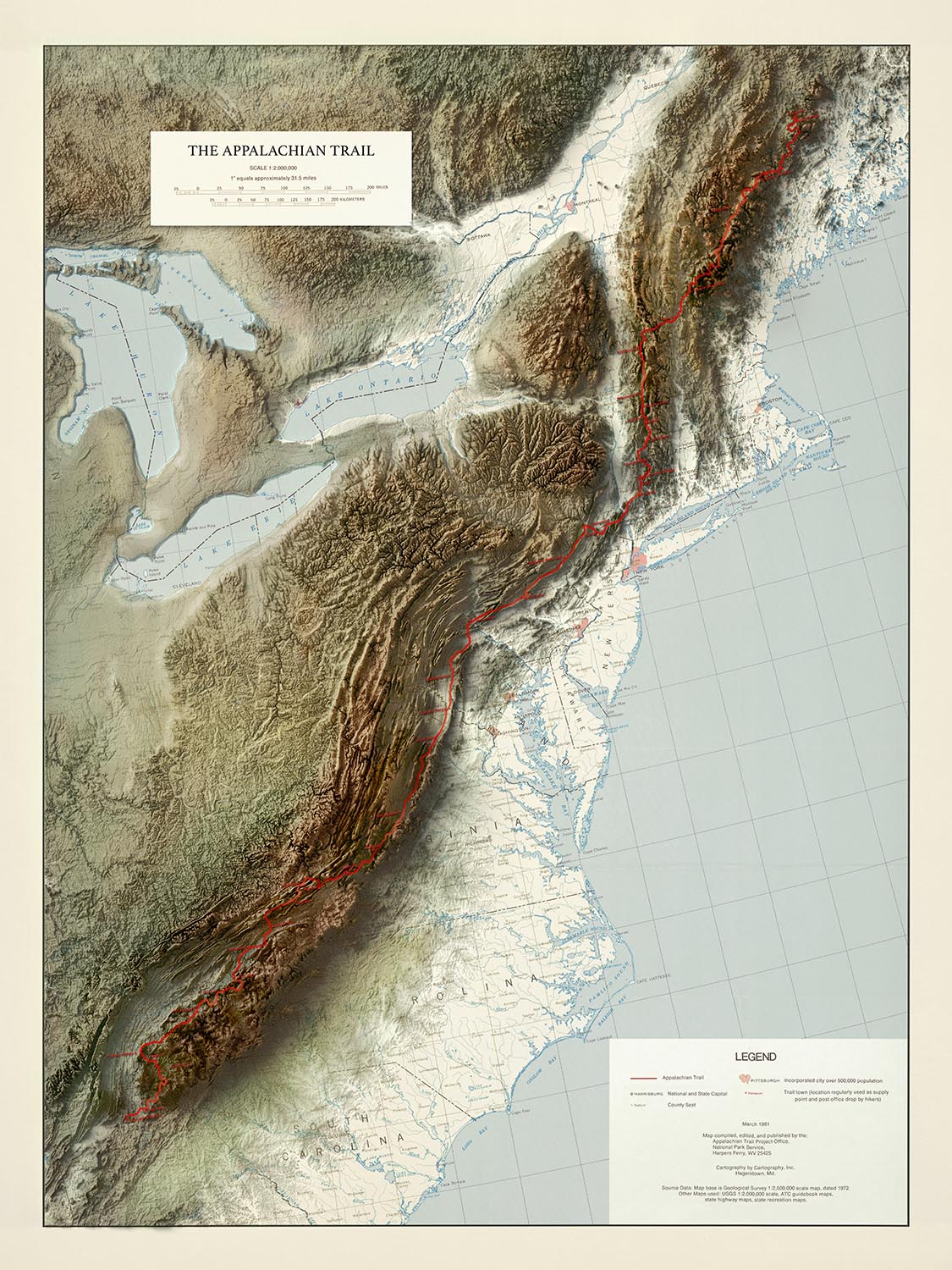
The Appalachian Trail - 3D Relief Map by The Unique Maps Co. is a masterful cartographic achievement, blending the artistry of traditional...
Continue readingThe Appalachian Trail - 3D Relief Map by The Unique Maps Co. is a masterful cartographic achievement, blending the artistry of traditional mapmaking with cutting-edge technology. Drawing inspiration from a vintage original produced by the United States National Park Service, this 2025 edition has been meticulously updated using high-resolution satellite imagery and the latest topographical data. The result is a breathtakingly realistic 3D relief map that captures the rugged beauty and dramatic elevations of the Appalachian Mountains, stretching from the rolling hills of Georgia to the wilds of northern Maine. The map’s original title, a testament to its heritage and authority, signals its roots in the grand tradition of American exploration and conservation.
The Unique Maps Co., renowned for their dedication to both historical authenticity and visual innovation, have created a map that is as much a work of art as it is a navigational tool. Their approach combines painstaking research with advanced digital rendering, producing a piece that highlights not only the physical contours of the land but also the enduring spirit of the Appalachian Trail. Every detail—from the subtle shading of valleys to the bold red line marking the trail’s winding path—reflects a deep reverence for the landscape and its storied past.
This map offers a sweeping view of the eastern United States, encompassing a vast array of natural wonders and historic regions. The trail itself is flanked by iconic national parks such as the Great Smoky Mountains and Shenandoah, as well as legendary forests like the White Mountain and Green Mountain National Forests. Majestic rivers, including the Hudson, Connecticut, and Susquehanna, snake across the terrain, while the shimmering blue of Lakes Erie, Ontario, and Huron anchor the map’s western edge. The relief style brings to life the undulating ridges of the Blue Ridge and Catskill Mountains, inviting the viewer to trace the journey from Springer Mountain to Mount Katahdin.
Beyond its natural grandeur, the map is a window into the cultural and historical fabric of the Appalachian region. The highlighted trail towns—many of which have become legendary among hikers—serve as gateways to the diverse communities, traditions, and histories that have shaped the trail’s legacy. Major cities such as Atlanta, Washington D.C., and Pittsburgh are depicted alongside storied smaller towns like Harpers Ferry and Damascus, illustrating the trail’s unique ability to bridge urban and rural America. Each settlement is carefully placed, reflecting both its modern significance and its historical role in the development of the region.
The Appalachian Trail itself stands as a monument to American perseverance and vision, conceived in the early 20th century as a continuous footpath through the wild heart of the East. This map not only charts its physical course but also evokes the sense of adventure and discovery that has drawn generations of hikers to its path. Whether displayed as a statement piece or studied for its wealth of geographic and historical detail, The Appalachian Trail - 3D Relief Map by The Unique Maps Co. is an invitation to explore, to remember, and to celebrate one of America’s greatest natural treasures.
Cities and towns on this map
- Atlanta, Georgia
- Washington, D.C.
- Pittsburgh, Pennsylvania
- Charlotte, North Carolina
- Knoxville, Tennessee
- Roanoke, Virginia
- Harrisburg, Pennsylvania
- Asheville, North Carolina
- Chattanooga, Tennessee
- Scranton, Pennsylvania
- Frederick, Maryland
- Lynchburg, Virginia
- Johnson City, Tennessee
- Hagerstown, Maryland
- Hanover, New Hampshire
- Rutland, Vermont
- Bennington, Vermont
- Dalton, Massachusetts
- Damascus, Virginia
- Harpers Ferry, West Virginia
Notable Features & Landmarks
- Appalachian Trail (clearly marked in red)
- Great Smoky Mountains National Park
- Shenandoah National Park
- White Mountain National Forest
- Green Mountain National Forest
- Baxter State Park (location of Mount Katahdin)
- Springer Mountain (southern terminus of the trail)
- Mount Katahdin (northern terminus of the trail)
- Blue Ridge Mountains
- Catskill Mountains
- Adirondack Mountains (visible but trail does not pass directly through)
- Major rivers clearly visible, including the Hudson River, Connecticut River, and Susquehanna River
- Lakes Erie, Ontario, and Huron (partially visible on the left edge of the map)
Historical and design context
- Based on a vintage map by the "United States National Park Service, Appalachian Trail Project Office," updated in 2025 with high-resolution satellite imagery and topography data.
- The Unique Maps Co., renowned for their dedication to both historical authenticity and visual innovation, created this map.
- Realistic 3D relief style, visually appealing, emphasizing topographical detail and elevation.
- The Appalachian Trail is a historically significant long-distance hiking trail, established in the early 20th century, stretching approximately 2,190 miles through diverse ecosystems and landscapes.
- The map’s original title is "The Appalachian Trail - 3D Relief Map by The Unique Maps Co."
- The map covers the eastern seaboard of the USA, from Springer Mountain in Georgia to Mount Katahdin in Maine, including parts of the Great Lakes region.
Please double check the images to make sure that a specific town or place is shown on this map. You can also get in touch and ask us to check the map for you.
This map looks great at every size, but I always recommend going for a larger size if you have space. That way you can easily make out all of the details.
This map looks amazing at sizes all the way up to 70in (180cm). If you are looking for a larger map, please get in touch.
The model in the listing images is holding the 18x24in (45x60cm) version of this map.
The fifth listing image shows an example of my map personalisation service.
If you’re looking for something slightly different, check out my collection of the best old maps to see if something else catches your eye.
Please contact me to check if a certain location, landmark or feature is shown on this map.
This would make a wonderful birthday, Christmas, Father's Day, work leaving, anniversary or housewarming gift for someone from the areas covered by this map.
About our Unique 3D Topographic Relief Maps
These aren’t just maps — they’re landscapes, sculpted with light and shadow.
Our shaded relief prints use ultra high resolution topographic data and a secret 3D rendering process to create the illusion of raised terrain — like the mountains are about to lift right off the page. But please note, this map is actually 2D — it just looks really 3D, particularly when framed behind glazing.
They’re designed to feel timeless. Bold enough to be a centrepiece, subtle enough to blend in. A perfect gift for map lovers, mountain wanderers, or anyone who finds beauty in the shape of the Earth.
And of course, like any of our other maps, you can personalise this topographical map as well. Why not mark your favourite peaks, or the routes of your favourite hikes and cycle rides?
This map is available as a giclée print on acid free archival matte paper, or you can buy it framed. The frame is a nice, simple black frame that suits most aesthetics. Please get in touch if you'd like a different frame colour or material. My frames are glazed with super-clear museum-grade acrylic (perspex/acrylite), which is significantly less reflective than glass, safer, and will always arrive in perfect condition.
This map is also available as a float framed canvas, sometimes known as a shadow gap framed canvas or canvas floater. The map is printed on artist's cotton canvas and then stretched over a handmade box frame. We then "float" the canvas inside a wooden frame, which is available in a range of colours (black, dark brown, oak, antique gold and white). This is a wonderful way to present a map without glazing in front. See some examples of float framed canvas maps and explore the differences between my different finishes.
The Appalachian Trail - 3D Relief Map by The Unique Maps Co. is a masterful cartographic achievement, blending the artistry of traditional mapmaking with cutting-edge technology. Drawing inspiration from a vintage original produced by the United States National Park Service, this 2025 edition has been meticulously updated using high-resolution satellite imagery and the latest topographical data. The result is a breathtakingly realistic 3D relief map that captures the rugged beauty and dramatic elevations of the Appalachian Mountains, stretching from the rolling hills of Georgia to the wilds of northern Maine. The map’s original title, a testament to its heritage and authority, signals its roots in the grand tradition of American exploration and conservation.
The Unique Maps Co., renowned for their dedication to both historical authenticity and visual innovation, have created a map that is as much a work of art as it is a navigational tool. Their approach combines painstaking research with advanced digital rendering, producing a piece that highlights not only the physical contours of the land but also the enduring spirit of the Appalachian Trail. Every detail—from the subtle shading of valleys to the bold red line marking the trail’s winding path—reflects a deep reverence for the landscape and its storied past.
This map offers a sweeping view of the eastern United States, encompassing a vast array of natural wonders and historic regions. The trail itself is flanked by iconic national parks such as the Great Smoky Mountains and Shenandoah, as well as legendary forests like the White Mountain and Green Mountain National Forests. Majestic rivers, including the Hudson, Connecticut, and Susquehanna, snake across the terrain, while the shimmering blue of Lakes Erie, Ontario, and Huron anchor the map’s western edge. The relief style brings to life the undulating ridges of the Blue Ridge and Catskill Mountains, inviting the viewer to trace the journey from Springer Mountain to Mount Katahdin.
Beyond its natural grandeur, the map is a window into the cultural and historical fabric of the Appalachian region. The highlighted trail towns—many of which have become legendary among hikers—serve as gateways to the diverse communities, traditions, and histories that have shaped the trail’s legacy. Major cities such as Atlanta, Washington D.C., and Pittsburgh are depicted alongside storied smaller towns like Harpers Ferry and Damascus, illustrating the trail’s unique ability to bridge urban and rural America. Each settlement is carefully placed, reflecting both its modern significance and its historical role in the development of the region.
The Appalachian Trail itself stands as a monument to American perseverance and vision, conceived in the early 20th century as a continuous footpath through the wild heart of the East. This map not only charts its physical course but also evokes the sense of adventure and discovery that has drawn generations of hikers to its path. Whether displayed as a statement piece or studied for its wealth of geographic and historical detail, The Appalachian Trail - 3D Relief Map by The Unique Maps Co. is an invitation to explore, to remember, and to celebrate one of America’s greatest natural treasures.
Cities and towns on this map
- Atlanta, Georgia
- Washington, D.C.
- Pittsburgh, Pennsylvania
- Charlotte, North Carolina
- Knoxville, Tennessee
- Roanoke, Virginia
- Harrisburg, Pennsylvania
- Asheville, North Carolina
- Chattanooga, Tennessee
- Scranton, Pennsylvania
- Frederick, Maryland
- Lynchburg, Virginia
- Johnson City, Tennessee
- Hagerstown, Maryland
- Hanover, New Hampshire
- Rutland, Vermont
- Bennington, Vermont
- Dalton, Massachusetts
- Damascus, Virginia
- Harpers Ferry, West Virginia
Notable Features & Landmarks
- Appalachian Trail (clearly marked in red)
- Great Smoky Mountains National Park
- Shenandoah National Park
- White Mountain National Forest
- Green Mountain National Forest
- Baxter State Park (location of Mount Katahdin)
- Springer Mountain (southern terminus of the trail)
- Mount Katahdin (northern terminus of the trail)
- Blue Ridge Mountains
- Catskill Mountains
- Adirondack Mountains (visible but trail does not pass directly through)
- Major rivers clearly visible, including the Hudson River, Connecticut River, and Susquehanna River
- Lakes Erie, Ontario, and Huron (partially visible on the left edge of the map)
Historical and design context
- Based on a vintage map by the "United States National Park Service, Appalachian Trail Project Office," updated in 2025 with high-resolution satellite imagery and topography data.
- The Unique Maps Co., renowned for their dedication to both historical authenticity and visual innovation, created this map.
- Realistic 3D relief style, visually appealing, emphasizing topographical detail and elevation.
- The Appalachian Trail is a historically significant long-distance hiking trail, established in the early 20th century, stretching approximately 2,190 miles through diverse ecosystems and landscapes.
- The map’s original title is "The Appalachian Trail - 3D Relief Map by The Unique Maps Co."
- The map covers the eastern seaboard of the USA, from Springer Mountain in Georgia to Mount Katahdin in Maine, including parts of the Great Lakes region.
Please double check the images to make sure that a specific town or place is shown on this map. You can also get in touch and ask us to check the map for you.
This map looks great at every size, but I always recommend going for a larger size if you have space. That way you can easily make out all of the details.
This map looks amazing at sizes all the way up to 70in (180cm). If you are looking for a larger map, please get in touch.
The model in the listing images is holding the 18x24in (45x60cm) version of this map.
The fifth listing image shows an example of my map personalisation service.
If you’re looking for something slightly different, check out my collection of the best old maps to see if something else catches your eye.
Please contact me to check if a certain location, landmark or feature is shown on this map.
This would make a wonderful birthday, Christmas, Father's Day, work leaving, anniversary or housewarming gift for someone from the areas covered by this map.
About our Unique 3D Topographic Relief Maps
These aren’t just maps — they’re landscapes, sculpted with light and shadow.
Our shaded relief prints use ultra high resolution topographic data and a secret 3D rendering process to create the illusion of raised terrain — like the mountains are about to lift right off the page. But please note, this map is actually 2D — it just looks really 3D, particularly when framed behind glazing.
They’re designed to feel timeless. Bold enough to be a centrepiece, subtle enough to blend in. A perfect gift for map lovers, mountain wanderers, or anyone who finds beauty in the shape of the Earth.
And of course, like any of our other maps, you can personalise this topographical map as well. Why not mark your favourite peaks, or the routes of your favourite hikes and cycle rides?
This map is available as a giclée print on acid free archival matte paper, or you can buy it framed. The frame is a nice, simple black frame that suits most aesthetics. Please get in touch if you'd like a different frame colour or material. My frames are glazed with super-clear museum-grade acrylic (perspex/acrylite), which is significantly less reflective than glass, safer, and will always arrive in perfect condition.
This map is also available as a float framed canvas, sometimes known as a shadow gap framed canvas or canvas floater. The map is printed on artist's cotton canvas and then stretched over a handmade box frame. We then "float" the canvas inside a wooden frame, which is available in a range of colours (black, dark brown, oak, antique gold and white). This is a wonderful way to present a map without glazing in front. See some examples of float framed canvas maps and explore the differences between my different finishes.
Many of our maps and art prints are chosen as thoughtful gifts for homes, offices, studies and meaningful places.
Choose a framed option for the easiest ready-to-hang gift, or choose an unframed print if the recipient may prefer to select their own frame.
We make orders locally in 23 countries around the world, so gifts can often be produced close to the recipient. This helps them arrive faster, travel more safely, and avoid customs or import duty surprises.
- We can deliver directly to the recipient
- Framed pieces arrive ready to hang
- Unframed prints are carefully packed in a strong protective tube
- Almost every order is made locally, for faster, safer gifting
- 90-day returns give the recipient time to decide
If you are not sure what to choose, please contact us. We can help you pick the right map, size, finish or delivery option.
Most orders are made locally and delivered in around 2–3 working days, depending on the product, size and destination.
We print and frame maps and artwork in 23 countries around the world, so your order is usually made close to you or your recipient. That means faster delivery, less time in transit, and no customs or import duty surprises.
Personalised and customised pieces usually take an extra 1–2 working days, because we prepare your design and send it to you for approval before printing.
Very large framed orders can take a little longer, as they need extra care in production and delivery.
Every order is carefully packaged: unframed prints are sent in a strong protective tube, while framed pieces are securely packed with protective materials around the frame.
If you need your order by a particular date, please contact us before ordering. We’ll check the best production route and delivery option for your location.
Express delivery is available at checkout for most countries. Next-day delivery is available in the UK, US, Singapore and the UAE.
Your order is covered by our 90-day returns policy and 10-year guarantee.
Our standard frame is a gallery-style black ash hardwood frame, with a simple, modern look. It is approximately 20mm (0.8in) wide. You can also view some lovely customer photos of framed maps and art.
We use super-clear acrylic glazing, also known as Perspex or Acrylite, instead of traditional glass. It is lighter, safer, and has lower reflectivity, giving the artwork a clearer, cleaner appearance.
Six standard frame colours are available at no extra cost: black, dark brown, dark grey, oak, white, and antique gold. Custom framing and mounting/matting is also available for customers looking for something more specific.
Most maps, art prints, and illustrations are also available as a framed canvas. We use matte cotton canvas, stretch it over a sustainably sourced wooden box frame, and then float the piece within a wooden outer frame. The finished result is beautifully presented, with no glazing between you and the artwork.
All frames are supplied ready to hang, with either string or brackets fitted to the back. Very large frames will include heavy-duty hanging plates and/or a mounting baton. If you have any questions, please get in touch.
We can also supply old maps and artwork on canvas, foam board, cotton rag, and other materials.
If you would prefer to frame your map or artwork yourself, please read our size guide before ordering.
My maps are extremely high quality reproductions of original maps.
I source original, rare maps from libraries, auction houses and private collections around the world, restore them at my London workshop, and then use specialist giclée inks and printers to create beautiful maps that look even better than the original.
My maps are printed on acid-free archival matte (not glossy) paper that feels very high quality and almost like card. In technical terms the paper weight/thickness is 10mil/200gsm. It's perfect for framing.
I print with Epson ultrachrome giclée UV fade resistant pigment inks - some of the best inks you can find.
I can also make maps on canvas, cotton rag and other exotic materials.
Learn more about The Unique Maps Co.
Map personalisation
If you're looking for the perfect anniversary or housewarming gift, I can personalise your map to make it truly unique. For example, I can add a short message, or highlight an important location, or add your family's coat of arms.
The options are almost infinite. Please see my map personalisation page for some wonderful examples of what's possible.
To order a personalised map, select "personalise your map" before adding it to your basket.
Get in touch if you're looking for more complex customisations and personalisations.
Map ageing
I have been asked hundreds of times over the years by customers if they could buy a map that looks even older.
Well, now you can, by selecting Aged before you add a map to your basket.
All the product photos you see on this page show the map in its Original form. This is what the map looks like today.
If you select Aged, I will age your map by hand, using a special and unique process developed through years of studying old maps, talking to researchers to understand the chemistry of aging paper, and of course... lots of practice!
If you're unsure, stick to the Original colour of the map. If you want something a bit darker and older looking, go for Aged.
If you are not happy with your order for any reason, contact me and I'll get it fixed ASAP, free of charge. Please see my returns and refund policy for more information.
I am very confident you will like your restored map or art print. I have been doing this since 1984. I'm a 5-star Etsy seller. I have sold tens of thousands of maps and art prints and have over 5,000 real 5-star reviews. My work has been featured in interior design magazines, on the BBC, and on the walls of dozens of 5-star hotels.
I use a unique process to restore maps and artwork that is massively time consuming and labour intensive. Hunting down the original maps and illustrations can take months. I use state of the art and eye-wateringly expensive technology to scan and restore them. As a result, I guarantee my maps and art prints are a cut above the rest. I stand by my products and will always make sure you're 100% happy with what you receive.
Almost all of my maps and art prints look amazing at large sizes (200cm, 6.5ft+) and I can frame and deliver them to you as well, via special oversized courier. Contact me to discuss your specific needs.
Or try searching for something!


