


Pictorial Map of California by Ruth Taylor White, 1935: Los Angeles, San Francisco, Yosemite, Sierra Nevada, Hollywood
20% off 2 — 33% off 3
Add any two eligible items to your bag to receive 20% off. Add a third and it will be complimentary (equivalent to 33% off when purchasing three).
No code needed — the offer applies automatically at checkout.
Valid on all standard maps and fine art prints. You can mix and match any designs.
If you’d like to ship items to multiple addresses, please contact us before placing your order.
Custom and bespoke commissions are excluded.
Contact us if you have any questions
 Designed in London Made in the USA
Designed in London • Made in the USA
Designed in London Made in the USA
Designed in London • Made in the USA

Restored from the original 1935 map and printed to museum-grade archival standards. Read the story behind this map
Choose your size
Choose your finish


(More info)
Gift message & custom finish

If you want to add a gift message, or a finish (jigsaw, aluminium board, etc.) that is not available here, please request it in the "order note" when you check out.
Every order is custom made, so if you need the size adjusted slightly, or printed on an unusual material, just let us know. We've done thousands of custom orders over the years, so there's (almost) nothing we can't manage.
You can also contact us before you order, if you prefer!

- Made locally for fast, safe delivery
- No import duty or hidden fees
- Need advice? Call us or message on WhatsApp
Own a piece of history
8,000+ five-star reviews


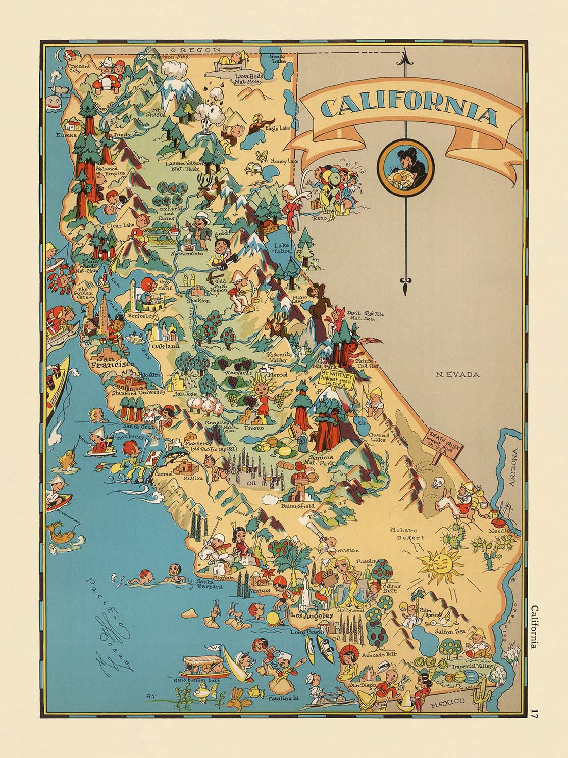
Step into the vibrant world of 1930s California with the captivating pictorial map, originally titled "California," crafted by the talented Ruth Taylor...
Continue readingStep into the vibrant world of 1930s California with the captivating pictorial map, originally titled "California," crafted by the talented Ruth Taylor White in 1935. This map is more than a simple geographic rendering—it is a celebration of California’s regional character, rendered in a whimsical and visually arresting style that reflects the optimism and creative energy of its era. The map’s playful illustrations and lively colors invite viewers to explore the Golden State as it was imagined in popular culture, with each county and region brought to life through charming caricatures and iconic scenes.
Ruth Taylor White, the creative force behind this work, was renowned for her ability to blend artistry with cartography, producing maps that were as entertaining as they were informative. Her pictorial maps became beloved cultural artifacts, capturing the spirit of American regions through a unique lens that combined humor, history, and local color. In this map of California, White’s talent shines through in every detail, from the bustling agricultural valleys to the dramatic peaks of the Sierra Nevada, each vignette thoughtfully chosen to reflect the identity and heritage of the state.
The map’s design is a masterclass in the pictorial style that flourished in the early twentieth century. Rather than relying on strict cartographic conventions, White’s approach is imaginative and narrative-driven, using vibrant illustrations to highlight the industries, landmarks, and cultural traditions that defined California in the 1930s. National treasures such as Yosemite and Sequoia National Parks are depicted with grandeur, while the Pacific coastline teems with maritime activity and sun-drenched beaches. The agricultural abundance of the Central Valley, the gold-laden Sierra foothills, and the storied vineyards of Napa and Sonoma are all vividly rendered, offering a delightful visual journey across the state.
Beyond its aesthetic appeal, this map is a fascinating historical document. It captures a moment in time when California was rapidly evolving, shaped by waves of migration, economic opportunity, and cultural innovation. The map’s illustrations reference the Gold Rush, Spanish missions, Native American heritage, and the burgeoning film industry in Hollywood, providing a layered narrative of the state’s past and present. These themes are woven seamlessly into the landscape, inviting viewers to reflect on the diverse influences that have shaped California’s unique identity.
The map’s depiction of cities and towns, from the burgeoning metropolis of Los Angeles to the storied streets of San Francisco and the agricultural heartland of Fresno, underscores the dynamic growth and regional diversity of California. Each settlement is nestled among distinctive local features—oil derricks in the south, redwood forests in the north, and citrus groves in the sunlit valleys—creating a lively tableau that celebrates both natural beauty and human achievement. This map is not only a visual feast but also a testament to the enduring allure and complexity of California, making it a treasured addition to any collection of historic cartography.
Cities and towns on this map
- Los Angeles
- San Diego
- San Jose
- San Francisco
- Fresno
- Sacramento
- Long Beach
- Oakland
- Bakersfield
- Anaheim
- Santa Ana
- Riverside
- Stockton
- Chula Vista
- Irvine
- Fremont
- San Bernardino
- Modesto
- Oxnard
- Fontana
Notable Features & Landmarks
- Yosemite National Park (depicted with illustrations of waterfalls and granite cliffs)
- Sequoia National Park (shown with giant trees)
- Mount Whitney (illustrated as the highest peak in the contiguous United States)
- The Sierra Nevada mountain range (depicted along the eastern part of the state)
- The Pacific Ocean (bordering the western edge of the map, with illustrations of ships and marine life)
- Agricultural scenes in the Central Valley (depicting crops and farm workers)
- Gold mining imagery in the Sierra foothills (referencing the California Gold Rush)
- Vineyards and wine-making in the Napa/Sonoma region
- Cattle ranching in the Central and Southern regions
- Citrus groves in Southern California
- Hollywood imagery (depicting the film industry)
- Surfing and beach scenes along the southern coast
- Missions (illustrated along the historic El Camino Real)
- Oil derricks in the southern part of the state
- Redwood forests in the northern coastal region
- Grapes and fruit orchards in the San Joaquin Valley
- Depictions of Native American life and culture
- Illustrations of Spanish heritage and influence
- Maritime activities along the coast (fishing, shipping)
- Illustrations of the desert landscape in southeastern California
Historical and design context
- Created by Ruth Taylor White in 1935, a renowned pictorial mapmaker celebrated for blending artistry and cartography.
- Features a whimsical, cartoon-like pictorial style typical of 1930s maps, emphasizing regional character and humor.
- Showcases stereotypical scenes and iconic imagery representative of California’s culture, economy, and landscape during the 1930s.
- Serves as both a geographic representation and a cultural artifact, reflecting the artistic trends and societal attitudes of its era.
- Covers the entire state of California, with county boundaries and notable regions illustrated in a lively, engaging manner.
- Part of a broader pictorial atlas series, capturing the spirit and diversity of American regions for popular audiences.
- Offers a snapshot of California’s history, including references to the Gold Rush, Spanish missions, and the rise of Hollywood.
- Exemplifies the pictorial map movement, blending art and geography for educational and decorative purposes.
Please double check the images to make sure that a specific town or place is shown on this map. You can also get in touch and ask us to check the map for you.
This map looks great at every size, but I always recommend going for a larger size if you have space. That way you can easily make out all of the details.
This map looks amazing at sizes all the way up to 50in (125cm). If you are looking for a larger map, please get in touch.
The model in the listing images is holding the 18x24in (45x60cm) version of this map.
The fifth listing image shows an example of my map personalisation service.
If you’re looking for something slightly different, check out my collection of the best old maps to see if something else catches your eye.
Please contact me to check if a certain location, landmark or feature is shown on this map.
This would make a wonderful birthday, Christmas, Father's Day, work leaving, anniversary or housewarming gift for someone from the areas covered by this map.
This map is available as a giclée print on acid free archival matte paper, or you can buy it framed. The frame is a nice, simple black frame that suits most aesthetics. Please get in touch if you'd like a different frame colour or material. My frames are glazed with super-clear museum-grade acrylic (perspex/acrylite), which is significantly less reflective than glass, safer, and will always arrive in perfect condition.
This map is also available as a float framed canvas, sometimes known as a shadow gap framed canvas or canvas floater. The map is printed on artist's cotton canvas and then stretched over a handmade box frame. We then "float" the canvas inside a wooden frame, which is available in a range of colours (black, dark brown, oak, antique gold and white). This is a wonderful way to present a map without glazing in front. See some examples of float framed canvas maps and explore the differences between my different finishes.
For something truly unique, this map is also available in "Unique 3D", our trademarked process that dramatically transforms the map so that it has a wonderful sense of depth. We combine the original map with detailed topography and elevation data, so that mountains and the terrain really "pop". For more info and examples of 3D maps, check my Unique 3D page.
Step into the vibrant world of 1930s California with the captivating pictorial map, originally titled "California," crafted by the talented Ruth Taylor White in 1935. This map is more than a simple geographic rendering—it is a celebration of California’s regional character, rendered in a whimsical and visually arresting style that reflects the optimism and creative energy of its era. The map’s playful illustrations and lively colors invite viewers to explore the Golden State as it was imagined in popular culture, with each county and region brought to life through charming caricatures and iconic scenes.
Ruth Taylor White, the creative force behind this work, was renowned for her ability to blend artistry with cartography, producing maps that were as entertaining as they were informative. Her pictorial maps became beloved cultural artifacts, capturing the spirit of American regions through a unique lens that combined humor, history, and local color. In this map of California, White’s talent shines through in every detail, from the bustling agricultural valleys to the dramatic peaks of the Sierra Nevada, each vignette thoughtfully chosen to reflect the identity and heritage of the state.
The map’s design is a masterclass in the pictorial style that flourished in the early twentieth century. Rather than relying on strict cartographic conventions, White’s approach is imaginative and narrative-driven, using vibrant illustrations to highlight the industries, landmarks, and cultural traditions that defined California in the 1930s. National treasures such as Yosemite and Sequoia National Parks are depicted with grandeur, while the Pacific coastline teems with maritime activity and sun-drenched beaches. The agricultural abundance of the Central Valley, the gold-laden Sierra foothills, and the storied vineyards of Napa and Sonoma are all vividly rendered, offering a delightful visual journey across the state.
Beyond its aesthetic appeal, this map is a fascinating historical document. It captures a moment in time when California was rapidly evolving, shaped by waves of migration, economic opportunity, and cultural innovation. The map’s illustrations reference the Gold Rush, Spanish missions, Native American heritage, and the burgeoning film industry in Hollywood, providing a layered narrative of the state’s past and present. These themes are woven seamlessly into the landscape, inviting viewers to reflect on the diverse influences that have shaped California’s unique identity.
The map’s depiction of cities and towns, from the burgeoning metropolis of Los Angeles to the storied streets of San Francisco and the agricultural heartland of Fresno, underscores the dynamic growth and regional diversity of California. Each settlement is nestled among distinctive local features—oil derricks in the south, redwood forests in the north, and citrus groves in the sunlit valleys—creating a lively tableau that celebrates both natural beauty and human achievement. This map is not only a visual feast but also a testament to the enduring allure and complexity of California, making it a treasured addition to any collection of historic cartography.
Cities and towns on this map
- Los Angeles
- San Diego
- San Jose
- San Francisco
- Fresno
- Sacramento
- Long Beach
- Oakland
- Bakersfield
- Anaheim
- Santa Ana
- Riverside
- Stockton
- Chula Vista
- Irvine
- Fremont
- San Bernardino
- Modesto
- Oxnard
- Fontana
Notable Features & Landmarks
- Yosemite National Park (depicted with illustrations of waterfalls and granite cliffs)
- Sequoia National Park (shown with giant trees)
- Mount Whitney (illustrated as the highest peak in the contiguous United States)
- The Sierra Nevada mountain range (depicted along the eastern part of the state)
- The Pacific Ocean (bordering the western edge of the map, with illustrations of ships and marine life)
- Agricultural scenes in the Central Valley (depicting crops and farm workers)
- Gold mining imagery in the Sierra foothills (referencing the California Gold Rush)
- Vineyards and wine-making in the Napa/Sonoma region
- Cattle ranching in the Central and Southern regions
- Citrus groves in Southern California
- Hollywood imagery (depicting the film industry)
- Surfing and beach scenes along the southern coast
- Missions (illustrated along the historic El Camino Real)
- Oil derricks in the southern part of the state
- Redwood forests in the northern coastal region
- Grapes and fruit orchards in the San Joaquin Valley
- Depictions of Native American life and culture
- Illustrations of Spanish heritage and influence
- Maritime activities along the coast (fishing, shipping)
- Illustrations of the desert landscape in southeastern California
Historical and design context
- Created by Ruth Taylor White in 1935, a renowned pictorial mapmaker celebrated for blending artistry and cartography.
- Features a whimsical, cartoon-like pictorial style typical of 1930s maps, emphasizing regional character and humor.
- Showcases stereotypical scenes and iconic imagery representative of California’s culture, economy, and landscape during the 1930s.
- Serves as both a geographic representation and a cultural artifact, reflecting the artistic trends and societal attitudes of its era.
- Covers the entire state of California, with county boundaries and notable regions illustrated in a lively, engaging manner.
- Part of a broader pictorial atlas series, capturing the spirit and diversity of American regions for popular audiences.
- Offers a snapshot of California’s history, including references to the Gold Rush, Spanish missions, and the rise of Hollywood.
- Exemplifies the pictorial map movement, blending art and geography for educational and decorative purposes.
Please double check the images to make sure that a specific town or place is shown on this map. You can also get in touch and ask us to check the map for you.
This map looks great at every size, but I always recommend going for a larger size if you have space. That way you can easily make out all of the details.
This map looks amazing at sizes all the way up to 50in (125cm). If you are looking for a larger map, please get in touch.
The model in the listing images is holding the 18x24in (45x60cm) version of this map.
The fifth listing image shows an example of my map personalisation service.
If you’re looking for something slightly different, check out my collection of the best old maps to see if something else catches your eye.
Please contact me to check if a certain location, landmark or feature is shown on this map.
This would make a wonderful birthday, Christmas, Father's Day, work leaving, anniversary or housewarming gift for someone from the areas covered by this map.
This map is available as a giclée print on acid free archival matte paper, or you can buy it framed. The frame is a nice, simple black frame that suits most aesthetics. Please get in touch if you'd like a different frame colour or material. My frames are glazed with super-clear museum-grade acrylic (perspex/acrylite), which is significantly less reflective than glass, safer, and will always arrive in perfect condition.
This map is also available as a float framed canvas, sometimes known as a shadow gap framed canvas or canvas floater. The map is printed on artist's cotton canvas and then stretched over a handmade box frame. We then "float" the canvas inside a wooden frame, which is available in a range of colours (black, dark brown, oak, antique gold and white). This is a wonderful way to present a map without glazing in front. See some examples of float framed canvas maps and explore the differences between my different finishes.
For something truly unique, this map is also available in "Unique 3D", our trademarked process that dramatically transforms the map so that it has a wonderful sense of depth. We combine the original map with detailed topography and elevation data, so that mountains and the terrain really "pop". For more info and examples of 3D maps, check my Unique 3D page.
Many of our maps and art prints are chosen as thoughtful gifts for homes, offices, studies and meaningful places.
Choose a framed option for the easiest ready-to-hang gift, or choose an unframed print if the recipient may prefer to select their own frame.
We make orders locally in 23 countries around the world, so gifts can often be produced close to the recipient. This helps them arrive faster, travel more safely, and avoid customs or import duty surprises.
- We can deliver directly to the recipient
- Framed pieces arrive ready to hang
- Unframed prints are carefully packed in a strong protective tube
- Almost every order is made locally, for faster, safer gifting
- 90-day returns give the recipient time to decide
If you are not sure what to choose, please contact us. We can help you pick the right map, size, finish or delivery option.
Most orders are made locally and delivered in around 2–3 working days, depending on the product, size and destination.
We print and frame maps and artwork in 23 countries around the world, so your order is usually made close to you or your recipient. That means faster delivery, less time in transit, and no customs or import duty surprises.
Personalised and customised pieces usually take an extra 1–2 working days, because we prepare your design and send it to you for approval before printing.
Very large framed orders can take a little longer, as they need extra care in production and delivery.
Every order is carefully packaged: unframed prints are sent in a strong protective tube, while framed pieces are securely packed with protective materials around the frame.
If you need your order by a particular date, please contact us before ordering. We’ll check the best production route and delivery option for your location.
Express delivery is available at checkout for most countries. Next-day delivery is available in the UK, US, Singapore and the UAE.
Your order is covered by our 90-day returns policy and 10-year guarantee.
Our standard frame is a gallery-style black ash hardwood frame, with a simple, modern look. It is approximately 20mm (0.8in) wide. You can also view some lovely customer photos of framed maps and art.
We use super-clear acrylic glazing, also known as Perspex or Acrylite, instead of traditional glass. It is lighter, safer, and has lower reflectivity, giving the artwork a clearer, cleaner appearance.
Six standard frame colours are available at no extra cost: black, dark brown, dark grey, oak, white, and antique gold. Custom framing and mounting/matting is also available for customers looking for something more specific.
Most maps, art prints, and illustrations are also available as a framed canvas. We use matte cotton canvas, stretch it over a sustainably sourced wooden box frame, and then float the piece within a wooden outer frame. The finished result is beautifully presented, with no glazing between you and the artwork.
All frames are supplied ready to hang, with either string or brackets fitted to the back. Very large frames will include heavy-duty hanging plates and/or a mounting baton. If you have any questions, please get in touch.
We can also supply old maps and artwork on canvas, foam board, cotton rag, and other materials.
If you would prefer to frame your map or artwork yourself, please read our size guide before ordering.
My maps are extremely high quality reproductions of original maps.
I source original, rare maps from libraries, auction houses and private collections around the world, restore them at my London workshop, and then use specialist giclée inks and printers to create beautiful maps that look even better than the original.
My maps are printed on acid-free archival matte (not glossy) paper that feels very high quality and almost like card. In technical terms the paper weight/thickness is 10mil/200gsm. It's perfect for framing.
I print with Epson ultrachrome giclée UV fade resistant pigment inks - some of the best inks you can find.
I can also make maps on canvas, cotton rag and other exotic materials.
Learn more about The Unique Maps Co.
Map personalisation
If you're looking for the perfect anniversary or housewarming gift, I can personalise your map to make it truly unique. For example, I can add a short message, or highlight an important location, or add your family's coat of arms.
The options are almost infinite. Please see my map personalisation page for some wonderful examples of what's possible.
To order a personalised map, select "personalise your map" before adding it to your basket.
Get in touch if you're looking for more complex customisations and personalisations.
Map ageing
I have been asked hundreds of times over the years by customers if they could buy a map that looks even older.
Well, now you can, by selecting Aged before you add a map to your basket.
All the product photos you see on this page show the map in its Original form. This is what the map looks like today.
If you select Aged, I will age your map by hand, using a special and unique process developed through years of studying old maps, talking to researchers to understand the chemistry of aging paper, and of course... lots of practice!
If you're unsure, stick to the Original colour of the map. If you want something a bit darker and older looking, go for Aged.
If you are not happy with your order for any reason, contact me and I'll get it fixed ASAP, free of charge. Please see my returns and refund policy for more information.
I am very confident you will like your restored map or art print. I have been doing this since 1984. I'm a 5-star Etsy seller. I have sold tens of thousands of maps and art prints and have over 5,000 real 5-star reviews. My work has been featured in interior design magazines, on the BBC, and on the walls of dozens of 5-star hotels.
I use a unique process to restore maps and artwork that is massively time consuming and labour intensive. Hunting down the original maps and illustrations can take months. I use state of the art and eye-wateringly expensive technology to scan and restore them. As a result, I guarantee my maps and art prints are a cut above the rest. I stand by my products and will always make sure you're 100% happy with what you receive.
Almost all of my maps and art prints look amazing at large sizes (200cm, 6.5ft+) and I can frame and deliver them to you as well, via special oversized courier. Contact me to discuss your specific needs.
Or try searching for something!


