


Rare Old OS Map of Cape Wrath & Tongue, Sutherland by Bartholomew, 1901: Ben Hope, Loch Eriboll, Kyle of Durness, Ben Loyal
20% off 2 — 33% off 3
Add any two eligible items to your bag to receive 20% off. Add a third and it will be complimentary (equivalent to 33% off when purchasing three).
No code needed — the offer applies automatically at checkout.
Valid on all standard maps and fine art prints. You can mix and match any designs.
If you’d like to ship items to multiple addresses, please contact us before placing your order.
Custom and bespoke commissions are excluded.
Contact us if you have any questions
 Designed in London Made in the USA
Designed in London • Made in the USA
Designed in London Made in the USA
Designed in London • Made in the USA

Restored from the original 1901 map and printed to museum-grade archival standards. Read the story behind this map
Choose your size
Choose your finish


(More info)
Gift message & custom finish

If you want to add a gift message, or a finish (jigsaw, aluminium board, etc.) that is not available here, please request it in the "order note" when you check out.
Every order is custom made, so if you need the size adjusted slightly, or printed on an unusual material, just let us know. We've done thousands of custom orders over the years, so there's (almost) nothing we can't manage.
You can also contact us before you order, if you prefer!

- Made locally for fast, safe delivery
- No import duty or hidden fees
- Need advice? Call us or message on WhatsApp
Own a piece of history
8,000+ five-star reviews


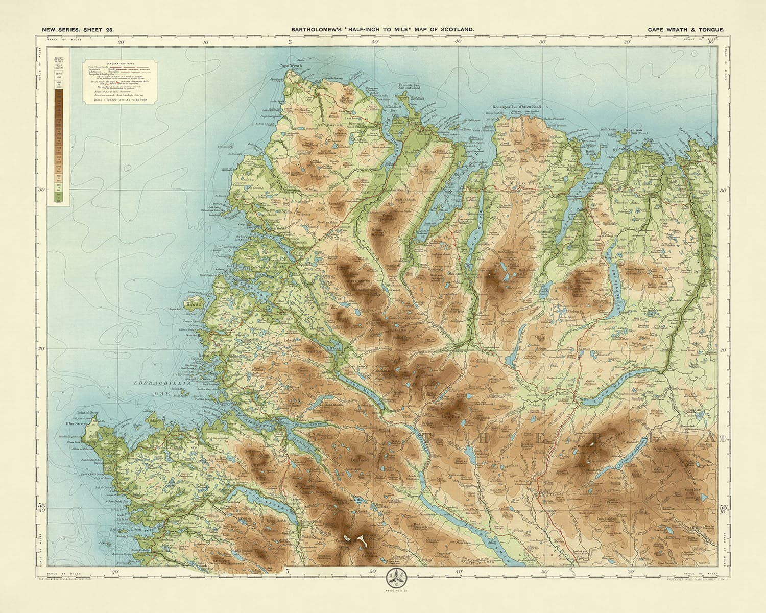
Step back in time with the exquisite "Sheet 26 - Cape Wrath & Tongue," a masterpiece crafted by the renowned cartographer JG...
Continue readingStep back in time with the exquisite "Sheet 26 - Cape Wrath & Tongue," a masterpiece crafted by the renowned cartographer JG Bartholomew in 1901. This map, part of Bartholomew's flagship series, was a beacon for cyclists and tourists of the early 20th century, offering a half-inch to the mile scale (1:126,720) that meticulously detailed the rugged beauty of Scotland's northwestern coast. Bartholomew, often hailed as "the Prince of Cartography," employed innovative techniques to bring this region to life, using a subtle gradation of colour bands to represent the varied landscape relief, making this map not only a navigational tool but also a work of art.
The map’s design is a testament to Bartholomew's cartographic prowess, featuring a landscape orientation that captures 36 miles from north to south and 52 miles from west to east. The use of different layers of colour to indicate elevations and landscape relief is both functional and visually appealing, providing a clear and attractive representation of the terrain. This method allowed users to easily discern the heights of mountains and the depths of valleys, enhancing their understanding of the physical geography. The clarity and aesthetic appeal of this map made it a favourite among those who explored the great outdoors, whether by bicycle or on foot.
"Sheet 26 - Cape Wrath & Tongue" is rich with geographical features that paint a vivid picture of the region. From the imposing peaks of Ben Hope and Ben Loyal to the serene waters of Loch Eriboll and Loch Naver, the map showcases the diverse natural beauty of the area. The Kyle of Durness and Kyle of Tongue are prominently displayed, along with the intricate coastline of Eddrachillis Bay. Rivers such as the Naver, Borgie, Hope, Dionard, and Laxford wind their way through the landscape, adding to the map's detailed depiction of the region's hydrology. These features not only served as crucial navigational aids but also highlighted the stunning natural phenomena that characterized this part of Scotland.
The map also provides a window into the human geography of the time, with towns like Durness, Tongue, Scourie, and Kinlochbervie marked with precision. These settlements, nestled amidst the dramatic landscape, offer a glimpse into the lives of those who inhabited this remote part of the British Isles. The inclusion of these towns, along with smaller villages and hamlets, reflects the map's utility for both local residents and visitors. Each place name is a reminder of the rich cultural and historical tapestry of the region, inviting exploration and discovery.
Historically, this map is significant not only for its cartographic excellence but also for its role in promoting outdoor recreation. At a time when cycling and hiking were becoming popular pastimes, Bartholomew's maps provided essential guidance and inspiration. The detailed political boundaries and physical features captured in "Sheet 26 - Cape Wrath & Tongue" made it an invaluable resource for adventurers and scholars alike. Today, it stands as a beautiful and informative relic of a bygone era, offering a fascinating glimpse into the geography and history of Scotland's wild and captivating northwest.
Cities and towns on this map
- Durness
- Tongue
- Scourie
- Kinlochbervie
- Lairg
- Altnaharra
- Bettyhill
- Strathy
- Melvich
- Rogart
- Golspie
- Brora
Notable Features & Landmarks
- Cape Wrath
- Loch Eriboll
- Loch Hope
- Loch Loyal
- Loch Naver
- Loch Shin
- Loch Stack
- Loch More
- Kyle of Durness
- Kyle of Tongue
- Eddrachillis Bay
- Foinaven (mountain)
- Ben Hope (mountain)
- Ben Loyal (mountain)
- Ben Klibreck (mountain)
- River Naver
- River Borgie
- River Hope
- River Dionard
- River Laxford
Historical and design context
- Name of the map: Sheet 26 - Cape Wrath & Tongue
- Scale: Half-inch to the mile (1:126,720)
- Popularity: These maps were popular with cyclists and tourists, becoming Bartholomew's flagship series.
- Relief Representation: The half-inch maps are distinctive for using different layers of colour to represent landscape relief, with a subtle and innovative gradation of colour bands used to show land at different heights.
- Base Map: The map is based on a reduced Ordnance Survey map from the same period.
- Dimensions: Covers 36 miles from north to south and 52 miles from west to east.
- Creation Date: 1901
- Mapmaker/Publisher: JG Bartholomew
- Interesting Context: John George Bartholomew was a notable Scottish cartographer and geographer, often referred to as "the Prince of Cartography." His work significantly contributed to the development of modern cartographic techniques.
- Themes Shown on the Map:
- Political Boundaries: Shows detailed political boundaries within the region.
- Physical Features: Highlights physical geography, including mountains, rivers, and coastal features.
- Tourism and Cycling: Designed to be useful for cyclists and tourists, indicating routes and points of interest.
- Countries and Regions Shown:
- Scotland: Specifically the northwestern part, including Cape Wrath and Tongue.
- Design and Style:
- Landscape Orientation: The map is laid out in landscape format.
- Colour Gradation: Uses a gradation of colours to indicate different elevations and landscape relief.
- Clarity and Attractiveness: Known for its clear and attractive presentation.
- Historical Significance:
- Innovative Cartography: Represents a significant advancement in the use of colour and relief in maps.
- Tourism and Recreation: Reflects the growing popularity of outdoor activities like cycling and hiking in the early 20th century.
Please double check the images to make sure that a specific town or place is shown on this map. You can also get in touch and ask us to check the map for you.
This map looks great at every size, but I always recommend going for a larger size if you have space. That way you can easily make out all of the details.
This map looks amazing at sizes all the way up to 70in (180cm). If you are looking for a larger map, please get in touch.
Please note: the labels on this map are hard to read if you order a map that is 20in (50cm) or smaller. The map is still very attractive, but if you would like to read the map easily, please buy a larger size.
The model in the listing images is holding the 16x20in (40x50cm) version of this map.
The fifth listing image shows an example of my map personalisation service.
If you’re looking for something slightly different, check out my collection of the best old maps to see if something else catches your eye.
Please contact me to check if a certain location, landmark or feature is shown on this map.
This would make a wonderful birthday, Christmas, Father's Day, work leaving, anniversary or housewarming gift for someone from the areas covered by this map.
This map is available as a giclée print on acid free archival matte paper, or you can buy it framed. The frame is a nice, simple black frame that suits most aesthetics. Please get in touch if you'd like a different frame colour or material. My frames are glazed with super-clear museum-grade acrylic (perspex/acrylite), which is significantly less reflective than glass, safer, and will always arrive in perfect condition.
This map is also available as a float framed canvas, sometimes known as a shadow gap framed canvas or canvas floater. The map is printed on artist's cotton canvas and then stretched over a handmade box frame. We then "float" the canvas inside a wooden frame, which is available in a range of colours (black, dark brown, oak, antique gold and white). This is a wonderful way to present a map without glazing in front. See some examples of float framed canvas maps and explore the differences between my different finishes.
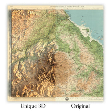
For something truly unique, this map is also available in "Unique 3D", our trademarked process that dramatically transforms the map so that it has a wonderful sense of depth. We combine the original map with detailed topography and elevation data, so that mountains and the terrain really "pop". For more info and examples of 3D maps, check my Unique 3D page.
Step back in time with the exquisite "Sheet 26 - Cape Wrath & Tongue," a masterpiece crafted by the renowned cartographer JG Bartholomew in 1901. This map, part of Bartholomew's flagship series, was a beacon for cyclists and tourists of the early 20th century, offering a half-inch to the mile scale (1:126,720) that meticulously detailed the rugged beauty of Scotland's northwestern coast. Bartholomew, often hailed as "the Prince of Cartography," employed innovative techniques to bring this region to life, using a subtle gradation of colour bands to represent the varied landscape relief, making this map not only a navigational tool but also a work of art.
The map’s design is a testament to Bartholomew's cartographic prowess, featuring a landscape orientation that captures 36 miles from north to south and 52 miles from west to east. The use of different layers of colour to indicate elevations and landscape relief is both functional and visually appealing, providing a clear and attractive representation of the terrain. This method allowed users to easily discern the heights of mountains and the depths of valleys, enhancing their understanding of the physical geography. The clarity and aesthetic appeal of this map made it a favourite among those who explored the great outdoors, whether by bicycle or on foot.
"Sheet 26 - Cape Wrath & Tongue" is rich with geographical features that paint a vivid picture of the region. From the imposing peaks of Ben Hope and Ben Loyal to the serene waters of Loch Eriboll and Loch Naver, the map showcases the diverse natural beauty of the area. The Kyle of Durness and Kyle of Tongue are prominently displayed, along with the intricate coastline of Eddrachillis Bay. Rivers such as the Naver, Borgie, Hope, Dionard, and Laxford wind their way through the landscape, adding to the map's detailed depiction of the region's hydrology. These features not only served as crucial navigational aids but also highlighted the stunning natural phenomena that characterized this part of Scotland.
The map also provides a window into the human geography of the time, with towns like Durness, Tongue, Scourie, and Kinlochbervie marked with precision. These settlements, nestled amidst the dramatic landscape, offer a glimpse into the lives of those who inhabited this remote part of the British Isles. The inclusion of these towns, along with smaller villages and hamlets, reflects the map's utility for both local residents and visitors. Each place name is a reminder of the rich cultural and historical tapestry of the region, inviting exploration and discovery.
Historically, this map is significant not only for its cartographic excellence but also for its role in promoting outdoor recreation. At a time when cycling and hiking were becoming popular pastimes, Bartholomew's maps provided essential guidance and inspiration. The detailed political boundaries and physical features captured in "Sheet 26 - Cape Wrath & Tongue" made it an invaluable resource for adventurers and scholars alike. Today, it stands as a beautiful and informative relic of a bygone era, offering a fascinating glimpse into the geography and history of Scotland's wild and captivating northwest.
Cities and towns on this map
- Durness
- Tongue
- Scourie
- Kinlochbervie
- Lairg
- Altnaharra
- Bettyhill
- Strathy
- Melvich
- Rogart
- Golspie
- Brora
Notable Features & Landmarks
- Cape Wrath
- Loch Eriboll
- Loch Hope
- Loch Loyal
- Loch Naver
- Loch Shin
- Loch Stack
- Loch More
- Kyle of Durness
- Kyle of Tongue
- Eddrachillis Bay
- Foinaven (mountain)
- Ben Hope (mountain)
- Ben Loyal (mountain)
- Ben Klibreck (mountain)
- River Naver
- River Borgie
- River Hope
- River Dionard
- River Laxford
Historical and design context
- Name of the map: Sheet 26 - Cape Wrath & Tongue
- Scale: Half-inch to the mile (1:126,720)
- Popularity: These maps were popular with cyclists and tourists, becoming Bartholomew's flagship series.
- Relief Representation: The half-inch maps are distinctive for using different layers of colour to represent landscape relief, with a subtle and innovative gradation of colour bands used to show land at different heights.
- Base Map: The map is based on a reduced Ordnance Survey map from the same period.
- Dimensions: Covers 36 miles from north to south and 52 miles from west to east.
- Creation Date: 1901
- Mapmaker/Publisher: JG Bartholomew
- Interesting Context: John George Bartholomew was a notable Scottish cartographer and geographer, often referred to as "the Prince of Cartography." His work significantly contributed to the development of modern cartographic techniques.
- Themes Shown on the Map:
- Political Boundaries: Shows detailed political boundaries within the region.
- Physical Features: Highlights physical geography, including mountains, rivers, and coastal features.
- Tourism and Cycling: Designed to be useful for cyclists and tourists, indicating routes and points of interest.
- Countries and Regions Shown:
- Scotland: Specifically the northwestern part, including Cape Wrath and Tongue.
- Design and Style:
- Landscape Orientation: The map is laid out in landscape format.
- Colour Gradation: Uses a gradation of colours to indicate different elevations and landscape relief.
- Clarity and Attractiveness: Known for its clear and attractive presentation.
- Historical Significance:
- Innovative Cartography: Represents a significant advancement in the use of colour and relief in maps.
- Tourism and Recreation: Reflects the growing popularity of outdoor activities like cycling and hiking in the early 20th century.
Please double check the images to make sure that a specific town or place is shown on this map. You can also get in touch and ask us to check the map for you.
This map looks great at every size, but I always recommend going for a larger size if you have space. That way you can easily make out all of the details.
This map looks amazing at sizes all the way up to 70in (180cm). If you are looking for a larger map, please get in touch.
Please note: the labels on this map are hard to read if you order a map that is 20in (50cm) or smaller. The map is still very attractive, but if you would like to read the map easily, please buy a larger size.
The model in the listing images is holding the 16x20in (40x50cm) version of this map.
The fifth listing image shows an example of my map personalisation service.
If you’re looking for something slightly different, check out my collection of the best old maps to see if something else catches your eye.
Please contact me to check if a certain location, landmark or feature is shown on this map.
This would make a wonderful birthday, Christmas, Father's Day, work leaving, anniversary or housewarming gift for someone from the areas covered by this map.
This map is available as a giclée print on acid free archival matte paper, or you can buy it framed. The frame is a nice, simple black frame that suits most aesthetics. Please get in touch if you'd like a different frame colour or material. My frames are glazed with super-clear museum-grade acrylic (perspex/acrylite), which is significantly less reflective than glass, safer, and will always arrive in perfect condition.
This map is also available as a float framed canvas, sometimes known as a shadow gap framed canvas or canvas floater. The map is printed on artist's cotton canvas and then stretched over a handmade box frame. We then "float" the canvas inside a wooden frame, which is available in a range of colours (black, dark brown, oak, antique gold and white). This is a wonderful way to present a map without glazing in front. See some examples of float framed canvas maps and explore the differences between my different finishes.
For something truly unique, this map is also available in "Unique 3D", our trademarked process that dramatically transforms the map so that it has a wonderful sense of depth. We combine the original map with detailed topography and elevation data, so that mountains and the terrain really "pop". For more info and examples of 3D maps, check my Unique 3D page.
Many of our maps and art prints are chosen as thoughtful gifts for homes, offices, studies and meaningful places.
Choose a framed option for the easiest ready-to-hang gift, or choose an unframed print if the recipient may prefer to select their own frame.
We make orders locally in 23 countries around the world, so gifts can often be produced close to the recipient. This helps them arrive faster, travel more safely, and avoid customs or import duty surprises.
- We can deliver directly to the recipient
- Framed pieces arrive ready to hang
- Unframed prints are carefully packed in a strong protective tube
- Almost every order is made locally, for faster, safer gifting
- 90-day returns give the recipient time to decide
If you are not sure what to choose, please contact us. We can help you pick the right map, size, finish or delivery option.
Most orders are made locally and delivered in around 2–3 working days, depending on the product, size and destination.
We print and frame maps and artwork in 23 countries around the world, so your order is usually made close to you or your recipient. That means faster delivery, less time in transit, and no customs or import duty surprises.
Personalised and customised pieces usually take an extra 1–2 working days, because we prepare your design and send it to you for approval before printing.
Very large framed orders can take a little longer, as they need extra care in production and delivery.
Every order is carefully packaged: unframed prints are sent in a strong protective tube, while framed pieces are securely packed with protective materials around the frame.
If you need your order by a particular date, please contact us before ordering. We’ll check the best production route and delivery option for your location.
Express delivery is available at checkout for most countries. Next-day delivery is available in the UK, US, Singapore and the UAE.
Your order is covered by our 90-day returns policy and 10-year guarantee.
Our standard frame is a gallery-style black ash hardwood frame, with a simple, modern look. It is approximately 20mm (0.8in) wide. You can also view some lovely customer photos of framed maps and art.
We use super-clear acrylic glazing, also known as Perspex or Acrylite, instead of traditional glass. It is lighter, safer, and has lower reflectivity, giving the artwork a clearer, cleaner appearance.
Six standard frame colours are available at no extra cost: black, dark brown, dark grey, oak, white, and antique gold. Custom framing and mounting/matting is also available for customers looking for something more specific.
Most maps, art prints, and illustrations are also available as a framed canvas. We use matte cotton canvas, stretch it over a sustainably sourced wooden box frame, and then float the piece within a wooden outer frame. The finished result is beautifully presented, with no glazing between you and the artwork.
All frames are supplied ready to hang, with either string or brackets fitted to the back. Very large frames will include heavy-duty hanging plates and/or a mounting baton. If you have any questions, please get in touch.
We can also supply old maps and artwork on canvas, foam board, cotton rag, and other materials.
If you would prefer to frame your map or artwork yourself, please read our size guide before ordering.
My maps are extremely high quality reproductions of original maps.
I source original, rare maps from libraries, auction houses and private collections around the world, restore them at my London workshop, and then use specialist giclée inks and printers to create beautiful maps that look even better than the original.
My maps are printed on acid-free archival matte (not glossy) paper that feels very high quality and almost like card. In technical terms the paper weight/thickness is 10mil/200gsm. It's perfect for framing.
I print with Epson ultrachrome giclée UV fade resistant pigment inks - some of the best inks you can find.
I can also make maps on canvas, cotton rag and other exotic materials.
Learn more about The Unique Maps Co.
Map personalisation
If you're looking for the perfect anniversary or housewarming gift, I can personalise your map to make it truly unique. For example, I can add a short message, or highlight an important location, or add your family's coat of arms.
The options are almost infinite. Please see my map personalisation page for some wonderful examples of what's possible.
To order a personalised map, select "personalise your map" before adding it to your basket.
Get in touch if you're looking for more complex customisations and personalisations.
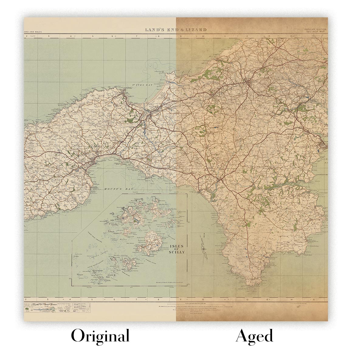
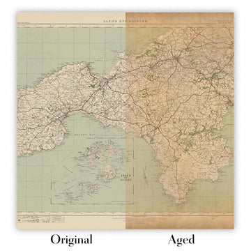
Map ageing
I have been asked hundreds of times over the years by customers if they could buy a map that looks even older.
Well, now you can, by selecting Aged before you add a map to your basket.
All the product photos you see on this page show the map in its Original form. This is what the map looks like today.
If you select Aged, I will age your map by hand, using a special and unique process developed through years of studying old maps, talking to researchers to understand the chemistry of aging paper, and of course... lots of practice!
If you're unsure, stick to the Original colour of the map. If you want something a bit darker and older looking, go for Aged.
If you are not happy with your order for any reason, contact me and I'll get it fixed ASAP, free of charge. Please see my returns and refund policy for more information.
I am very confident you will like your restored map or art print. I have been doing this since 1984. I'm a 5-star Etsy seller. I have sold tens of thousands of maps and art prints and have over 5,000 real 5-star reviews. My work has been featured in interior design magazines, on the BBC, and on the walls of dozens of 5-star hotels.
I use a unique process to restore maps and artwork that is massively time consuming and labour intensive. Hunting down the original maps and illustrations can take months. I use state of the art and eye-wateringly expensive technology to scan and restore them. As a result, I guarantee my maps and art prints are a cut above the rest. I stand by my products and will always make sure you're 100% happy with what you receive.
Almost all of my maps and art prints look amazing at large sizes (200cm, 6.5ft+) and I can frame and deliver them to you as well, via special oversized courier. Contact me to discuss your specific needs.
Or try searching for something!


