

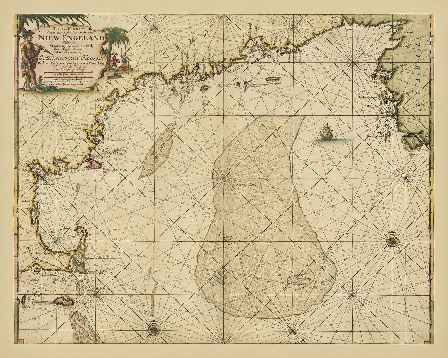


Old New England Nautical Chart by van Keulen, 1695: Cape Cod, Nantucket, Acadia (Nova Scotia)
20% off 2 — 33% off 3
Add any two eligible items to your bag to receive 20% off. Add a third and it will be complimentary (equivalent to 33% off when purchasing three).
No code needed — the offer applies automatically at checkout.
Valid on all standard maps and fine art prints. You can mix and match any designs.
If you’d like to ship items to multiple addresses, please contact us before placing your order.
Custom and bespoke commissions are excluded.
Contact us if you have any questions
 Designed in London Made in the USA
Designed in London • Made in the USA
Designed in London Made in the USA
Designed in London • Made in the USA

Choose your size
Choose your finish


(More info)
Gift message & custom finish

If you want to add a gift message, or a finish (jigsaw, aluminium board, etc.) that is not available here, please request it in the "order note" when you check out.
Every order is custom made, so if you need the size adjusted slightly, or printed on an unusual material, just let us know. We've done thousands of custom orders over the years, so there's (almost) nothing we can't manage.
You can also contact us before you order, if you prefer!

- Made locally for fast, safe delivery
- No import duty or hidden fees
- Need advice? Message us on WhatsApp
Own a piece of history
7,000+ 5 star reviews


Step into the golden age of maritime exploration with this exquisite Dutch sea chart, “[Cape Cod to Acadia] Pas-Kaart Vande Zee Kusten inde boght van Niew Engeland Tusschen de Staaten Hoek en C.de Sable,” crafted by the renowned cartographer Johannes van Keulen in 1695. This remarkable nautical chart captures the intricate coastline of New England, stretching from the windswept sands of Cape Cod and the storied island of Nantucket, through the bustling harbors of Plymouth and Boston, and onward to the rugged shores of Acadia (Nova Scotia). Designed for the discerning navigator, this map is a testament to the era’s relentless quest for accuracy and detail, revealing the maritime arteries that shaped early transatlantic trade and colonial expansion.
The map’s primary focus is on the coastal geography and navigational hazards of the North Atlantic seaboard, meticulously rendered through a series of infographics that would have been indispensable to 17th-century mariners. Soundings, indicated by clusters of numbers in fathoms, trace the shifting depths of the sea, guiding ships safely past treacherous shoals and sandbanks. The presence of these soundings, along with detailed depictions of currents, channels, and underwater obstructions, speaks to the practical utility and advanced hydrographic knowledge embodied in van Keulen’s work.
A masterwork of Dutch cartographic artistry, this chart is further distinguished by its ornate compass rose and decorative cartouche, hallmarks of the van Keulen publishing house. The compass rose not only orients the viewer but also serves as a visual anchor, symbolizing the navigational prowess of the Dutch during their golden age of exploration. The map’s elegant design, blending scientific precision with artistic flourish, reflects the broader tradition of Amsterdam’s mapmakers, who set the standard for marine cartography in the 17th century.
Each named harbor, from Boston to Plymouth, and every carefully plotted shoal or island, tells a story of risk, discovery, and the vital importance of accurate information in a world where the sea was both highway and hazard. The inclusion of lesser-known coastal settlements and the evolving depiction of shoals—updated in successive editions—demonstrates the dynamic nature of early modern mapmaking, where charts were living documents, continually refined as new knowledge emerged from the voyages they enabled.
Owning this map is not merely acquiring a piece of maritime history; it is an invitation to trace the routes of early explorers and merchants, to appreciate the blend of art and science that defined the Dutch cartographic tradition, and to glimpse the world as it appeared to those who first charted these waters. For collectors and connoisseurs of historical maps, this chart is a rare and essential artifact—an enduring symbol of exploration, craftsmanship, and the enduring allure of the unknown.
Notable places on this map
- Cape Cod (C. Cod)
- Nantucket Island (Natoket)
- Boston Harbor
- Plymouth Harbor
- Cape Sable (C. de Sable) at the northeastern extent of the map
- Various unnamed coastal settlements and harbors along the New England coast
- Shoals and sandbanks southwest of Nantucket and extending from Cape Sable
- The general region of Acadia (Nova Scotia)
- The Staaten Hoek (Staten Hook), marking the southwestern extent of the map
- Numerous small islands and coastal features along the depicted shoreline
Notable Features & Landmarks
- The coastline of New England from Cape Cod to Acadia (Nova Scotia), including detailed renderings of bays, inlets, and islands
- Numerous soundings (numbers indicating water depths in fathoms) scattered throughout the coastal waters
- Shoals and sandbanks depicted, especially around Nantucket and Cape Cod, with new shoals added in later editions
- A large, ornate compass rose for navigational reference
- Coastal settlements and harbors marked, with some named directly on the map
- Decorative cartouche and embellishments typical of Dutch sea charts of the era
- The map is oriented with north at the top, as indicated by the compass rose
Historical and design context
- Crafted by Johannes van Keulen, a prominent Dutch cartographer and publisher known for his influential nautical atlases and charts in the late 17th and early 18th centuries
- Date of creation: 1695 (with earlier editions first published in 1684, and subsequent updates in 1687 and later)
- One of the earliest and most detailed obtainable coastal charts of New England; considered essential for collectors of regional cartography and maritime history
- Johannes van Keulen’s Zee-Fakkel was a landmark in marine cartography, and his charts played a key role in the development of navigation and trade in the North Atlantic
- Typical of late 17th-century Dutch sea charts, with decorative elements, compass roses, and detailed hydrographic information for navigation
- Notable changes in successive editions include the addition of shoals, numbering in the corners, and updates to navigational features, reflecting evolving knowledge of the coastline
Please double check the images to make sure that a specific town or place is shown on this map. You can also get in touch and ask us to check the map for you.
This map looks great at every size, but I always recommend going for a larger size if you have space. That way you can easily make out all of the details.
This map looks amazing at sizes all the way up to 100in (250cm). If you are looking for a larger map, please get in touch.
The model in the listing images is holding the 16x20in (40x50cm) version of this map.
The fifth listing image shows an example of my map personalisation service.
If you’re looking for something slightly different, check out my collection of the best old maps to see if something else catches your eye.
Please contact me to check if a certain location, landmark or feature is shown on this map.
This would make a wonderful birthday, Christmas, Father's Day, work leaving, anniversary or housewarming gift for someone from the areas covered by this map.
This map is available as a giclée print on acid free archival matte paper, or you can buy it framed. The frame is a nice, simple black frame that suits most aesthetics. Please get in touch if you'd like a different frame colour or material. My frames are glazed with super-clear museum-grade acrylic (perspex/acrylite), which is significantly less reflective than glass, safer, and will always arrive in perfect condition.
This map is also available as a float framed canvas, sometimes known as a shadow gap framed canvas or canvas floater. The map is printed on artist's cotton canvas and then stretched over a handmade box frame. We then "float" the canvas inside a wooden frame, which is available in a range of colours (black, dark brown, oak, antique gold and white). This is a wonderful way to present a map without glazing in front. See some examples of float framed canvas maps and explore the differences between my different finishes.
For something truly unique, this map is also available in "Unique 3D", our trademarked process that dramatically transforms the map so that it has a wonderful sense of depth. We combine the original map with detailed topography and elevation data, so that mountains and the terrain really "pop". For more info and examples of 3D maps, check my Unique 3D page.
Many of our maps and art prints are chosen as thoughtful gifts for homes, offices, studies and meaningful places.
Choose a framed option for the easiest ready-to-hang gift, or choose an unframed print if the recipient may prefer to select their own frame.
We make orders locally in 23 countries around the world, so gifts can often be produced close to the recipient. This helps them arrive faster, travel more safely, and avoid customs or import duty surprises.
- We can deliver directly to the recipient
- Framed pieces arrive ready to hang
- Unframed prints are carefully packed in a strong protective tube
- Almost every order is made locally, for faster, safer gifting
- 90-day returns give the recipient time to decide
If you are not sure what to choose, please contact us. We can help you pick the right map, size, finish or delivery option.
Most orders are made locally and delivered in around 2–3 working days, depending on the product, size and destination.
We print and frame maps and artwork in 23 countries around the world, so your order is usually made close to you or your recipient. That means faster delivery, less time in transit, and no customs or import duty surprises.
Personalised and customised pieces usually take an extra 1–2 working days, because we prepare your design and send it to you for approval before printing.
Very large framed orders can take a little longer, as they need extra care in production and delivery.
Every order is carefully packaged: unframed prints are sent in a strong protective tube, while framed pieces are securely packed with protective materials around the frame.
If you need your order by a particular date, please contact us before ordering. We’ll check the best production route and delivery option for your location.
Express delivery is available at checkout for most countries. Next-day delivery is available in the UK, US, Singapore and the UAE.
Your order is covered by our 90-day returns policy and 10-year guarantee.
Our standard frame is a gallery-style black ash hardwood frame, with a simple, modern look. It is approximately 20mm (0.8in) wide. You can also view some lovely customer photos of framed maps and art.
We use super-clear acrylic glazing, also known as Perspex or Acrylite, instead of traditional glass. It is lighter, safer, and has lower reflectivity, giving the artwork a clearer, cleaner appearance.
Six standard frame colours are available at no extra cost: black, dark brown, dark grey, oak, white, and antique gold. Custom framing and mounting/matting is also available for customers looking for something more specific.
Most maps, art prints, and illustrations are also available as a framed canvas. We use matte cotton canvas, stretch it over a sustainably sourced wooden box frame, and then float the piece within a wooden outer frame. The finished result is beautifully presented, with no glazing between you and the artwork.
All frames are supplied ready to hang, with either string or brackets fitted to the back. Very large frames will include heavy-duty hanging plates and/or a mounting baton. If you have any questions, please get in touch.
We can also supply old maps and artwork on canvas, foam board, cotton rag, and other materials.
If you would prefer to frame your map or artwork yourself, please read our size guide before ordering.
My maps are extremely high quality reproductions of original maps.
I source original, rare maps from libraries, auction houses and private collections around the world, restore them at my London workshop, and then use specialist giclée inks and printers to create beautiful maps that look even better than the original.
My maps are printed on acid-free archival matte (not glossy) paper that feels very high quality and almost like card. In technical terms the paper weight/thickness is 10mil/200gsm. It's perfect for framing.
I print with Epson ultrachrome giclée UV fade resistant pigment inks - some of the best inks you can find.
I can also make maps on canvas, cotton rag and other exotic materials.
Learn more about The Unique Maps Co.
Map personalisation
If you're looking for the perfect anniversary or housewarming gift, I can personalise your map to make it truly unique. For example, I can add a short message, or highlight an important location, or add your family's coat of arms.
The options are almost infinite. Please see my map personalisation page for some wonderful examples of what's possible.
To order a personalised map, select "personalise your map" before adding it to your basket.
Get in touch if you're looking for more complex customisations and personalisations.
Map ageing
I have been asked hundreds of times over the years by customers if they could buy a map that looks even older.
Well, now you can, by selecting Aged before you add a map to your basket.
All the product photos you see on this page show the map in its Original form. This is what the map looks like today.
If you select Aged, I will age your map by hand, using a special and unique process developed through years of studying old maps, talking to researchers to understand the chemistry of aging paper, and of course... lots of practice!
If you're unsure, stick to the Original colour of the map. If you want something a bit darker and older looking, go for Aged.
If you are not happy with your order for any reason, contact me and I'll get it fixed ASAP, free of charge. Please see my returns and refund policy for more information.
I am very confident you will like your restored map or art print. I have been doing this since 1984. I'm a 5-star Etsy seller. I have sold tens of thousands of maps and art prints and have over 5,000 real 5-star reviews. My work has been featured in interior design magazines, on the BBC, and on the walls of dozens of 5-star hotels.
I use a unique process to restore maps and artwork that is massively time consuming and labour intensive. Hunting down the original maps and illustrations can take months. I use state of the art and eye-wateringly expensive technology to scan and restore them. As a result, I guarantee my maps and art prints are a cut above the rest. I stand by my products and will always make sure you're 100% happy with what you receive.
Almost all of my maps and art prints look amazing at large sizes (200cm, 6.5ft+) and I can frame and deliver them to you as well, via special oversized courier. Contact me to discuss your specific needs.
Or try searching for something!


