

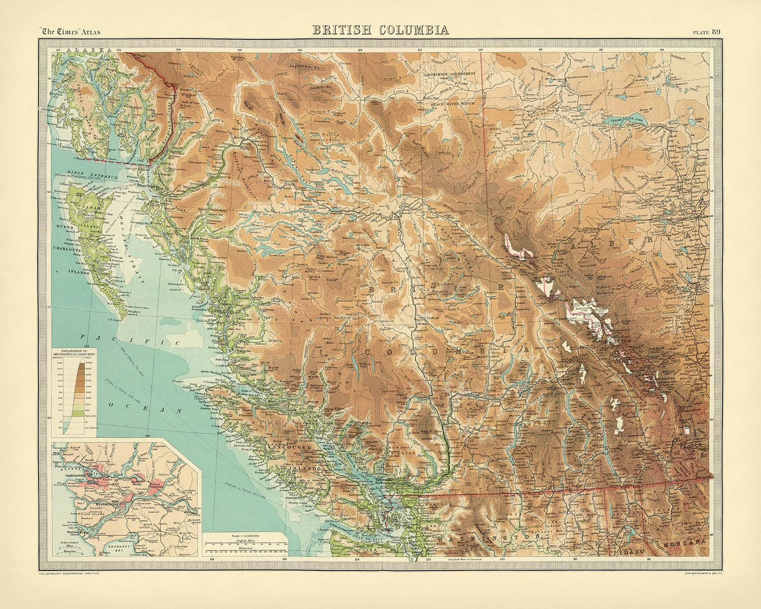


Rare Old Map of Vancouver & British Columbia by Bartholomew, 1922: Victoria, Rocky Mountains, Vancouver Island, Fraser River
The Collector’s Offer
Choose two eligible works and receive 20% off both. Choose three and the lowest-priced one is complimentary, a maximum saving of 33%.
Mix and match eligible standard maps and fine-art prints. No code is required; the offer is applied automatically at checkout.
Standard made-to-order configurations are included. Bespoke sizes, personalised designs and commissioned work are excluded.
Need delivery to different addresses? Contact us before ordering.The Collector’s Offer
Choose two eligible works and receive 20% off both. Choose three and the lowest-priced one is complimentary, a maximum saving of 33%.
Mix and match eligible standard maps and fine-art prints. No code is required; the offer is applied automatically at checkout.
Standard made-to-order configurations are included. Bespoke sizes, personalised designs and commissioned work are excluded.
Need delivery to different addresses? Contact us before ordering. Restored in London • Made in the USA

Restored from the original 1922 map and printed to museum-grade archival standards. Read the story behind this map
Choose your size
Choose your finish


(More info)
Gift message & custom finish

If you want to add a gift message, or a finish (jigsaw, aluminium board, etc.) that is not available here, please request it in the "order note" when you check out.
Every order is custom made, so if you need the size adjusted slightly, or printed on an unusual material, just let us know. We've done thousands of custom orders over the years, so there's (almost) nothing we can't manage.
You can also contact us before you order, if you prefer!

- Made locally for fast, safe delivery
- No import duty or hidden fees
- Need advice? Call us or message on WhatsApp
Own a piece of history
8,000+ five-star reviews


Step into the storied landscapes of Canada’s Pacific frontier with “British Columbia.”, a map crafted in 1922 by the illustrious John George...
Continue readingStep into the storied landscapes of Canada’s Pacific frontier with “British Columbia.”, a map crafted in 1922 by the illustrious John George Bartholomew. Bearing its original title with a period—an elegant touch from the era—this map stands as a testament to the golden age of cartography. Commissioned for the second issue of the 1920 edition of The Times Atlas & Gazetteer of the World, it captures the province at a pivotal moment in its development, when railways, resource towns, and natural wonders were shaping the region’s destiny. The map’s meticulous detail invites viewers to explore the vast and varied terrain of British Columbia, from the rugged Pacific coastline to the snow-capped peaks of the Rocky Mountains.
Bartholomew, often hailed as “the Prince of Cartographers,” brought an unprecedented level of artistry and precision to this work. His innovative use of hypsometric tints—subtle gradations of color to indicate elevation—breathes life into the mountainous spine of the province, while spot heights pinpoint the summits that define its skyline. The map’s bathymetric tints reveal the mysterious depths of the Pacific and the intricate waterways that carve through the land, such as the mighty Fraser and Columbia Rivers. This visual language not only enhances the map’s beauty but also provides an intuitive understanding of British Columbia’s dramatic topography.
A closer examination reveals a province teeming with geographic and historic significance. Vancouver Island and the Queen Charlotte Islands (now Haida Gwaii) are elegantly outlined, while the Cariboo and Kootenay regions—epicenters of gold rushes and mining booms—speak to the province’s adventurous past. The map highlights the labyrinthine network of lakes, including Okanagan and Shuswap, and the vital arteries of commerce and migration, such as the Canadian Pacific Railway. Each feature is rendered with a cartographer’s devotion to accuracy, reflecting Bartholomew’s commitment to both science and art.
Cities and towns are marked with a careful hand, offering a snapshot of British Columbia’s urban evolution. Vancouver, Victoria, and New Westminster anchor the province’s burgeoning metropolitan heart, while smaller settlements like Kamloops, Prince George, and Nelson hint at the waves of settlement and economic activity that defined the early twentieth century. The map’s inset of the Vancouver area, presented at an impressive scale, provides a rare and detailed glimpse into a city on the cusp of modern transformation.
This map is more than a geographical reference—it is a historical artifact, encapsulating the spirit of exploration, enterprise, and natural grandeur that has always defined British Columbia. As part of The Times Atlas’s legacy, it marks a significant transition in the history of mapmaking, with Bartholomew’s vision setting new standards for accuracy and aesthetic appeal. For collectors, historians, or those simply enchanted by the landscapes of the Pacific Northwest, “British Columbia.” offers a window into a world where every mountain, river, and border tells a story.
Cities and towns on this map
- Vancouver
- Surrey
- Burnaby
- Richmond
- Abbotsford
- Coquitlam
- Kelowna
- Nanaimo
- Kamloops
- Victoria
- Chilliwack
- Prince George
- Vernon
- Langley
- Penticton
- Campbell River
- Courtenay
- Powell River
- Nelson
- Cranbrook
- Dawson Creek
- Terrace
- Quesnel
- Williams Lake
- Fort St. John
- Trail
- Kitimat
- Smithers
- Revelstoke
- Fernie
- Golden
- Creston
- Merritt
- Salmon Arm
- Squamish
- Port Alberni
- Parksville
- Sidney
- Kimberley
- Grand Forks
- Castlegar
- Hope
- Lillooet
- Princeton
- Hazelton
- Stewart
- New Westminster
- Esquimalt
- Saanich
- North Vancouver
- West Vancouver
Notable Features & Landmarks
- The Rocky Mountains, prominently depicted with hypsometric tints
- The Coast Mountains, running parallel to the Pacific coastline
- The Columbia River, a major river system in southern British Columbia
- The Fraser River, flowing from the interior to the Pacific Ocean
- Okanagan Lake, a significant inland water body
- Vancouver Island, shown off the southwest coast
- Queen Charlotte Islands (now known as Haida Gwaii), labeled off the northwest coast
- The Strait of Georgia, separating Vancouver Island from the mainland
- Bathymetric shading in the Pacific Ocean and major lakes
- The Cariboo region, historically significant for the Cariboo Gold Rush
- The Kootenay region, known for its mountainous terrain and mining history
- The Skeena River, a major river in northern British Columbia
- The Peace River, flowing in the northeast of the province
- Major railway lines, including the Canadian Pacific Railway
- Provincial boundaries and county/district divisions clearly marked
- Inset map of the Vancouver area for greater detail
- Spot heights marking significant mountain peaks
- The Alaska boundary, showing the border with the United States
- The southern border with the United States (Washington State)
- The presence of several large lakes, such as Shuswap Lake and Arrow Lakes
Historical and design context
- Created in 1922 by John George Bartholomew, a renowned British cartographer known for his innovative techniques and artistry
- Commissioned for the second issue of the 1920 edition of The Times Atlas & Gazetteer of the World
- Marked a significant transition in cartographic sources, replacing maps by Andree from the 1895 edition
- Detailed political and physical map showing county or provincial boundaries, topography, hydrography, and transportation routes
- Employs hypsometric tints (color shading by elevation) and spot heights to depict topographical variations
- Bathymetric tints used to illustrate the depths of water bodies
- Included a page of corrections from the earlier 1920 edition, reflecting a commitment to accuracy and refinement
- Exemplifies early 20th-century cartographic art, with careful attention to color, typography, and geographical accuracy
- Represents a period of transition and advancement in atlas cartography, and is a valuable artifact for collectors and historians
- The Times Atlas series, beginning with this edition, has continued to be a standard reference for global cartography
- Emphasizes both physical geography (mountains, rivers, lakes) and political divisions (counties, districts)
- Notable for its detailed depiction of natural features and transportation infrastructure as of the early 1920s
Please double check the images to make sure that a specific town or place is shown on this map. You can also get in touch and ask us to check the map for you.
This map looks great at every size, but I always recommend going for a larger size if you have space. That way you can easily make out all of the details.
This map looks amazing at sizes all the way up to 70in (180cm). If you are looking for a larger map, please get in touch.
The model in the listing images is holding the 16x20in (40x50cm) version of this map.
The fifth listing image shows an example of my map personalisation service.
If you’re looking for something slightly different, check out my collection of the best old maps to see if something else catches your eye.
Please contact me to check if a certain location, landmark or feature is shown on this map.
This would make a wonderful birthday, Christmas, Father's Day, work leaving, anniversary or housewarming gift for someone from the areas covered by this map.
This map is available as a giclée print on acid free archival matte paper, or you can buy it framed. The frame is a nice, simple black frame that suits most aesthetics. Please get in touch if you'd like a different frame colour or material. My frames are glazed with super-clear museum-grade acrylic (perspex/acrylite), which is significantly less reflective than glass, safer, and will always arrive in perfect condition.
This map is also available as a float framed canvas, sometimes known as a shadow gap framed canvas or canvas floater. The map is printed on artist's cotton canvas and then stretched over a handmade box frame. We then "float" the canvas inside a wooden frame, which is available in a range of colours (black, dark brown, oak, antique gold and white). This is a wonderful way to present a map without glazing in front. See some examples of float framed canvas maps and explore the differences between my different finishes.
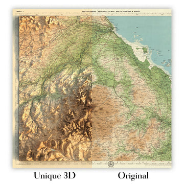
For something truly unique, this map is also available in "Unique 3D", our trademarked process that dramatically transforms the map so that it has a wonderful sense of depth. We combine the original map with detailed topography and elevation data, so that mountains and the terrain really "pop". For more info and examples of 3D maps, check my Unique 3D page.
Step into the storied landscapes of Canada’s Pacific frontier with “British Columbia.”, a map crafted in 1922 by the illustrious John George Bartholomew. Bearing its original title with a period—an elegant touch from the era—this map stands as a testament to the golden age of cartography. Commissioned for the second issue of the 1920 edition of The Times Atlas & Gazetteer of the World, it captures the province at a pivotal moment in its development, when railways, resource towns, and natural wonders were shaping the region’s destiny. The map’s meticulous detail invites viewers to explore the vast and varied terrain of British Columbia, from the rugged Pacific coastline to the snow-capped peaks of the Rocky Mountains.
Bartholomew, often hailed as “the Prince of Cartographers,” brought an unprecedented level of artistry and precision to this work. His innovative use of hypsometric tints—subtle gradations of color to indicate elevation—breathes life into the mountainous spine of the province, while spot heights pinpoint the summits that define its skyline. The map’s bathymetric tints reveal the mysterious depths of the Pacific and the intricate waterways that carve through the land, such as the mighty Fraser and Columbia Rivers. This visual language not only enhances the map’s beauty but also provides an intuitive understanding of British Columbia’s dramatic topography.
A closer examination reveals a province teeming with geographic and historic significance. Vancouver Island and the Queen Charlotte Islands (now Haida Gwaii) are elegantly outlined, while the Cariboo and Kootenay regions—epicenters of gold rushes and mining booms—speak to the province’s adventurous past. The map highlights the labyrinthine network of lakes, including Okanagan and Shuswap, and the vital arteries of commerce and migration, such as the Canadian Pacific Railway. Each feature is rendered with a cartographer’s devotion to accuracy, reflecting Bartholomew’s commitment to both science and art.
Cities and towns are marked with a careful hand, offering a snapshot of British Columbia’s urban evolution. Vancouver, Victoria, and New Westminster anchor the province’s burgeoning metropolitan heart, while smaller settlements like Kamloops, Prince George, and Nelson hint at the waves of settlement and economic activity that defined the early twentieth century. The map’s inset of the Vancouver area, presented at an impressive scale, provides a rare and detailed glimpse into a city on the cusp of modern transformation.
This map is more than a geographical reference—it is a historical artifact, encapsulating the spirit of exploration, enterprise, and natural grandeur that has always defined British Columbia. As part of The Times Atlas’s legacy, it marks a significant transition in the history of mapmaking, with Bartholomew’s vision setting new standards for accuracy and aesthetic appeal. For collectors, historians, or those simply enchanted by the landscapes of the Pacific Northwest, “British Columbia.” offers a window into a world where every mountain, river, and border tells a story.
Cities and towns on this map
- Vancouver
- Surrey
- Burnaby
- Richmond
- Abbotsford
- Coquitlam
- Kelowna
- Nanaimo
- Kamloops
- Victoria
- Chilliwack
- Prince George
- Vernon
- Langley
- Penticton
- Campbell River
- Courtenay
- Powell River
- Nelson
- Cranbrook
- Dawson Creek
- Terrace
- Quesnel
- Williams Lake
- Fort St. John
- Trail
- Kitimat
- Smithers
- Revelstoke
- Fernie
- Golden
- Creston
- Merritt
- Salmon Arm
- Squamish
- Port Alberni
- Parksville
- Sidney
- Kimberley
- Grand Forks
- Castlegar
- Hope
- Lillooet
- Princeton
- Hazelton
- Stewart
- New Westminster
- Esquimalt
- Saanich
- North Vancouver
- West Vancouver
Notable Features & Landmarks
- The Rocky Mountains, prominently depicted with hypsometric tints
- The Coast Mountains, running parallel to the Pacific coastline
- The Columbia River, a major river system in southern British Columbia
- The Fraser River, flowing from the interior to the Pacific Ocean
- Okanagan Lake, a significant inland water body
- Vancouver Island, shown off the southwest coast
- Queen Charlotte Islands (now known as Haida Gwaii), labeled off the northwest coast
- The Strait of Georgia, separating Vancouver Island from the mainland
- Bathymetric shading in the Pacific Ocean and major lakes
- The Cariboo region, historically significant for the Cariboo Gold Rush
- The Kootenay region, known for its mountainous terrain and mining history
- The Skeena River, a major river in northern British Columbia
- The Peace River, flowing in the northeast of the province
- Major railway lines, including the Canadian Pacific Railway
- Provincial boundaries and county/district divisions clearly marked
- Inset map of the Vancouver area for greater detail
- Spot heights marking significant mountain peaks
- The Alaska boundary, showing the border with the United States
- The southern border with the United States (Washington State)
- The presence of several large lakes, such as Shuswap Lake and Arrow Lakes
Historical and design context
- Created in 1922 by John George Bartholomew, a renowned British cartographer known for his innovative techniques and artistry
- Commissioned for the second issue of the 1920 edition of The Times Atlas & Gazetteer of the World
- Marked a significant transition in cartographic sources, replacing maps by Andree from the 1895 edition
- Detailed political and physical map showing county or provincial boundaries, topography, hydrography, and transportation routes
- Employs hypsometric tints (color shading by elevation) and spot heights to depict topographical variations
- Bathymetric tints used to illustrate the depths of water bodies
- Included a page of corrections from the earlier 1920 edition, reflecting a commitment to accuracy and refinement
- Exemplifies early 20th-century cartographic art, with careful attention to color, typography, and geographical accuracy
- Represents a period of transition and advancement in atlas cartography, and is a valuable artifact for collectors and historians
- The Times Atlas series, beginning with this edition, has continued to be a standard reference for global cartography
- Emphasizes both physical geography (mountains, rivers, lakes) and political divisions (counties, districts)
- Notable for its detailed depiction of natural features and transportation infrastructure as of the early 1920s
Please double check the images to make sure that a specific town or place is shown on this map. You can also get in touch and ask us to check the map for you.
This map looks great at every size, but I always recommend going for a larger size if you have space. That way you can easily make out all of the details.
This map looks amazing at sizes all the way up to 70in (180cm). If you are looking for a larger map, please get in touch.
The model in the listing images is holding the 16x20in (40x50cm) version of this map.
The fifth listing image shows an example of my map personalisation service.
If you’re looking for something slightly different, check out my collection of the best old maps to see if something else catches your eye.
Please contact me to check if a certain location, landmark or feature is shown on this map.
This would make a wonderful birthday, Christmas, Father's Day, work leaving, anniversary or housewarming gift for someone from the areas covered by this map.
This map is available as a giclée print on acid free archival matte paper, or you can buy it framed. The frame is a nice, simple black frame that suits most aesthetics. Please get in touch if you'd like a different frame colour or material. My frames are glazed with super-clear museum-grade acrylic (perspex/acrylite), which is significantly less reflective than glass, safer, and will always arrive in perfect condition.
This map is also available as a float framed canvas, sometimes known as a shadow gap framed canvas or canvas floater. The map is printed on artist's cotton canvas and then stretched over a handmade box frame. We then "float" the canvas inside a wooden frame, which is available in a range of colours (black, dark brown, oak, antique gold and white). This is a wonderful way to present a map without glazing in front. See some examples of float framed canvas maps and explore the differences between my different finishes.
For something truly unique, this map is also available in "Unique 3D", our trademarked process that dramatically transforms the map so that it has a wonderful sense of depth. We combine the original map with detailed topography and elevation data, so that mountains and the terrain really "pop". For more info and examples of 3D maps, check my Unique 3D page.
Many of our maps and art prints are chosen as thoughtful gifts for homes, offices, studies and meaningful places.
Choose a framed option for the easiest ready-to-hang gift, or choose an unframed print if the recipient may prefer to select their own frame.
We make orders locally in 23 countries around the world, so gifts can often be produced close to the recipient. This helps them arrive faster, travel more safely, and avoid customs or import duty surprises.
- We can deliver directly to the recipient
- Framed pieces arrive ready to hang
- Unframed prints are carefully packed in a strong protective tube
- Almost every order is made locally, for faster, safer gifting
- 90-day returns give the recipient time to decide
If you are not sure what to choose, please contact us. We can help you pick the right map, size, finish or delivery option.
Most orders are made locally and delivered in around 2–3 working days, depending on the product, size and destination.
We print and frame maps and artwork in 23 countries around the world, so your order is usually made close to you or your recipient. That means faster delivery, less time in transit, and no customs or import duty surprises.
Personalised and customised pieces usually take an extra 1–2 working days, because we prepare your design and send it to you for approval before printing.
Very large framed orders can take a little longer, as they need extra care in production and delivery.
Every order is carefully packaged: unframed prints are sent in a strong protective tube, while framed pieces are securely packed with protective materials around the frame.
If you need your order by a particular date, please contact us before ordering. We’ll check the best production route and delivery option for your location.
Express delivery is available at checkout for most countries. Next-day delivery is available in the UK, US, Singapore and the UAE.
Your order is covered by our 90-day returns policy and 10-year guarantee.
Our standard frame is a gallery-style black ash hardwood frame, with a simple, modern look. It is approximately 20mm (0.8in) wide. You can also view some lovely customer photos of framed maps and art.
We use super-clear acrylic glazing, also known as Perspex or Acrylite, instead of traditional glass. It is lighter, safer, and has lower reflectivity, giving the artwork a clearer, cleaner appearance.
Six standard frame colours are available at no extra cost: black, dark brown, dark grey, oak, white, and antique gold. Custom framing and mounting/matting is also available for customers looking for something more specific.
Most maps, art prints, and illustrations are also available as a framed canvas. We use matte cotton canvas, stretch it over a sustainably sourced wooden box frame, and then float the piece within a wooden outer frame. The finished result is beautifully presented, with no glazing between you and the artwork.
All frames are supplied ready to hang, with either string or brackets fitted to the back. Very large frames will include heavy-duty hanging plates and/or a mounting baton. If you have any questions, please get in touch.
We can also supply old maps and artwork on canvas, foam board, cotton rag, and other materials.
If you would prefer to frame your map or artwork yourself, please read our size guide before ordering.
Every Unique Maps piece begins with an authentic cartographic source or an original design from our London studio.
For our historic maps, we source rare originals from libraries, archives, auction houses and private collections around the world. We carefully restore each map for print—repairing age-related damage, balancing colour and improving clarity while preserving its original detail, texture and character.
Once restored, the map is prepared for your chosen size and finish. Your piece is then printed and, where selected, framed close to its delivery destination.
Our map prints use acid-free 200gsm archival matte paper and fade-resistant pigment inks, creating a rich, non-glossy finish designed to last. Framed maps use crystal-clear optical acrylic and arrive ready to hang.
Canvas, cotton-rag and other specialist presentations are also available. Learn more about our materials and finishes.
Personalising your map
You can add a short title or dedication, mark one meaningful place, or request one considered visual detail. For personalised designs, we send a proof before printing and you can request changes before approval.
For more complex bespoke commissions, contact our design team.
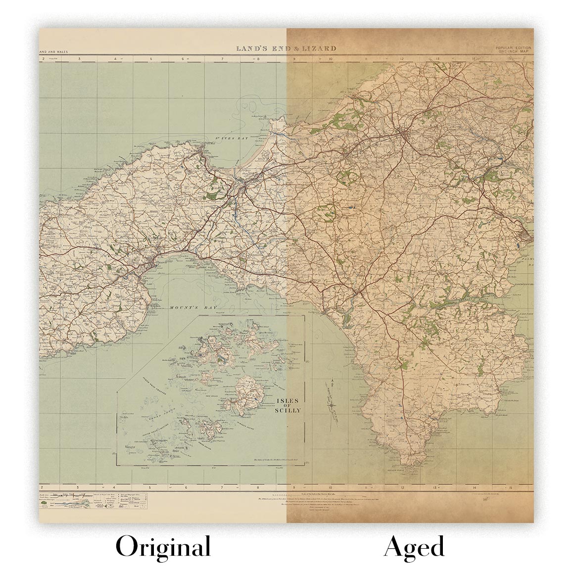
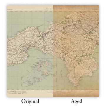
Original or Aged
Choose Original for true-to-source colour, or Aged for a warmer, richer antique character created with our specialist ageing process. See examples of our Aged maps.
If you are not happy with your order for any reason, contact me and I'll get it fixed ASAP, free of charge. Please see my returns and refund policy for more information.
I am very confident you will like your restored map or art print. I have been doing this since 1984. I'm a 5-star Etsy seller. I have sold tens of thousands of maps and art prints and have over 5,000 real 5-star reviews. My work has been featured in interior design magazines, on the BBC, and on the walls of dozens of 5-star hotels.
I use a unique process to restore maps and artwork that is massively time consuming and labour intensive. Hunting down the original maps and illustrations can take months. I use state of the art and eye-wateringly expensive technology to scan and restore them. As a result, I guarantee my maps and art prints are a cut above the rest. I stand by my products and will always make sure you're 100% happy with what you receive.
Almost all of my maps and art prints look amazing at large sizes (200cm, 6.5ft+) and I can frame and deliver them to you as well, via special oversized courier. Contact me to discuss your specific needs.
Or try searching for something!


