

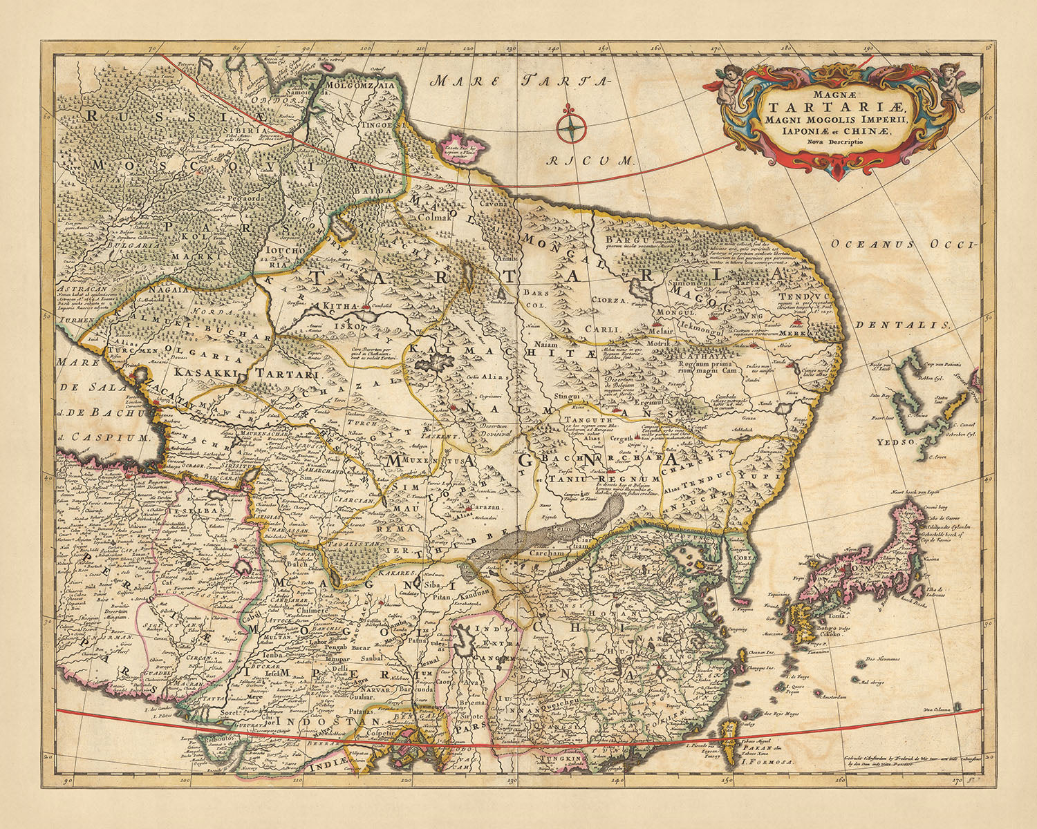


Rare Old Map of Greater Tartary, the Great Mogul's Empire, Japan, and China by Visscher, 1690: East Asia, Central Asia, Beijing, Tokyo, Himalayas
20% off 2 — 33% off 3
Add any two eligible items to your bag to receive 20% off. Add a third and it will be complimentary (equivalent to 33% off when purchasing three).
No code needed — the offer applies automatically at checkout.
Valid on all standard maps and fine art prints. You can mix and match any designs.
If you’d like to ship items to multiple addresses, please contact us before placing your order.
Custom and bespoke commissions are excluded.
Contact us if you have any questions
 Designed in London Made in the USA
Designed in London • Made in the USA
Designed in London Made in the USA
Designed in London • Made in the USA

Choose your size
Choose your finish


(More info)
Gift message & custom finish

If you want to add a gift message, or a finish (jigsaw, aluminium board, etc.) that is not available here, please request it in the "order note" when you check out.
Every order is custom made, so if you need the size adjusted slightly, or printed on an unusual material, just let us know. We've done thousands of custom orders over the years, so there's (almost) nothing we can't manage.
You can also contact us before you order, if you prefer!

- Made locally for fast, safe delivery
- No import duty or hidden fees
- Need advice? Message us on WhatsApp
Own a piece of history
7,000+ 5 star reviews


Immerse yourself in the rich tapestry of history with the 'Magnae Tartariae, Magni Mogolis Imperii, Japoniae et Chinae nova descriptio', an exquisite map crafted by Nicolaes Visscher II in 1690. Translated into English, the title of this map is 'New Description of Greater Tartary, the Great Mogul's Empire, Japan, and China'. The map offers a fascinating glimpse into the political and geographical landscape of these regions during the late 17th century, a time when the Dutch were making significant inroads into global trade and exploration.
The map is a testament to the meticulous craftsmanship and artistic prowess of Nicolaes Visscher II, who hailed from a lineage of celebrated Dutch mapmakers. It covers Northeast Asia, highlighting political and administrative boundaries, cities, towns, waterways, canals, landmarks, lakes, and mountains. The intricate details of the map bring to life the vibrant cities of Beijing and Tokyo, as well as the majestic Himalayas.
The 'Magnae Tartariae, Magni Mogolis Imperii, Japoniae et Chinae nova descriptio' is not just a map, but a historical artifact that offers a window into the past. Hand-colored in outline, the engraved map includes a decorative cartouche and compass rose, adding to its aesthetic appeal. The relief shown pictorially provides a three-dimensional effect, further enhancing the map's visual impact.
This map is a valuable addition to any collection, be it for a history enthusiast, a lover of cartography, or a discerning collector of fine art. Its historical significance and artistic beauty make it a remarkable piece that stands out for its uniqueness. The 'Magnae Tartariae, Magni Mogolis Imperii, Japoniae et Chinae nova descriptio' is not just a map, but a conversation starter, a source of inspiration, and a treasure trove of historical insights.
Some of the significant locations shown on this map:
Greater Tartary:
- Samarkand: Known as Maracanda in the 4th century BCE, it was the capital of the Sogdian satrapy under the Achaemenid Empire.
- Tashkent: Founded by 5th century BCE, it's an ancient city located on the Great Silk Road between China and the Mediterranean.
- Omsk: Founded in 1716, it's known for its rich history and architectural monuments.
- Novosibirsk: Founded in 1893, it's the third-largest city in Russia.
- Kazan: Founded in the medieval period, it's known for the Kazan Kremlin, a World Heritage Site.
- Ulaanbaatar: Founded in 1639, it's the capital of Mongolia.
The Great Mogul's Empire:
- Delhi: Founded as early as 6th century BCE, it was the capital of several empires in ancient India.
- Agra: Founded in 1504, it's known for the Taj Mahal, a UNESCO World Heritage Site.
- Lahore: Known as Lavapuri in ancient times, it's one of the oldest cities in South Asia.
- Multan: Known as the City of Sufis or City of Saints, it was an important center of Islamic philosophy.
- Ahmedabad: Founded in 1411, it's known for its rich cultural past and architectural marvels.
Japan:
- Tokyo: Known as Edo until 1868, it's the capital of Japan.
- Kyoto: Founded in 794, it was the capital of Japan for over a thousand years.
- Osaka: Known as Naniwa during the early classical period, it's one of Japan's oldest cities.
- Nagoya: Founded during the Kamakura period, it's known for Nagoya Castle.
- Hiroshima: Established in 1589, it's known for its historical significance during World War II.
China:
- Beijing: Known as Peking, it's the capital of China.
- Shanghai: Known as Hu for short, it's the global financial hub of China.
- Guangzhou: Known as Canton, it's known for its avant-garde architecture.
- Hangzhou: Known as Lin'an in ancient times, it's known for the West Lake, a UNESCO World Heritage Site.
- Chengdu: Known as Brocade City, it's the home of the giant panda.
Notable Natural Phenomena:
- The Great Wall of China: One of the greatest wonders of the world, stretching over 21,196 km from east to west of China.
- Mount Everest: The highest mountain in the world, located in the Himalayas.
- Gobi Desert: The largest desert region in Asia, spanning two countries - China and Mongolia.
- Yangtze River: The longest river in Asia, flowing for 6,300 kilometers.
- Lake Baikal: The deepest and oldest freshwater lake in the world, located in Siberia.
Notable Historical Events (1600-1690):
- The Fall of the Ming Dynasty (1644): The Ming Dynasty was replaced by the Qing Dynasty after the siege of Beijing.
- Shimabara Rebellion (1637-1638): A revolt of Japanese Christians against the Tokugawa shogunate.
- The Great Fire of Meireki (1657): A citywide fire in Edo (now Tokyo) that destroyed over half the city and claimed over 100,000 lives.
Please double check the images to make sure that a specific town or place is shown on this map. You can also get in touch and ask us to check the map for you.
This map looks great at all sizes: 12x16in (30.5x41cm), 16x20in (40.5x51cm), 18x24in (45.5x61cm), 24x30in (61x76cm), 32x40in (81.5x102cm), 40x50in (102x127cm), 48x60in (122x153cm) and 56x70in (142x178cm), but it looks even better when printed large.
I can create beautiful, large prints of this map up to 90in (229cm). Please get in touch if you're looking for larger, customised or different framing options.
The model in the listing images is holding the 16x20in (40.5x51cm) version of this map.
The fifth listing image shows an example of my map personalisation service.
If you’re looking for something slightly different, check out my collection of the best old maps of Europe and European cities to see if something else catches your eye.
Please contact me to check if a certain location, landmark or feature is shown on this map.
This would make a wonderful birthday, Christmas, Father's Day, work leaving, anniversary or housewarming gift for someone from the areas covered by this map.
This map is available as a giclée print on acid free archival matte paper, or you can buy it framed. The frame is a nice, simple black frame that suits most aesthetics. Please get in touch if you'd like a different frame colour or material. My frames are glazed with super-clear museum-grade acrylic (perspex/acrylite), which is significantly less reflective than glass, safer, and will always arrive in perfect condition.
This map is also available as a float framed canvas, sometimes known as a shadow gap framed canvas or canvas floater. The map is printed on artist's cotton canvas and then stretched over a handmade box frame. We then "float" the canvas inside a wooden frame, which is available in a range of colours (black, dark brown, oak, antique gold and white). This is a wonderful way to present a map without glazing in front. See some examples of float framed canvas maps and explore the differences between my different finishes.
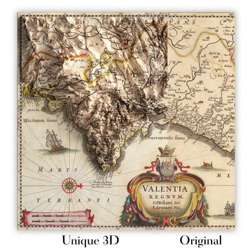
For something truly unique, this map is also available in "Unique 3D", our trademarked process that dramatically transforms the map so that it has a wonderful sense of depth. We combine the original map with detailed topography and elevation data, so that mountains and the terrain really "pop". For more info and examples of 3D maps, check my Unique 3D page.
Many of our maps and art prints are chosen as thoughtful gifts for homes, offices, studies and meaningful places.
Choose a framed option for the easiest ready-to-hang gift, or choose an unframed print if the recipient may prefer to select their own frame.
We make orders locally in 23 countries around the world, so gifts can often be produced close to the recipient. This helps them arrive faster, travel more safely, and avoid customs or import duty surprises.
- We can deliver directly to the recipient
- Framed pieces arrive ready to hang
- Unframed prints are carefully packed in a strong protective tube
- Almost every order is made locally, for faster, safer gifting
- 90-day returns give the recipient time to decide
If you are not sure what to choose, please contact us. We can help you pick the right map, size, finish or delivery option.
Most orders are made locally and delivered in around 2–3 working days, depending on the product, size and destination.
We print and frame maps and artwork in 23 countries around the world, so your order is usually made close to you or your recipient. That means faster delivery, less time in transit, and no customs or import duty surprises.
Personalised and customised pieces usually take an extra 1–2 working days, because we prepare your design and send it to you for approval before printing.
Very large framed orders can take a little longer, as they need extra care in production and delivery.
Every order is carefully packaged: unframed prints are sent in a strong protective tube, while framed pieces are securely packed with protective materials around the frame.
If you need your order by a particular date, please contact us before ordering. We’ll check the best production route and delivery option for your location.
Express delivery is available at checkout for most countries. Next-day delivery is available in the UK, US, Singapore and the UAE.
Your order is covered by our 90-day returns policy and 10-year guarantee.
Our standard frame is a gallery-style black ash hardwood frame, with a simple, modern look. It is approximately 20mm (0.8in) wide. You can also view some lovely customer photos of framed maps and art.
We use super-clear acrylic glazing, also known as Perspex or Acrylite, instead of traditional glass. It is lighter, safer, and has lower reflectivity, giving the artwork a clearer, cleaner appearance.
Six standard frame colours are available at no extra cost: black, dark brown, dark grey, oak, white, and antique gold. Custom framing and mounting/matting is also available for customers looking for something more specific.
Most maps, art prints, and illustrations are also available as a framed canvas. We use matte cotton canvas, stretch it over a sustainably sourced wooden box frame, and then float the piece within a wooden outer frame. The finished result is beautifully presented, with no glazing between you and the artwork.
All frames are supplied ready to hang, with either string or brackets fitted to the back. Very large frames will include heavy-duty hanging plates and/or a mounting baton. If you have any questions, please get in touch.
We can also supply old maps and artwork on canvas, foam board, cotton rag, and other materials.
If you would prefer to frame your map or artwork yourself, please read our size guide before ordering.
My maps are extremely high quality reproductions of original maps.
I source original, rare maps from libraries, auction houses and private collections around the world, restore them at my London workshop, and then use specialist giclée inks and printers to create beautiful maps that look even better than the original.
My maps are printed on acid-free archival matte (not glossy) paper that feels very high quality and almost like card. In technical terms the paper weight/thickness is 10mil/200gsm. It's perfect for framing.
I print with Epson ultrachrome giclée UV fade resistant pigment inks - some of the best inks you can find.
I can also make maps on canvas, cotton rag and other exotic materials.
Learn more about The Unique Maps Co.
Map personalisation
If you're looking for the perfect anniversary or housewarming gift, I can personalise your map to make it truly unique. For example, I can add a short message, or highlight an important location, or add your family's coat of arms.
The options are almost infinite. Please see my map personalisation page for some wonderful examples of what's possible.
To order a personalised map, select "personalise your map" before adding it to your basket.
Get in touch if you're looking for more complex customisations and personalisations.
Map ageing
I have been asked hundreds of times over the years by customers if they could buy a map that looks even older.
Well, now you can, by selecting Aged before you add a map to your basket.
All the product photos you see on this page show the map in its Original form. This is what the map looks like today.
If you select Aged, I will age your map by hand, using a special and unique process developed through years of studying old maps, talking to researchers to understand the chemistry of aging paper, and of course... lots of practice!
If you're unsure, stick to the Original colour of the map. If you want something a bit darker and older looking, go for Aged.
If you are not happy with your order for any reason, contact me and I'll get it fixed ASAP, free of charge. Please see my returns and refund policy for more information.
I am very confident you will like your restored map or art print. I have been doing this since 1984. I'm a 5-star Etsy seller. I have sold tens of thousands of maps and art prints and have over 5,000 real 5-star reviews. My work has been featured in interior design magazines, on the BBC, and on the walls of dozens of 5-star hotels.
I use a unique process to restore maps and artwork that is massively time consuming and labour intensive. Hunting down the original maps and illustrations can take months. I use state of the art and eye-wateringly expensive technology to scan and restore them. As a result, I guarantee my maps and art prints are a cut above the rest. I stand by my products and will always make sure you're 100% happy with what you receive.
Almost all of my maps and art prints look amazing at large sizes (200cm, 6.5ft+) and I can frame and deliver them to you as well, via special oversized courier. Contact me to discuss your specific needs.
Or try searching for something!


