


Rare Old Birdseye Map of Puget Sound Region, 1927: Seattle, Tacoma, Olympic Peninsula, San Juan Islands, Mount Rainier
The Collector’s Offer
Choose two eligible works and receive 20% off both. Choose three and the lowest-priced one is complimentary, a maximum saving of 33%.
Mix and match eligible standard maps and fine-art prints. No code is required; the offer is applied automatically at checkout.
Standard made-to-order configurations are included. Bespoke sizes, personalised designs and commissioned work are excluded.
Need delivery to different addresses? Contact us before ordering.The Collector’s Offer
Choose two eligible works and receive 20% off both. Choose three and the lowest-priced one is complimentary, a maximum saving of 33%.
Mix and match eligible standard maps and fine-art prints. No code is required; the offer is applied automatically at checkout.
Standard made-to-order configurations are included. Bespoke sizes, personalised designs and commissioned work are excluded.
Need delivery to different addresses? Contact us before ordering. Designed in London Made in the USA
Designed in London • Made in the USA
Designed in London Made in the USA
Designed in London • Made in the USA

Restored from the original 1927 map and printed to museum-grade archival standards. Read the story behind this map
Choose your size
Choose your finish


(More info)
Gift message & custom finish

If you want to add a gift message, or a finish (jigsaw, aluminium board, etc.) that is not available here, please request it in the "order note" when you check out.
Every order is custom made, so if you need the size adjusted slightly, or printed on an unusual material, just let us know. We've done thousands of custom orders over the years, so there's (almost) nothing we can't manage.
You can also contact us before you order, if you prefer!

- Made locally for fast, safe delivery
- No import duty or hidden fees
- Need advice? Call us or message on WhatsApp
Own a piece of history
8,000+ five-star reviews


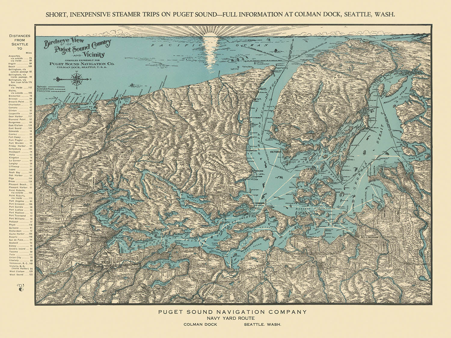
Step into the vibrant maritime world of the Pacific Northwest with the “Birdseye View of Puget Sound Country and Vicinity,” an evocative...
Continue readingStep into the vibrant maritime world of the Pacific Northwest with the “Birdseye View of Puget Sound Country and Vicinity,” an evocative 1927 cartographic masterpiece commissioned by the Puget Sound Navigation Company. This captivating map, crafted at the height of the region’s steamboat era, invites viewers to explore a landscape defined by its intricate waterways, majestic mountains, and lush islands. The original title itself hints at the map’s panoramic ambition, offering a sweeping perspective that encompasses the Puget Sound, Olympic Peninsula, San Juan Islands, Vancouver Island, and the surrounding region—an area where nature and navigation intertwine in spectacular fashion.
The Puget Sound Navigation Company, affectionately known as the Black Ball Line, was founded by Charles E. Peabody in 1898 and soon became synonymous with maritime innovation and regional connectivity. By the 1930s, PSNC commanded a near-monopoly on cross-sound travel, ferrying passengers and goods between bustling ports and tranquil outposts. This map was conceived as both a promotional tool and a celebration of the company’s extensive routes, showcasing the accessibility of “Short Enjoyable Outings” to destinations such as Hood Canal, the Olympic Peninsula, and the San Juan Islands—each an alluring escape for urban dwellers and adventurers alike.
The map’s bird’s-eye perspective is a testament to the artistry and technical prowess of early 20th-century cartographers. Rendered with meticulous detail, it presents a richly textured tableau where waterways gleam, mountains soar, and forests sprawl across the land. The Olympic and Cascade mountain ranges rise dramatically in the background, with iconic peaks like Mount Rainier and Mount Baker anchoring the horizon. The map’s pictorial style not only serves as a navigational aid but also as an invitation to marvel at the natural grandeur and geographic complexity of the Pacific Northwest.
Beyond its visual splendor, the map is a document of historical significance, capturing a pivotal moment when ferries and steamships were the lifeblood of regional commerce and culture. The international boundary between the United States and Canada is subtly traced, connecting the thriving cities of Seattle, Tacoma, Vancouver, and Victoria, while also delineating the wild beauty of the Olympic Peninsula and the intricate archipelago of the San Juan Islands. Major rivers, bays, and inlets—such as the Strait of Juan de Fuca and Georgia Strait—are elegantly depicted, underscoring the region’s reliance on waterborne transportation.
Every detail of this map reflects the spirit of exploration and enterprise that defined the era. Lighthouses and navigational aids punctuate the coastline, guiding vessels through fog and tide. Forested landscapes and rugged capes evoke the untamed character of the land, while the absence of modern bridges and highways hints at a time when the rhythm of life was set by the schedule of the next departing steamer. This “Birdseye View of Puget Sound Country and Vicinity” is more than a map—it is a window into a bygone age of adventure, innovation, and natural wonder.
Cities and towns on this map
- Seattle
- Tacoma
- Olympia
- Everett
- Bellingham
- Port Angeles
- Bremerton
- Anacortes
- Port Townsend
- Vancouver (BC)
- Victoria (BC)
Notable Features & Landmarks
- Puget Sound (major waterway)
- Olympic Peninsula (prominent landmass)
- San Juan Islands (island group)
- Vancouver Island (large island, British Columbia)
- Hood Canal (fjord-like arm of Puget Sound)
- Strait of Juan de Fuca (major strait between Washington and Vancouver Island)
- Georgia Strait (waterway between Vancouver Island and mainland BC)
- Mount Rainier (depicted as a prominent mountain)
- Mount Baker (depicted as a prominent mountain)
- Olympic Mountains (mountain range on the peninsula)
- Cascade Mountains (mountain range to the east)
- Ferry and steamboat routes (illustrated on the map)
- International boundary between the United States and Canada (visible on the map)
- Major rivers (e.g., Snohomish River, Skagit River, depicted)
- Lighthouses and navigational aids (illustrated along waterways)
- Bays and inlets (e.g., Elliott Bay, Bellingham Bay)
- Prominent capes and peninsulas (e.g., Cape Flattery)
Historical and design context
- Created in 1927 by the Puget Sound Navigation Company (PSNC), also known as the Black Ball Line.
- PSNC was founded by Charles E. Peabody in 1898 and became a dominant force in regional maritime travel.
- The map was designed as a promotional tool to highlight ferry and steamboat routes and encourage tourism.
- Bird’s-eye perspective, highly detailed and pictorial, emphasizing natural features and waterways.
- Reflects the critical role of ferries and steamships in the Pacific Northwest before the era of modern highways and bridges.
- Highlights the accessibility of “Short Enjoyable Outings” to scenic regional destinations.
- Captures a pivotal era of transportation and exploration in the Pacific Northwest.
Please double check the images to make sure that a specific town or place is shown on this map. You can also get in touch and ask us to check the map for you.
This map looks great at every size, but I always recommend going for a larger size if you have space. That way you can easily make out all of the details.
This map looks amazing at sizes all the way up to 90in (230cm). If you are looking for a larger map, please get in touch.
The model in the listing images is holding the 18x24in (45x60cm) version of this map.
The fifth listing image shows an example of my map personalisation service.
If you’re looking for something slightly different, check out my collection of the best old maps to see if something else catches your eye.
Please contact me to check if a certain location, landmark or feature is shown on this map.
This would make a wonderful birthday, Christmas, Father's Day, work leaving, anniversary or housewarming gift for someone from the areas covered by this map.
This map is available as a giclée print on acid free archival matte paper, or you can buy it framed. The frame is a nice, simple black frame that suits most aesthetics. Please get in touch if you'd like a different frame colour or material. My frames are glazed with super-clear museum-grade acrylic (perspex/acrylite), which is significantly less reflective than glass, safer, and will always arrive in perfect condition.
This map is also available as a float framed canvas, sometimes known as a shadow gap framed canvas or canvas floater. The map is printed on artist's cotton canvas and then stretched over a handmade box frame. We then "float" the canvas inside a wooden frame, which is available in a range of colours (black, dark brown, oak, antique gold and white). This is a wonderful way to present a map without glazing in front. See some examples of float framed canvas maps and explore the differences between my different finishes.
For something truly unique, this map is also available in "Unique 3D", our trademarked process that dramatically transforms the map so that it has a wonderful sense of depth. We combine the original map with detailed topography and elevation data, so that mountains and the terrain really "pop". For more info and examples of 3D maps, check my Unique 3D page.
Step into the vibrant maritime world of the Pacific Northwest with the “Birdseye View of Puget Sound Country and Vicinity,” an evocative 1927 cartographic masterpiece commissioned by the Puget Sound Navigation Company. This captivating map, crafted at the height of the region’s steamboat era, invites viewers to explore a landscape defined by its intricate waterways, majestic mountains, and lush islands. The original title itself hints at the map’s panoramic ambition, offering a sweeping perspective that encompasses the Puget Sound, Olympic Peninsula, San Juan Islands, Vancouver Island, and the surrounding region—an area where nature and navigation intertwine in spectacular fashion.
The Puget Sound Navigation Company, affectionately known as the Black Ball Line, was founded by Charles E. Peabody in 1898 and soon became synonymous with maritime innovation and regional connectivity. By the 1930s, PSNC commanded a near-monopoly on cross-sound travel, ferrying passengers and goods between bustling ports and tranquil outposts. This map was conceived as both a promotional tool and a celebration of the company’s extensive routes, showcasing the accessibility of “Short Enjoyable Outings” to destinations such as Hood Canal, the Olympic Peninsula, and the San Juan Islands—each an alluring escape for urban dwellers and adventurers alike.
The map’s bird’s-eye perspective is a testament to the artistry and technical prowess of early 20th-century cartographers. Rendered with meticulous detail, it presents a richly textured tableau where waterways gleam, mountains soar, and forests sprawl across the land. The Olympic and Cascade mountain ranges rise dramatically in the background, with iconic peaks like Mount Rainier and Mount Baker anchoring the horizon. The map’s pictorial style not only serves as a navigational aid but also as an invitation to marvel at the natural grandeur and geographic complexity of the Pacific Northwest.
Beyond its visual splendor, the map is a document of historical significance, capturing a pivotal moment when ferries and steamships were the lifeblood of regional commerce and culture. The international boundary between the United States and Canada is subtly traced, connecting the thriving cities of Seattle, Tacoma, Vancouver, and Victoria, while also delineating the wild beauty of the Olympic Peninsula and the intricate archipelago of the San Juan Islands. Major rivers, bays, and inlets—such as the Strait of Juan de Fuca and Georgia Strait—are elegantly depicted, underscoring the region’s reliance on waterborne transportation.
Every detail of this map reflects the spirit of exploration and enterprise that defined the era. Lighthouses and navigational aids punctuate the coastline, guiding vessels through fog and tide. Forested landscapes and rugged capes evoke the untamed character of the land, while the absence of modern bridges and highways hints at a time when the rhythm of life was set by the schedule of the next departing steamer. This “Birdseye View of Puget Sound Country and Vicinity” is more than a map—it is a window into a bygone age of adventure, innovation, and natural wonder.
Cities and towns on this map
- Seattle
- Tacoma
- Olympia
- Everett
- Bellingham
- Port Angeles
- Bremerton
- Anacortes
- Port Townsend
- Vancouver (BC)
- Victoria (BC)
Notable Features & Landmarks
- Puget Sound (major waterway)
- Olympic Peninsula (prominent landmass)
- San Juan Islands (island group)
- Vancouver Island (large island, British Columbia)
- Hood Canal (fjord-like arm of Puget Sound)
- Strait of Juan de Fuca (major strait between Washington and Vancouver Island)
- Georgia Strait (waterway between Vancouver Island and mainland BC)
- Mount Rainier (depicted as a prominent mountain)
- Mount Baker (depicted as a prominent mountain)
- Olympic Mountains (mountain range on the peninsula)
- Cascade Mountains (mountain range to the east)
- Ferry and steamboat routes (illustrated on the map)
- International boundary between the United States and Canada (visible on the map)
- Major rivers (e.g., Snohomish River, Skagit River, depicted)
- Lighthouses and navigational aids (illustrated along waterways)
- Bays and inlets (e.g., Elliott Bay, Bellingham Bay)
- Prominent capes and peninsulas (e.g., Cape Flattery)
Historical and design context
- Created in 1927 by the Puget Sound Navigation Company (PSNC), also known as the Black Ball Line.
- PSNC was founded by Charles E. Peabody in 1898 and became a dominant force in regional maritime travel.
- The map was designed as a promotional tool to highlight ferry and steamboat routes and encourage tourism.
- Bird’s-eye perspective, highly detailed and pictorial, emphasizing natural features and waterways.
- Reflects the critical role of ferries and steamships in the Pacific Northwest before the era of modern highways and bridges.
- Highlights the accessibility of “Short Enjoyable Outings” to scenic regional destinations.
- Captures a pivotal era of transportation and exploration in the Pacific Northwest.
Please double check the images to make sure that a specific town or place is shown on this map. You can also get in touch and ask us to check the map for you.
This map looks great at every size, but I always recommend going for a larger size if you have space. That way you can easily make out all of the details.
This map looks amazing at sizes all the way up to 90in (230cm). If you are looking for a larger map, please get in touch.
The model in the listing images is holding the 18x24in (45x60cm) version of this map.
The fifth listing image shows an example of my map personalisation service.
If you’re looking for something slightly different, check out my collection of the best old maps to see if something else catches your eye.
Please contact me to check if a certain location, landmark or feature is shown on this map.
This would make a wonderful birthday, Christmas, Father's Day, work leaving, anniversary or housewarming gift for someone from the areas covered by this map.
This map is available as a giclée print on acid free archival matte paper, or you can buy it framed. The frame is a nice, simple black frame that suits most aesthetics. Please get in touch if you'd like a different frame colour or material. My frames are glazed with super-clear museum-grade acrylic (perspex/acrylite), which is significantly less reflective than glass, safer, and will always arrive in perfect condition.
This map is also available as a float framed canvas, sometimes known as a shadow gap framed canvas or canvas floater. The map is printed on artist's cotton canvas and then stretched over a handmade box frame. We then "float" the canvas inside a wooden frame, which is available in a range of colours (black, dark brown, oak, antique gold and white). This is a wonderful way to present a map without glazing in front. See some examples of float framed canvas maps and explore the differences between my different finishes.
For something truly unique, this map is also available in "Unique 3D", our trademarked process that dramatically transforms the map so that it has a wonderful sense of depth. We combine the original map with detailed topography and elevation data, so that mountains and the terrain really "pop". For more info and examples of 3D maps, check my Unique 3D page.
Many of our maps and art prints are chosen as thoughtful gifts for homes, offices, studies and meaningful places.
Choose a framed option for the easiest ready-to-hang gift, or choose an unframed print if the recipient may prefer to select their own frame.
We make orders locally in 23 countries around the world, so gifts can often be produced close to the recipient. This helps them arrive faster, travel more safely, and avoid customs or import duty surprises.
- We can deliver directly to the recipient
- Framed pieces arrive ready to hang
- Unframed prints are carefully packed in a strong protective tube
- Almost every order is made locally, for faster, safer gifting
- 90-day returns give the recipient time to decide
If you are not sure what to choose, please contact us. We can help you pick the right map, size, finish or delivery option.
Most orders are made locally and delivered in around 2–3 working days, depending on the product, size and destination.
We print and frame maps and artwork in 23 countries around the world, so your order is usually made close to you or your recipient. That means faster delivery, less time in transit, and no customs or import duty surprises.
Personalised and customised pieces usually take an extra 1–2 working days, because we prepare your design and send it to you for approval before printing.
Very large framed orders can take a little longer, as they need extra care in production and delivery.
Every order is carefully packaged: unframed prints are sent in a strong protective tube, while framed pieces are securely packed with protective materials around the frame.
If you need your order by a particular date, please contact us before ordering. We’ll check the best production route and delivery option for your location.
Express delivery is available at checkout for most countries. Next-day delivery is available in the UK, US, Singapore and the UAE.
Your order is covered by our 90-day returns policy and 10-year guarantee.
Our standard frame is a gallery-style black ash hardwood frame, with a simple, modern look. It is approximately 20mm (0.8in) wide. You can also view some lovely customer photos of framed maps and art.
We use super-clear acrylic glazing, also known as Perspex or Acrylite, instead of traditional glass. It is lighter, safer, and has lower reflectivity, giving the artwork a clearer, cleaner appearance.
Six standard frame colours are available at no extra cost: black, dark brown, dark grey, oak, white, and antique gold. Custom framing and mounting/matting is also available for customers looking for something more specific.
Most maps, art prints, and illustrations are also available as a framed canvas. We use matte cotton canvas, stretch it over a sustainably sourced wooden box frame, and then float the piece within a wooden outer frame. The finished result is beautifully presented, with no glazing between you and the artwork.
All frames are supplied ready to hang, with either string or brackets fitted to the back. Very large frames will include heavy-duty hanging plates and/or a mounting baton. If you have any questions, please get in touch.
We can also supply old maps and artwork on canvas, foam board, cotton rag, and other materials.
If you would prefer to frame your map or artwork yourself, please read our size guide before ordering.
My maps are extremely high quality reproductions of original maps.
I source original, rare maps from libraries, auction houses and private collections around the world, restore them at my London workshop, and then use specialist giclée inks and printers to create beautiful maps that look even better than the original.
My maps are printed on acid-free archival matte (not glossy) paper that feels very high quality and almost like card. In technical terms the paper weight/thickness is 10mil/200gsm. It's perfect for framing.
I print with Epson ultrachrome giclée UV fade resistant pigment inks - some of the best inks you can find.
I can also make maps on canvas, cotton rag and other exotic materials.
Learn more about The Unique Maps Co.
Map personalisation
If you're looking for the perfect anniversary or housewarming gift, I can personalise your map to make it truly unique. For example, I can add a short message, or highlight an important location, or add your family's coat of arms.
The options are almost infinite. Please see my map personalisation page for some wonderful examples of what's possible.
To order a personalised map, select "personalise your map" before adding it to your basket.
Get in touch if you're looking for more complex customisations and personalisations.
Map ageing
I have been asked hundreds of times over the years by customers if they could buy a map that looks even older.
Well, now you can, by selecting Aged before you add a map to your basket.
All the product photos you see on this page show the map in its Original form. This is what the map looks like today.
If you select Aged, I will age your map by hand, using a special and unique process developed through years of studying old maps, talking to researchers to understand the chemistry of aging paper, and of course... lots of practice!
If you're unsure, stick to the Original colour of the map. If you want something a bit darker and older looking, go for Aged.
If you are not happy with your order for any reason, contact me and I'll get it fixed ASAP, free of charge. Please see my returns and refund policy for more information.
I am very confident you will like your restored map or art print. I have been doing this since 1984. I'm a 5-star Etsy seller. I have sold tens of thousands of maps and art prints and have over 5,000 real 5-star reviews. My work has been featured in interior design magazines, on the BBC, and on the walls of dozens of 5-star hotels.
I use a unique process to restore maps and artwork that is massively time consuming and labour intensive. Hunting down the original maps and illustrations can take months. I use state of the art and eye-wateringly expensive technology to scan and restore them. As a result, I guarantee my maps and art prints are a cut above the rest. I stand by my products and will always make sure you're 100% happy with what you receive.
Almost all of my maps and art prints look amazing at large sizes (200cm, 6.5ft+) and I can frame and deliver them to you as well, via special oversized courier. Contact me to discuss your specific needs.
Or try searching for something!


