


Rare Old OS Map of Ceredigion & Montgomeryshire by Bartholomew, 1901: Aberystwyth, Cardigan Bay, Plynlimon, Southern Snowdonia, Cambrians
The price will update when you pick
different sizes and framing below


-
FREE delivery in 2 to 3 days
Free delivery in 2 to 3 days
Your map should be delivered in 2 to 3 working days with free delivery, worldwide.
We make maps by hand locally in 23 countries, including the USA
![]() . If you're buying a gift for someone in another country, we will make the map locally to them.
. If you're buying a gift for someone in another country, we will make the map locally to them.You will never pay import tax or customs duty.
Express delivery is available at checkout which can reduce the delivery time to 1-2 days.
Please note that personalised maps, and larger framed maps, can take longer to produce and deliver.
If you need your order to arrive by a certain date, contact me and we can discuss your options.
-
Certified sustainable +
we plant trees🌳
Sustainability & Tree Planting
Here at The Unique Maps Co., we have an unusually high affinity for paper. After all, without paper, there can be no maps!
That's why all of our paper, frames and packaging are from FSC certified sources.
But we don't stop there. We've partnered with Treeapp to plant trees around the world.
If you spend $60 or more, we'll plant a tree in your name.
We also cover the costs of offsetting the carbon emissions on all deliveries.
- Framing & free personalisation available
-
90 day money back guarantee
90 days to return and refund
Products can be returned within 90 days for a full refund, or exchange for another product.
For personalised or custom made items, we may offer you a non-expiring gift card, as we cannot resell personalised orders.
If you have any questions, get in touch. For more information, see our full returns & exchanges policy.
My maps are rare, museum-grade, restored old maps sourced from libraries, auction houses and private collections across the globe.
Contact me for larger sizes.
Custom size and finish

If you are looking for a size or finish that is not available here, please request it in the "order note" when you check out.
Every order is custom made, so if you need the size adjusted slightly, or printed on an unusual material, just let us know. We've done thousands of custom orders over the years, so there's (almost) nothing we can't manage.
You can also contact us before you order, if you prefer!
- FREE 2-3 day worldwide delivery
- 60 day money back guarantee
- Handmade, museum-grade quality
- Bank grade payment security

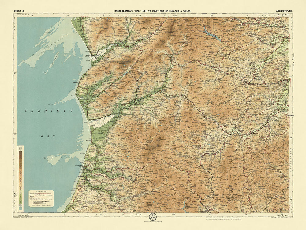
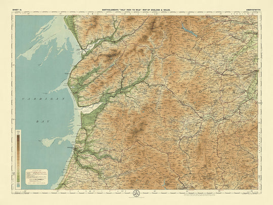
Sheet 16 - Aberystwyth, crafted by the esteemed cartographer J.G. Bartholomew in 1901, is a masterful depiction of the rich and varied landscapes of mid-Wales. This half-inch to the mile scale map, part of Bartholomew's flagship series, showcases the region's intricate topography with unparalleled clarity and detail. The map's innovative use of color layers to represent elevation and relief provides a vivid and engaging visual experience, making it a valuable resource for both historians and enthusiasts of early 20th-century cartography. The coastal expanse of Cardigan Bay, the rolling Cambrian Mountains, and the meandering rivers such as the Ystwyth and Rheidol are all meticulously illustrated, offering a comprehensive view of the area's natural beauty.
J.G. Bartholomew, a renowned Scottish cartographer, was known for his pioneering techniques in mapmaking, particularly his use of color to denote physical features. His work on this map reflects his dedication to precision and innovation, drawing from a reduced Ordnance Survey map of the same period. Bartholomew's maps were highly regarded for their clarity and aesthetic appeal, making them popular among cyclists and tourists of the time. The detailed representation of political boundaries and physical geography on this map not only serves as a navigational aid but also as a historical document, capturing the essence of the region during the early 1900s.
The map's design is both functional and artistic, with a landscape orientation that enhances its readability and visual impact. The subtle gradation of color bands to show land at different heights is a testament to Bartholomew's skill and attention to detail. This technique allows for a nuanced understanding of the terrain, highlighting features such as the Plynlimon, the highest point in the Cambrian Mountains, and the lush valleys carved by the region's rivers. The map also marks significant historical landmarks, including the ruins of Strata Florida Abbey and the iconic Devil's Bridge, adding layers of cultural and historical context to the geographical information.
Aberystwyth and its surrounding areas are rich in natural and historical significance, as depicted on this map. The coastal cliffs along Cardigan Bay, the expansive Hafod Estate Woodlands, and the serene Llyn Eiddwen are just a few of the notable features that stand out. The map also highlights important transportation routes, such as the Cambrian Railways and various cycling paths, reflecting the region's connectivity and accessibility during the early 20th century. National nature reserves like Ynyslas and Cors Caron (Tregaron Bog) are also prominently featured, underscoring the area's ecological importance and natural beauty.
This map not only serves as a navigational tool but also as a window into the past, offering insights into the historical and cultural landscape of mid-Wales. The towns and cities marked on the map, from the bustling Aberystwyth to the quaint villages of Lampeter and Tregaron, provide a snapshot of the human settlements that have shaped the region. The detailed depiction of political divisions, natural features, and historical landmarks makes this map a valuable piece for collectors and historians alike, capturing the essence of a bygone era with precision and artistry.
Cities and towns on this map:
- Ceredigion (Cardiganshire):
- Aberystwyth
- Lampeter
- Tregaron
- Aberaeron
- Llanilar
- Llanrhystud
- Llandysul
- Montgomeryshire:
- Machynlleth
- Llanidloes
Notable Features & Landmarks:
- Rivers and Water Bodies:
- River Ystwyth
- River Rheidol
- River Teifi
- Cardigan Bay
- Llyn Eiddwen (lake)
- Mountains and Hills:
- Plynlimon (highest point in the Cambrian Mountains)
- Cambrian Mountains
- Southern part of Snowdonia
- Forests and Woodlands:
- Hafod Estate Woodlands
- Historic Landmarks:
- Strata Florida Abbey (ruins of a Cistercian abbey)
- Devil's Bridge (famous bridge and waterfalls)
- Transportation:
- Cambrian Railways (railway lines)
- Various marked cycling routes
- Natural Features:
- Coastal cliffs along Cardigan Bay
- Various valleys including the Rheidol Valley
- Parks and Natural Reserves:
- Ynyslas National Nature Reserve
- Cors Caron National Nature Reserve (Tregaron Bog)
Historical and design context:
- Scale: Half-inch to the mile (1:126,720)
- Popularity: These maps were popular with cyclists and tourists, becoming Bartholomew's flagship series.
- Relief Representation: Distinctive use of different layers of color to represent landscape relief, with subtle gradation of color bands to show land at different heights.
- Base Map: Based on a reduced Ordnance Survey map from the same period.
- Date of Creation: 1901
- Mapmaker/Publisher: J.G. Bartholomew
- Context about the mapmaker: John George Bartholomew was a renowned Scottish cartographer and geographer, known for his innovative and detailed maps. He was instrumental in advancing the use of color in maps to represent different physical features.
- Themes Shown on the Map:
- Political Boundaries: Detailed depiction of political divisions and boundaries.
- Physical Features: Representation of physical geography including mountains, valleys, and rivers.
- Tourism and Cycling: Designed with tourists and cyclists in mind, providing clear and attractive navigation.
- Design and Style:
- Landscape Orientation: The map is laid out in a landscape format.
- Color Usage: Innovative use of color layers to denote elevation and relief.
- Detail Level: High level of detail suitable for navigation and exploration.
- Historical Significance:
- Technological Innovation: Reflects early 20th-century advancements in cartography and map printing.
- Cultural Impact: Played a significant role in promoting tourism and cycling in the British Isles.
Please double check the images to make sure that a specific town or place is shown on this map. You can also get in touch and ask us to check the map for you.
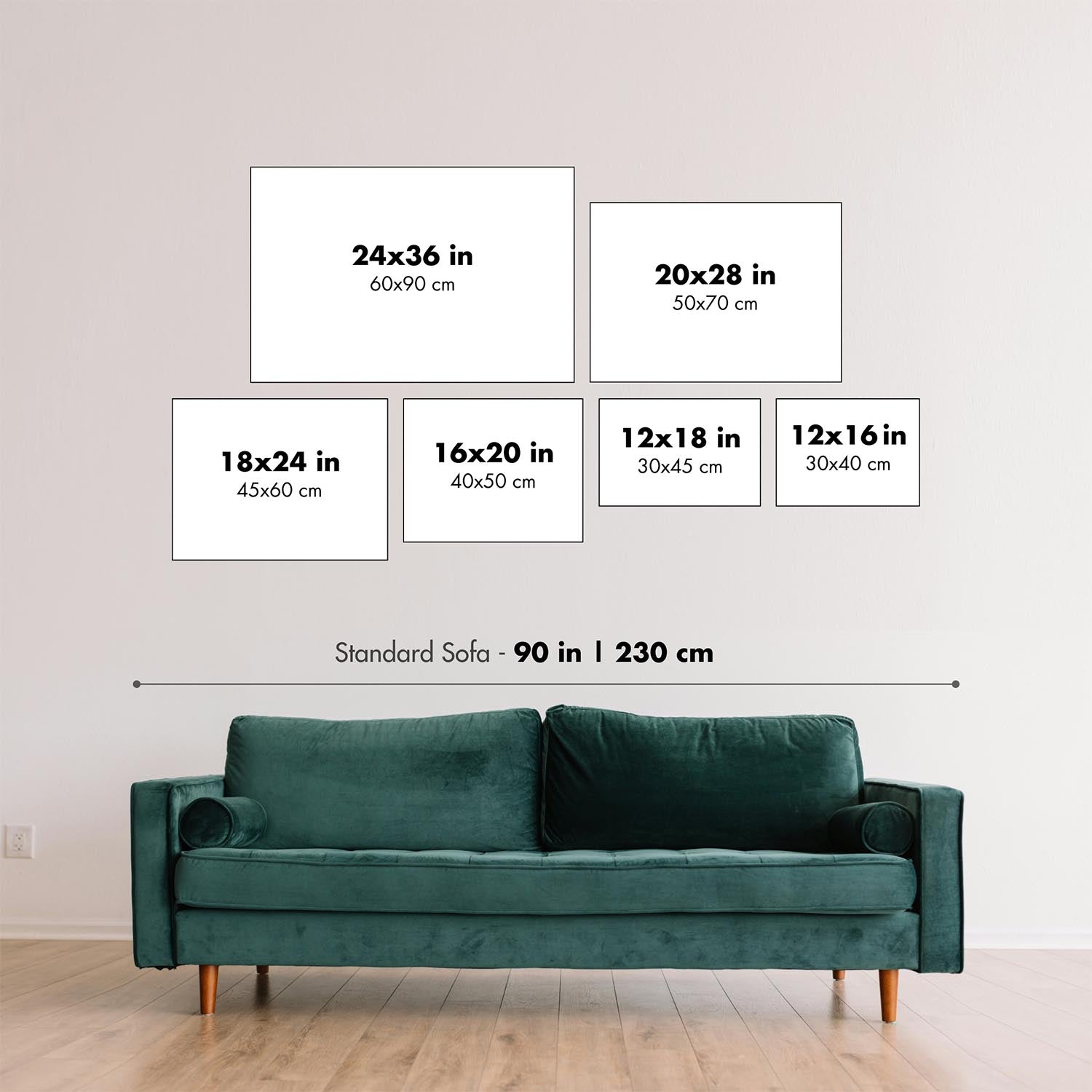
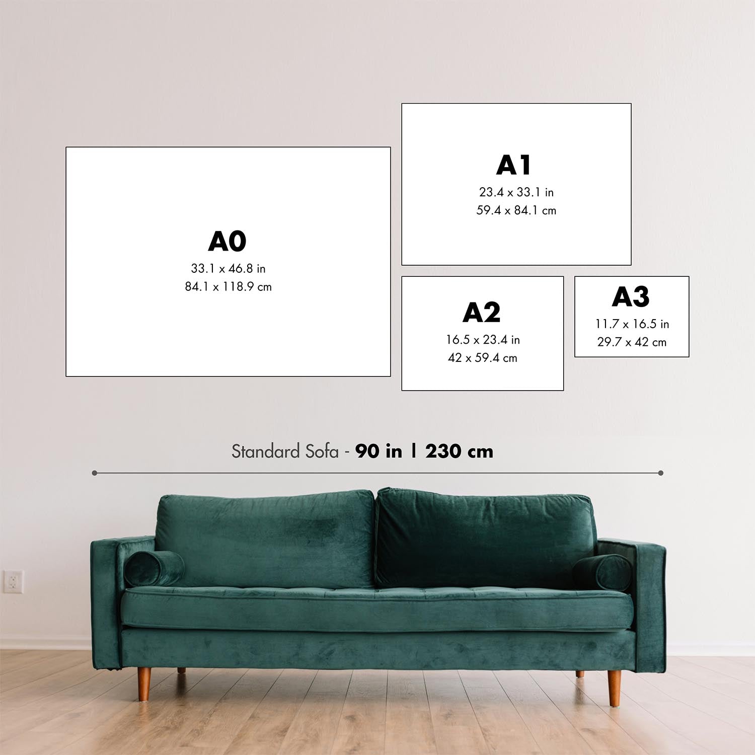
This map looks great at every size, but I always recommend going for a larger size if you have space. That way you can easily make out all of the details.
This map looks amazing at sizes all the way up to 70in (180cm). If you are looking for a larger map, please get in touch.
Please note: the labels on this map are hard to read if you order a map that is 20in (50cm) or smaller. The map is still very attractive, but if you would like to read the map easily, please buy a larger size.
The model in the listing images is holding the 18x24in (45x60cm) version of this map.
The fifth listing image shows an example of my map personalisation service.
If you’re looking for something slightly different, check out my collection of the best old maps to see if something else catches your eye.
Please contact me to check if a certain location, landmark or feature is shown on this map.
This would make a wonderful birthday, Christmas, Father's Day, work leaving, anniversary or housewarming gift for someone from the areas covered by this map.
This map is available as a giclée print on acid free archival matte paper, or you can buy it framed. The frame is a nice, simple black frame that suits most aesthetics. Please get in touch if you'd like a different frame colour or material. My frames are glazed with super-clear museum-grade acrylic (perspex/acrylite), which is significantly less reflective than glass, safer, and will always arrive in perfect condition.
This map is also available as a float framed canvas, sometimes known as a shadow gap framed canvas or canvas floater. The map is printed on artist's cotton canvas and then stretched over a handmade box frame. We then "float" the canvas inside a wooden frame, which is available in a range of colours (black, dark brown, oak, antique gold and white). This is a wonderful way to present a map without glazing in front. See some examples of float framed canvas maps and explore the differences between my different finishes.
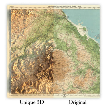
For something truly unique, this map is also available in "Unique 3D", our trademarked process that dramatically transforms the map so that it has a wonderful sense of depth. We combine the original map with detailed topography and elevation data, so that mountains and the terrain really "pop". For more info and examples of 3D maps, check my Unique 3D page.
For most orders, delivery time is about 3 working days. Personalised and customised products take longer, as I have to do the personalisation and send it to you for approval, which usually takes 1 or 2 days.
Please note that very large framed orders usually take longer to make and deliver.
If you need your order to arrive by a certain date, please contact me before you order so that we can find the best way of making sure you get your order in time.
I print and frame maps and artwork in 23 countries around the world. This means your order will be made locally, which cuts down on delivery time and ensures that it won't be damaged during delivery. You'll never pay customs or import duty, and we'll put less CO2 into the air.
All of my maps and art prints are well packaged and sent in a rugged tube if unframed, or surrounded by foam if framed.
I try to send out all orders within 1 or 2 days of receiving your order, though some products (like face masks, mugs and tote bags) can take longer to make.
If you select Express Delivery at checkout your order we will prioritise your order and send it out by 1-day courier (Fedex, DHL, UPS, Parcelforce).
Next Day delivery is also available in some countries (US, UK, Singapore, UAE) but please try to order early in the day so that we can get it sent out on time.
My standard frame is a gallery style black ash hardwood frame. It is simple and quite modern looking. My standard frame is around 20mm (0.8in) wide.
I use super-clear acrylic (perspex/acrylite) for the frame glass. It's lighter and safer than glass - and it looks better, as the reflectivity is lower.
Six standard frame colours are available for free (black, dark brown, dark grey, oak, white and antique gold). Custom framing and mounting/matting is available if you're looking for something else.
Most maps, art and illustrations are also available as a framed canvas. We use matte (not shiny) cotton canvas, stretch it over a sustainably sourced box wood frame, and then 'float' the piece within a wood frame. The end result is quite beautiful, and there's no glazing to get in the way.
All frames are provided "ready to hang", with either a string or brackets on the back. Very large frames will have heavy duty hanging plates and/or a mounting baton. If you have any questions, please get in touch.
See some examples of my framed maps and framed canvas maps.
Alternatively, I can also supply old maps and artwork on canvas, foam board, cotton rag and other materials.
If you want to frame your map or artwork yourself, please read my size guide first.
My maps are extremely high quality reproductions of original maps.
I source original, rare maps from libraries, auction houses and private collections around the world, restore them at my London workshop, and then use specialist giclée inks and printers to create beautiful maps that look even better than the original.
My maps are printed on acid-free archival matte (not glossy) paper that feels very high quality and almost like card. In technical terms the paper weight/thickness is 10mil/200gsm. It's perfect for framing.
I print with Epson ultrachrome giclée UV fade resistant pigment inks - some of the best inks you can find.
I can also make maps on canvas, cotton rag and other exotic materials.
Learn more about The Unique Maps Co.
Map personalisation
If you're looking for the perfect anniversary or housewarming gift, I can personalise your map to make it truly unique. For example, I can add a short message, or highlight an important location, or add your family's coat of arms.
The options are almost infinite. Please see my map personalisation page for some wonderful examples of what's possible.
To order a personalised map, select "personalise your map" before adding it to your basket.
Get in touch if you're looking for more complex customisations and personalisations.
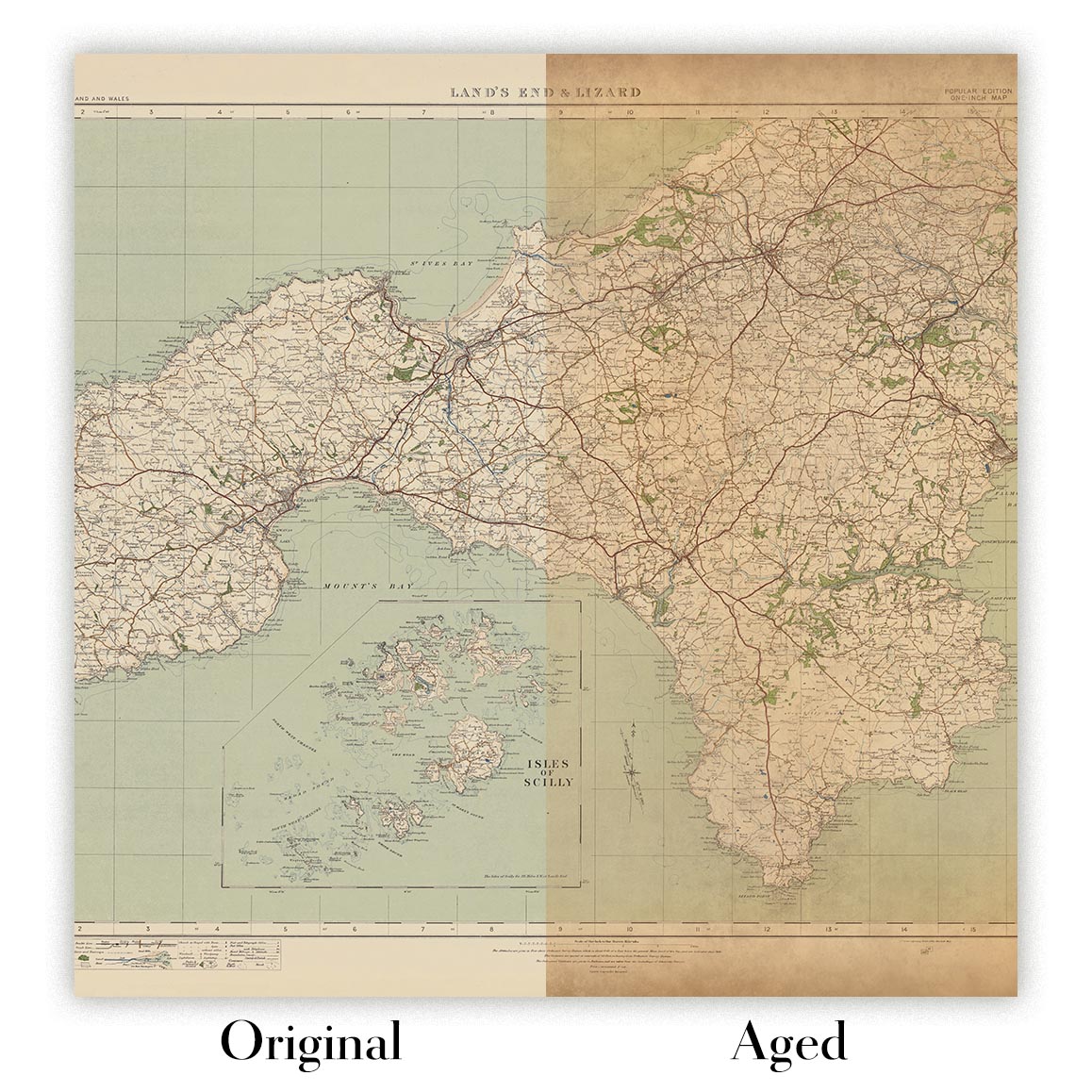
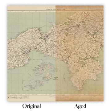
Map ageing
I have been asked hundreds of times over the years by customers if they could buy a map that looks even older.
Well, now you can, by selecting Aged before you add a map to your basket.
All the product photos you see on this page show the map in its Original form. This is what the map looks like today.
If you select Aged, I will age your map by hand, using a special and unique process developed through years of studying old maps, talking to researchers to understand the chemistry of aging paper, and of course... lots of practice!
If you're unsure, stick to the Original colour of the map. If you want something a bit darker and older looking, go for Aged.
If you are not happy with your order for any reason, contact me for a no-quibble refund.
I am very confident you will like your restored map or art print. I have been doing this since 1984. I'm a 5-star Etsy seller. I have sold tens of thousands of maps and art prints and have over 4,000 real 5-star reviews.
I use a unique process to restore maps and artwork that is massively time consuming and labour intensive. Hunting down the original maps and illustrations can take months. I use state of the art and eye-wateringly expensive technology to scan and restore them. As a result, I guarantee my maps and art prints are a cut above the rest - that's why I can offer a no-quibble refund.
Almost all of my maps and art prints look amazing at large sizes (200cm, 6.5ft+) and I can frame and deliver them to you as well, via special oversized courier. Contact me to discuss your specific needs.


Or try searching for something!


