

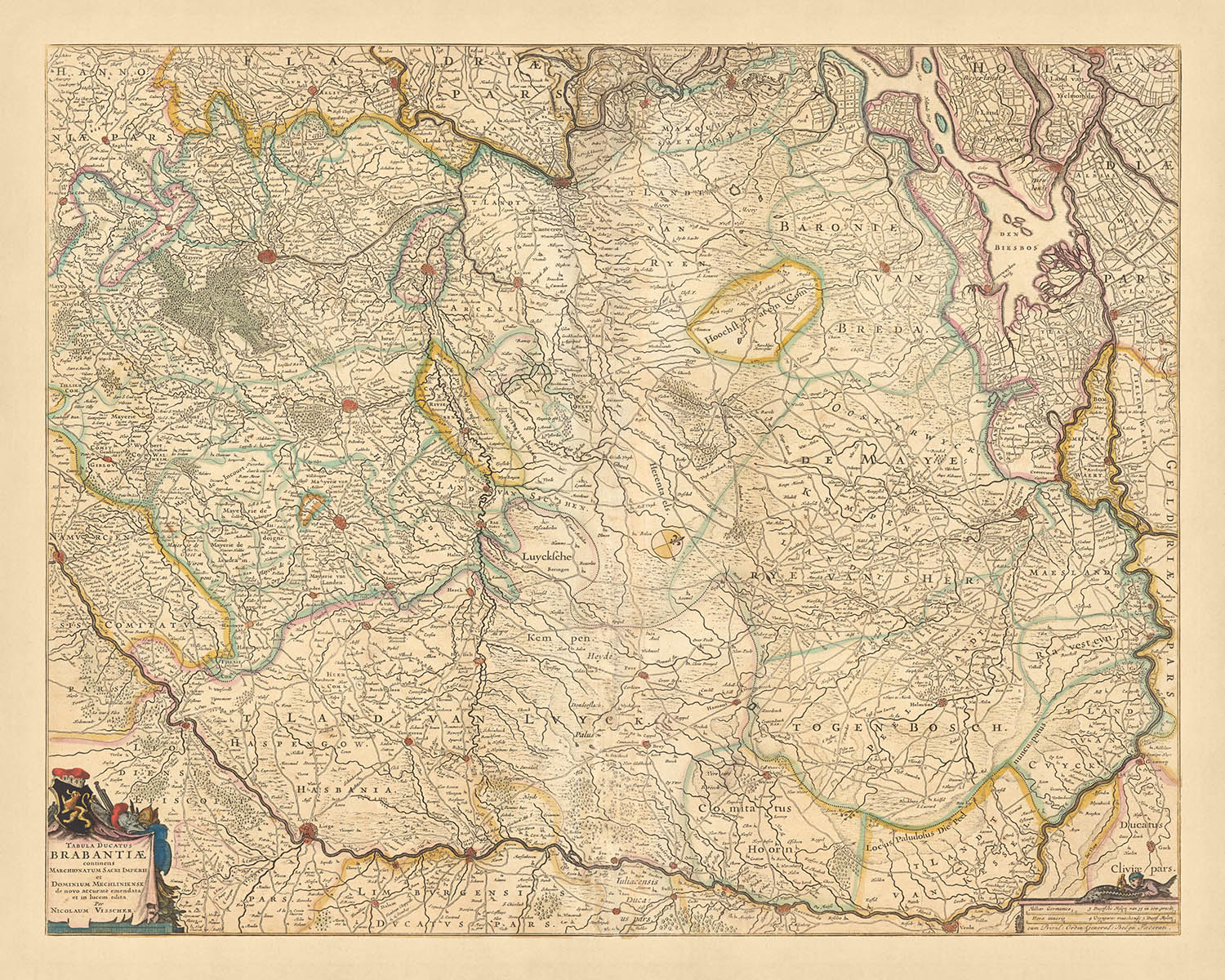

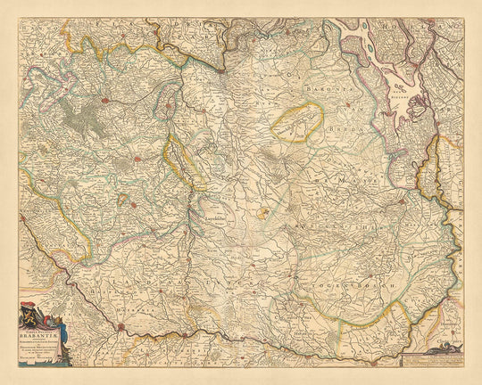


Old Map of Duchy of Brabant by Visscher, 1690: Brussels, Antwerp, Liège, Eindhoven, Hoge Kempen National Park

-
![]() Handmade in the USA
Handmade in the USA
-
FREE worldwide delivery in 2-3 days ⓘ
Free delivery in 2-3 days
Your map should be delivered in 2-3 working days with free delivery, worldwide.
We make maps by hand locally in 23 countries, including the USA
![]() . If you're buying a gift for someone in another country, we will make the map locally to them.
. If you're buying a gift for someone in another country, we will make the map locally to them.You will never pay import tax or customs duty.
Express delivery is available at checkout which can reduce the delivery time to 1-2 days.
Please note that personalised maps, and larger framed maps, can take longer to produce and deliver.
If you need your order to arrive by a certain date, contact me and we can discuss your options.
-
90 day money back guarantee
ⓘ
90 days to return and refund
Products can be returned within 90 days for a full refund, or exchange for another product.
For personalised or custom made items, we may offer you store credit or a non-expiring gift card, as we cannot resell personalised orders.
If you have any questions, get in touch. For more information, see our full returns & exchanges policy.

My maps are rare, museum-grade, restored old maps sourced from libraries, auction houses and private collections across the globe.
Framing & free personalisation available
1. Select your size
2. Frame & personalize your map
Make your map unique with framing, hand-drawn customisation, vintage ageing, pop art text, unique 3D styling and moreGift message & custom finish

If you want to add a gift message, or a finish (jigsaw, aluminium board, etc.) that is not available here, please request it in the "order note" when you check out.
Every order is custom made, so if you need the size adjusted slightly, or printed on an unusual material, just let us know. We've done thousands of custom orders over the years, so there's (almost) nothing we can't manage.
You can also contact us before you order, if you prefer!

- Handmade locally. No import duty or tax
- FREE Delivery. Arrives in 2-3 days
- Love it or your money back
- Questions? WhatsApp me any time
Own a piece of history
5,000+ 5 star reviews


Immerse yourself in the historical richness of the 'Tabula Ducatus Brabantiae continens Marchionatum Sacri Imperii et Dominium Mechliniense', a captivating map crafted by Nicolaes Visscher II in 1690. Translated into English, the title reads 'Map of the Duchy of Brabant, containing the Marquisate of the Holy Roman Empire and the Dominion of Mechlin'. The focus of this map is the Duchy of Brabant, an area that today encompasses parts of Belgium and the Netherlands. The map is a testament to the Dutch Golden Age, a period when the Dutch were pioneers in cartography and exploration.
As you delve into the map, you'll find yourself drawn to the intricate details of the cities and landmarks. The map features Brussels, the bustling capital of Belgium, known for its historic Grand Place and iconic Atomium. Antwerp, a port city on Belgium's River Scheldt, is also highlighted, with its diamond district and Flemish Renaissance architecture. The map also includes Liège, a city on the Meuse River in Belgium's French-speaking Wallonia region, and Eindhoven, a vibrant city in the province of North Brabant in the south Netherlands.
The map also brings to life the Hoge Kempen National Park, a unique nature reserve located in the Belgian province of Limburg. As you explore the map, you'll also notice the detailed depiction of fortifications, towns, roads, waterways, canals, and landmarks. The map includes decorative title and scale bar cartouches and a compass rose, adding to its charm and appeal.
The 'Tabula Ducatus Brabantiae continens Marchionatum Sacri Imperii et Dominium Mechliniense' is more than just a map; it's a journey through time, taking you back to the late 17th century. The hand-colored outlines and engraved details showcase the map's meticulous craftsmanship. The relief shown pictorially further enhances the map's visual appeal. Whether you're a history enthusiast, a lover of cartography, or simply someone who appreciates fine art, this map is a treasure trove of historical and geographical insights.
Some of the significant locations shown on this map:
Duchy of Brabant
- Brussels: Known as Bruxelles in French and Brussel in Dutch, it's the capital city of Belgium and the de facto capital of the European Union.
- Antwerp: Historically known as Antwerpen in Dutch, it's a significant city located on the River Scheldt with a strong reputation in diamond trading.
- Leuven: Known as Louvain in French, it's home to the oldest Catholic university in the world, the University of Leuven, founded in 1425.
- Mechelen: Known as Malines in French, it was a prominent city in the Middle Ages due to its proximity to the capital.
- Tienen: Known as Tirlemont in French, it's famous for its sugar refinery.
- Herentals: Known for its textile and metal industry in the 17th century.
- Lier: Known as Lierre in French, it's famous for its lace.
- Turnhout: Notable for its playing card industry.
- Hoogstraten: Known for its cultivation of strawberries.
- Geel: Known for its early implementation of deinstitutionalization in mental health care.
- Diest: Known for its beer, Diestse Tripel.
- Zoutleeuw: Known as Léau in French, it was an important center of trade in the Middle Ages.
- Sint-Truiden: Known for its historical buildings and fruit production.
- Hasselt: Known for its jenever, a type of gin.
- Genk: Became one of the most important industrial centers in Belgium in the 20th century.
Marquisate of the Holy Roman Empire
- Aachen: Known as Aken in Dutch and Aix-la-Chapelle in French, it's the westernmost city of Germany, where Charlemagne resided.
- Cologne: Known as Keulen in Dutch and Köln in German, it's one of the oldest cities in Germany.
- Düsseldorf: Known for its fashion industry and art scene.
- Duisburg: Known for its large harbor, the largest inland port in the world.
- Bonn: Known as the birthplace of Beethoven.
- Münster: Known for the signing of the Peace of Westphalia ending the Thirty Years' War in 1648.
- Dortmund: Known for its coal, steel, and beer.
- Essen: Known for the Zollverein Coal Mine Industrial Complex.
- Bochum: Known for its theater, the Schauspielhaus Bochum.
- Wuppertal: Known for its suspended monorail, the Wuppertaler Schwebebahn.
Dominium Mechliniense
- Mechelen: Known as Malines in French, it was a prominent city in the Middle Ages due to its proximity to the capital.
- Lier: Known as Lierre in French, it's famous for its lace.
- Herentals: Known for its textile and metal industry in the 17th century.
- Turnhout: Notable for its playing card industry.
- Geel: Known for its early implementation of deinstitutionalization in mental health care.
Notable boundaries and natural phenomena:
- The River Scheldt: An important waterway, connecting Antwerp to the North Sea.
- The River Meuse: One of the major European rivers, running through Belgium and the Netherlands.
- Hoge Kempen National Park: The first National Park in Belgium.
- The Ardennes: A region of extensive forests, rolling hills and ridges.
- The Eifel: A low mountain range in western Germany and eastern Belgium.
Notable historical events between 1600 and 1690:
- The Eighty Years' War (1568–1648): A revolt of the Seventeen Provinces against the political and religious hegemony of Philip II of Spain.
- The Treaty of Münster (1648): A part of the Peace of Westphalia, it ended the Eighty Years' War and marked the recognition of the independent Dutch Republic.
- The Franco-Dutch War (1672–1678): Also known as the Dutch War, it resulted in France becoming the predominant power in Europe.
Please double check the images to make sure that a specific town or place is shown on this map. You can also get in touch and ask us to check the map for you.
This map looks great at all sizes: 12x16in (30.5x41cm), 16x20in (40.5x51cm), 18x24in (45.5x61cm), 24x30in (61x76cm), 32x40in (81.5x102cm), 40x50in (102x127cm), 48x60in (122x153cm) and 56x70in (142x178cm), but it looks even better when printed large.
I can create beautiful, large prints of this map up to 90in (229cm). Please get in touch if you're looking for larger, customised or different framing options.
The model in the listing images is holding the 16x20in (40.5x51cm) version of this map.
The fifth listing image shows an example of my map personalisation service.
If you’re looking for something slightly different, check out my collection of the best old maps of Europe and European cities to see if something else catches your eye.
Please contact me to check if a certain location, landmark or feature is shown on this map.
This would make a wonderful birthday, Christmas, Father's Day, work leaving, anniversary or housewarming gift for someone from the areas covered by this map.
This map is available as a giclée print on acid free archival matte paper, or you can buy it framed. The frame is a nice, simple black frame that suits most aesthetics. Please get in touch if you'd like a different frame colour or material. My frames are glazed with super-clear museum-grade acrylic (perspex/acrylite), which is significantly less reflective than glass, safer, and will always arrive in perfect condition.
This map is also available as a float framed canvas, sometimes known as a shadow gap framed canvas or canvas floater. The map is printed on artist's cotton canvas and then stretched over a handmade box frame. We then "float" the canvas inside a wooden frame, which is available in a range of colours (black, dark brown, oak, antique gold and white). This is a wonderful way to present a map without glazing in front. See some examples of float framed canvas maps and explore the differences between my different finishes.
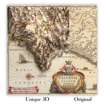
For something truly unique, this map is also available in "Unique 3D", our trademarked process that dramatically transforms the map so that it has a wonderful sense of depth. We combine the original map with detailed topography and elevation data, so that mountains and the terrain really "pop". For more info and examples of 3D maps, check my Unique 3D page.
For most orders, delivery time is about 3 working days. Personalised and customised products take longer, as I have to do the personalisation and send it to you for approval, which usually takes 1 or 2 days.
Please note that very large framed orders usually take longer to make and deliver.
If you need your order to arrive by a certain date, please contact me before you order so that we can find the best way of making sure you get your order in time.
I print and frame maps and artwork in 23 countries around the world. This means your order will be made locally, which cuts down on delivery time and ensures that it won't be damaged during delivery. You'll never pay customs or import duty, and we'll put less CO2 into the air.
All of my maps and art prints are well packaged and sent in a rugged tube if unframed, or surrounded by foam if framed.
I try to send out all orders within 1 or 2 days of receiving your order, though some products (like face masks, mugs and tote bags) can take longer to make.
If you select Express Delivery at checkout your order we will prioritise your order and send it out by 1-day courier (Fedex, DHL, UPS, Parcelforce).
Next Day delivery is also available in some countries (US, UK, Singapore, UAE) but please try to order early in the day so that we can get it sent out on time.
My standard frame is a gallery style black ash hardwood frame. It is simple and quite modern looking. My standard frame is around 20mm (0.8in) wide.
I use super-clear acrylic (perspex/acrylite) for the frame glass. It's lighter and safer than glass - and it looks better, as the reflectivity is lower.
Six standard frame colours are available for free (black, dark brown, dark grey, oak, white and antique gold). Custom framing and mounting/matting is available if you're looking for something else.
Most maps, art and illustrations are also available as a framed canvas. We use matte (not shiny) cotton canvas, stretch it over a sustainably sourced box wood frame, and then 'float' the piece within a wood frame. The end result is quite beautiful, and there's no glazing to get in the way.
All frames are provided "ready to hang", with either a string or brackets on the back. Very large frames will have heavy duty hanging plates and/or a mounting baton. If you have any questions, please get in touch.
See some examples of my framed maps and framed canvas maps.
Alternatively, I can also supply old maps and artwork on canvas, foam board, cotton rag and other materials.
If you want to frame your map or artwork yourself, please read my size guide first.
My maps are extremely high quality reproductions of original maps.
I source original, rare maps from libraries, auction houses and private collections around the world, restore them at my London workshop, and then use specialist giclée inks and printers to create beautiful maps that look even better than the original.
My maps are printed on acid-free archival matte (not glossy) paper that feels very high quality and almost like card. In technical terms the paper weight/thickness is 10mil/200gsm. It's perfect for framing.
I print with Epson ultrachrome giclée UV fade resistant pigment inks - some of the best inks you can find.
I can also make maps on canvas, cotton rag and other exotic materials.
Learn more about The Unique Maps Co.
Map personalisation
If you're looking for the perfect anniversary or housewarming gift, I can personalise your map to make it truly unique. For example, I can add a short message, or highlight an important location, or add your family's coat of arms.
The options are almost infinite. Please see my map personalisation page for some wonderful examples of what's possible.
To order a personalised map, select "personalise your map" before adding it to your basket.
Get in touch if you're looking for more complex customisations and personalisations.
Map ageing
I have been asked hundreds of times over the years by customers if they could buy a map that looks even older.
Well, now you can, by selecting Aged before you add a map to your basket.
All the product photos you see on this page show the map in its Original form. This is what the map looks like today.
If you select Aged, I will age your map by hand, using a special and unique process developed through years of studying old maps, talking to researchers to understand the chemistry of aging paper, and of course... lots of practice!
If you're unsure, stick to the Original colour of the map. If you want something a bit darker and older looking, go for Aged.
If you are not happy with your order for any reason, contact me for a no-quibble refund. Please see our returns and refund policy for more information.
I am very confident you will like your restored map or art print. I have been doing this since 1984. I'm a 5-star Etsy seller. I have sold tens of thousands of maps and art prints and have over 5,000 real 5-star reviews.
I use a unique process to restore maps and artwork that is massively time consuming and labour intensive. Hunting down the original maps and illustrations can take months. I use state of the art and eye-wateringly expensive technology to scan and restore them. As a result, I guarantee my maps and art prints are a cut above the rest - that's why I can offer a no-quibble refund.
Almost all of my maps and art prints look amazing at large sizes (200cm, 6.5ft+) and I can frame and deliver them to you as well, via special oversized courier. Contact me to discuss your specific needs.
Or try searching for something!


