


Old Map of the Battle of Long Island, 1776: American Revolution, British Landing

-
![]() Handmade in the USA
Handmade in the USA
-
FREE worldwide delivery in 2-3 days ⓘ
Free delivery in 2-3 days
Your map should be delivered in 2-3 working days with free delivery, worldwide.
We make maps by hand locally in 23 countries, including the USA
![]() . If you're buying a gift for someone in another country, we will make the map locally to them.
. If you're buying a gift for someone in another country, we will make the map locally to them.You will never pay import tax or customs duty.
Express delivery is available at checkout which can reduce the delivery time to 1-2 days.
Please note that personalised maps, and larger framed maps, can take longer to produce and deliver.
If you need your order to arrive by a certain date, contact me and we can discuss your options.
-
90 day money back guarantee ⓘ
90 days to return and refund
Products can be returned within 90 days for a full refund, or exchange for another product.
For personalised or custom made items, we may offer you a non-expiring gift card, as we cannot resell personalised orders.
If you have any questions, get in touch. For more information, see our full returns & exchanges policy.

My maps are rare, museum-grade, restored old maps sourced from libraries, auction houses and private collections across the globe.
Framing & free personalisation available
1. Select your size
2. Customise your map
Personalise your map with framing, hand-drawn customisation, vintage ageing, pop art text, unique 3D styling and moreGift message & custom finish

If you want to add a gift message, or a finish (jigsaw, aluminium board, etc.) that is not available here, please request it in the "order note" when you check out.
Every order is custom made, so if you need the size adjusted slightly, or printed on an unusual material, just let us know. We've done thousands of custom orders over the years, so there's (almost) nothing we can't manage.
You can also contact us before you order, if you prefer!

- Handmade locally. No import duty or tax
- FREE Delivery. Arrives in 2-3 days
- Love it or your money back
- Questions? WhatsApp me any time
Own a piece of history
5,000+ 5 star reviews


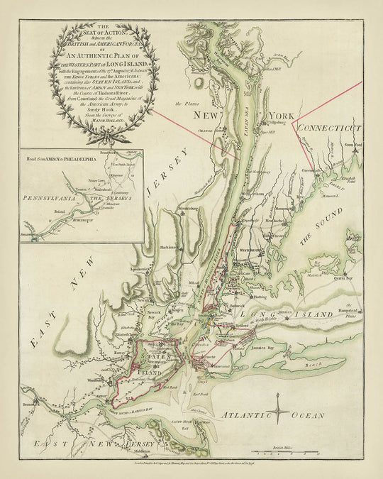
Step into the rich history of the American Revolution with this exquisite 1776 map, "The Seat of Action between the British and American Forces." Crafted by the renowned mapmakers Sayer & Bennett, this detailed cartographic masterpiece captures one of the pivotal early battles of the war—the Battle of Long Island. The map vividly illustrates the strategic maneuvers and military engagements between the British and American forces, providing a fascinating glimpse into the tactical complexities of the era.
The map is not just a geographical representation but a dynamic infographic that conveys the unfolding drama of the battle. It meticulously charts the British landing at Gravesend Bay, the American defensive lines along Gowanus Heights, and the crucial flanking maneuver through Jamaica Pass. The visual narrative is enhanced by annotations and symbols that highlight key military positions, troop movements, and the eventual American retreat to Brooklyn. This level of detail offers a compelling insight into the strategic thinking and challenges faced by both sides.
Adding to its historical significance, the map is based on the surveys of Major Samuel Holland, a prominent figure in 18th-century cartography. Holland's expertise ensured the map's accuracy and detail, making it an invaluable resource for understanding the geographical and tactical elements of the battle. Sayer & Bennett's publication of this map shortly after the battle underscores its importance as a contemporary record of a critical moment in the Revolutionary War.
The map also serves as a rich repository of geographical information, extending from Courtland on the Hudson River to Sandy Hook and Middletown in New Jersey. It features towns, settlements, roads, and topographical details, providing a comprehensive view of the region during the late 18th century. The inclusion of the British fleet in New York Bay and the American fortifications on Long Island and Manhattan further enriches the map's narrative, offering a holistic view of the military and naval aspects of the conflict.
This map is a testament to the artistry and precision of 18th-century cartography, blending historical narrative with geographical detail. It stands as a valuable artifact for historians, collectors, and anyone with a passion for the American Revolution. The map's intricate design and historical context make it a captivating addition to any collection, offering a window into the strategic and geographical landscape of one of America's most defining conflicts.
Places on this map
- New York City
- Long Island
- Staten Island
- New Jersey
- Connecticut
- Hudson River
- East River
- The Sound
- Atlantic Ocean
- Gravesend Bay
- Gowanus Heights
- Brooklyn
- Manhattan
- Sandy Hook
- Middletown
- Courtland
- Amboy
- Philadelphia
- Newark Bay
- Hackinsack
- New Rochelle
- Stamford
- Hempstead Plains
- Jamaica Pass
- Greenwich
- White Plains
- Tappan Sea
- Haverstraw
- Poughkeepsie
- Esopus
Notable Features & Landmarks
- British landing site: Gravesend Bay in eastern Long Island.
- American defensive lines: Stretching from the shore eastward along Gowanus Heights.
- British troop movements: Two columns attacking American forces and the main thrust through Jamaica Pass.
- American retreat: To fortifications at the village of Brooklyn on the East River.
- Assembled British fleet: In New York Bay.
- Geographical features: Major towns, settlements, roads, and residences.
- Inset map: Showing the road from Amboy to Philadelphia.
- Topographical details: Including rivers, bays, and hills.
- Military positions: Both British and American positions are marked.
- Key locations: Such as Manhattan, Long Island, Staten Island, and parts of New Jersey.
- Water bodies: Hudson River, East River, The Sound, and the Atlantic Ocean.
- Historical context: The map was published soon after the battle, reflecting the immediate aftermath and strategic movements.
- Cartographic details: Based on Major Holland's surveys, providing accuracy and detail.
- Map legend: Explaining symbols and markings used on the map.
- Compass rose: Indicating directions on the map.
- Scale bar: For measuring distances on the map.
- Annotations: Describing key events and movements during the battle.
- Historical narrative: The map tells the story of the Battle of Long Island through visual representation.
- British strategy: Illustrated through the depiction of troop movements and landings.
- American fortifications: Shown in Brooklyn and other strategic points.
- Naval presence: Depicting the British fleet's strategic positioning.
- Geopolitical boundaries: Indicating the borders of New York, New Jersey, and Connecticut.
- Historical landmarks: Important sites related to the battle and the Revolutionary War.
- Visual style: Reflects the artistic and cartographic conventions of the late 18th century.
Historical and design context
- Name of the map: The Seat of Action between the British and American Forces. Or an Authentic Plan of the Western Part of Long Island, With the engagement of the 27th August 1776 Between the Kings Forces and the Americans . . . from Surveys of Major Holland.
- Date of creation: 1776
- Mapmaker or publisher: Sayer & Bennett
- Interesting context about the mapmaker: Sayer & Bennett were prominent map publishers in the 18th century, known for producing detailed and accurate maps. They published this map soon after the Battle of Long Island, and it likely competed with William Faden's map of the same event.
- Historical significance:
- Battle of Long Island: The map depicts the Battle of Long Island, one of the early and significant battles of the American Revolution.
- British strategy: The map illustrates the British strategy to cut off New England and gain control of the lower Hudson, aiming to isolate and overpower the northern colonies.
- American retreat: It documents the American forces' retreat to Brooklyn and their subsequent evacuation to Manhattan, a critical moment in the battle.
- Topics and themes shown on the map:
- Military positions and movements: The map shows the British landing, troop movements, and the American defensive positions.
- Geographical features: It includes towns, settlements, major topographical features, roads, and residences.
- Naval presence: The assembled British fleet in New York Bay is depicted.
- Countries and regions shown on the map:
- United States: The map focuses on the area around New York City, including parts of New Jersey, Long Island, and Connecticut.
- Design or style of the map:
- Infographic thematic map: It conveys detailed information about the battle and troop movements in an illustrative manner.
- Historical cartography: The map was based on surveys by Major Holland and reflects the cartographic style of the late 18th century.
- Additional context:
- British evacuation of Boston: The map follows the British retreat from Boston and their subsequent strategy to control New York.
- Strategic importance of New York: The map highlights New York's significance in the British plan to dominate the northern colonies.
Please double check the images to make sure that a specific town or place is shown on this map. You can also get in touch and ask us to check the map for you.
This map looks great at every size, but I always recommend going for a larger size if you have space. That way you can easily make out all of the details.
This map looks amazing at sizes all the way up to 70in (180cm). If you are looking for a larger map, please get in touch.
Please note: the labels on this map are hard to read if you order a map that is 20in (50cm) or smaller. The map is still very attractive, but if you would like to read the map easily, please buy a larger size.
The model in the listing images is holding the 16x20in (40x50cm) version of this map.
The fifth listing image shows an example of my map personalisation service.
If you’re looking for something slightly different, check out my collection of the best old maps to see if something else catches your eye.
Please contact me to check if a certain location, landmark or feature is shown on this map.
This would make a wonderful birthday, Christmas, Father's Day, work leaving, anniversary or housewarming gift for someone from the areas covered by this map.
This map is available as a giclée print on acid free archival matte paper, or you can buy it framed. The frame is a nice, simple black frame that suits most aesthetics. Please get in touch if you'd like a different frame colour or material. My frames are glazed with super-clear museum-grade acrylic (perspex/acrylite), which is significantly less reflective than glass, safer, and will always arrive in perfect condition.
This map is also available as a float framed canvas, sometimes known as a shadow gap framed canvas or canvas floater. The map is printed on artist's cotton canvas and then stretched over a handmade box frame. We then "float" the canvas inside a wooden frame, which is available in a range of colours (black, dark brown, oak, antique gold and white). This is a wonderful way to present a map without glazing in front. See some examples of float framed canvas maps and explore the differences between my different finishes.
For something truly unique, this map is also available in "Unique 3D", our trademarked process that dramatically transforms the map so that it has a wonderful sense of depth. We combine the original map with detailed topography and elevation data, so that mountains and the terrain really "pop". For more info and examples of 3D maps, check my Unique 3D page.
For most orders, delivery time is about 3 working days. Personalised and customised products take longer, as I have to do the personalisation and send it to you for approval, which usually takes 1 or 2 days.
Please note that very large framed orders usually take longer to make and deliver.
If you need your order to arrive by a certain date, please contact me before you order so that we can find the best way of making sure you get your order in time.
I print and frame maps and artwork in 23 countries around the world. This means your order will be made locally, which cuts down on delivery time and ensures that it won't be damaged during delivery. You'll never pay customs or import duty, and we'll put less CO2 into the air.
All of my maps and art prints are well packaged and sent in a rugged tube if unframed, or surrounded by foam if framed.
I try to send out all orders within 1 or 2 days of receiving your order, though some products (like face masks, mugs and tote bags) can take longer to make.
If you select Express Delivery at checkout your order we will prioritise your order and send it out by 1-day courier (Fedex, DHL, UPS, Parcelforce).
Next Day delivery is also available in some countries (US, UK, Singapore, UAE) but please try to order early in the day so that we can get it sent out on time.
My standard frame is a gallery style black ash hardwood frame. It is simple and quite modern looking. My standard frame is around 20mm (0.8in) wide.
I use super-clear acrylic (perspex/acrylite) for the frame glass. It's lighter and safer than glass - and it looks better, as the reflectivity is lower.
Six standard frame colours are available for free (black, dark brown, dark grey, oak, white and antique gold). Custom framing and mounting/matting is available if you're looking for something else.
Most maps, art and illustrations are also available as a framed canvas. We use matte (not shiny) cotton canvas, stretch it over a sustainably sourced box wood frame, and then 'float' the piece within a wood frame. The end result is quite beautiful, and there's no glazing to get in the way.
All frames are provided "ready to hang", with either a string or brackets on the back. Very large frames will have heavy duty hanging plates and/or a mounting baton. If you have any questions, please get in touch.
See some examples of my framed maps and framed canvas maps.
Alternatively, I can also supply old maps and artwork on canvas, foam board, cotton rag and other materials.
If you want to frame your map or artwork yourself, please read my size guide first.
My maps are extremely high quality reproductions of original maps.
I source original, rare maps from libraries, auction houses and private collections around the world, restore them at my London workshop, and then use specialist giclée inks and printers to create beautiful maps that look even better than the original.
My maps are printed on acid-free archival matte (not glossy) paper that feels very high quality and almost like card. In technical terms the paper weight/thickness is 10mil/200gsm. It's perfect for framing.
I print with Epson ultrachrome giclée UV fade resistant pigment inks - some of the best inks you can find.
I can also make maps on canvas, cotton rag and other exotic materials.
Learn more about The Unique Maps Co.
Map personalisation
If you're looking for the perfect anniversary or housewarming gift, I can personalise your map to make it truly unique. For example, I can add a short message, or highlight an important location, or add your family's coat of arms.
The options are almost infinite. Please see my map personalisation page for some wonderful examples of what's possible.
To order a personalised map, select "personalise your map" before adding it to your basket.
Get in touch if you're looking for more complex customisations and personalisations.
Map ageing
I have been asked hundreds of times over the years by customers if they could buy a map that looks even older.
Well, now you can, by selecting Aged before you add a map to your basket.
All the product photos you see on this page show the map in its Original form. This is what the map looks like today.
If you select Aged, I will age your map by hand, using a special and unique process developed through years of studying old maps, talking to researchers to understand the chemistry of aging paper, and of course... lots of practice!
If you're unsure, stick to the Original colour of the map. If you want something a bit darker and older looking, go for Aged.
If you are not happy with your order for any reason, contact me for a no-quibble refund. Please see our returns and refund policy for more information.
I am very confident you will like your restored map or art print. I have been doing this since 1984. I'm a 5-star Etsy seller. I have sold tens of thousands of maps and art prints and have over 5,000 real 5-star reviews.
I use a unique process to restore maps and artwork that is massively time consuming and labour intensive. Hunting down the original maps and illustrations can take months. I use state of the art and eye-wateringly expensive technology to scan and restore them. As a result, I guarantee my maps and art prints are a cut above the rest - that's why I can offer a no-quibble refund.
Almost all of my maps and art prints look amazing at large sizes (200cm, 6.5ft+) and I can frame and deliver them to you as well, via special oversized courier. Contact me to discuss your specific needs.
Or try searching for something!


