


Old Map of Pennsylvania by H. S. Tanner, 1836,: Philadelphia, Pittsburgh, Allentown, Erie, Reading, Roads, Railway, Canals

-
![]() Handmade in the USA
Handmade in the USA
-
FREE Christmas delivery in 3-4 days ⓘ
Free Christmas delivery in 3-4 days
Your map should be delivered in 3-4 working days with free delivery, worldwide.
We make maps by hand locally in 23 countries, including the USA
![]() . If you're buying a gift for someone in another country, we will make the map locally to them.
. If you're buying a gift for someone in another country, we will make the map locally to them.You will never pay import tax or customs duty.
Check the Christmas delivery guide for order deadlines. Delivery times are starting to slow down, and will continue to slow down towards Christmas.
Express delivery is available at checkout which can reduce the delivery time to 1-2 days.
Please note that personalised maps, and larger framed maps, can take longer to produce and deliver.
If you need your order to arrive by a certain date, contact me and we can discuss your options.
-
90 day money back guarantee
ⓘ
90 days to return and refund
Products can be returned within 90 days for a full refund, or exchange for another product.
For personalised and custom made items, we may offer you store credit or a non-expiring gift card, as we cannot resell personalised orders.
If you have any questions, get in touch. For more information, see our full returns & exchanges policy.

My maps are rare, museum-grade, restored old maps sourced from libraries, auction houses and private collections across the globe.
Framing & free personalisation available
1. Select your size
2. Frame & personalize your map
There is limited framing & personalisation capacity available. Order soon for Christmas delivery.


Gift message & custom finish

If you want to add a gift message, or a finish (jigsaw, aluminium board, etc.) that is not available here, please request it in the "order note" when you check out.
Every order is custom made, so if you need the size adjusted slightly, or printed on an unusual material, just let us know. We've done thousands of custom orders over the years, so there's (almost) nothing we can't manage.
You can also contact us before you order, if you prefer!

- Handmade locally. No import duty or tax
- FREE Delivery by Christmas
- Love it or your money back (90 days)
- Questions? WhatsApp me any time
Own a piece of history
5,000+ 5 star reviews


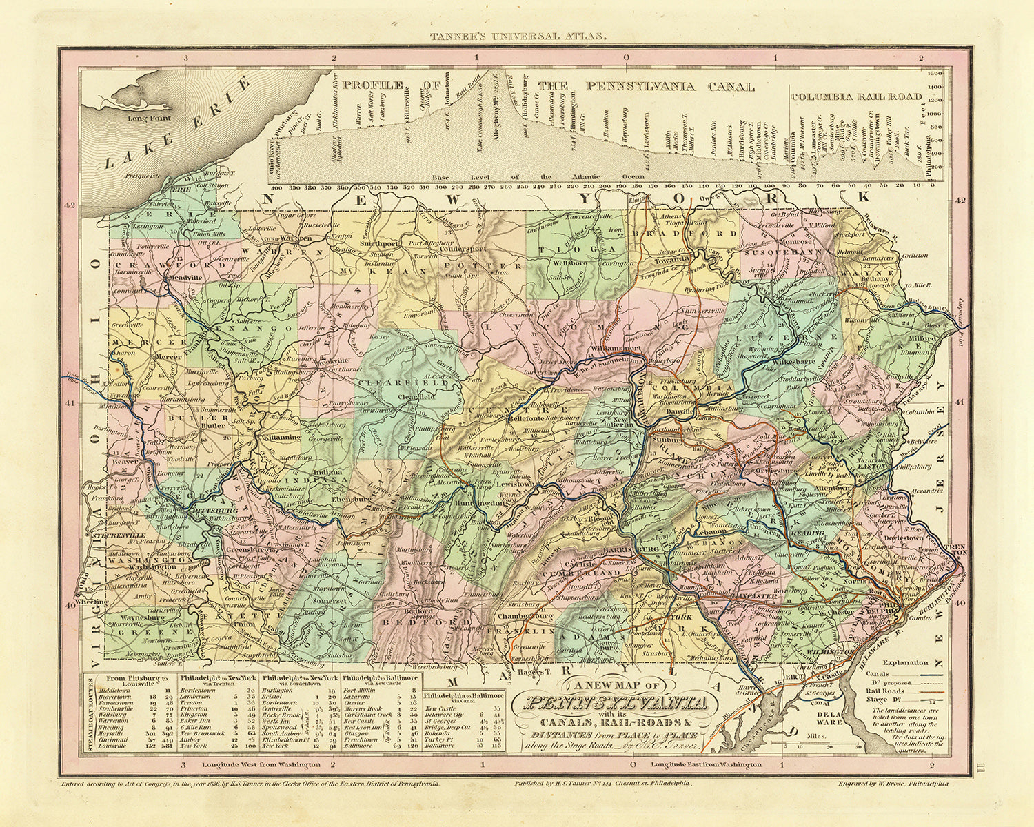
Step back in time and explore the rich history of Pennsylvania with this meticulously crafted old map by H. S. Tanner. Published in 1836, this remarkable piece showcases the state during a period of rapid growth and transformation. Uncover the intricate network of canals, roads, and railroads, along with accurate distances, that laid the foundation for Pennsylvania's emergence as an industrial powerhouse. This map is a testament to Tanner's cartographic prowess and offers a captivating window into the past, making it a must-have for history enthusiasts, cartography aficionados, and Pennsylvania natives alike.
Delve into a bygone era as you trace the development of Pennsylvania through its vibrant towns, cities, counties, settlements, and colonies that thrived by 1830. From bustling metropolises to charming communities, each location tells a unique story of its founding and significance. Immerse yourself in the history of Pennsylvania with this carefully curated list of notable settlements, organized by modern-day population size:
Settlements (Founded Year):- Philadelphia (1682) - The birthplace of American independence and the nation's first capital.
- Pittsburgh (1758) - Once a strategic fort during the French and Indian War, it evolved into an industrial hub.
- Allentown (1762) - Known as the "City Without Limits," it flourished due to its location along major transportation routes.
- Erie (1795) - Situated on the shores of Lake Erie, it played a crucial role in early maritime trade and transportation.
- Reading (1748) - A center of industry and commerce, boasting a rich heritage in manufacturing and agriculture.
- Lancaster (1729) - Renowned for its captivating architecture, it served as the capital of Pennsylvania from 1799 to 1812.
- Scranton (1840) - Established amidst the flourishing coal industry, it would become a vital part of America's Industrial Revolution.
- Bethlehem (1741) - Originally a Moravian community, it grew into a vibrant town known for its steel and textile industries.
- Harrisburg (1785) - Pennsylvania's capital city, strategically located along the Susquehanna River.
- York (1741) - The site of the Continental Congress during the American Revolution, it played a significant role in shaping the nation.
- Altoona (1849) - Home to the famous Horseshoe Curve, a testament to the innovative engineering of the Pennsylvania Railroad.
- Wilkes-Barre (1769) - A prominent center for anthracite coal mining and early manufacturing.
- Williamsport (1806) - Known as the "Lumber Capital of the World" during the height of the timber industry.
- Easton (1752) - Situated at the confluence of the Delaware and Lehigh Rivers, it prospered as a vital transportation hub.
- Johnstown (1800) - Famed for its steel industry and tragically remembered for the devastating 1889 flood.
- West Chester (1786) - A charming town rich in history, featuring well-preserved architecture from the 18th and 19th centuries.
- Norristown (1784) - Boasting a rich colonial past, it became a significant center for industry and commerce.
- Lebanon (1740) - Founded by German immigrants, it has a strong agricultural heritage and historical significance.
- New Castle (1798) - Flourished due to the discovery of rich coal and iron deposits in the surrounding areas.
- Chambersburg (1764) - A frontier town that played a vital role in the American Revolution and the Civil War.
- Greensburg (1782) - Named after General Nathanael Greene, it evolved into a thriving industrial and commercial center.
- McKeesport (1795) - Situated at the confluence of the Monongahela and Youghiogheny Rivers, it became a vital transportation hub.
- Pottstown (1752) - Located along the Schuylkill River, it prospered as a manufacturing and industrial center.
- New Kensington (1891) - Established as a major industrial hub, it experienced rapid growth during the late 19th century.
- Butler (1803) - Named after General Richard Butler, it played a significant role in the development of the region's oil and gas industry.
- Bristol (1681) - Founded by Samuel Clifton, it played a vital role in early colonial trade and commerce.
- Carlisle (1751) - Known for its prestigious military academy and its historical association with the Carlisle Indian Industrial School.
- Beaver (1800) - Situated along the Ohio River, it became an important trade and transportation center.
- East Stroudsburg (1810) - Nestled in the picturesque Pocono Mountains, it serves as a gateway to outdoor recreational activities.
- Hazleton (1831) - Emerged as a prominent center for anthracite coal mining and industrial production.
Boundaries, Rivers, and Natural Phenomena:
- The majestic Appalachian Mountains traverse the eastern portion of Pennsylvania, offering stunning vistas and ample opportunities for hiking and exploration.
- The mighty Delaware River forms a part of Pennsylvania's eastern border, providing scenic beauty and opportunities for water-based activities.
- The Susquehanna River, the longest river on the American East Coast, flows through central Pennsylvania, offering breathtaking views and recreational possibilities.
- The historical boundaries of Pennsylvania encompassed regions that are now part of the states of Ohio, West Virginia, and Delaware.
Historical Events (1810-1840):
- The War of 1812, fought between the United States and the British Empire, had an impact on Pennsylvania, particularly its maritime trade and defense.
- The construction of the Pennsylvania Canal system, initiated in 1826, revolutionized transportation and fostered economic growth.
- The completion of the Allegheny Portage Railroad in 1834, a marvel of engineering, facilitated transportation across the Allegheny Mountains.
- The Great Fire of Pittsburgh in 1845 destroyed a significant portion of the city's downtown, leading to its subsequent rebuilding and expansion.
Embrace the past and explore the evolution of Pennsylvania with this captivating old map by H. S. Tanner. Uncover the fascinating details of canals, roads, railroads, and distances that played a pivotal role in shaping the state's history. This meticulously crafted piece is not only a stunning display of cartographic artistry but also a gateway to the stories and heritage of Pennsylvania's vibrant settlements.
Please double check the images to make sure that a specific town or place is shown on this map. You can also get in touch and ask us to check the map for you.
This map looks great at all sizes: 12x16in (30.5x41cm), 16x20in (40.5x51cm), 18x24in (45.5x61cm), 24x30in (61x76cm), 32x40in (81.5x102cm), 40x50in (102x127cm), 48x60in (122x153cm) and 56x70in (142x178cm), but it looks even better when printed large.
I can create beautiful, large prints of this map up to 100in (254cm). Please get in touch if you're looking for larger, customised or different framing options.
The model in the listing images is holding the 16x20in (40.5x51cm) version of this map.
The fifth listing image shows an example of my map personalisation service.
If you’re looking for something slightly different, check out my main collection of USA and North America maps.
Please contact me to check if a certain location, landmark or feature is shown on this map.
This would make a wonderful birthday, Christmas, Father's Day, work leaving, anniversary or housewarming gift for someone from the areas covered by this map.
This map is available as a giclée print on acid free archival matte paper, or you can buy it framed. The frame is a nice, simple black frame that suits most aesthetics. Please get in touch if you'd like a different frame colour or material. My frames are glazed with super-clear museum-grade acrylic (perspex/acrylite), which is significantly less reflective than glass, safer, and will always arrive in perfect condition.
This map is also available as a float framed canvas, sometimes known as a shadow gap framed canvas or canvas floater. The map is printed on artist's cotton canvas and then stretched over a handmade box frame. We then "float" the canvas inside a wooden frame, which is available in a range of colours (black, dark brown, oak, antique gold and white). This is a wonderful way to present a map without glazing in front. See some examples of float framed canvas maps and explore the differences between my different finishes.
For something truly unique, this map is also available in "Unique 3D", our trademarked process that dramatically transforms the map so that it has a wonderful sense of depth. We combine the original map with detailed topography and elevation data, so that mountains and the terrain really "pop". For more info and examples of 3D maps, check my Unique 3D page.
For most orders, delivery time is about 3 working days. Personalised and customised products take longer, as I have to do the personalisation and send it to you for approval, which usually takes 1 or 2 days.
Please note that very large framed orders usually take longer to make and deliver.
If you need your order to arrive by a certain date, please contact me before you order so that we can find the best way of making sure you get your order in time.
I print and frame maps and artwork in 23 countries around the world. This means your order will be made locally, which cuts down on delivery time and ensures that it won't be damaged during delivery. You'll never pay customs or import duty, and we'll put less CO2 into the air.
All of my maps and art prints are well packaged and sent in a rugged tube if unframed, or surrounded by foam if framed.
I try to send out all orders within 1 or 2 days of receiving your order, though some products (like face masks, mugs and tote bags) can take longer to make.
If you select Express Delivery at checkout your order we will prioritise your order and send it out by 1-day courier (Fedex, DHL, UPS, Parcelforce).
Next Day delivery is also available in some countries (US, UK, Singapore, UAE) but please try to order early in the day so that we can get it sent out on time.
My standard frame is a gallery style black ash hardwood frame. It is simple and quite modern looking. My standard frame is around 20mm (0.8in) wide.
I use super-clear acrylic (perspex/acrylite) for the frame glass. It's lighter and safer than glass - and it looks better, as the reflectivity is lower.
Six standard frame colours are available for free (black, dark brown, dark grey, oak, white and antique gold). Custom framing and mounting/matting is available if you're looking for something else.
Most maps, art and illustrations are also available as a framed canvas. We use matte (not shiny) cotton canvas, stretch it over a sustainably sourced box wood frame, and then 'float' the piece within a wood frame. The end result is quite beautiful, and there's no glazing to get in the way.
All frames are provided "ready to hang", with either a string or brackets on the back. Very large frames will have heavy duty hanging plates and/or a mounting baton. If you have any questions, please get in touch.
See some examples of my framed maps and framed canvas maps.
Alternatively, I can also supply old maps and artwork on canvas, foam board, cotton rag and other materials.
If you want to frame your map or artwork yourself, please read my size guide first.
My maps are extremely high quality reproductions of original maps.
I source original, rare maps from libraries, auction houses and private collections around the world, restore them at my London workshop, and then use specialist giclée inks and printers to create beautiful maps that look even better than the original.
My maps are printed on acid-free archival matte (not glossy) paper that feels very high quality and almost like card. In technical terms the paper weight/thickness is 10mil/200gsm. It's perfect for framing.
I print with Epson ultrachrome giclée UV fade resistant pigment inks - some of the best inks you can find.
I can also make maps on canvas, cotton rag and other exotic materials.
Learn more about The Unique Maps Co.
Map personalisation
If you're looking for the perfect anniversary or housewarming gift, I can personalise your map to make it truly unique. For example, I can add a short message, or highlight an important location, or add your family's coat of arms.
The options are almost infinite. Please see my map personalisation page for some wonderful examples of what's possible.
To order a personalised map, select "personalise your map" before adding it to your basket.
Get in touch if you're looking for more complex customisations and personalisations.
Map ageing
I have been asked hundreds of times over the years by customers if they could buy a map that looks even older.
Well, now you can, by selecting Aged before you add a map to your basket.
All the product photos you see on this page show the map in its Original form. This is what the map looks like today.
If you select Aged, I will age your map by hand, using a special and unique process developed through years of studying old maps, talking to researchers to understand the chemistry of aging paper, and of course... lots of practice!
If you're unsure, stick to the Original colour of the map. If you want something a bit darker and older looking, go for Aged.
If you are not happy with your order for any reason, contact me and I'll get it fixed ASAP, free of charge. Please see my returns and refund policy for more information.
I am very confident you will like your restored map or art print. I have been doing this since 1984. I'm a 5-star Etsy seller. I have sold tens of thousands of maps and art prints and have over 5,000 real 5-star reviews. My work has been featured in interior design magazines, on the BBC, and on the walls of dozens of 5-star hotels.
I use a unique process to restore maps and artwork that is massively time consuming and labour intensive. Hunting down the original maps and illustrations can take months. I use state of the art and eye-wateringly expensive technology to scan and restore them. As a result, I guarantee my maps and art prints are a cut above the rest. I stand by my products and will always make sure you're 100% happy with what you receive.
Almost all of my maps and art prints look amazing at large sizes (200cm, 6.5ft+) and I can frame and deliver them to you as well, via special oversized courier. Contact me to discuss your specific needs.
Or try searching for something!


