


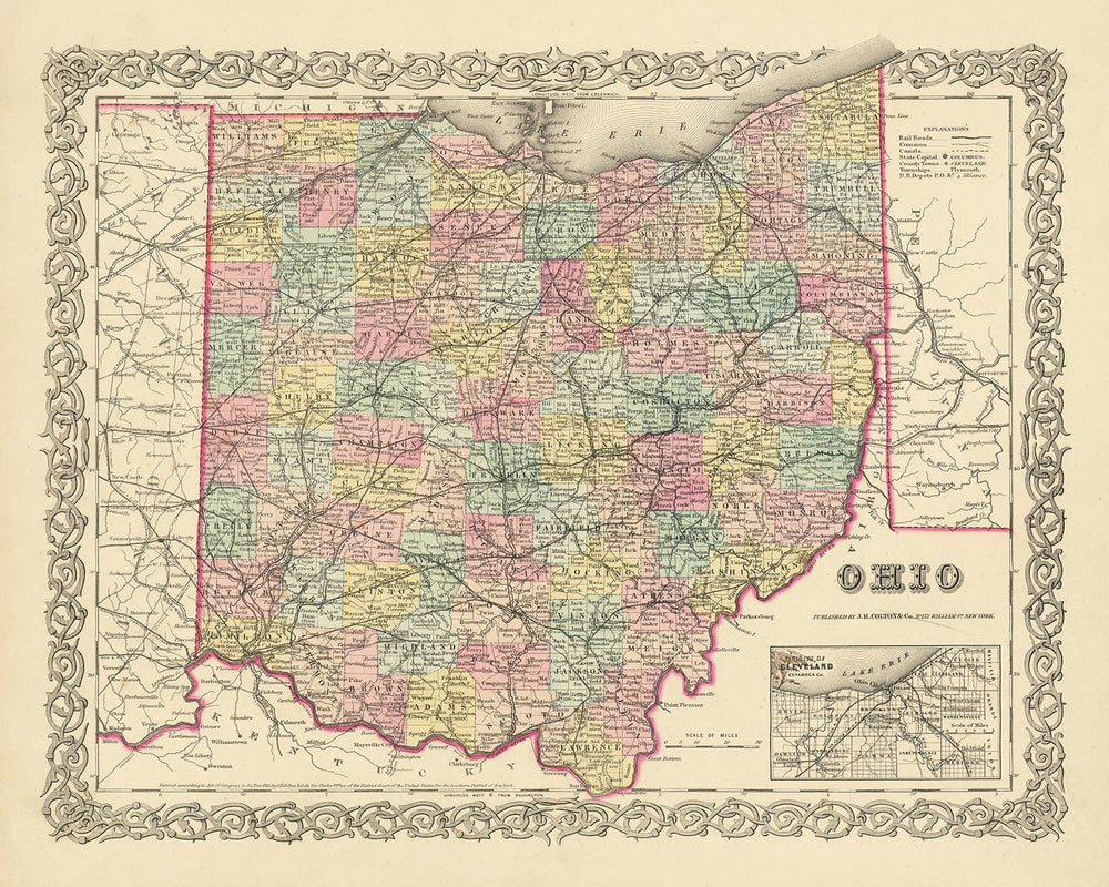
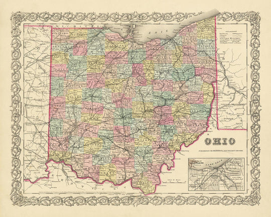


Old Map of Ohio by J. H. Colton, 1855: Cincinnati, Cleveland, Columbus, Dayton, and Toledo
20% off 2 — 33% off 3
Add any two eligible items to your bag to receive 20% off. Add a third and it will be complimentary (equivalent to 33% off when purchasing three).
No code needed — the offer applies automatically at checkout.
Valid on all standard maps and fine art prints. You can mix and match any designs.
If you’d like to ship items to multiple addresses, please contact us before placing your order.
Custom and bespoke commissions are excluded.
Contact us if you have any questions
-
![]() Handmade in the USA
Handmade in the USA

-
FREE worldwide delivery in 2-3 days ⓘ
Free delivery in 2-3 days
Your map should be delivered in 2-3 working days with free delivery, worldwide.
We make maps by hand locally in 23 countries, including the USA
![]() . If you're buying a gift for someone in another country, we will make the map locally to them.
. If you're buying a gift for someone in another country, we will make the map locally to them.You will never pay import tax or customs duty.
Express delivery is available at checkout which can reduce the delivery time to 1-2 days.
Please note that personalised maps, and larger framed maps, can take longer to produce and deliver.
If you need your order to arrive by a certain date, contact me and we can discuss your options.
-
Complimentary gifting & design advice
ⓘ
Complimentary gifting & design advice
Available almost 24/7 on WhatsApp and email — we usually reply within minutes. We can help you:
- Choose a perfectly personalised gift
- Send a digital gift preview to the recipient
- Pick the ideal size for your wall
- Select the right finish and frame
Quick, friendly advice so you can order with confidence.
For last minute gifts, consider buying a digital gift card. We have over 5,000 maps and art prints to choose from.
-
90-day returns & 5-year guarantee
ⓘ
90-day returns & 5-year guarantee
Products can be returned within 90 days for a full refund, or exchange for another product.
We are also proud to offer a 5-year quality guarantee on our maps and art, covering defects in materials or workmanship under normal use.
For personalised and custom made items, we may offer you store credit or a non-expiring gift card, as we cannot resell personalised orders.
If you have any questions, get in touch. For more information, see our full returns & exchanges policy.

This is a museum-grade archival print from the original 1855 map — restored in our workshop and made to order on 220gsm archival matte paper or 400gsm artist's cotton canvas with pigment inks.
Professional framing & free personalisation available.
1. Choose a size
2. Frame & personalize your map
Make your map unique with framing, hand-drawn customisation, vintage ageing, pop art text, unique 3D styling and more.


Gift message & custom finish

If you want to add a gift message, or a finish (jigsaw, aluminium board, etc.) that is not available here, please request it in the "order note" when you check out.
Every order is custom made, so if you need the size adjusted slightly, or printed on an unusual material, just let us know. We've done thousands of custom orders over the years, so there's (almost) nothing we can't manage.
You can also contact us before you order, if you prefer!

- Handmade locally. No import duty or tax
- FREE worldwide delivery
- 90-day returns & 5-year product guarantee
- Questions? WhatsApp me any time
Own a piece of history
7,000+ 5 star reviews


Delve into the past with this exquisitely detailed old map of Ohio, crafted by the esteemed mapmaker J. H. Colton in 1855. Colton, widely regarded as the finest American mapmaker of his era, has captured the essence of Ohio's early history in this meticulously designed map. The map showcases the state as it was in the mid-19th century, a time when the United States was in its infancy and many of the settlements we know today were yet to be founded.
This map hails from a time when Ohio was a burgeoning region, with settlements and towns beginning to take shape. It features the five most notable settlements of the time: Cincinnati, Cleveland, Columbus, Dayton, and Toledo. Each of these settlements has its own unique history, and this map serves as a testament to their beginnings and early development. It's a fascinating look into the past, providing insight into the evolution of these settlements over the last 150 years.
It's important to note that this map reflects a snapshot of Ohio's history during a time of rapid change and growth. Many of the names and borders that were present in 1855 have likely changed over the years, offering a fascinating contrast to the Ohio we know today. This map is not just a piece of history, but a conversation starter, inviting viewers to explore the transformations that have taken place over the past century and a half.
The craftsmanship of J. H. Colton is evident in every detail of this map. His reputation for precision and accuracy is well-deserved, and this map is a prime example of his skill and dedication. It's a unique opportunity to own a piece of history, beautifully rendered by one of the most respected mapmakers of the 19th century.
Whether you're a history enthusiast, a lover of maps, or simply someone who appreciates fine craftsmanship, this old map of Ohio by J. H. Colton is a treasure to behold. It offers a window into the past, inviting you to journey back to a time when Ohio was a new frontier, ripe with potential and promise. This map is more than just a historical artifact - it's a testament to the enduring spirit of exploration and discovery that continues to shape our world today.
Notable Settlements in Ohio, 1855
- Cincinnati (1788): Known as the "Queen City," Cincinnati was a major destination for German and Irish immigrants during the 19th century.
- Cleveland (1796): Originally called "Cleaveland," it became a significant manufacturing center due to its location on the Lake Erie and the Ohio and Erie Canal.
- Columbus (1812): The state capital and the most populous city in Ohio, Columbus was named after Christopher Columbus.
- Dayton (1796): Birthplace of the famous Wright brothers, Dayton played a crucial role in the invention of powered flight.
- Toledo (1833): Known for its industry, particularly in glass and auto assembly, Toledo is located on the western end of Lake Erie.
- Chillicothe (1796): Ohio's first capital, Chillicothe was a major center of the ancient Hopewell culture.
- Zanesville (1797): Known as "Clay City" or "Pottery Capital of the World" for its pottery industry.
- Akron (1825): The "Rubber Capital of the World," Akron was a center for the rubber industry, particularly tire manufacturing.
- Youngstown (1796): Known for its steel production, Youngstown played a significant role in the Industrial Revolution.
- Canton (1805): Birthplace of the National Football League (NFL).
- Springfield (1801): Known as the "End of the Historic National Road."
- Lancaster (1800): Known for its numerous historic buildings and districts.
- Marietta (1788): The first permanent settlement of the new United States in the territory northwest of the Ohio River.
- Steubenville (1797): Known as the "City of Murals," it was a gateway to the west via the Ohio River.
- Warren (1798): Known for its historic homes and connection to the Packard brothers, founders of the Packard Electric Company and the Packard Motor Car.
- Lima (1831): Known for its oil industry following the discovery of oil in Lima in 1885.
- Mansfield (1808): Known as "The Fun Center of Ohio," it is home to the historic Ohio State Reformatory.
- Elyria (1817): Known for its parks system and the invention of the padded bicycle seat.
- Sandusky (1818): Known for its waterfront location and Cedar Point amusement park.
- Middletown (1802): Known for its steel industry, particularly Armco Steel, and its contribution to World War II and Vietnam War efforts.
Native American Tribes
- Shawnee: Primarily located in the southern part of Ohio, the Shawnee were known for their warrior culture.
- Miami: Occupied the western part of Ohio, they were known for their intricate tattoo art.
- Wyandot: Inhabited the northern part of Ohio, the Wyandot were known for their agricultural practices.
- Delaware: Also known as the Lenape, they were pushed west into Ohio by European expansion.
Notable Natural Features
- Ohio River: Forms the southern boundary of Ohio and was a major transportation route.
- Lake Erie: The northern boundary of Ohio, it's the fourth largest of the five Great Lakes.
- Hocking Hills State Park: Known for its impressive sandstone formations.
- Cuyahoga Valley National Park: Known for its beautiful waterfalls and the historic Ohio & Erie Canal.
Historical Events (1810-1855)
- War of 1812 (1812-1815): Several battles took place in Ohio, including the pivotal Battle of Lake Erie.
- Ohio-Erie Canal Completion (1832): This major infrastructure project connected the Ohio River to Lake Erie, spurring economic growth.
- The Toledo War (1835-1836): A boundary dispute between Ohio and the Michigan Territory, which was resolved with Toledo remaining in Ohio.
Please double check the images to make sure that a specific town or place is shown on this map. You can also get in touch and ask us to check the map for you.
This map looks great at all sizes: 12x16in (30.5x41cm), 16x20in (40.5x51cm), 18x24in (45.5x61cm), 24x30in (61x76cm), 32x40in (81.5x102cm), 40x50in (102x127cm), 48x60in (122x153cm) and 56x70in (142x178cm), but it looks even better when printed large.
I can create beautiful, large prints of this map up to 70in (178cm). Please get in touch if you're looking for larger, customised or different framing options.
The model in the listing images is holding the 16x20in (40.5x51cm) version of this map.
The fifth listing image shows an example of my map personalisation service.
If you’re looking for something slightly different, check out my main collection of USA and North America maps.
Please contact me to check if a certain location, landmark or feature is shown on this map.
This would make a wonderful birthday, Christmas, Father's Day, work leaving, anniversary or housewarming gift for someone from the areas covered by this map.
This map is available as a giclée print on acid free archival matte paper, or you can buy it framed. The frame is a nice, simple black frame that suits most aesthetics. Please get in touch if you'd like a different frame colour or material. My frames are glazed with super-clear museum-grade acrylic (perspex/acrylite), which is significantly less reflective than glass, safer, and will always arrive in perfect condition.
This map is also available as a float framed canvas, sometimes known as a shadow gap framed canvas or canvas floater. The map is printed on artist's cotton canvas and then stretched over a handmade box frame. We then "float" the canvas inside a wooden frame, which is available in a range of colours (black, dark brown, oak, antique gold and white). This is a wonderful way to present a map without glazing in front. See some examples of float framed canvas maps and explore the differences between my different finishes.
For something truly unique, this map is also available in "Unique 3D", our trademarked process that dramatically transforms the map so that it has a wonderful sense of depth. We combine the original map with detailed topography and elevation data, so that mountains and the terrain really "pop". For more info and examples of 3D maps, check my Unique 3D page.
For most orders, delivery time is about 3 working days. Personalised and customised products take longer, as I have to do the personalisation and send it to you for approval, which usually takes 1 or 2 days.
Please note that very large framed orders usually take longer to make and deliver.
If you need your order to arrive by a certain date, please contact me before you order so that we can find the best way of making sure you get your order in time.
I print and frame maps and artwork in 23 countries around the world. This means your order will be made locally, which cuts down on delivery time and ensures that it won't be damaged during delivery. You'll never pay customs or import duty, and we'll put less CO2 into the air.
All of my maps and art prints are well packaged and sent in a rugged tube if unframed, or surrounded by foam if framed.
I try to send out all orders within 1 or 2 days of receiving your order, though some products (like face masks, mugs and tote bags) can take longer to make.
If you select Express Delivery at checkout your order we will prioritise your order and send it out by 1-day courier (Fedex, DHL, UPS, Parcelforce).
Next Day delivery is also available in some countries (US, UK, Singapore, UAE) but please try to order early in the day so that we can get it sent out on time.
My standard frame is a gallery style black ash hardwood frame. It is simple and quite modern looking. My standard frame is around 20mm (0.8in) wide.
I use super-clear acrylic (perspex/acrylite) for the frame glass. It's lighter and safer than glass - and it looks better, as the reflectivity is lower.
Six standard frame colours are available for free (black, dark brown, dark grey, oak, white and antique gold). Custom framing and mounting/matting is available if you're looking for something else.
Most maps, art and illustrations are also available as a framed canvas. We use matte (not shiny) cotton canvas, stretch it over a sustainably sourced box wood frame, and then 'float' the piece within a wood frame. The end result is quite beautiful, and there's no glazing to get in the way.
All frames are provided "ready to hang", with either a string or brackets on the back. Very large frames will have heavy duty hanging plates and/or a mounting baton. If you have any questions, please get in touch.
See some examples of my framed maps and framed canvas maps.
Alternatively, I can also supply old maps and artwork on canvas, foam board, cotton rag and other materials.
If you want to frame your map or artwork yourself, please read my size guide first.
My maps are extremely high quality reproductions of original maps.
I source original, rare maps from libraries, auction houses and private collections around the world, restore them at my London workshop, and then use specialist giclée inks and printers to create beautiful maps that look even better than the original.
My maps are printed on acid-free archival matte (not glossy) paper that feels very high quality and almost like card. In technical terms the paper weight/thickness is 10mil/200gsm. It's perfect for framing.
I print with Epson ultrachrome giclée UV fade resistant pigment inks - some of the best inks you can find.
I can also make maps on canvas, cotton rag and other exotic materials.
Learn more about The Unique Maps Co.
Map personalisation
If you're looking for the perfect anniversary or housewarming gift, I can personalise your map to make it truly unique. For example, I can add a short message, or highlight an important location, or add your family's coat of arms.
The options are almost infinite. Please see my map personalisation page for some wonderful examples of what's possible.
To order a personalised map, select "personalise your map" before adding it to your basket.
Get in touch if you're looking for more complex customisations and personalisations.
Map ageing
I have been asked hundreds of times over the years by customers if they could buy a map that looks even older.
Well, now you can, by selecting Aged before you add a map to your basket.
All the product photos you see on this page show the map in its Original form. This is what the map looks like today.
If you select Aged, I will age your map by hand, using a special and unique process developed through years of studying old maps, talking to researchers to understand the chemistry of aging paper, and of course... lots of practice!
If you're unsure, stick to the Original colour of the map. If you want something a bit darker and older looking, go for Aged.
If you are not happy with your order for any reason, contact me and I'll get it fixed ASAP, free of charge. Please see my returns and refund policy for more information.
I am very confident you will like your restored map or art print. I have been doing this since 1984. I'm a 5-star Etsy seller. I have sold tens of thousands of maps and art prints and have over 5,000 real 5-star reviews. My work has been featured in interior design magazines, on the BBC, and on the walls of dozens of 5-star hotels.
I use a unique process to restore maps and artwork that is massively time consuming and labour intensive. Hunting down the original maps and illustrations can take months. I use state of the art and eye-wateringly expensive technology to scan and restore them. As a result, I guarantee my maps and art prints are a cut above the rest. I stand by my products and will always make sure you're 100% happy with what you receive.
Almost all of my maps and art prints look amazing at large sizes (200cm, 6.5ft+) and I can frame and deliver them to you as well, via special oversized courier. Contact me to discuss your specific needs.
Or try searching for something!


