


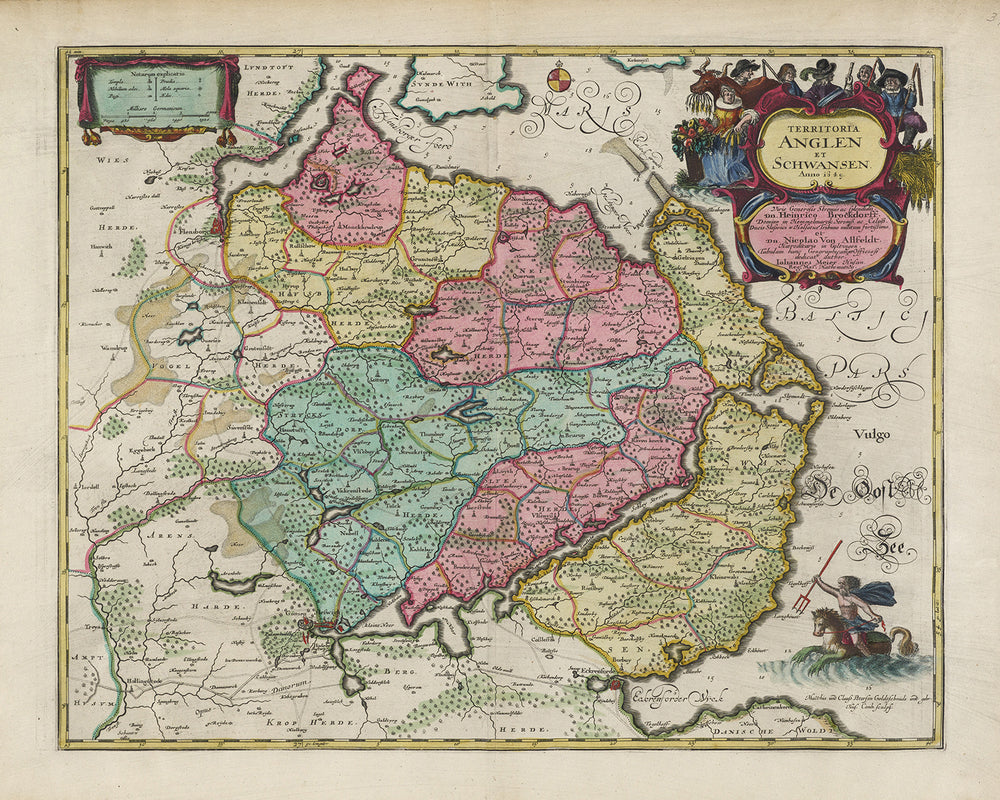
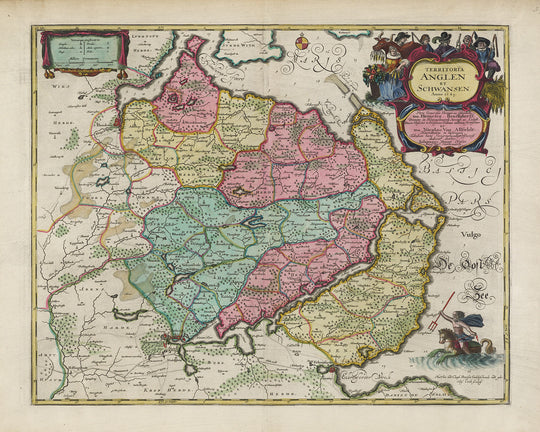


Old Map of Anglia and Schwansen by Joan Blaeu, 1665: Flensburg, Schleswig, Glücksburg, Kappeln, Süderbrarup, Baltic Sea, Fjords

-
![]() Handmade in the USA
Handmade in the USA
-
FREE worldwide delivery in 2-3 days ⓘ
Free delivery in 2-3 days
Your map should be delivered in 2-3 working days with free delivery, worldwide.
We make maps by hand locally in 23 countries, including the USA
![]() . If you're buying a gift for someone in another country, we will make the map locally to them.
. If you're buying a gift for someone in another country, we will make the map locally to them.You will never pay import tax or customs duty.
Express delivery is available at checkout which can reduce the delivery time to 1-2 days.
Please note that personalised maps, and larger framed maps, can take longer to produce and deliver.
If you need your order to arrive by a certain date, contact me and we can discuss your options.
-
90 day money back guarantee
ⓘ
90 days to return and refund
Products can be returned within 90 days for a full refund, or exchange for another product.
For personalised or custom made items, we may offer you store credit or a non-expiring gift card, as we cannot resell personalised orders.
If you have any questions, get in touch. For more information, see our full returns & exchanges policy.

My maps are rare, museum-grade, restored old maps sourced from libraries, auction houses and private collections across the globe.
Framing & free personalisation available
1. Select your size
2. Frame & personalize your map
Make your map unique with framing, hand-drawn customisation, vintage ageing, pop art text, unique 3D styling and moreGift message & custom finish

If you want to add a gift message, or a finish (jigsaw, aluminium board, etc.) that is not available here, please request it in the "order note" when you check out.
Every order is custom made, so if you need the size adjusted slightly, or printed on an unusual material, just let us know. We've done thousands of custom orders over the years, so there's (almost) nothing we can't manage.
You can also contact us before you order, if you prefer!

- Handmade locally. No import duty or tax
- FREE Delivery. Arrives in 2-3 days
- Love it or your money back
- Questions? WhatsApp me any time
Own a piece of history
5,000+ 5 star reviews


Experience the rich historical tapestry of the Anglia and Schwansen region through the Old Map of Territoria Anglen Et Schwansen by esteemed cartographer, Joan Blaeu, crafted in the year 1665. This exquisite artifact captures the essence of the region during the vibrant 17th century, with the charming German town of Mohrkirch gracing its center. Immerse yourself in the subtle details and let this magnificent piece transport you back in time. Unearth a plethora of enchanting towns, cities, and settlements, each with its unique historical significance.
Blaeu's mastery in cartography is evident in the way he meticulously charted the boundaries, rivers, lakes, and other natural phenomena, several of which have grown into modern-day tourist attractions. This map serves as not just a visual treat, but a gateway into the historical events of the 17th century that shaped this region. Each stroke, each name scripted onto the parchment, holds stories of times past, making this piece a truly valuable addition to your collection.
Settlements:
- Flensburg (Flensborg) - Founded in the 13th century, Flensburg is notable for its scenic harbor and charming old town featuring historic merchant houses.
- Schleswig (Slesvig) - Known for the Schleswig Cathedral and Gottorf Castle, it has been a significant settlement since Viking times.
- Glücksburg - Home to the renowned Glücksburg Castle, one of the most significant Renaissance castles in Northern Europe.
- Kappeln - A charming town known for its preserved 19th century mill, the Dutch windmill Amanda, and its unique herring fence.
- Süderbrarup - This town is notable for its traditional annual market, the Süderbrarup Fair, which has roots dating back to the 16th century.
- Satrup - Home to the Satrup medieval stage, an open-air theatre that stages historical plays.
- Tolk - Known for the Tolk-Schau family leisure and nature park, one of the oldest in Germany.
- Gelting - Home to the Gelting Wind Park, one of the first onshore wind farms in Germany.
- Husby - Renowned for the Husby Church, a Romanesque architecture marvel dating back to the 12th century.
- Sörup - The town is notable for its pristine Sörup Lake, a popular spot for fishing and bird watching.
- Langballig - Known for Langballigau harbor on the Flensburg Fjord, a popular tourist destination.
- Boren - Home to the historical monument of Boren-Lindaunis railway bridge, part of the disused Kiel–Flensburg railway.
- Rabenkirchen-Faulück - This village is home to the distinctive St. James' Church with a Romanesque granite cross.
- Mittelangeln - Known for its scenic rural landscapes and well-preserved medieval structures.
- Mohrkirch (Morkeer) - The central focus of the map, knownfor its church, St. John's, which has a baptismal font from around 1200.
- Unewatt - Known for the Landschaftsmuseum Unewatt, an open-air museum presenting the regional history and culture.
- Fahrdorf - Located on the Schlei fjord, known for its beautiful beach and the large Viking settlement of Hedeby nearby.
- Gelting - The home to the Gothic-style St. Catherine's Church, it's the central parish for the fishing communities in Gelting Bay.
- Großsolt - Known for its medieval brick church dedicated to St. Peter and Paul, dating back to 1509.
- Böklund - A hub for Bronze Age artifacts, with historical significance dating back to 1500 BC.
- Rügge - Known for its early 18th century half-timbered church and scenic landscapes.
- Sterup - The village's landmark is the St. Mary's Church, a red brick Romanesque edifice.
- Quern - Home to the historic Quern stone, an archaeological site dating back to the Stone Age.
- Freienwill - Known for its beautiful rural setting and its late medieval St. Lawrence's Church.
- Niesgrau - The settlement is known for its archaeological sites from the Stone and Bronze Ages.
- Janneby - Home to the Gothic-style St. John's Church, which dates back to the 13th century.
- Westerholz - Known for its location on the Flensburg Fjord, offering scenic beachside views.
- Ulsnis - This village is noted for its late-Gothic Ulsnis Church and charming Schlei landscapes.
- Brodersby - Known for the Brodersby Burial Ground, an archaeological site dating back to the Bronze Age.
- Ausacker - Home to the 13th-century fieldstone Ausacker Church, a landmark of the village.
- Ringsberg - Known for its panoramic views of the surrounding countryside and the city of Flensburg.
Notable Features:
- Schlei Fjord - This 42 km long inlet of the Baltic Sea shapes the picturesque landscape of Schwansen.
- Flensburg Fjord - The scenic fjord serves as the border between Germany and Denmark.
- Baltic Sea coastline - The stunning coastline offers beautiful beaches and bays, like Gelting Bay.
- Angeln Peninsula - The historical home of the Angles, who migrated to Britain in the Early Middle Ages.
- Langsee Lake - Near Schleswig, this lake is a popular tourist attraction, perfect for boating and birdwatching.
Historical Events:
- Thirty Years' War (1618-1648) - This region was deeply affected by the upheavals of this pan-European conflict.
- Second Northern War (1655-1660) - The towns and settlements faced raids and occupation during this conflict between Sweden and its adversaries.
Please double check the images to make sure that a specific town or place is shown on this map. You can also get in touch and ask us to check the map for you.
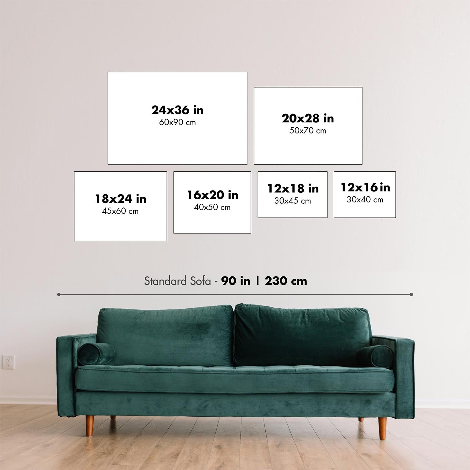
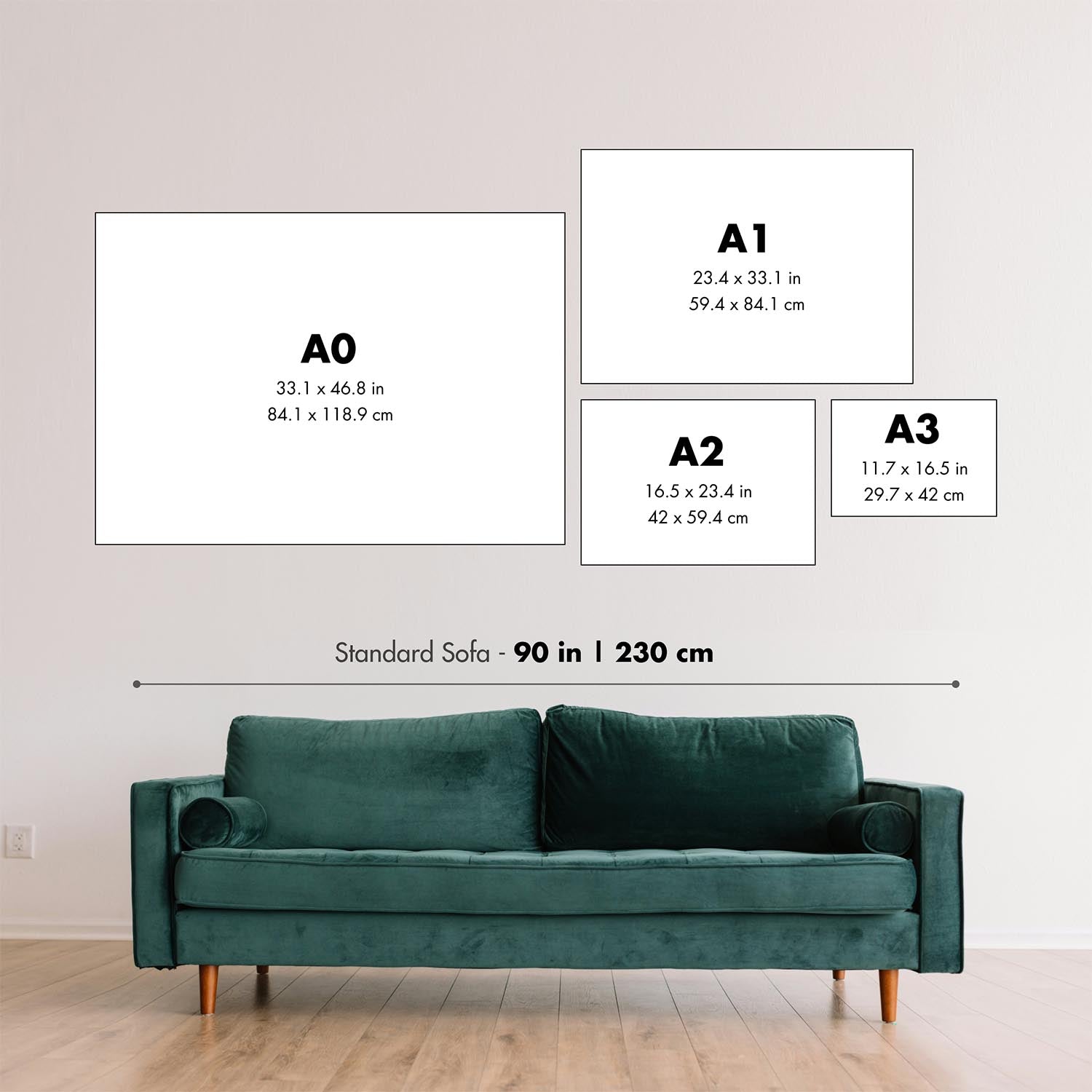
This map looks great at all sizes: 12x16in (30.5x41cm), 16x20in (40.5x51cm), 18x24in (45.5x61cm), 24x30in (61x76cm), 32x40in (81.5x102cm), 40x50in (102x127cm), 48x60in (122x153cm) and 56x70in (142x178cm), but it looks even better when printed large.
I can create beautiful, large prints of this map up to 70in (178cm). Please get in touch if you're looking for larger, customised or different framing options.
The model in the listing images is holding the 16x20in (40.5x51cm) version of this map.
The fifth listing image shows an example of my map personalisation service.
If you’re looking for something slightly different, check out my main collection of European city, province and country maps.
Please contact me to check if a certain location, landmark or feature is shown on this map.
This would make a wonderful birthday, Christmas, Father's Day, work leaving, anniversary or housewarming gift for someone from the areas covered by this map.
This map is available as a giclée print on acid free archival matte paper, or you can buy it framed. The frame is a nice, simple black frame that suits most aesthetics. Please get in touch if you'd like a different frame colour or material. My frames are glazed with super-clear museum-grade acrylic (perspex/acrylite), which is significantly less reflective than glass, safer, and will always arrive in perfect condition.
This map is also available as a float framed canvas, sometimes known as a shadow gap framed canvas or canvas floater. The map is printed on artist's cotton canvas and then stretched over a handmade box frame. We then "float" the canvas inside a wooden frame, which is available in a range of colours (black, dark brown, oak, antique gold and white). This is a wonderful way to present a map without glazing in front. See some examples of float framed canvas maps and explore the differences between my different finishes.
For something truly unique, this map is also available in "Unique 3D", our trademarked process that dramatically transforms the map so that it has a wonderful sense of depth. We combine the original map with detailed topography and elevation data, so that mountains and the terrain really "pop". For more info and examples of 3D maps, check my Unique 3D page.
For most orders, delivery time is about 3 working days. Personalised and customised products take longer, as I have to do the personalisation and send it to you for approval, which usually takes 1 or 2 days.
Please note that very large framed orders usually take longer to make and deliver.
If you need your order to arrive by a certain date, please contact me before you order so that we can find the best way of making sure you get your order in time.
I print and frame maps and artwork in 23 countries around the world. This means your order will be made locally, which cuts down on delivery time and ensures that it won't be damaged during delivery. You'll never pay customs or import duty, and we'll put less CO2 into the air.
All of my maps and art prints are well packaged and sent in a rugged tube if unframed, or surrounded by foam if framed.
I try to send out all orders within 1 or 2 days of receiving your order, though some products (like face masks, mugs and tote bags) can take longer to make.
If you select Express Delivery at checkout your order we will prioritise your order and send it out by 1-day courier (Fedex, DHL, UPS, Parcelforce).
Next Day delivery is also available in some countries (US, UK, Singapore, UAE) but please try to order early in the day so that we can get it sent out on time.
My standard frame is a gallery style black ash hardwood frame. It is simple and quite modern looking. My standard frame is around 20mm (0.8in) wide.
I use super-clear acrylic (perspex/acrylite) for the frame glass. It's lighter and safer than glass - and it looks better, as the reflectivity is lower.
Six standard frame colours are available for free (black, dark brown, dark grey, oak, white and antique gold). Custom framing and mounting/matting is available if you're looking for something else.
Most maps, art and illustrations are also available as a framed canvas. We use matte (not shiny) cotton canvas, stretch it over a sustainably sourced box wood frame, and then 'float' the piece within a wood frame. The end result is quite beautiful, and there's no glazing to get in the way.
All frames are provided "ready to hang", with either a string or brackets on the back. Very large frames will have heavy duty hanging plates and/or a mounting baton. If you have any questions, please get in touch.
See some examples of my framed maps and framed canvas maps.
Alternatively, I can also supply old maps and artwork on canvas, foam board, cotton rag and other materials.
If you want to frame your map or artwork yourself, please read my size guide first.
My maps are extremely high quality reproductions of original maps.
I source original, rare maps from libraries, auction houses and private collections around the world, restore them at my London workshop, and then use specialist giclée inks and printers to create beautiful maps that look even better than the original.
My maps are printed on acid-free archival matte (not glossy) paper that feels very high quality and almost like card. In technical terms the paper weight/thickness is 10mil/200gsm. It's perfect for framing.
I print with Epson ultrachrome giclée UV fade resistant pigment inks - some of the best inks you can find.
I can also make maps on canvas, cotton rag and other exotic materials.
Learn more about The Unique Maps Co.
Map personalisation
If you're looking for the perfect anniversary or housewarming gift, I can personalise your map to make it truly unique. For example, I can add a short message, or highlight an important location, or add your family's coat of arms.
The options are almost infinite. Please see my map personalisation page for some wonderful examples of what's possible.
To order a personalised map, select "personalise your map" before adding it to your basket.
Get in touch if you're looking for more complex customisations and personalisations.
Map ageing
I have been asked hundreds of times over the years by customers if they could buy a map that looks even older.
Well, now you can, by selecting Aged before you add a map to your basket.
All the product photos you see on this page show the map in its Original form. This is what the map looks like today.
If you select Aged, I will age your map by hand, using a special and unique process developed through years of studying old maps, talking to researchers to understand the chemistry of aging paper, and of course... lots of practice!
If you're unsure, stick to the Original colour of the map. If you want something a bit darker and older looking, go for Aged.
If you are not happy with your order for any reason, contact me for a no-quibble refund. Please see our returns and refund policy for more information.
I am very confident you will like your restored map or art print. I have been doing this since 1984. I'm a 5-star Etsy seller. I have sold tens of thousands of maps and art prints and have over 5,000 real 5-star reviews.
I use a unique process to restore maps and artwork that is massively time consuming and labour intensive. Hunting down the original maps and illustrations can take months. I use state of the art and eye-wateringly expensive technology to scan and restore them. As a result, I guarantee my maps and art prints are a cut above the rest - that's why I can offer a no-quibble refund.
Almost all of my maps and art prints look amazing at large sizes (200cm, 6.5ft+) and I can frame and deliver them to you as well, via special oversized courier. Contact me to discuss your specific needs.
Or try searching for something!


