


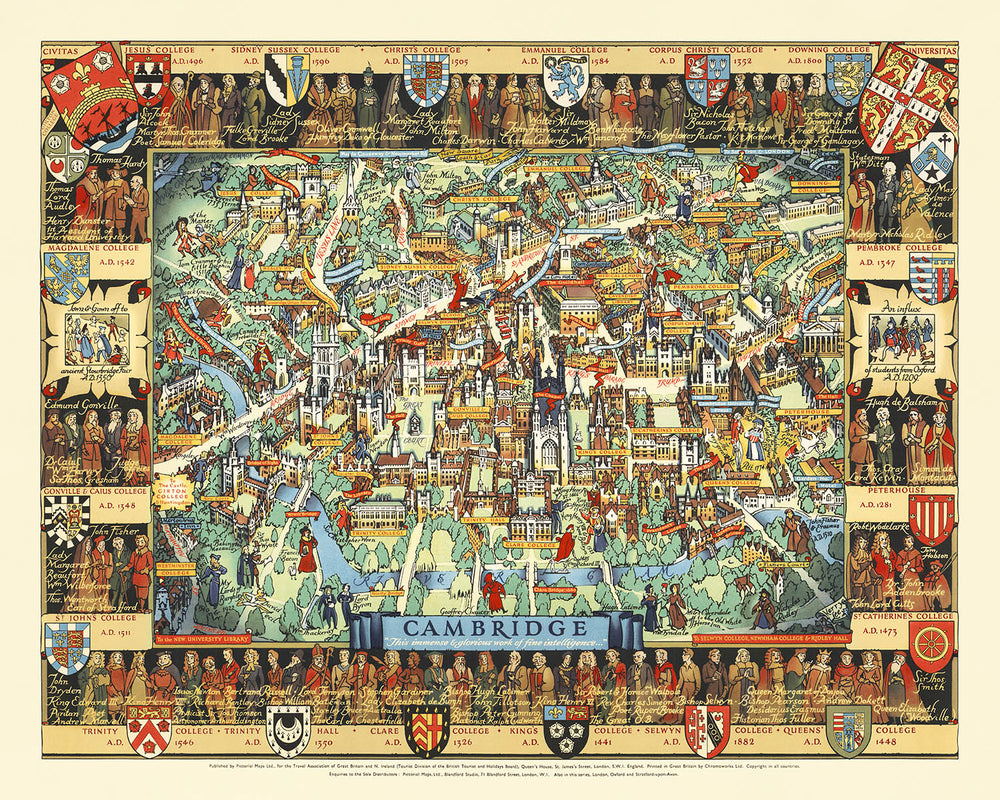


Old Pictorial Map of Cambridge by Lee, 1948: King's College, River Cam, Bridge of Sighs, Trinity College, St. John's
Buy 2, Get 1 Free
If you add 2 items to your bag, you can add a third product for free. The discount is automatic - no code required.
This is equivalent to 33% off, which will be the largest discount available on my shop this year.
This works for all maps and artwork. You can order 3 of the same thing, or 3 different things.
My custom maps are excluded, as they're too time consuming to make and we'd prefer to take our time rather than rush through a lot of orders.
Please take advantage of the deal and buy lots of beautiful maps and art for your walls.
Contact me if you have any questions.

-
![]() Handmade in the USA
Handmade in the USA
-
FREE worldwide delivery in 2-3 days ⓘ
Free delivery in 2-3 days
Your map should be delivered in 2-3 working days with free delivery, worldwide.
Deliveries over the Christmas and New Year period may be slightly delayed, as couriers and postal services catch up with a huge backlog of packages.
We make maps by hand locally in 23 countries, including the USA
![]() . If you're buying a gift for someone in another country, we will make the map locally to them.
. If you're buying a gift for someone in another country, we will make the map locally to them.You will never pay import tax or customs duty.
Express delivery is available at checkout which can reduce the delivery time to 1-2 days.
Please note that personalised maps, and larger framed maps, can take longer to produce and deliver.
If you need your order to arrive by a certain date, contact me and we can discuss your options.
-
FREE gift preview
ⓘ
Digital gift preview
After you complete your order, you can send a beautiful digital preview to the gift recipient. Just provide their email address and we'll do the rest. (Their email address will not be stored or used for any other purpose.)
This is perfect if you're concerned that your order might not arrive in time.
You can also buy a real non-expiring gift card, and email it directly to the recipient, so they can buy their own map or artwork.
-
90 day money back guarantee
ⓘ
90 days to return and refund
Products can be returned within 90 days for a full refund, or exchange for another product.
For personalised and custom made items, we may offer you store credit or a non-expiring gift card, as we cannot resell personalised orders.
If you have any questions, get in touch. For more information, see our full returns & exchanges policy.

My maps are rare, museum-grade, restored old maps sourced from libraries, auction houses and private collections across the globe.
Framing & free personalisation available
1. Select your size
Click here to order a custom size.
2. Frame & personalize your map
Make your map unique with framing, hand-drawn customisation, vintage ageing, pop art text, unique 3D styling and more.


Gift message & custom finish

If you want to add a gift message, or a finish (jigsaw, aluminium board, etc.) that is not available here, please request it in the "order note" when you check out.
Every order is custom made, so if you need the size adjusted slightly, or printed on an unusual material, just let us know. We've done thousands of custom orders over the years, so there's (almost) nothing we can't manage.
You can also contact us before you order, if you prefer!

- Handmade locally. No import duty or tax
- FREE worldwide delivery
- Love it or your money back (90 days)
- Questions? WhatsApp me any time
Own a piece of history
5,000+ 5 star reviews


Step into the rich history of one of England's most iconic cities with Kerry Lee's 1948 masterpiece, Cambridge, England. This captivating pictorial map is a celebration of Cambridge's cultural and educational legacy, meticulously illustrated to highlight the city's historic charm and architectural grandeur. At its heart, the map showcases the world-renowned University of Cambridge, with its storied colleges such as King's College, Trinity College, and St. John's College rendered in exquisite detail. The River Cam meanders gracefully through the city, connecting its landmarks and evoking the timeless beauty of this academic haven.
There is an Oxford map in the same style by the same mapmaker.
Kerry Lee, the celebrated British artist behind this work, was known for his intricate and decorative cartographic style. His maps are not just guides but artistic tributes, blending historical reverence with visual storytelling. In this map, Lee masterfully integrates heraldic shields, decorative borders, and depictions of historical figures, creating a piece that is as much about the spirit of Cambridge as it is about its geography. His work for the Travel Association of Great Britain and Northern Ireland reflects a post-war era's pride in national heritage and its invitation to explore the cultural treasures of England.
The map’s thematic richness extends beyond its academic focus, capturing the vibrant neighborhoods and landmarks that define Cambridge. The iconic Bridge of Sighs, King's College Chapel, and the lush green spaces along the River Cam are all prominently featured, offering a glimpse into the city's unique blend of history and natural beauty. Each detail tells a story, from the heraldic crests of the colleges to the bustling streets like King's Parade and Trumpington Street, which have witnessed centuries of intellectual and cultural exchange.
What sets this map apart is its ability to immerse viewers in the historical and architectural tapestry of Cambridge. The decorative borders frame the city’s legacy, featuring notable scholars, founding dates of colleges, and artistic flourishes that pay homage to the city’s intellectual heritage. This is not merely a map but a visual narrative, a celebration of Cambridge as a cradle of knowledge and a symbol of England’s enduring cultural significance.
For collectors and enthusiasts of historical cartography, Cambridge, England is a rare gem that combines artistry, history, and geography. It offers a window into the city’s storied past, making it a perfect addition to any collection that values both aesthetic beauty and historical depth. This map is more than a guide; it is a tribute to one of the world’s most remarkable cities, captured through the eyes of a master mapmaker.
Streets and roads on this map
- Bridge Street
- Chesterton Lane
- Downing Street
- Emmanuel Road
- Fen Causeway
- Free School Lane
- Jesus Lane
- King's Parade
- Magdalene Street
- Mill Lane
- Newnham Road
- Pembroke Street
- Regent Street
- St. Andrew's Street
- Silver Street
- Sidney Street
- Trumpington Street
- Victoria Avenue
- West Road
- Wheeler Street
Notable Features & Landmarks
- Illustrations:
- Detailed depictions of Cambridge's iconic colleges, including King's College, Trinity College, and St. John's College.
- Artistic renderings of historical figures and scholars associated with Cambridge.
- Heraldic shields representing various colleges and institutions.
- Landmarks:
- The River Cam winding through the city.
- The Bridge of Sighs and King's College Chapel, prominently featured.
- Other notable features:
- Decorative borders with historical figures, coats of arms, and college founding dates.
- A central banner reading "Cambridge," celebrating the city's significance.
Historical and design context
- Historical significance:
- Created in 1948, this map reflects the post-World War II era's focus on heritage and tourism.
- Celebrates Cambridge as a center of education, culture, and intellectual history.
- Design and style:
- Pictorial and thematic, with vibrant illustrations and intricate details.
- Incorporates heraldry, historical figures, and architectural landmarks.
- Designed by Kerry Lee, a renowned British artist known for his decorative cartographic works.
- Themes and topics:
- Highlights Cambridge's cultural and educational legacy, with a focus on its world-famous university and colleges.
- Serves as both a guide and a historical tribute to one of England's most iconic cities.
Please double check the images to make sure that a specific town or place is shown on this map. You can also get in touch and ask us to check the map for you.
This map looks great at every size, but I always recommend going for a larger size if you have space. That way you can easily make out all of the details.
This map looks amazing at sizes all the way up to 90in (230cm). If you are looking for a larger map, please get in touch.
The model in the listing images is holding the 16x20in (40x50cm) version of this map.
The fifth listing image shows an example of my map personalisation service.
If you’re looking for something slightly different, check out my collection of the best old maps to see if something else catches your eye.
Please contact me to check if a certain location, landmark or feature is shown on this map.
This would make a wonderful birthday, Christmas, Father's Day, work leaving, anniversary or housewarming gift for someone from the areas covered by this map.
This map is available as a giclée print on acid free archival matte paper, or you can buy it framed. The frame is a nice, simple black frame that suits most aesthetics. Please get in touch if you'd like a different frame colour or material. My frames are glazed with super-clear museum-grade acrylic (perspex/acrylite), which is significantly less reflective than glass, safer, and will always arrive in perfect condition.
This map is also available as a float framed canvas, sometimes known as a shadow gap framed canvas or canvas floater. The map is printed on artist's cotton canvas and then stretched over a handmade box frame. We then "float" the canvas inside a wooden frame, which is available in a range of colours (black, dark brown, oak, antique gold and white). This is a wonderful way to present a map without glazing in front. See some examples of float framed canvas maps and explore the differences between my different finishes.
For something truly unique, this map is also available in "Unique 3D", our trademarked process that dramatically transforms the map so that it has a wonderful sense of depth. We combine the original map with detailed topography and elevation data, so that mountains and the terrain really "pop". For more info and examples of 3D maps, check my Unique 3D page.
For most orders, delivery time is about 3 working days. Personalised and customised products take longer, as I have to do the personalisation and send it to you for approval, which usually takes 1 or 2 days.
Please note that very large framed orders usually take longer to make and deliver.
If you need your order to arrive by a certain date, please contact me before you order so that we can find the best way of making sure you get your order in time.
I print and frame maps and artwork in 23 countries around the world. This means your order will be made locally, which cuts down on delivery time and ensures that it won't be damaged during delivery. You'll never pay customs or import duty, and we'll put less CO2 into the air.
All of my maps and art prints are well packaged and sent in a rugged tube if unframed, or surrounded by foam if framed.
I try to send out all orders within 1 or 2 days of receiving your order, though some products (like face masks, mugs and tote bags) can take longer to make.
If you select Express Delivery at checkout your order we will prioritise your order and send it out by 1-day courier (Fedex, DHL, UPS, Parcelforce).
Next Day delivery is also available in some countries (US, UK, Singapore, UAE) but please try to order early in the day so that we can get it sent out on time.
My standard frame is a gallery style black ash hardwood frame. It is simple and quite modern looking. My standard frame is around 20mm (0.8in) wide.
I use super-clear acrylic (perspex/acrylite) for the frame glass. It's lighter and safer than glass - and it looks better, as the reflectivity is lower.
Six standard frame colours are available for free (black, dark brown, dark grey, oak, white and antique gold). Custom framing and mounting/matting is available if you're looking for something else.
Most maps, art and illustrations are also available as a framed canvas. We use matte (not shiny) cotton canvas, stretch it over a sustainably sourced box wood frame, and then 'float' the piece within a wood frame. The end result is quite beautiful, and there's no glazing to get in the way.
All frames are provided "ready to hang", with either a string or brackets on the back. Very large frames will have heavy duty hanging plates and/or a mounting baton. If you have any questions, please get in touch.
See some examples of my framed maps and framed canvas maps.
Alternatively, I can also supply old maps and artwork on canvas, foam board, cotton rag and other materials.
If you want to frame your map or artwork yourself, please read my size guide first.
My maps are extremely high quality reproductions of original maps.
I source original, rare maps from libraries, auction houses and private collections around the world, restore them at my London workshop, and then use specialist giclée inks and printers to create beautiful maps that look even better than the original.
My maps are printed on acid-free archival matte (not glossy) paper that feels very high quality and almost like card. In technical terms the paper weight/thickness is 10mil/200gsm. It's perfect for framing.
I print with Epson ultrachrome giclée UV fade resistant pigment inks - some of the best inks you can find.
I can also make maps on canvas, cotton rag and other exotic materials.
Learn more about The Unique Maps Co.
Map personalisation
If you're looking for the perfect anniversary or housewarming gift, I can personalise your map to make it truly unique. For example, I can add a short message, or highlight an important location, or add your family's coat of arms.
The options are almost infinite. Please see my map personalisation page for some wonderful examples of what's possible.
To order a personalised map, select "personalise your map" before adding it to your basket.
Get in touch if you're looking for more complex customisations and personalisations.
Map ageing
I have been asked hundreds of times over the years by customers if they could buy a map that looks even older.
Well, now you can, by selecting Aged before you add a map to your basket.
All the product photos you see on this page show the map in its Original form. This is what the map looks like today.
If you select Aged, I will age your map by hand, using a special and unique process developed through years of studying old maps, talking to researchers to understand the chemistry of aging paper, and of course... lots of practice!
If you're unsure, stick to the Original colour of the map. If you want something a bit darker and older looking, go for Aged.
If you are not happy with your order for any reason, contact me and I'll get it fixed ASAP, free of charge. Please see my returns and refund policy for more information.
I am very confident you will like your restored map or art print. I have been doing this since 1984. I'm a 5-star Etsy seller. I have sold tens of thousands of maps and art prints and have over 5,000 real 5-star reviews. My work has been featured in interior design magazines, on the BBC, and on the walls of dozens of 5-star hotels.
I use a unique process to restore maps and artwork that is massively time consuming and labour intensive. Hunting down the original maps and illustrations can take months. I use state of the art and eye-wateringly expensive technology to scan and restore them. As a result, I guarantee my maps and art prints are a cut above the rest. I stand by my products and will always make sure you're 100% happy with what you receive.
Almost all of my maps and art prints look amazing at large sizes (200cm, 6.5ft+) and I can frame and deliver them to you as well, via special oversized courier. Contact me to discuss your specific needs.
Or try searching for something!


