


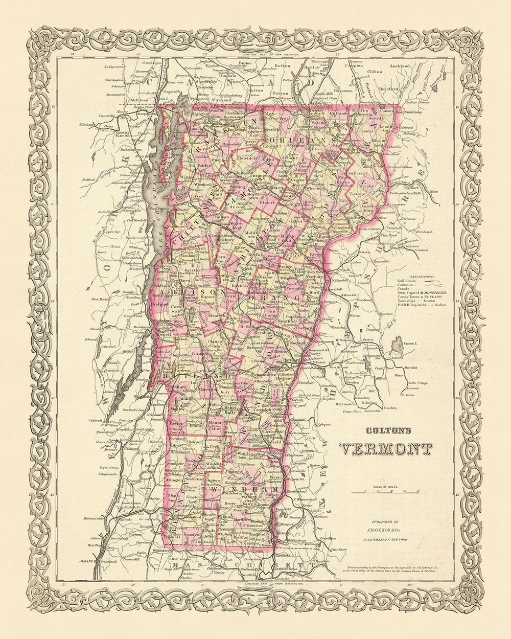
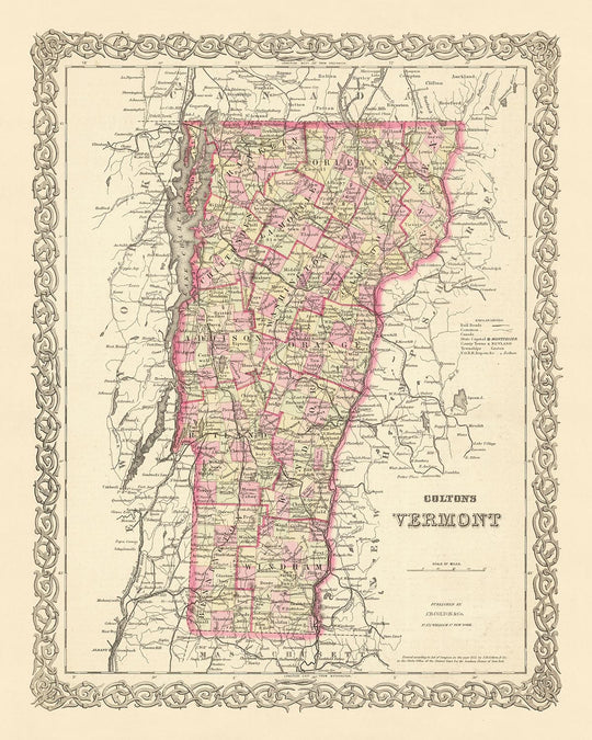


Old Map of Vermont by J.H. Colton, 1855: Burlington, Montpelier, Rutland, Brattleboro, St. Albans

-
![]() Handmade in the USA
Handmade in the USA
-
FREE worldwide delivery in 2-3 days ⓘ
Free delivery in 2-3 days
Your map should be delivered in 2-3 working days with free delivery, worldwide.
We make maps by hand locally in 23 countries, including the USA
![]() . If you're buying a gift for someone in another country, we will make the map locally to them.
. If you're buying a gift for someone in another country, we will make the map locally to them.You will never pay import tax or customs duty.
Express delivery is available at checkout which can reduce the delivery time to 1-2 days.
Please note that personalised maps, and larger framed maps, can take longer to produce and deliver.
If you need your order to arrive by a certain date, contact me and we can discuss your options.
-
90 day money back guarantee
ⓘ
90 days to return and refund
Products can be returned within 90 days for a full refund, or exchange for another product.
For personalised or custom made items, we may offer you store credit or a non-expiring gift card, as we cannot resell personalised orders.
If you have any questions, get in touch. For more information, see our full returns & exchanges policy.

My maps are rare, museum-grade, restored old maps sourced from libraries, auction houses and private collections across the globe.
Framing & free personalisation available
1. Select your size
2. Frame & personalize your map
Make your map unique with framing, hand-drawn customisation, vintage ageing, pop art text, unique 3D styling and moreGift message & custom finish

If you want to add a gift message, or a finish (jigsaw, aluminium board, etc.) that is not available here, please request it in the "order note" when you check out.
Every order is custom made, so if you need the size adjusted slightly, or printed on an unusual material, just let us know. We've done thousands of custom orders over the years, so there's (almost) nothing we can't manage.
You can also contact us before you order, if you prefer!

- Handmade locally. No import duty or tax
- FREE Delivery. Arrives in 2-3 days
- Love it or your money back
- Questions? WhatsApp me any time
Own a piece of history
5,000+ 5 star reviews


This exquisite piece of cartographic history is an old map of Vermont, created in 1855 by J.H. Colton, a renowned figure in the world of mapmaking. Known for his meticulous attention to detail and accuracy, Colton's work provides a unique window into the past, offering an unparalleled view of Vermont as it was in the mid-19th century.
In 1855, the United States was still in its infancy, and Vermont, one of the earliest states to join the Union, was still undergoing significant development. Many of the settlements that we are familiar with today had not yet been established, and the borders and names that are now taken for granted may have been markedly different. This map offers a fascinating glimpse into this transformative period in American history.
Among the notable settlements depicted on this map are Burlington, Montpelier, Rutland, Brattleboro, and St. Albans. These towns and cities, some of which are now major population centers, were in their early stages of growth in 1855. The map provides a unique perspective on their development, capturing a snapshot of their history that is now over 150 years old.
J.H. Colton's maps are celebrated for their precise detail and accuracy, and this map of Vermont is no exception. Colton's maps were among the most reliable and sought-after of their time, and this piece serves as a testament to his unparalleled skill and craftsmanship. It offers a rare opportunity to delve into the history of Vermont and the United States, providing a unique perspective that is both educational and aesthetically pleasing.
This map is not just a piece of history, but a work of art. The fine details, the carefully drawn borders, and the meticulous labeling all contribute to its charm. It is a treasure for anyone interested in cartography, history, or the development of the United States. Whether you're a collector, a historian, or simply someone who appreciates the beauty of old maps, this piece is sure to captivate and inspire.
In conclusion, this old map of Vermont by J.H. Colton, 1855, is a remarkable piece of history. It provides a snapshot of a time when the United States was still forming, when Vermont was still growing, and when towns like Burlington, Montpelier, Rutland, Brattleboro, and St. Albans were just beginning to make their mark. It's a testament to the skill and craftsmanship of one of the finest American mapmakers of the era, and a fascinating window into the past.
Notable Settlements in Vermont, 1855
- Burlington (1763): Known as the "Queen City," Burlington is the most populous city in Vermont. It was a bustling port and hub of activity during the 19th century.
- Montpelier (1787): The smallest state capital in the U.S., Montpelier became known for its granite industry in the 19th century.
- Rutland (1761): Rutland is notable for its marble industry, which began in the early 19th century.
- Brattleboro (1753): Known for its vibrant arts scene, Brattleboro was an important stop on the Underground Railroad.
- St. Albans (1763): Known as the "Railroad City," St. Albans was a key railway hub in the 19th century.
- Bennington (1749): Site of the Battle of Bennington during the Revolutionary War.
- Middlebury (1761): Home to Middlebury College, one of the oldest liberal arts colleges in the U.S.
- Woodstock (1761): Known for its picturesque village green and historic homes.
- Windsor (1761): Birthplace of Vermont and home to the Constitution House, where the state constitution was signed.
- Barre (1788): Known as the "Granite Center of the World," Barre was a major center for granite quarrying.
- Norwich (1761): Home to Norwich University, the oldest private military college in the U.S.
- Manchester (1761): Known for its marble sidewalks and historic architecture.
- St. Johnsbury (1786): Home to the Fairbanks Museum and Planetarium, Vermont's oldest natural history museum.
- Newport (1793): Known for its location on Lake Memphremagog, which straddles the U.S.-Canada border.
- Vergennes (1788): The smallest city and first incorporated city in Vermont.
- Bellows Falls (1753): Known for its historic canal system and vibrant arts scene.
- Shelburne (1763): Home to the Shelburne Museum, a collection of American folk art.
- Poultney (1761): Known for its slate industry and as the birthplace of Horace Greeley, founder of the New York Tribune.
- Swanton (1763): Home to the Missisquoi National Wildlife Refuge.
- Fair Haven (1779): Known for its slate and marble industry.
Native American Tribes in Vermont
- Abenaki Tribe: The Abenaki were the primary tribe in Vermont, known for their pottery and basket weaving skills.
- Iroquois Confederacy: While primarily located in New York, the Iroquois had influence in Vermont and often clashed with the Abenaki.
Notable Natural Features
- Lake Champlain: The largest lake in Vermont, known for its fishing and boating.
- Green Mountains: A major mountain range in Vermont, popular for hiking and skiing.
- Quechee Gorge: Known as "Vermont's Little Grand Canyon," it's a popular tourist attraction.
- Missisquoi River: A major river in Vermont, known for its wildlife and fishing.
Historical Events (1810-1855)
- War of 1812 (1812-1815): Vermont was a key frontier in the War of 1812, with several battles fought along the Lake Champlain corridor.
- Anti-Masonic Party (1828): Vermont was the birthplace of the Anti-Masonic Party, the first third party in the United States.
- Underground Railroad (1800s): Vermont was a key stop on the Underground Railroad, helping many slaves escape to freedom in Canada.
Please double check the images to make sure that a specific town or place is shown on this map. You can also get in touch and ask us to check the map for you.
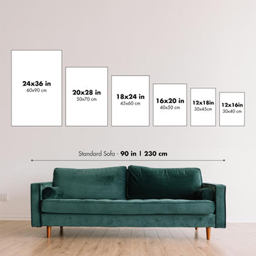
This map looks great at all sizes: 12x16in (30.5x41cm), 16x20in (40.5x51cm), 18x24in (45.5x61cm), 24x30in (61x76cm), 32x40in (81.5x102cm), 40x50in (102x127cm), 48x60in (122x153cm) and 56x70in (142x178cm), but it looks even better when printed large.
I can create beautiful, large prints of this map up to 70in (178cm). Please get in touch if you're looking for larger, customised or different framing options.
The model in the listing images is holding the 16x20in (40.5x51cm) version of this map.
The fifth listing image shows an example of my map personalisation service.
If you’re looking for something slightly different, check out my main collection of USA and North America maps.
Please contact me to check if a certain location, landmark or feature is shown on this map.
This would make a wonderful birthday, Christmas, Father's Day, work leaving, anniversary or housewarming gift for someone from the areas covered by this map.
This map is available as a giclée print on acid free archival matte paper, or you can buy it framed. The frame is a nice, simple black frame that suits most aesthetics. Please get in touch if you'd like a different frame colour or material. My frames are glazed with super-clear museum-grade acrylic (perspex/acrylite), which is significantly less reflective than glass, safer, and will always arrive in perfect condition.
This map is also available as a float framed canvas, sometimes known as a shadow gap framed canvas or canvas floater. The map is printed on artist's cotton canvas and then stretched over a handmade box frame. We then "float" the canvas inside a wooden frame, which is available in a range of colours (black, dark brown, oak, antique gold and white). This is a wonderful way to present a map without glazing in front. See some examples of float framed canvas maps and explore the differences between my different finishes.
For something truly unique, this map is also available in "Unique 3D", our trademarked process that dramatically transforms the map so that it has a wonderful sense of depth. We combine the original map with detailed topography and elevation data, so that mountains and the terrain really "pop". For more info and examples of 3D maps, check my Unique 3D page.
For most orders, delivery time is about 3 working days. Personalised and customised products take longer, as I have to do the personalisation and send it to you for approval, which usually takes 1 or 2 days.
Please note that very large framed orders usually take longer to make and deliver.
If you need your order to arrive by a certain date, please contact me before you order so that we can find the best way of making sure you get your order in time.
I print and frame maps and artwork in 23 countries around the world. This means your order will be made locally, which cuts down on delivery time and ensures that it won't be damaged during delivery. You'll never pay customs or import duty, and we'll put less CO2 into the air.
All of my maps and art prints are well packaged and sent in a rugged tube if unframed, or surrounded by foam if framed.
I try to send out all orders within 1 or 2 days of receiving your order, though some products (like face masks, mugs and tote bags) can take longer to make.
If you select Express Delivery at checkout your order we will prioritise your order and send it out by 1-day courier (Fedex, DHL, UPS, Parcelforce).
Next Day delivery is also available in some countries (US, UK, Singapore, UAE) but please try to order early in the day so that we can get it sent out on time.
My standard frame is a gallery style black ash hardwood frame. It is simple and quite modern looking. My standard frame is around 20mm (0.8in) wide.
I use super-clear acrylic (perspex/acrylite) for the frame glass. It's lighter and safer than glass - and it looks better, as the reflectivity is lower.
Six standard frame colours are available for free (black, dark brown, dark grey, oak, white and antique gold). Custom framing and mounting/matting is available if you're looking for something else.
Most maps, art and illustrations are also available as a framed canvas. We use matte (not shiny) cotton canvas, stretch it over a sustainably sourced box wood frame, and then 'float' the piece within a wood frame. The end result is quite beautiful, and there's no glazing to get in the way.
All frames are provided "ready to hang", with either a string or brackets on the back. Very large frames will have heavy duty hanging plates and/or a mounting baton. If you have any questions, please get in touch.
See some examples of my framed maps and framed canvas maps.
Alternatively, I can also supply old maps and artwork on canvas, foam board, cotton rag and other materials.
If you want to frame your map or artwork yourself, please read my size guide first.
My maps are extremely high quality reproductions of original maps.
I source original, rare maps from libraries, auction houses and private collections around the world, restore them at my London workshop, and then use specialist giclée inks and printers to create beautiful maps that look even better than the original.
My maps are printed on acid-free archival matte (not glossy) paper that feels very high quality and almost like card. In technical terms the paper weight/thickness is 10mil/200gsm. It's perfect for framing.
I print with Epson ultrachrome giclée UV fade resistant pigment inks - some of the best inks you can find.
I can also make maps on canvas, cotton rag and other exotic materials.
Learn more about The Unique Maps Co.
Map personalisation
If you're looking for the perfect anniversary or housewarming gift, I can personalise your map to make it truly unique. For example, I can add a short message, or highlight an important location, or add your family's coat of arms.
The options are almost infinite. Please see my map personalisation page for some wonderful examples of what's possible.
To order a personalised map, select "personalise your map" before adding it to your basket.
Get in touch if you're looking for more complex customisations and personalisations.
Map ageing
I have been asked hundreds of times over the years by customers if they could buy a map that looks even older.
Well, now you can, by selecting Aged before you add a map to your basket.
All the product photos you see on this page show the map in its Original form. This is what the map looks like today.
If you select Aged, I will age your map by hand, using a special and unique process developed through years of studying old maps, talking to researchers to understand the chemistry of aging paper, and of course... lots of practice!
If you're unsure, stick to the Original colour of the map. If you want something a bit darker and older looking, go for Aged.
If you are not happy with your order for any reason, contact me for a no-quibble refund. Please see our returns and refund policy for more information.
I am very confident you will like your restored map or art print. I have been doing this since 1984. I'm a 5-star Etsy seller. I have sold tens of thousands of maps and art prints and have over 5,000 real 5-star reviews.
I use a unique process to restore maps and artwork that is massively time consuming and labour intensive. Hunting down the original maps and illustrations can take months. I use state of the art and eye-wateringly expensive technology to scan and restore them. As a result, I guarantee my maps and art prints are a cut above the rest - that's why I can offer a no-quibble refund.
Almost all of my maps and art prints look amazing at large sizes (200cm, 6.5ft+) and I can frame and deliver them to you as well, via special oversized courier. Contact me to discuss your specific needs.
Or try searching for something!


