


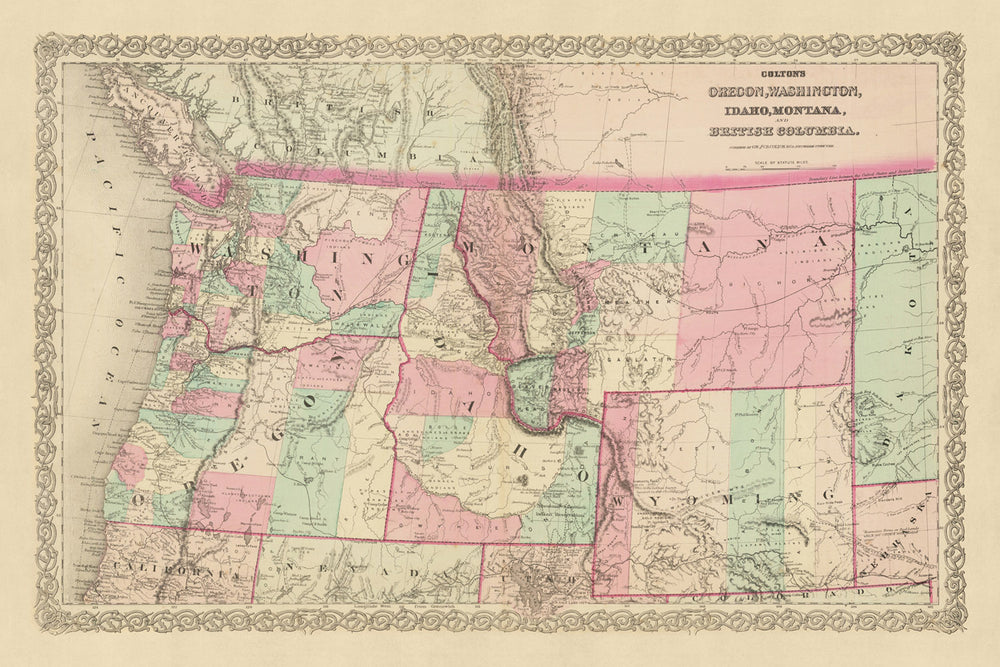


Old Map of the Pacific Northwest by J. H. Colton, 1868: Portland, Seattle, Boise, Helena, Cheyenne

-
![]() Handmade in the USA
Handmade in the USA
-
FREE worldwide delivery in 2-3 days ⓘ
Free delivery in 2-3 days
Your map should be delivered in 2-3 working days with free delivery, worldwide.
We make maps by hand locally in 23 countries, including the USA
![]() . If you're buying a gift for someone in another country, we will make the map locally to them.
. If you're buying a gift for someone in another country, we will make the map locally to them.You will never pay import tax or customs duty.
Express delivery is available at checkout which can reduce the delivery time to 1-2 days.
Please note that personalised maps, and larger framed maps, can take longer to produce and deliver.
If you need your order to arrive by a certain date, contact me and we can discuss your options.
-
90 day money back guarantee
ⓘ
90 days to return and refund
Products can be returned within 90 days for a full refund, or exchange for another product.
For personalised or custom made items, we may offer you store credit or a non-expiring gift card, as we cannot resell personalised orders.
If you have any questions, get in touch. For more information, see our full returns & exchanges policy.

My maps are rare, museum-grade, restored old maps sourced from libraries, auction houses and private collections across the globe.
Framing & free personalisation available
1. Select your size
2. Frame & personalize your map
Make your map unique with framing, hand-drawn customisation, vintage ageing, pop art text, unique 3D styling and moreGift message & custom finish

If you want to add a gift message, or a finish (jigsaw, aluminium board, etc.) that is not available here, please request it in the "order note" when you check out.
Every order is custom made, so if you need the size adjusted slightly, or printed on an unusual material, just let us know. We've done thousands of custom orders over the years, so there's (almost) nothing we can't manage.
You can also contact us before you order, if you prefer!

- Handmade locally. No import duty or tax
- FREE Delivery. Arrives in 2-3 days
- Love it or your money back
- Questions? WhatsApp me any time
Own a piece of history
5,000+ 5 star reviews


In the grand tapestry of the United States' historical narrative, the late 1860s occupy a unique and transformative position. This was a period when the frontier spirit was in full swing, yet vast swaths of the nation were still enigmatic terrains, often represented more by imagination than by knowledge. The Pacific Northwest, in particular, had just begun its journey into the national consciousness. In 1868, many of the cities, towns, and landmarks we now associate with Oregon, Washington, Idaho, Montana, and Wyoming were yet to be established. Nonetheless, the allure and promise of this region beckoned to pioneers, entrepreneurs, and adventurers.
This map, a meticulous work of the renowned J. H. Colton, offers an illuminating snapshot of the Pacific Northwest during this pivotal time. Colton, widely regarded as the finest American mapmaker of his era, has an unmatched ability to convey both geographical accuracy and the zeitgeist of the age. His depictions are not mere sketches but stories of a burgeoning nation, its landscape, and its ambition.
However, as with all things that stand as testament to history, this map provides insights into a world that has evolved considerably over the past century and a half. Borders have been redrawn, settlements renamed or absorbed into larger entities, and entire communities have sprouted in places that were once wilderness. It's a fascinating chronicle, highlighting the dynamism of human endeavor and the ever-shifting sands of time.
Towns, Cities, and Settlements by State
-
Oregon:
- Astoria (1811): Originally established as Fort Astoria, it was the first American-owned settlement on the Pacific coast and played a vital role in the fur trade.
- Salem (1842): Known initially as Chemeketa, Salem became Oregon's capital and is historically significant for its role in westward expansion.
- Oregon City (1829): Originally known as Willamette Falls, it was the endpoint of the Oregon Trail and the state's first capital.
- Jacksonville (1851): Established following a gold rush, it was an early commercial hub in southern Oregon.
- Portland (1845): Founded near the confluence of the Willamette and Columbia rivers, it became a major port in the Pacific Northwest.
-
Washington:
- Vancouver (1825): Originally Fort Vancouver, it was a significant fur trading post for the British Hudson's Bay Company.
- Olympia (1850): Became the capital of the Washington Territory and later the state capital.
- Steilacoom (1854): The oldest incorporated town in Washington, it played a crucial role in early Puget Sound history.
- Walla Walla (1859): Originating from a military fort, it became a significant trading hub.
- Seattle (1851): Established by the Denny Party and named after Chief Seattle, it was crucial in lumber and later gold rush activities.
-
Idaho:
- Franklin (1860): Idaho's oldest settlement, founded by Mormon pioneers.
- Lewiston (1861): Once the capital of the Idaho Territory, it's located at the confluence of the Clearwater and Snake Rivers.
- Boise (1863): Established after the discovery of gold, it became the territorial capital and remains the state capital.
-
Montana:
- Bannack (1862): Founded following a significant gold discovery and became the first territorial capital.
- Virginia City (1863): Another gold rush town, it temporarily served as the territorial capital.
- Helena (1864): Founded during the Montana gold rush, it would later become the state capital.
-
Wyoming:
- Fort Laramie (1834): Originally a private fur trading post, it later became a significant military outpost.
- Cheyenne (1867): Established during the construction of the First Transcontinental Railroad.
- Fort Bridger (1843): A vital resupply point for wagon trains on the Oregon Trail.
- South Pass City (1867): Founded after a gold discovery, it played a role in westward expansion.
Indian Tribes and Territories:
- Nez Perce: Primarily in Idaho, they played significant roles in interactions with Lewis and Clark.
- Blackfeet: Occupied regions of Montana, known for their buffalo hunting skills.
- Shoshone: Spread across Idaho and Wyoming, they had significant interactions with early explorers.
- Yakama: Inhabited areas of Washington and were prominent traders.
Notable Boundaries and Natural Phenomena:
- Columbia River: A major river that defines part of the Oregon-Washington border.
- Yellowstone National Park: Though established in 1872, its geothermal wonders were known.
- Snake River: Travels through multiple states and has deep canyons and significant waterfalls.
- Cascade Mountains: Running through Oregon and Washington, they include several volcanoes.
Historical Events (1810-1868):
- Lewis and Clark Expedition (1805-1806): Explored much of this region, paving the way for future settlers.
- Whitman Massacre (1847): A tragic event where Cayuse Indians killed missionaries after a measles outbreak.
- Oregon Trail (mid-1800s): Thousands migrated westward through this route, shaping the region's history.
Please double check the images to make sure that a specific town or place is shown on this map. You can also get in touch and ask us to check the map for you.
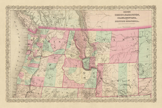
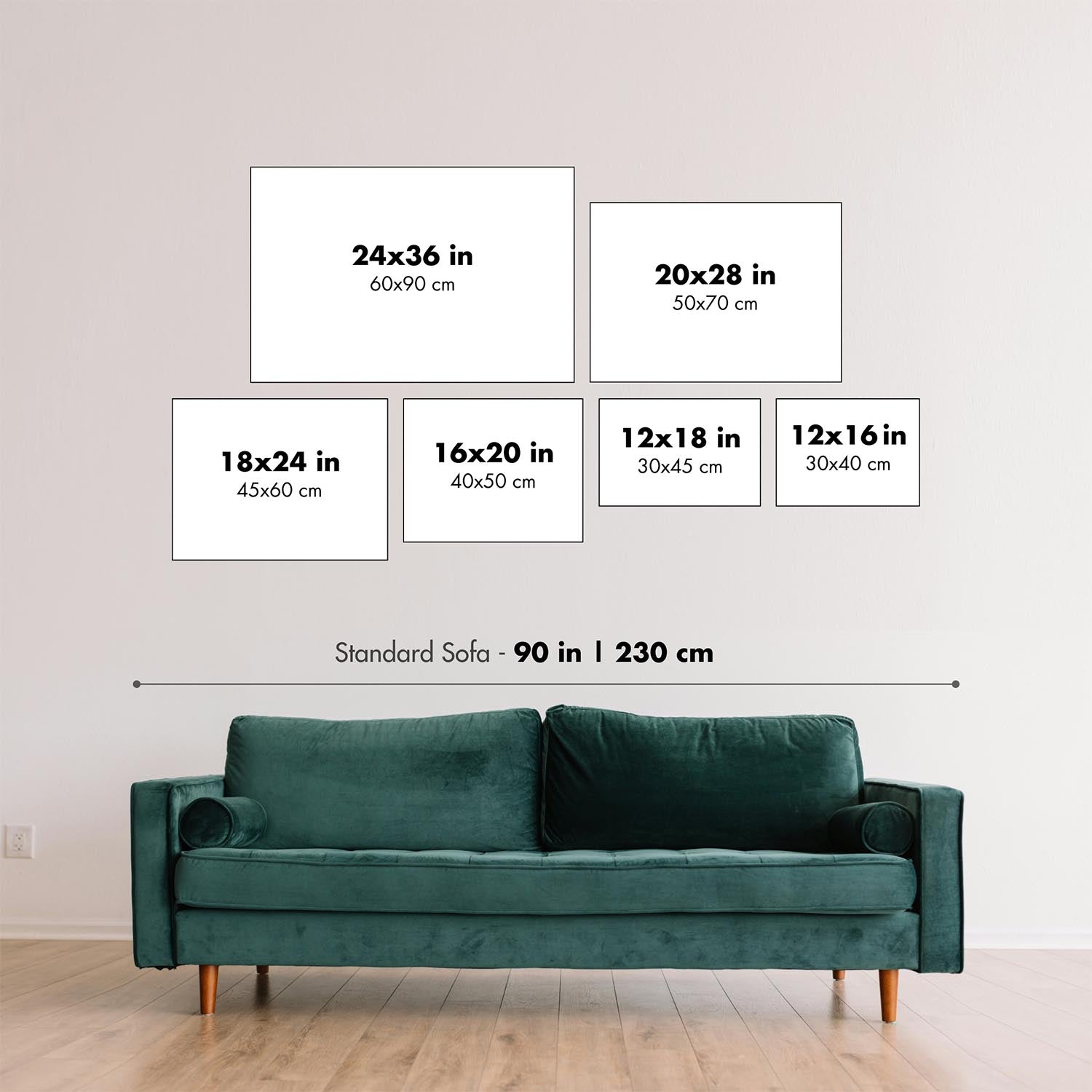
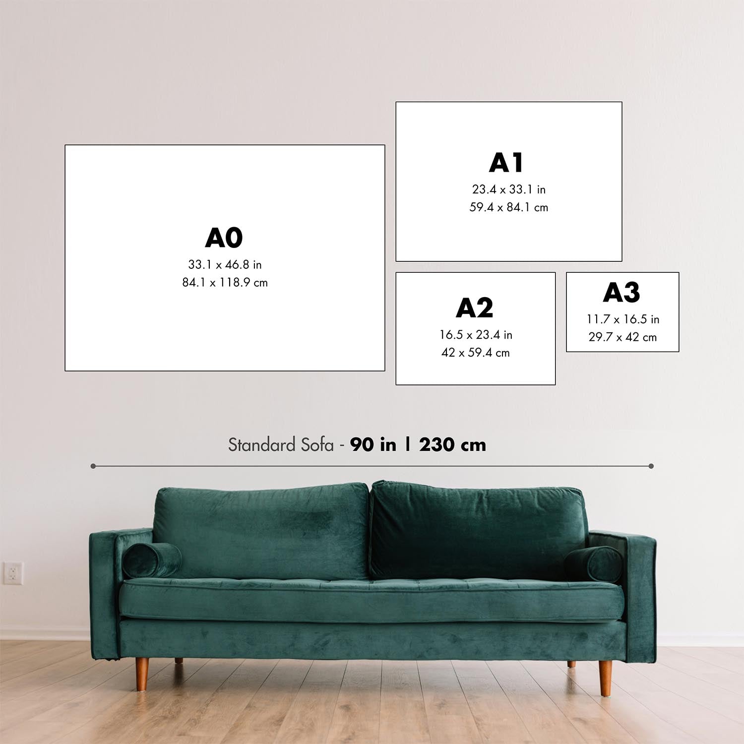
This map looks great at all sizes: 18x12in (46x30.5cm), 18x24in (45.5x61cm), 24x36in (61x91.5cm), 30x45in (76x114.5cm), 33x50in (84x127cm), 40x60in (102x153cm) and 47x70in (120x178cm), but it looks even better when printed large.
I can create beautiful, large prints of this map up to 100in (254cm). Please get in touch if you're looking for larger, customised or different framing options.
The model in the listing images is holding the 24x36in (61x91.5cm) version of this map.
The fifth listing image shows an example of my map personalisation service.
The labels on this map are very small at 12x16in (30.5x41cm). The map is still very attractive, but you may struggle to read the smallest letters. Please buy a larger map if it's important to be able to read the map easily.
If you’re looking for something slightly different, check out my main collection of USA and North America maps.
Please contact me to check if a certain location, landmark or feature is shown on this map.
This would make a wonderful birthday, Christmas, Father's Day, work leaving, anniversary or housewarming gift for someone from the areas covered by this map.
This map is available as a giclée print on acid free archival matte paper, or you can buy it framed. The frame is a nice, simple black frame that suits most aesthetics. Please get in touch if you'd like a different frame colour or material. My frames are glazed with super-clear museum-grade acrylic (perspex/acrylite), which is significantly less reflective than glass, safer, and will always arrive in perfect condition.
This map is also available as a float framed canvas, sometimes known as a shadow gap framed canvas or canvas floater. The map is printed on artist's cotton canvas and then stretched over a handmade box frame. We then "float" the canvas inside a wooden frame, which is available in a range of colours (black, dark brown, oak, antique gold and white). This is a wonderful way to present a map without glazing in front. See some examples of float framed canvas maps and explore the differences between my different finishes.
For something truly unique, this map is also available in "Unique 3D", our trademarked process that dramatically transforms the map so that it has a wonderful sense of depth. We combine the original map with detailed topography and elevation data, so that mountains and the terrain really "pop". For more info and examples of 3D maps, check my Unique 3D page.
For most orders, delivery time is about 3 working days. Personalised and customised products take longer, as I have to do the personalisation and send it to you for approval, which usually takes 1 or 2 days.
Please note that very large framed orders usually take longer to make and deliver.
If you need your order to arrive by a certain date, please contact me before you order so that we can find the best way of making sure you get your order in time.
I print and frame maps and artwork in 23 countries around the world. This means your order will be made locally, which cuts down on delivery time and ensures that it won't be damaged during delivery. You'll never pay customs or import duty, and we'll put less CO2 into the air.
All of my maps and art prints are well packaged and sent in a rugged tube if unframed, or surrounded by foam if framed.
I try to send out all orders within 1 or 2 days of receiving your order, though some products (like face masks, mugs and tote bags) can take longer to make.
If you select Express Delivery at checkout your order we will prioritise your order and send it out by 1-day courier (Fedex, DHL, UPS, Parcelforce).
Next Day delivery is also available in some countries (US, UK, Singapore, UAE) but please try to order early in the day so that we can get it sent out on time.
My standard frame is a gallery style black ash hardwood frame. It is simple and quite modern looking. My standard frame is around 20mm (0.8in) wide.
I use super-clear acrylic (perspex/acrylite) for the frame glass. It's lighter and safer than glass - and it looks better, as the reflectivity is lower.
Six standard frame colours are available for free (black, dark brown, dark grey, oak, white and antique gold). Custom framing and mounting/matting is available if you're looking for something else.
Most maps, art and illustrations are also available as a framed canvas. We use matte (not shiny) cotton canvas, stretch it over a sustainably sourced box wood frame, and then 'float' the piece within a wood frame. The end result is quite beautiful, and there's no glazing to get in the way.
All frames are provided "ready to hang", with either a string or brackets on the back. Very large frames will have heavy duty hanging plates and/or a mounting baton. If you have any questions, please get in touch.
See some examples of my framed maps and framed canvas maps.
Alternatively, I can also supply old maps and artwork on canvas, foam board, cotton rag and other materials.
If you want to frame your map or artwork yourself, please read my size guide first.
My maps are extremely high quality reproductions of original maps.
I source original, rare maps from libraries, auction houses and private collections around the world, restore them at my London workshop, and then use specialist giclée inks and printers to create beautiful maps that look even better than the original.
My maps are printed on acid-free archival matte (not glossy) paper that feels very high quality and almost like card. In technical terms the paper weight/thickness is 10mil/200gsm. It's perfect for framing.
I print with Epson ultrachrome giclée UV fade resistant pigment inks - some of the best inks you can find.
I can also make maps on canvas, cotton rag and other exotic materials.
Learn more about The Unique Maps Co.
Map personalisation
If you're looking for the perfect anniversary or housewarming gift, I can personalise your map to make it truly unique. For example, I can add a short message, or highlight an important location, or add your family's coat of arms.
The options are almost infinite. Please see my map personalisation page for some wonderful examples of what's possible.
To order a personalised map, select "personalise your map" before adding it to your basket.
Get in touch if you're looking for more complex customisations and personalisations.
Map ageing
I have been asked hundreds of times over the years by customers if they could buy a map that looks even older.
Well, now you can, by selecting Aged before you add a map to your basket.
All the product photos you see on this page show the map in its Original form. This is what the map looks like today.
If you select Aged, I will age your map by hand, using a special and unique process developed through years of studying old maps, talking to researchers to understand the chemistry of aging paper, and of course... lots of practice!
If you're unsure, stick to the Original colour of the map. If you want something a bit darker and older looking, go for Aged.
If you are not happy with your order for any reason, contact me for a no-quibble refund. Please see our returns and refund policy for more information.
I am very confident you will like your restored map or art print. I have been doing this since 1984. I'm a 5-star Etsy seller. I have sold tens of thousands of maps and art prints and have over 5,000 real 5-star reviews.
I use a unique process to restore maps and artwork that is massively time consuming and labour intensive. Hunting down the original maps and illustrations can take months. I use state of the art and eye-wateringly expensive technology to scan and restore them. As a result, I guarantee my maps and art prints are a cut above the rest - that's why I can offer a no-quibble refund.
Almost all of my maps and art prints look amazing at large sizes (200cm, 6.5ft+) and I can frame and deliver them to you as well, via special oversized courier. Contact me to discuss your specific needs.
Or try searching for something!


