


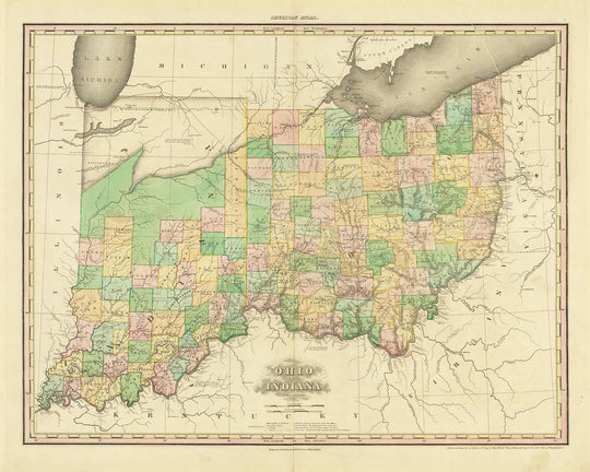


Old map of Ohio and Indiana by H.S. Tanner, 1820: Cincinnati, Columbus, Indianapolis, Cleveland, and Dayton
Buy 2, Get 1 More Free
If you add 2 items to your bag, you can add a third product for free. The discount is automatic - no code required.
This is equivalent to 33% off, which will be the largest discount available on my shop this year.
This works for all maps and artwork. You can order 3 of the same thing, or 3 different things.
Custom maps are excluded, as they're too time consuming to make and we'd prefer to take our time rather than rush through a lot of orders.
Contact me if you have any questions.
-
![]() Handmade in the USA
Handmade in the USA

-
FREE worldwide delivery in 2-3 days ⓘ
Free delivery in 2-3 days
Your map should be delivered in 2-3 working days with free delivery, worldwide.
We make maps by hand locally in 23 countries, including the USA
![]() . If you're buying a gift for someone in another country, we will make the map locally to them.
. If you're buying a gift for someone in another country, we will make the map locally to them.You will never pay import tax or customs duty.
Express delivery is available at checkout which can reduce the delivery time to 1-2 days.
Please note that personalised maps, and larger framed maps, can take longer to produce and deliver.
If you need your order to arrive by a certain date, contact me and we can discuss your options.
-
Complimentary gifting & design advice
ⓘ
Complimentary gifting & design advice
Available almost 24/7 on WhatsApp and email — we usually reply within minutes. We can help you:
- Choose a perfectly personalised gift
- Send a digital gift preview to the recipient
- Pick the ideal size for your wall
- Select the right finish and frame
Quick, friendly advice so you can order with confidence.
For last minute gifts, consider buying a digital gift card. We have over 5,000 maps and art prints to choose from.
-
90-day returns & 5-year guarantee
ⓘ
90-day returns & 5-year guarantee
Products can be returned within 90 days for a full refund, or exchange for another product.
We are also proud to offer a 5-year quality guarantee on our maps and art, covering defects in materials or workmanship under normal use.
For personalised and custom made items, we may offer you store credit or a non-expiring gift card, as we cannot resell personalised orders.
If you have any questions, get in touch. For more information, see our full returns & exchanges policy.

This is a museum-grade archival print from the original 1820 map — restored in our workshop and made to order on 220gsm archival matte paper or 400gsm artist's cotton canvas with pigment inks.
Professional framing & free personalisation available
1. Choose a size
2. Frame & personalize your map
Make your map unique with framing, hand-drawn customisation, vintage ageing, pop art text, unique 3D styling and more.


Gift message & custom finish

If you want to add a gift message, or a finish (jigsaw, aluminium board, etc.) that is not available here, please request it in the "order note" when you check out.
Every order is custom made, so if you need the size adjusted slightly, or printed on an unusual material, just let us know. We've done thousands of custom orders over the years, so there's (almost) nothing we can't manage.
You can also contact us before you order, if you prefer!

- Handmade locally. No import duty or tax
- FREE worldwide delivery
- 90-day returns & 5-year product guarantee
- Questions? WhatsApp me any time
Own a piece of history
7,000+ 5 star reviews


Discover the splendors of history with this exquisite 1820 map of Ohio and Indiana by famed cartographer H. S. Tanner. Breathtaking in its detail, this masterful creation paints a vivid picture of the early 19th-century Midwest, illuminating its unique geography and burgeoning settlements. The map offers an invaluable insight into the pioneering spirit of the period, as the United States was expanding westward. The period from 1810 to 1830 was a time of significant development in these regions, marked by the migration of settlers, the growth of communities, and the turbulent relations with Native American nations.
The rich patina of time has only enhanced the beauty of this map, which faithfully represents the historical boundaries of Ohio and Indiana. The great rivers – Ohio, Wabash, and Maumee – are delicately drawn, their winding paths charting the course of history itself. Numerous towns, counties, and settlements are meticulously noted, each with its unique story, making it more than a mere collector's piece; it is a journey back to the roots of these two pivotal states. The map also illustrates notable natural phenomena and landmarks that are today's prime tourist attractions, such as the Hocking Hills in Ohio and the Indiana Dunes.
Ohio:
- Cincinnati (1788): Known for its bustling river trade and as a gateway to the west. Today, it's Ohio's third-largest city.
- Columbus (1812): Chosen as the state capital for its central location, it is now the most populous city in Ohio.
- Cleveland (1796): Established by surveyors of the Connecticut Land Company. Today, it's a major U.S. city with a strong cultural scene.
- Dayton (1796): Birthplace of aviation pioneers, the Wright brothers.
- Zanesville (1797): Named after Ebenezer Zane, who opened the Zane Trace, a crucial pioneer route.
- Chillicothe (1796): Served as Ohio's first capital and a significant center for mound-building cultures.
- Steubenville (1797): Known for its historic downtown and 19th-century architecture.
- Marietta (1788): The first permanent settlement of the Northwest Territory.
- Lancaster (1800): Known for its numerous historic buildings and districts.
- Hamilton (1791): Home to Fort Hamilton, a supply depot during the Northwest Indian Wars.
- Warren (1799): A key location for the Connecticut Western Reserve's early development.
- Gallipolis (1790): Founded by French immigrants, known as the French 500.
- Lebanon (1802): The site of the famous Golden Lamb Inn, Ohio's oldest hotel.
- Xenia (1803): Historically significant for its involvement in the Underground Railroad.
- Newark (1802): Known for its series of ancient earthworks built by the Hopewell culture.
Indiana:
- Indianapolis (1820): Now the state capital and Indiana's most populous city.
- Vincennes (1732): The oldest continually inhabited European settlement in Indiana and once the capital of the Indiana Territory.
- Madison (1809): Known for its historic district, one of the largest National Historic Landmark districts in the U.S.
- Corydon (1808): Served as the second capital of Indiana and site of the only Civil War battle fought in the state.
- Brookville (1808): Known for its well-preserved Federal period architecture.
- New Albany (1813): Played a key role in the mid-19th century expansion of the Midwest's railway system.
- Jeffersonville (1802): The location of the Howard Shipyard, which produced steamboats throughout the 19th century.
- Lawrenceburg (1802): Known for its rich soil, it became a premier location for farming and winemaking.
- Terre Haute (1816): Home to one of the oldest colleges in the U.S., Indiana State University.
- Evansville (1817): Known for its 19th-century architecture, it's now the third-largest city in Indiana.
- Paoli (1816): Named after Pasquale Paoli Ash, the first white child born in Orange County.
- Lafayette (1825): Known for its vibrant downtown and historic neighborhoods.
- Bedford (1825): Known as the limestone capital of the world, with many of its structures made of local limestone.
- Salem (1814): A thriving hub of activity for early pioneers in Washington County.
- Portsmouth (1803): Located along the Ohio River, it was a pivotal shipping point in the 19th century.
Historical Events (1810-1830):
- War of 1812: In the war against Great Britain, Ohio and Indiana served as significant battlegrounds.
- Treaty of St. Mary's (1818): This led to the acquisition of a large part of present-day central Indiana from the Miami nation.
- Indiana Statehood (1816): Indiana was admitted as the 19th U.S. state.
- Erie Canal Completion (1825): It opened up a water route from the east coast to the Great Lakes, passing through Ohio and boosting its economy.
From intricate detailing to rich history, this Tanner map is a mesmerizing piece for collectors, historians, and enthusiasts of the past. Whether you wish to revisit the emergence of these frontier settlements or explore the geographical boundaries of the 1820s Midwest, this artifact delivers a deeply rewarding journey through time. This old map of Ohio and Indiana by H.S. Tanner truly captures the essence of an era marked by expansion, conflict, and the unyielding spirit of discovery.
Please double check the images to make sure that a specific town or place is shown on this map. You can also get in touch and ask us to check the map for you.
This map looks great at all sizes: 12x16in (30.5x41cm), 16x20in (40.5x51cm), 18x24in (45.5x61cm), 24x30in (61x76cm), 32x40in (81.5x102cm), 40x50in (102x127cm), 48x60in (122x153cm) and 56x70in (142x178cm), but it looks even better when printed large.
I can create beautiful, large prints of this map up to 100in (254cm). Please get in touch if you're looking for larger, customised or different framing options.
The model in the listing images is holding the 16x20in (40.5x51cm) version of this map.
The fifth listing image shows an example of my map personalisation service.
If you’re looking for something slightly different, check out my main collection of USA and North America maps.
Please contact me to check if a certain location, landmark or feature is shown on this map.
This would make a wonderful birthday, Christmas, Father's Day, work leaving, anniversary or housewarming gift for someone from the areas covered by this map.
This map is available as a giclée print on acid free archival matte paper, or you can buy it framed. The frame is a nice, simple black frame that suits most aesthetics. Please get in touch if you'd like a different frame colour or material. My frames are glazed with super-clear museum-grade acrylic (perspex/acrylite), which is significantly less reflective than glass, safer, and will always arrive in perfect condition.
This map is also available as a float framed canvas, sometimes known as a shadow gap framed canvas or canvas floater. The map is printed on artist's cotton canvas and then stretched over a handmade box frame. We then "float" the canvas inside a wooden frame, which is available in a range of colours (black, dark brown, oak, antique gold and white). This is a wonderful way to present a map without glazing in front. See some examples of float framed canvas maps and explore the differences between my different finishes.
For something truly unique, this map is also available in "Unique 3D", our trademarked process that dramatically transforms the map so that it has a wonderful sense of depth. We combine the original map with detailed topography and elevation data, so that mountains and the terrain really "pop". For more info and examples of 3D maps, check my Unique 3D page.
For most orders, delivery time is about 3 working days. Personalised and customised products take longer, as I have to do the personalisation and send it to you for approval, which usually takes 1 or 2 days.
Please note that very large framed orders usually take longer to make and deliver.
If you need your order to arrive by a certain date, please contact me before you order so that we can find the best way of making sure you get your order in time.
I print and frame maps and artwork in 23 countries around the world. This means your order will be made locally, which cuts down on delivery time and ensures that it won't be damaged during delivery. You'll never pay customs or import duty, and we'll put less CO2 into the air.
All of my maps and art prints are well packaged and sent in a rugged tube if unframed, or surrounded by foam if framed.
I try to send out all orders within 1 or 2 days of receiving your order, though some products (like face masks, mugs and tote bags) can take longer to make.
If you select Express Delivery at checkout your order we will prioritise your order and send it out by 1-day courier (Fedex, DHL, UPS, Parcelforce).
Next Day delivery is also available in some countries (US, UK, Singapore, UAE) but please try to order early in the day so that we can get it sent out on time.
My standard frame is a gallery style black ash hardwood frame. It is simple and quite modern looking. My standard frame is around 20mm (0.8in) wide.
I use super-clear acrylic (perspex/acrylite) for the frame glass. It's lighter and safer than glass - and it looks better, as the reflectivity is lower.
Six standard frame colours are available for free (black, dark brown, dark grey, oak, white and antique gold). Custom framing and mounting/matting is available if you're looking for something else.
Most maps, art and illustrations are also available as a framed canvas. We use matte (not shiny) cotton canvas, stretch it over a sustainably sourced box wood frame, and then 'float' the piece within a wood frame. The end result is quite beautiful, and there's no glazing to get in the way.
All frames are provided "ready to hang", with either a string or brackets on the back. Very large frames will have heavy duty hanging plates and/or a mounting baton. If you have any questions, please get in touch.
See some examples of my framed maps and framed canvas maps.
Alternatively, I can also supply old maps and artwork on canvas, foam board, cotton rag and other materials.
If you want to frame your map or artwork yourself, please read my size guide first.
My maps are extremely high quality reproductions of original maps.
I source original, rare maps from libraries, auction houses and private collections around the world, restore them at my London workshop, and then use specialist giclée inks and printers to create beautiful maps that look even better than the original.
My maps are printed on acid-free archival matte (not glossy) paper that feels very high quality and almost like card. In technical terms the paper weight/thickness is 10mil/200gsm. It's perfect for framing.
I print with Epson ultrachrome giclée UV fade resistant pigment inks - some of the best inks you can find.
I can also make maps on canvas, cotton rag and other exotic materials.
Learn more about The Unique Maps Co.
Map personalisation
If you're looking for the perfect anniversary or housewarming gift, I can personalise your map to make it truly unique. For example, I can add a short message, or highlight an important location, or add your family's coat of arms.
The options are almost infinite. Please see my map personalisation page for some wonderful examples of what's possible.
To order a personalised map, select "personalise your map" before adding it to your basket.
Get in touch if you're looking for more complex customisations and personalisations.
Map ageing
I have been asked hundreds of times over the years by customers if they could buy a map that looks even older.
Well, now you can, by selecting Aged before you add a map to your basket.
All the product photos you see on this page show the map in its Original form. This is what the map looks like today.
If you select Aged, I will age your map by hand, using a special and unique process developed through years of studying old maps, talking to researchers to understand the chemistry of aging paper, and of course... lots of practice!
If you're unsure, stick to the Original colour of the map. If you want something a bit darker and older looking, go for Aged.
If you are not happy with your order for any reason, contact me and I'll get it fixed ASAP, free of charge. Please see my returns and refund policy for more information.
I am very confident you will like your restored map or art print. I have been doing this since 1984. I'm a 5-star Etsy seller. I have sold tens of thousands of maps and art prints and have over 5,000 real 5-star reviews. My work has been featured in interior design magazines, on the BBC, and on the walls of dozens of 5-star hotels.
I use a unique process to restore maps and artwork that is massively time consuming and labour intensive. Hunting down the original maps and illustrations can take months. I use state of the art and eye-wateringly expensive technology to scan and restore them. As a result, I guarantee my maps and art prints are a cut above the rest. I stand by my products and will always make sure you're 100% happy with what you receive.
Almost all of my maps and art prints look amazing at large sizes (200cm, 6.5ft+) and I can frame and deliver them to you as well, via special oversized courier. Contact me to discuss your specific needs.
Or try searching for something!


