

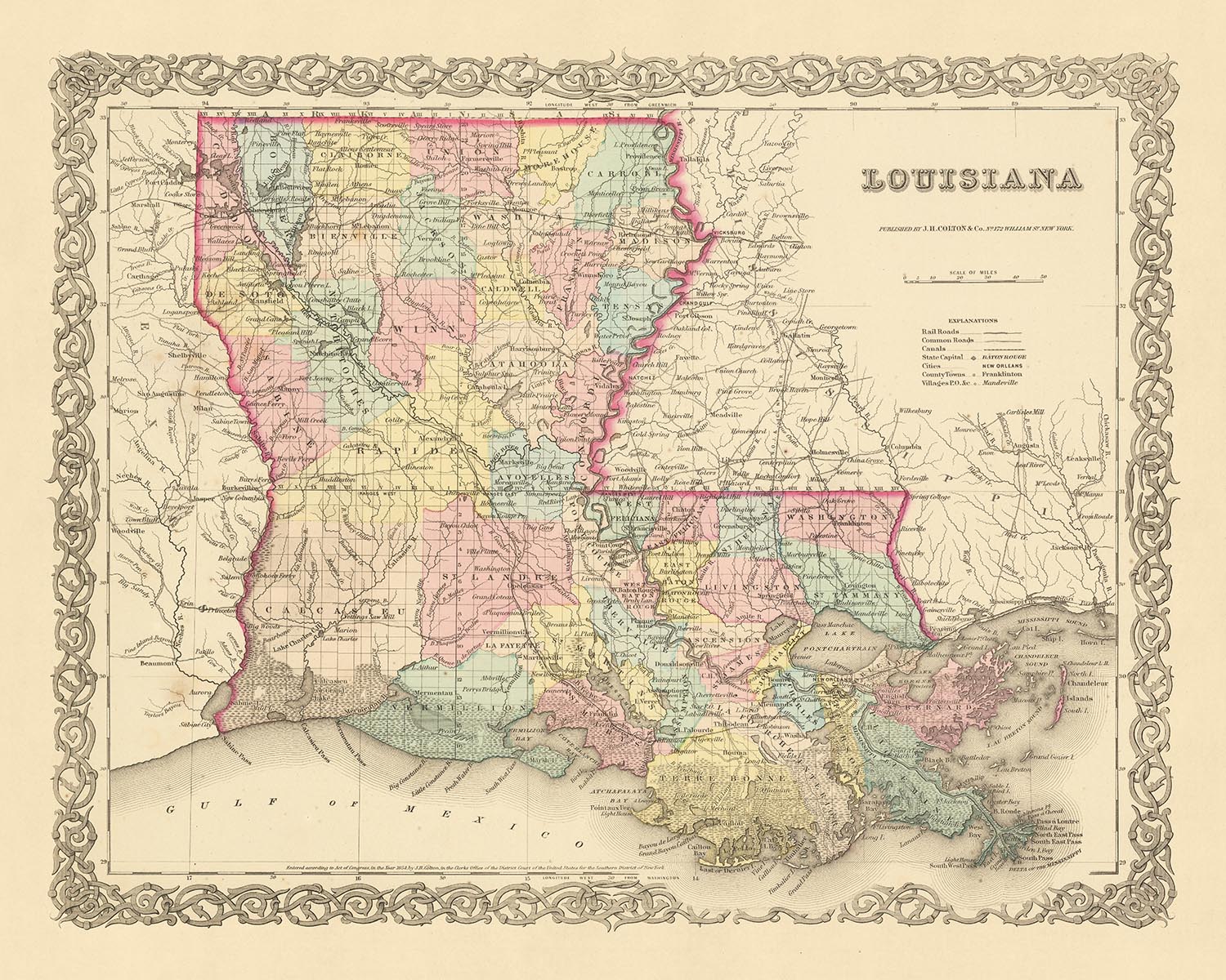


Old Map of Louisiana by J.H. Colton, 1855: New Orleans, Baton Rouge, Shreveport, Lafayette, Lake Charles
Christmas Express Delivery
You can order up until 10am on December 22 with Express Delivery to receive your order by Christmas.
Unframed products are much more likely to arrive by Christmas. Framed products may arrive on time, but they move more slowly, particularly when couriers are so overloaded with packages.
Personalised orders are unlikely to arrive on time (but if you absolutely must have a personalised product, please contact me and I'll do my best to help!)
Contact me for info on last-minute deliveries.
Spend $300, Save $60 Christmas Express Delivery available
Christmas Express Delivery
You can order up until 10am on December 22 with Express Delivery to receive your order by Christmas.
Unframed products are much more likely to arrive by Christmas. Framed products may arrive on time, but they move more slowly, particularly when couriers are so overloaded with packages.
Personalised orders are unlikely to arrive on time (but if you absolutely must have a personalised product, please contact me and I'll do my best to help!)
Contact me for info on last-minute deliveries.
Spend $300, Save $60

-
![]() Handmade in the USA
Handmade in the USA
-
FREE delivery in 3-4 days ⓘ
Free delivery in 3-4 days
Your map should be delivered in 3-4 working days with free delivery, worldwide.
Please use Express Delivery at checkout for Christmas orders. Framed orders may arrive with Express Delivery, but it is not guaranteed.
New for 2025: After you order, you can send a beautiful gift preview by email, if you're worried it won't arrive on time.
We make maps by hand locally in 23 countries, including the USA
![]() . If you're buying a gift for someone in another country, we will make the map locally to them.
. If you're buying a gift for someone in another country, we will make the map locally to them.You will never pay import tax or customs duty.
Check the Christmas delivery guide for order deadlines. Delivery times are starting to slow down, and will continue to slow down towards Christmas.
Express delivery is available at checkout which can reduce the delivery time to 1-2 days.
Please note that personalised maps, and larger framed maps, can take longer to produce and deliver.
If you need your order to arrive by a certain date, contact me and we can discuss your options.
-
FREE gift preview
ⓘ
Digital gift preview
New for 2025: After you complete your order, you can send a beautiful digital preview to the gift recipient. Just provide their email address and we'll do the rest. (Their email address will not be stored or used for any other purpose.)
This is perfect for Christmas gifting, particularly if you're concerned that your order might not arrive in time for Christmas.
-
90 day money back guarantee
ⓘ
90 days to return and refund
Products can be returned within 90 days for a full refund, or exchange for another product.
For personalised and custom made items, we may offer you store credit or a non-expiring gift card, as we cannot resell personalised orders.
If you have any questions, get in touch. For more information, see our full returns & exchanges policy.

My maps are rare, museum-grade, restored old maps sourced from libraries, auction houses and private collections across the globe.
Framing & free personalisation available
1. Select your size
2. Frame & personalize your map
There is limited framing & personalisation capacity available. Order by 10am tomorrow for Christmas delivery.


Gift message & custom finish

If you want to add a gift message, or a finish (jigsaw, aluminium board, etc.) that is not available here, please request it in the "order note" when you check out.
Every order is custom made, so if you need the size adjusted slightly, or printed on an unusual material, just let us know. We've done thousands of custom orders over the years, so there's (almost) nothing we can't manage.
You can also contact us before you order, if you prefer!

- Handmade locally. No import duty or tax
- FREE Delivery by Christmas
- Love it or your money back (90 days)
- Questions? WhatsApp me any time
Own a piece of history
5,000+ 5 star reviews


Immerse yourself in the rich tapestry of American history with this captivating old map of Louisiana, crafted by the eminent mapmaker J.H. Colton in 1855. A master of his craft, Colton is widely recognized as the finest American mapmaker of his era, and his meticulous attention to detail and precision is evident in this remarkable piece. This map hails from a time when the United States was in its nascent stages, with many of the settlements we know today yet to be founded.
This map offers a unique snapshot of Louisiana in 1855, a period of significant change and growth. It provides a fascinating insight into the region's development, highlighting five of the most notable settlements of the time: New Orleans, Baton Rouge, Shreveport, Lafayette, and Lake Charles. Each of these settlements played a crucial role in shaping the state's history and their prominence on the map underlines their importance during this era.
However, it's important to note that over the past 150 years, many names and borders have changed. This map serves as a testament to the fluidity of history, capturing a moment in time before these transformations took place. It's a window into a bygone era, offering viewers a chance to trace the evolution of Louisiana from its early days to the vibrant state we know today.
This exquisite piece is not just a map, but a piece of history, a work of art that invites you to delve into the past and explore the roots of Louisiana. It's a treasure trove of information, showcasing the state's topography, settlements, and transportation routes as they existed in 1855. Colton's expert craftsmanship and the map's historical significance make it a must-have for any serious collector or history enthusiast.
Experience the thrill of discovery as you navigate the intricate details of this map, uncovering the stories of Louisiana's past. Whether you're a seasoned collector or simply a lover of history, this old map of Louisiana by J.H. Colton is sure to captivate and inspire. It's more than just a map - it's a journey into the past, a tangible connection to the history of the United States.
In conclusion, this old map of Louisiana by J.H. Colton, 1855, is an invaluable piece of history. It's a testament to the state's past, capturing the essence of Louisiana in the mid-19th century. With its rich details and historical significance, it's a stunning addition to any collection, promising to delight and fascinate for years to come.
Settlements in Louisiana
- New Orleans (1718): Known as "La Nouvelle-Orléans" in French, it's the largest city in Louisiana and a major port.
- Baton Rouge (1699): Originally called "Istrouma" by the indigenous people, it's the capital city of Louisiana.
- Shreveport (1836): Founded as a steamboat captain's settlement, it's now the third-largest city in Louisiana.
- Lafayette (1821): Originally called Vermilionville, it's known for its Cajun and Creole cultures.
- Lake Charles (1861): Known for its petroleum refining industries and tourism.
- Natchitoches (1714): The oldest permanent settlement in the Louisiana Purchase territory.
- Alexandria (1805): Established as a trading post by Alexander Fulton.
- Monroe (1785): Known as Fort Miro until 1819, it's the eighth-largest city in Louisiana.
- Opelousas (1720): Known as "Le Poste des Opelousas", it's the third-oldest city in Louisiana.
- Thibodaux (1810): Originally called Thibodeauxville, it's the parish seat of Lafourche Parish.
- Minden (1836): Known for its historic downtown area.
- Houma (1810): Named after the native Houma people.
- Breaux Bridge (1829): Known as the "Crawfish Capital of the World".
- St. Martinville (1817): Known as "Petit Paris" during the French colonial period.
- Donaldsonville (1806): Once the capital of Louisiana (1830-1831).
- Plaquemine (1775): Known for its historic sites like the Plaquemine Lock.
- St. Francisville (1809): Known for its antebellum homes.
- DeRidder (1898): Known for its historic Gothic jail.
- Jeanerette (1830): Known as "Sugar City" for its sugarcane industry.
- Franklin (1808): Named after Benjamin Franklin, it's known for its historic districts.
Native American Tribes
- Choctaw: One of the largest tribes in the Southeast, known for their mound-building culture.
- Chitimacha: Known for their basket weaving skills.
- Houma: The tribe from which the city of Houma gets its name.
- Caddo: The tribe that lived in the northwestern part of the state.
- Tunica-Biloxi: Known for their trade networks.
Natural Attractions
- Mississippi River: The second-longest river in North America.
- Atchafalaya Basin: The largest wetland and swamp in the United States.
- Bayou Teche: A 125-mile long waterway in the southern part of the state.
- Lake Pontchartrain: The second-largest saltwater lake in the United States.
- Kisatchie National Forest: The only National forest in Louisiana.
Historical Events (1810-1855)
- Battle of New Orleans (1815): The final major battle of the War of 1812.
- Admission of Louisiana to the Union (1812): Louisiana became the 18th state of the United States.
- Louisiana Purchase (1803): The United States acquired approximately 828,000,000 square miles of territory from France.
Please double check the images to make sure that a specific town or place is shown on this map. You can also get in touch and ask us to check the map for you.
This map looks great at all sizes: 12x16in (30.5x41cm), 16x20in (40.5x51cm), 18x24in (45.5x61cm), 24x30in (61x76cm), 32x40in (81.5x102cm), 40x50in (102x127cm), 48x60in (122x153cm) and 56x70in (142x178cm), but it looks even better when printed large.
I can create beautiful, large prints of this map up to 70in (178cm). Please get in touch if you're looking for larger, customised or different framing options.
The model in the listing images is holding the 16x20in (40.5x51cm) version of this map.
The fifth listing image shows an example of my map personalisation service.
If you’re looking for something slightly different, check out my main collection of USA and North America maps.
Please contact me to check if a certain location, landmark or feature is shown on this map.
This would make a wonderful birthday, Christmas, Father's Day, work leaving, anniversary or housewarming gift for someone from the areas covered by this map.
This map is available as a giclée print on acid free archival matte paper, or you can buy it framed. The frame is a nice, simple black frame that suits most aesthetics. Please get in touch if you'd like a different frame colour or material. My frames are glazed with super-clear museum-grade acrylic (perspex/acrylite), which is significantly less reflective than glass, safer, and will always arrive in perfect condition.
This map is also available as a float framed canvas, sometimes known as a shadow gap framed canvas or canvas floater. The map is printed on artist's cotton canvas and then stretched over a handmade box frame. We then "float" the canvas inside a wooden frame, which is available in a range of colours (black, dark brown, oak, antique gold and white). This is a wonderful way to present a map without glazing in front. See some examples of float framed canvas maps and explore the differences between my different finishes.
For something truly unique, this map is also available in "Unique 3D", our trademarked process that dramatically transforms the map so that it has a wonderful sense of depth. We combine the original map with detailed topography and elevation data, so that mountains and the terrain really "pop". For more info and examples of 3D maps, check my Unique 3D page.
For most orders, delivery time is about 3 working days. Personalised and customised products take longer, as I have to do the personalisation and send it to you for approval, which usually takes 1 or 2 days.
Please note that very large framed orders usually take longer to make and deliver.
If you need your order to arrive by a certain date, please contact me before you order so that we can find the best way of making sure you get your order in time.
I print and frame maps and artwork in 23 countries around the world. This means your order will be made locally, which cuts down on delivery time and ensures that it won't be damaged during delivery. You'll never pay customs or import duty, and we'll put less CO2 into the air.
All of my maps and art prints are well packaged and sent in a rugged tube if unframed, or surrounded by foam if framed.
I try to send out all orders within 1 or 2 days of receiving your order, though some products (like face masks, mugs and tote bags) can take longer to make.
If you select Express Delivery at checkout your order we will prioritise your order and send it out by 1-day courier (Fedex, DHL, UPS, Parcelforce).
Next Day delivery is also available in some countries (US, UK, Singapore, UAE) but please try to order early in the day so that we can get it sent out on time.
My standard frame is a gallery style black ash hardwood frame. It is simple and quite modern looking. My standard frame is around 20mm (0.8in) wide.
I use super-clear acrylic (perspex/acrylite) for the frame glass. It's lighter and safer than glass - and it looks better, as the reflectivity is lower.
Six standard frame colours are available for free (black, dark brown, dark grey, oak, white and antique gold). Custom framing and mounting/matting is available if you're looking for something else.
Most maps, art and illustrations are also available as a framed canvas. We use matte (not shiny) cotton canvas, stretch it over a sustainably sourced box wood frame, and then 'float' the piece within a wood frame. The end result is quite beautiful, and there's no glazing to get in the way.
All frames are provided "ready to hang", with either a string or brackets on the back. Very large frames will have heavy duty hanging plates and/or a mounting baton. If you have any questions, please get in touch.
See some examples of my framed maps and framed canvas maps.
Alternatively, I can also supply old maps and artwork on canvas, foam board, cotton rag and other materials.
If you want to frame your map or artwork yourself, please read my size guide first.
My maps are extremely high quality reproductions of original maps.
I source original, rare maps from libraries, auction houses and private collections around the world, restore them at my London workshop, and then use specialist giclée inks and printers to create beautiful maps that look even better than the original.
My maps are printed on acid-free archival matte (not glossy) paper that feels very high quality and almost like card. In technical terms the paper weight/thickness is 10mil/200gsm. It's perfect for framing.
I print with Epson ultrachrome giclée UV fade resistant pigment inks - some of the best inks you can find.
I can also make maps on canvas, cotton rag and other exotic materials.
Learn more about The Unique Maps Co.
Map personalisation
If you're looking for the perfect anniversary or housewarming gift, I can personalise your map to make it truly unique. For example, I can add a short message, or highlight an important location, or add your family's coat of arms.
The options are almost infinite. Please see my map personalisation page for some wonderful examples of what's possible.
To order a personalised map, select "personalise your map" before adding it to your basket.
Get in touch if you're looking for more complex customisations and personalisations.
Map ageing
I have been asked hundreds of times over the years by customers if they could buy a map that looks even older.
Well, now you can, by selecting Aged before you add a map to your basket.
All the product photos you see on this page show the map in its Original form. This is what the map looks like today.
If you select Aged, I will age your map by hand, using a special and unique process developed through years of studying old maps, talking to researchers to understand the chemistry of aging paper, and of course... lots of practice!
If you're unsure, stick to the Original colour of the map. If you want something a bit darker and older looking, go for Aged.
If you are not happy with your order for any reason, contact me and I'll get it fixed ASAP, free of charge. Please see my returns and refund policy for more information.
I am very confident you will like your restored map or art print. I have been doing this since 1984. I'm a 5-star Etsy seller. I have sold tens of thousands of maps and art prints and have over 5,000 real 5-star reviews. My work has been featured in interior design magazines, on the BBC, and on the walls of dozens of 5-star hotels.
I use a unique process to restore maps and artwork that is massively time consuming and labour intensive. Hunting down the original maps and illustrations can take months. I use state of the art and eye-wateringly expensive technology to scan and restore them. As a result, I guarantee my maps and art prints are a cut above the rest. I stand by my products and will always make sure you're 100% happy with what you receive.
Almost all of my maps and art prints look amazing at large sizes (200cm, 6.5ft+) and I can frame and deliver them to you as well, via special oversized courier. Contact me to discuss your specific needs.
Or try searching for something!


