


Old OS Map of Kent, England by Bartholomew, 1901: Thames Estuary, Dover, Canterbury, North Downs, Weald, Isle of Sheppey

-
![]() Handmade in the USA
Handmade in the USA
-
FREE worldwide delivery in 2-3 days ⓘ
Free delivery in 2-3 days
Your map should be delivered in 2-3 working days with free delivery, worldwide.
We make maps by hand locally in 23 countries, including the USA
![]() . If you're buying a gift for someone in another country, we will make the map locally to them.
. If you're buying a gift for someone in another country, we will make the map locally to them.You will never pay import tax or customs duty.
Express delivery is available at checkout which can reduce the delivery time to 1-2 days.
Please note that personalised maps, and larger framed maps, can take longer to produce and deliver.
If you need your order to arrive by a certain date, contact me and we can discuss your options.
-
90 day money back guarantee
ⓘ
90 days to return and refund
Products can be returned within 90 days for a full refund, or exchange for another product.
For personalised or custom made items, we may offer you store credit or a non-expiring gift card, as we cannot resell personalised orders.
If you have any questions, get in touch. For more information, see our full returns & exchanges policy.

My maps are rare, museum-grade, restored old maps sourced from libraries, auction houses and private collections across the globe.
Framing & free personalisation available
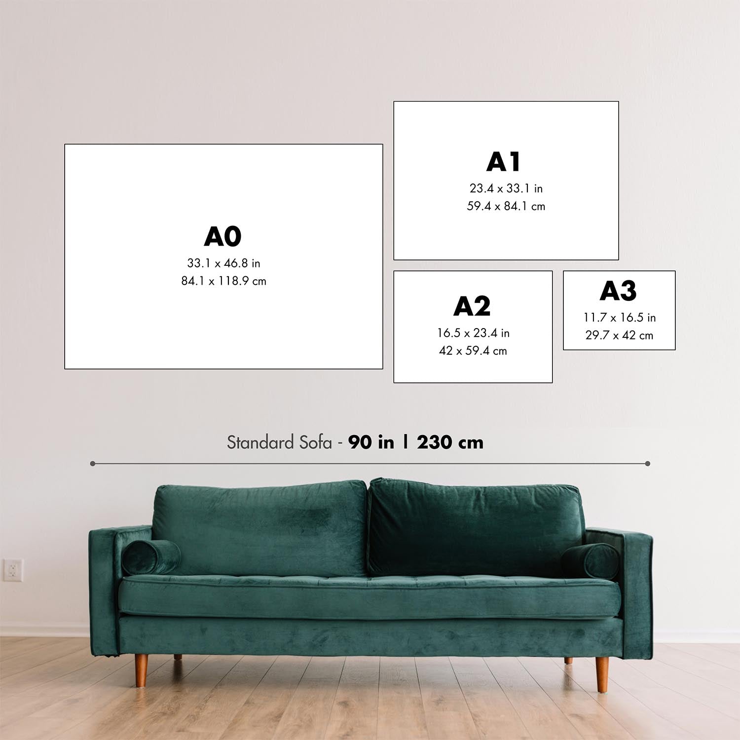
1. Select your size
2. Frame & personalize your map
Make your map unique with framing, hand-drawn customisation, vintage ageing, pop art text, unique 3D styling and moreGift message & custom finish

If you want to add a gift message, or a finish (jigsaw, aluminium board, etc.) that is not available here, please request it in the "order note" when you check out.
Every order is custom made, so if you need the size adjusted slightly, or printed on an unusual material, just let us know. We've done thousands of custom orders over the years, so there's (almost) nothing we can't manage.
You can also contact us before you order, if you prefer!

- Handmade locally. No import duty or tax
- FREE Delivery. Arrives in 2-3 days
- Love it or your money back
- Questions? WhatsApp me any time
Own a piece of history
5,000+ 5 star reviews


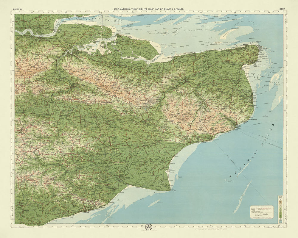
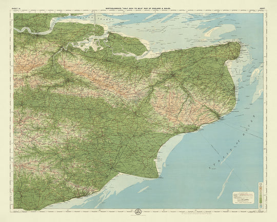
Sheet 31 - Kent, crafted by the esteemed cartographer JG Bartholomew in 1901, stands as a testament to the rich historical and geographical tapestry of Kent. Bartholomew, renowned for his innovative and detailed cartographic works, has masterfully encapsulated the essence of this English county with his half-inch to the mile scale map. This map, part of Bartholomew's flagship series, was particularly popular among cyclists and tourists of the early 20th century, offering a vivid and precise representation of the landscape, enhanced by a subtle gradation of color bands to depict varying elevations.
The map's design is both functional and aesthetically pleasing, showcasing Bartholomew's signature style of using different layers of color to represent landscape relief. This innovative approach allows viewers to easily discern the topographical nuances of Kent, from the rolling North Downs to the dense forestlands of the Weald. The map's clarity and attractiveness are further enhanced by its detailed political and physical features, making it not only a practical tool for navigation but also a work of art in its own right.
Kent, often referred to as the "Garden of England," is richly depicted in this map, highlighting its diverse geographical features and historical landmarks. The Thames Estuary and the Strait of Dover are prominently featured, emphasizing Kent's strategic importance as a gateway to the continent. The map also details the North Downs, a chalk ridge that has shaped the county's landscape and history, as well as the low-lying Romney Marsh, known for its unique ecosystem and historical significance.
This map is not just a geographical representation but a historical document that captures the essence of Kent at the turn of the 20th century. It includes notable features such as the ancient Pilgrims' Way, the Royal Military Canal, and the iconic White Cliffs of Dover. The map also marks significant historical sites like the Battle of Hastings and the Battle of Medway, providing a glimpse into the county's storied past. Additionally, it showcases the High Weald Area of Outstanding Natural Beauty and the Kent Downs, underscoring the region's natural splendor.
Bartholomew's map of Kent is a treasure trove of information, meticulously detailing the county's cities, towns, and villages. From the bustling streets of Maidstone and Canterbury to the serene coastal towns of Margate and Folkestone, the map offers a comprehensive view of Kent's human settlements. It also highlights the intricate network of roads and railways that connect these communities, reflecting the county's development and growth during the early 20th century. This map is a valuable piece for any collector or enthusiast of historical cartography, offering a unique window into the past.
Cities and towns on this map
- Maidstone
- Gillingham
- Dartford
- Chatham
- Ashford
- Gravesend
- Folkestone
- Canterbury
- Rochester
- Margate
- Tonbridge
- Dover
- Ramsgate
- Broadstairs
- Sevenoaks
- Sittingbourne
- Herne Bay
- Tunbridge Wells
- Deal
- Whitstable
- Hythe
- Sandwich
- Faversham
- Tenterden
- Edenbridge
- West Malling
- New Romney
- Queenborough
- Cranbrook
- Minster
- Lydd
- Rainham
- Swanley
- Snodland
- Southborough
- Northfleet
- Westgate-on-Sea
- Staplehurst
- Paddock Wood
- Aylesford
- Lenham
- Westerham
- Charing
- Headcorn
- Hawkhurst
- East Peckham
- Wye
- Newington
- Harrietsham
- Pluckley
- Biddenden
- Chilham
- Elham
- Lyminge
- Wingham
- Hoo St Werburgh
- Meopham
- Eynsford
- Otford
- Shoreham
- Brasted
- Borough Green
- Kingsdown
- Bearsted
- Boxley
- Ditton
- Hollingbourne
- Marden
- East Farleigh
- West Farleigh
- Yalding
- Linton
- Staplehurst
- Boughton Monchelsea
- Chart Sutton
- Headcorn
- Biddenden
- Smarden
- Egerton
- Pluckley
- Charing
- Lenham
- Harrietsham
- Hollingbourne
- Bearsted
- Boxley
- Detling
- Thurnham
- Bredhurst
- Walderslade
- Lordswood
- Hempstead
- Rainham
- Upchurch
- Lower Halstow
- Newington
- Hartlip
- Sittingbourne
- Teynham
- Faversham
- Ospringe
- Boughton-under-Blean
- Hernhill
- Graveney
- Whitstable
- Tankerton
- Chestfield
- Swalecliffe
- Blean
- Rough Common
- Harbledown
- Canterbury
- Sturry
- Hersden
- Upstreet
- Sarre
- Minster
- Birchington
- Westgate-on-Sea
- Margate
- Cliftonville
- Broadstairs
- Ramsgate
- Sandwich
- Deal
- Walmer
- Kingsdown
- Ringwould
- St Margaret's at Cliffe
- Dover
- Guston
- Whitfield
- Temple Ewell
- Lydden
- Shepherdswell
- Eythorne
- Elvington
- Nonington
- Aylesham
- Wingham
- Ash
- Staple
- Goodnestone
- Adisham
- Bekesbourne
- Littlebourne
- Ickham
- Wickhambreaux
- Stodmarsh
- Fordwich
- Hersden
- Upstreet
- Chislet
- Reculver
- Hoath
- Bishopstone
- Herne Bay
- Beltinge
- Eddington
- Greenhill
- Broomfield
- Herne
- Broomfield
- Herne
- Sturry
- Broad Oak
- Tyler Hill
- Rough Common
- Harbledown
- Chartham
- Shalmsford Street
- Chilham
- Old Wives Lees
- Selling
- Sheldwich
- Badlesmere
- Leaveland
- Throwley
- Eastling
- Newnham
- Doddington
- Lynsted
- Teynham
- Conyer
- Sittingbourne
- Milton Regis
- Kemsley
- Iwade
- Bobbing
- Lower Halstow
- Upchurch
- Newington
- Hartlip
- Rainham
- Hempstead
- Walderslade
- Lordswood
- Bredhurst
- Thurnham
- Detling
- Boxley
- Bearsted
- Hollingbourne
- Harrietsham
- Lenham
- Charing
- Pluckley
- Egerton
- Smarden
- Biddenden
- Headcorn
- Staplehurst
- Marden
- Yalding
- East Farleigh
- West Farleigh
- Barming
- East Malling
- West Malling
- Kings Hill
- Leybourne
- Larkfield
- Ditton
- Aylesford
- Burham
- Wouldham
- Snodland
- **Hallin
Notable Features & Landmarks
- The Thames Estuary, showing the confluence of the River Thames with the North Sea.
- The Strait of Dover, indicating the narrowest part of the English Channel.
- The North Downs, a prominent chalk ridge running across Kent.
- The Weald, a historically significant area of dense forestland.
- The Isle of Sheppey, located in the Thames Estuary.
- The Isle of Thanet, historically an island, now part of the mainland.
- The Pilgrims' Way, an ancient trackway that runs along the North Downs.
- Romney Marsh, a low-lying coastal area in the southeast of Kent.
- The Royal Military Canal, constructed for defense during the Napoleonic Wars.
- The White Cliffs of Dover, iconic chalk cliffs along the southeastern coast.
- High Weald Area of Outstanding Natural Beauty, a designated protected area.
- The Medway River, an important waterway flowing through Kent.
- The Cinque Ports, a historic series of coastal towns in Kent.
- The site of the Battle of Hastings (1066), near the eastern edge of the map.
- The site of the Battle of Medway (43 AD), near the Medway River.
- The ancient Roman road, Watling Street, running through Kent.
- Historic castles, including Dover Castle and Leeds Castle.
- The Kent Downs, an Area of Outstanding Natural Beauty.
- The site of Canterbury Cathedral, a UNESCO World Heritage Site.
Historical and design context
- Scale and purpose: A clear, attractive, and colorful map at the half-inch to the mile scale (1:126,720). These maps were popular with cyclists and tourists and became Bartholomew's flagship series.
- Creation date: 1901
- Mapmaker/Publisher: JG Bartholomew. Bartholomew was a renowned cartographer known for his innovative and detailed maps.
- Landscape representation: The half-inch maps were distinctive for using different layers of color to represent landscape relief, with a subtle and innovative gradation of color bands used to show land at different heights.
- Base map: The map is based on a reduced Ordnance Survey map from the same period.
- Orientation and coverage: This is a landscape map that covers (182) miles from north to south, and (262) miles from west to east.
- Regions shown: The map covers the county of Kent in England, including parts of the Thames Estuary and the Strait of Dover.
- Design and style: The map features a detailed political and physical representation, with clear labeling and color gradations to show elevation and terrain.
- Historical significance: This map is significant for its detailed representation of the landscape and infrastructure of Kent at the beginning of the 20th century, reflecting the cartographic advancements of the time.
Please double check the images to make sure that a specific town or place is shown on this map. You can also get in touch and ask us to check the map for you.
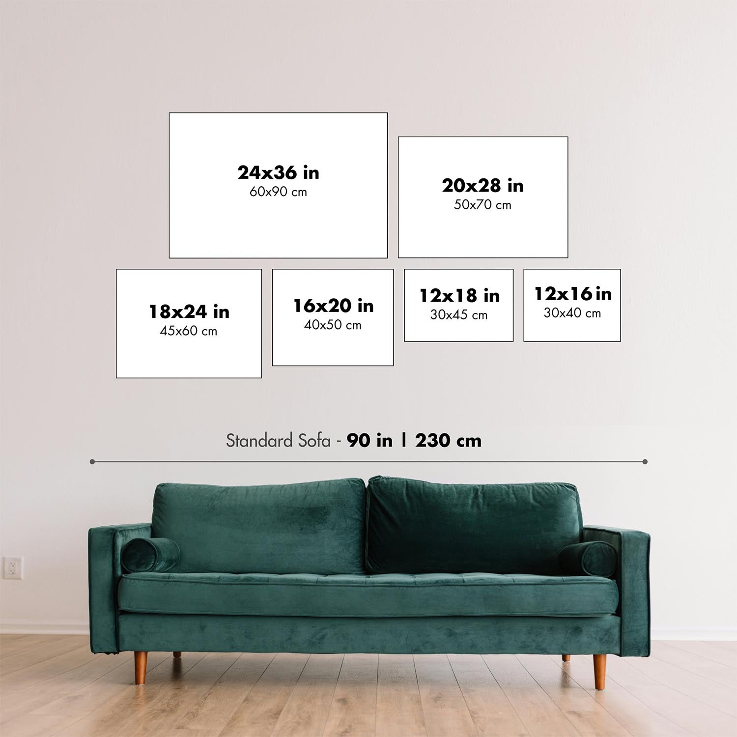
This map looks great at every size, but I always recommend going for a larger size if you have space. That way you can easily make out all of the details.
This map looks amazing at sizes all the way up to 70in (180cm). If you are looking for a larger map, please get in touch.
Please note: the labels on this map are hard to read if you order a map that is 20in (50cm) or smaller. The map is still very attractive, but if you would like to read the map easily, please buy a larger size.
The model in the listing images is holding the 16x20in (40x50cm) version of this map.
The fifth listing image shows an example of my map personalisation service.
If you’re looking for something slightly different, check out my collection of the best old maps to see if something else catches your eye.
Please contact me to check if a certain location, landmark or feature is shown on this map.
This would make a wonderful birthday, Christmas, Father's Day, work leaving, anniversary or housewarming gift for someone from the areas covered by this map.
This map is available as a giclée print on acid free archival matte paper, or you can buy it framed. The frame is a nice, simple black frame that suits most aesthetics. Please get in touch if you'd like a different frame colour or material. My frames are glazed with super-clear museum-grade acrylic (perspex/acrylite), which is significantly less reflective than glass, safer, and will always arrive in perfect condition.
This map is also available as a float framed canvas, sometimes known as a shadow gap framed canvas or canvas floater. The map is printed on artist's cotton canvas and then stretched over a handmade box frame. We then "float" the canvas inside a wooden frame, which is available in a range of colours (black, dark brown, oak, antique gold and white). This is a wonderful way to present a map without glazing in front. See some examples of float framed canvas maps and explore the differences between my different finishes.
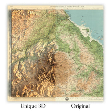
For something truly unique, this map is also available in "Unique 3D", our trademarked process that dramatically transforms the map so that it has a wonderful sense of depth. We combine the original map with detailed topography and elevation data, so that mountains and the terrain really "pop". For more info and examples of 3D maps, check my Unique 3D page.
For most orders, delivery time is about 3 working days. Personalised and customised products take longer, as I have to do the personalisation and send it to you for approval, which usually takes 1 or 2 days.
Please note that very large framed orders usually take longer to make and deliver.
If you need your order to arrive by a certain date, please contact me before you order so that we can find the best way of making sure you get your order in time.
I print and frame maps and artwork in 23 countries around the world. This means your order will be made locally, which cuts down on delivery time and ensures that it won't be damaged during delivery. You'll never pay customs or import duty, and we'll put less CO2 into the air.
All of my maps and art prints are well packaged and sent in a rugged tube if unframed, or surrounded by foam if framed.
I try to send out all orders within 1 or 2 days of receiving your order, though some products (like face masks, mugs and tote bags) can take longer to make.
If you select Express Delivery at checkout your order we will prioritise your order and send it out by 1-day courier (Fedex, DHL, UPS, Parcelforce).
Next Day delivery is also available in some countries (US, UK, Singapore, UAE) but please try to order early in the day so that we can get it sent out on time.
My standard frame is a gallery style black ash hardwood frame. It is simple and quite modern looking. My standard frame is around 20mm (0.8in) wide.
I use super-clear acrylic (perspex/acrylite) for the frame glass. It's lighter and safer than glass - and it looks better, as the reflectivity is lower.
Six standard frame colours are available for free (black, dark brown, dark grey, oak, white and antique gold). Custom framing and mounting/matting is available if you're looking for something else.
Most maps, art and illustrations are also available as a framed canvas. We use matte (not shiny) cotton canvas, stretch it over a sustainably sourced box wood frame, and then 'float' the piece within a wood frame. The end result is quite beautiful, and there's no glazing to get in the way.
All frames are provided "ready to hang", with either a string or brackets on the back. Very large frames will have heavy duty hanging plates and/or a mounting baton. If you have any questions, please get in touch.
See some examples of my framed maps and framed canvas maps.
Alternatively, I can also supply old maps and artwork on canvas, foam board, cotton rag and other materials.
If you want to frame your map or artwork yourself, please read my size guide first.
My maps are extremely high quality reproductions of original maps.
I source original, rare maps from libraries, auction houses and private collections around the world, restore them at my London workshop, and then use specialist giclée inks and printers to create beautiful maps that look even better than the original.
My maps are printed on acid-free archival matte (not glossy) paper that feels very high quality and almost like card. In technical terms the paper weight/thickness is 10mil/200gsm. It's perfect for framing.
I print with Epson ultrachrome giclée UV fade resistant pigment inks - some of the best inks you can find.
I can also make maps on canvas, cotton rag and other exotic materials.
Learn more about The Unique Maps Co.
Map personalisation
If you're looking for the perfect anniversary or housewarming gift, I can personalise your map to make it truly unique. For example, I can add a short message, or highlight an important location, or add your family's coat of arms.
The options are almost infinite. Please see my map personalisation page for some wonderful examples of what's possible.
To order a personalised map, select "personalise your map" before adding it to your basket.
Get in touch if you're looking for more complex customisations and personalisations.
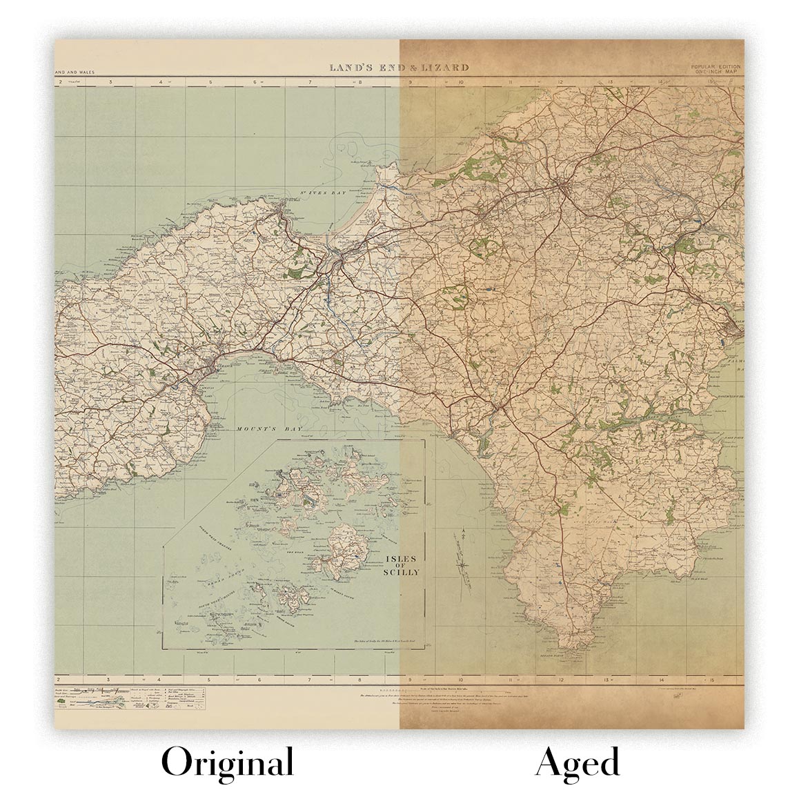
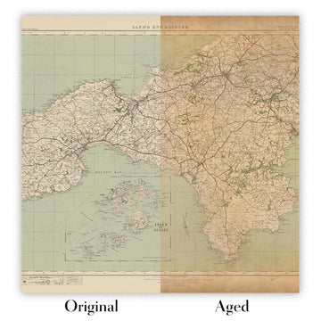
Map ageing
I have been asked hundreds of times over the years by customers if they could buy a map that looks even older.
Well, now you can, by selecting Aged before you add a map to your basket.
All the product photos you see on this page show the map in its Original form. This is what the map looks like today.
If you select Aged, I will age your map by hand, using a special and unique process developed through years of studying old maps, talking to researchers to understand the chemistry of aging paper, and of course... lots of practice!
If you're unsure, stick to the Original colour of the map. If you want something a bit darker and older looking, go for Aged.
If you are not happy with your order for any reason, contact me for a no-quibble refund. Please see our returns and refund policy for more information.
I am very confident you will like your restored map or art print. I have been doing this since 1984. I'm a 5-star Etsy seller. I have sold tens of thousands of maps and art prints and have over 5,000 real 5-star reviews.
I use a unique process to restore maps and artwork that is massively time consuming and labour intensive. Hunting down the original maps and illustrations can take months. I use state of the art and eye-wateringly expensive technology to scan and restore them. As a result, I guarantee my maps and art prints are a cut above the rest - that's why I can offer a no-quibble refund.
Almost all of my maps and art prints look amazing at large sizes (200cm, 6.5ft+) and I can frame and deliver them to you as well, via special oversized courier. Contact me to discuss your specific needs.
Or try searching for something!


