


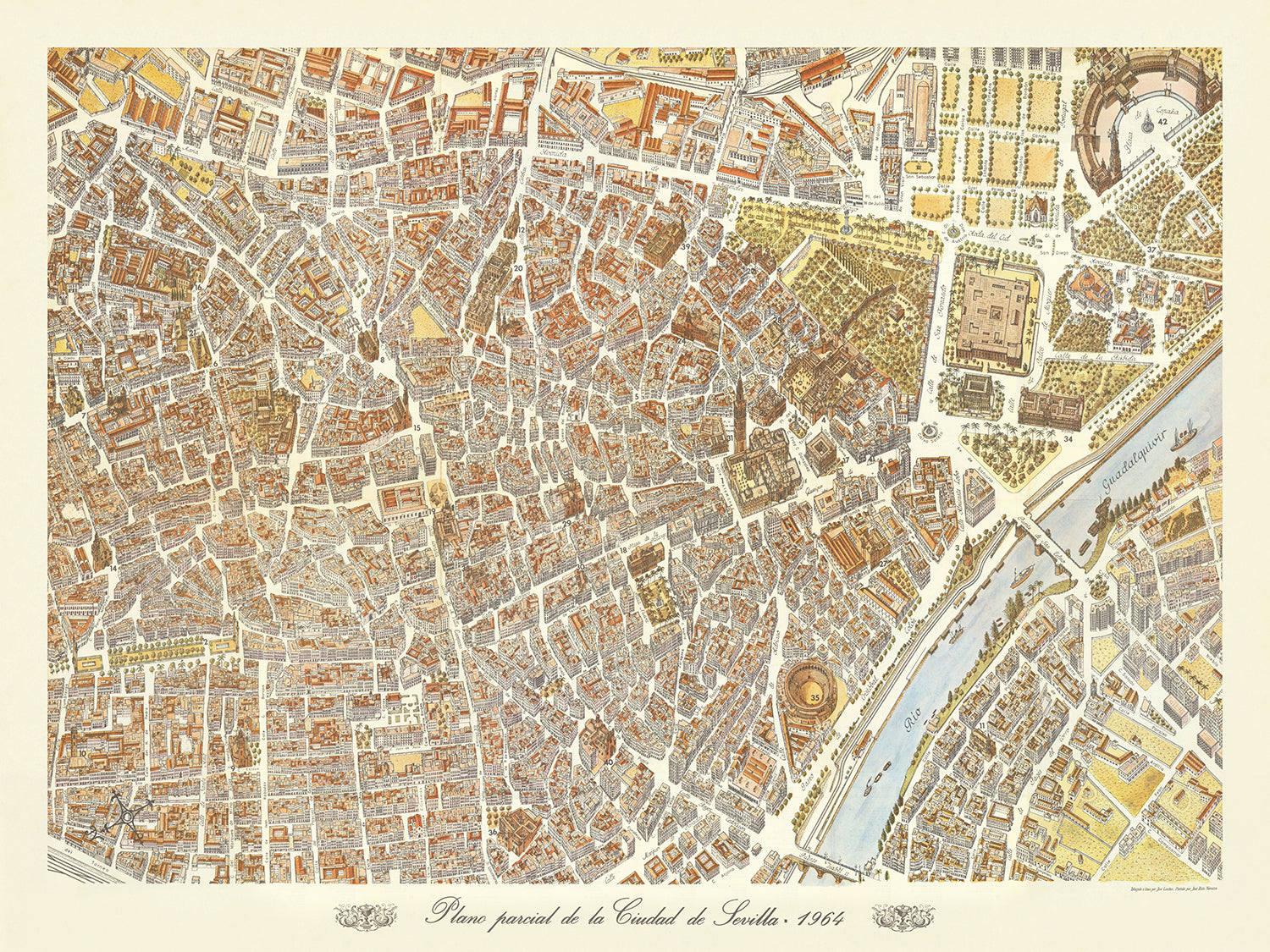
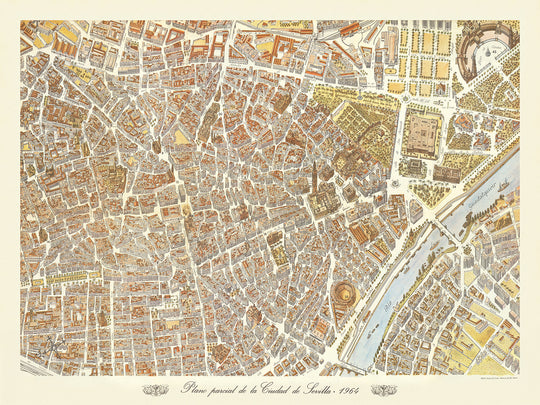
Old Birdseye Map of Seville by Loeches & Navarro, 1964: Cathedral, Alcázar, Bullring, Torre del Oro, Triana.
The "Plano Parcial de la Ciudad de Sevilla," created by Jose Loeches and Jose Ruiz Navarro in 1964, is a stunning birdseye view pictorial map that captures the essence of Sevilla with remarkable detail and artistry. This map, commissioned by the local tourism board, offers a three-dimensional depiction of the city's heart, elegantly illustrating its major buildings, squares, and streets. The map's orientation, with northeast at the top, provides a unique perspective that invites viewers to explore the rich tapestry of Sevilla's urban landscape.
Sevilla, a city steeped in history and culture, is brought to life through this map's meticulous illustrations. The map highlights significant landmarks such as the majestic Catedral de Sevilla, one of the largest Gothic cathedrals in the world, and the Real Alcázar, a royal palace renowned for its stunning Mudejar architecture. The Plaza de Toros de la Maestranza, one of Spain's most famous bullrings, and the iconic Torre del Oro, a historic watchtower on the banks of the Guadalquivir River, are also prominently featured, showcasing the city's architectural splendor.
The map also provides a detailed look at Sevilla's vibrant neighborhoods, each with its own unique charm and history. The historic barrio of Santa Cruz, with its narrow, winding streets and whitewashed houses, is depicted with great care, as is the lively Triana district, known for its flamenco culture and ceramic workshops. These neighborhoods, along with many others, are intricately illustrated, offering a glimpse into the daily life and cultural heritage of Sevilla.
Natural features such as the Guadalquivir River, which has played a crucial role in Sevilla's history as a major port and trade center, are beautifully rendered. The map also highlights the expansive Parque de María Luisa, a lush green space that provides a tranquil retreat from the bustling city. This park, with its picturesque gardens and historic pavilions, is a testament to the city's dedication to preserving its natural beauty amidst urban development.
The creators of this map, Jose Loeches and Jose Ruiz Navarro, are celebrated for their ability to combine artistic flair with cartographic precision. Their work on the "Plano Parcial de la Ciudad de Sevilla" is a prime example of their talent, capturing the essence of the city in a way that is both informative and visually captivating. This map is not just a navigational tool but a piece of art that invites viewers to immerse themselves in the rich history and vibrant culture of Sevilla.
Streets and roads on this map
- Alameda de Hércules
- Avenida de la Constitución
- Calle Adriano
- Calle Alhóndiga
- Calle Alfonso XII
- Calle Amor de Dios
- Calle Arjona
- Calle Bailén
- Calle Betis
- Calle Cuna
- Calle Feria
- Calle Francos
- Calle García de Vinuesa
- Calle Gerona
- Calle Harinas
- Calle Imagen
- Calle Javier Lasso de la Vega
- Calle Laraña
- Calle Lineros
- Calle Mateos Gago
- Calle O'Donnell
- Calle Orfila
- Calle Reyes Católicos
- Calle Sierpes
- Calle Trajano
- Calle Zaragoza
- Paseo de Cristóbal Colón
- Plaza Nueva
- Plaza de San Francisco
- Puente de Triana
Notable Features & Landmarks
- Illustrations:
- Detailed three-dimensional depictions of buildings and structures
- Landmarks:
- Catedral de Sevilla (Seville Cathedral)
- Plaza de Toros de la Maestranza (Bullring of the Royal Cavalry of Seville)
- Torre del Oro (Tower of Gold)
- Real Alcázar de Sevilla (Royal Alcázar of Seville)
- Neighbourhoods:
- Triana
- Santa Cruz
- Large parks:
- Parque de María Luisa
- Other notable features:
- Guadalquivir River
- Various bridges crossing the river
Historical and design context
- Name of the map: Plano Parcial de la Ciudad de Sevilla
- Description:
- Interesting birdseye view style pictorial map of Sevilla, published for the local tourism board.
- On the front, an illustrated look at the city center is shown, with an elegant depiction of major buildings, squares, streets, etc. in three dimensions.
- The map is oriented with northeast at the top.
- Date created: 1964
- Mapmakers/Publishers: Jose Loeches & Jose Ruiz Navarro
- Context about the mapmakers: Known for creating detailed and artistic maps, often for tourism purposes.
- Themes shown on the map:
- City center of Sevilla
- Major buildings, squares, and streets
- Three-dimensional depiction of structures
- Countries and regions shown on the map:
- Spain
- City of Sevilla in the region of Andalusia
- Design/Style:
- Birdseye view style
- Pictorial and illustrative
- Three-dimensional representation of buildings and landmarks
- Historical significance:
- Provides a detailed visual representation of Sevilla in the mid-20th century
- Useful for historical comparison with modern maps
- Reflects the artistic map-making style of the era
Please double check the images to make sure that a specific town or place is shown on this map. You can also get in touch and ask us to check the map for you.
This map looks great at every size, but I always recommend going for a larger size if you have space. That way you can easily make out all of the details.
This map looks amazing at sizes all the way up to 100in (250cm). If you are looking for a larger map, please get in touch.
Please note: the labels on this map are hard to read if you order a map that is 16in (40cm) or smaller. The map is still very attractive, but if you would like to read the map easily, please buy a larger size.
The model in the listing images is holding the 18x24in (45x60cm) version of this map.
The fifth listing image shows an example of my map personalisation service.
If you’re looking for something slightly different, check out my collection of the best old maps to see if something else catches your eye.
Please contact me to check if a certain location, landmark or feature is shown on this map.
This would make a wonderful birthday, Christmas, Father's Day, work leaving, anniversary or housewarming gift for someone from the areas covered by this map.
This map is available as a giclée print on acid free archival matte paper, or you can buy it framed. The frame is a nice, simple black frame that suits most aesthetics. Please get in touch if you'd like a different frame colour or material. My frames are glazed with super-clear museum-grade acrylic (perspex/acrylite), which is significantly less reflective than glass, safer, and will always arrive in perfect condition.
This map is also available as a float framed canvas, sometimes known as a shadow gap framed canvas or canvas floater. The map is printed on artist's cotton canvas and then stretched over a handmade box frame. We then "float" the canvas inside a wooden frame, which is available in a range of colours (black, dark brown, oak, antique gold and white). This is a wonderful way to present a map without glazing in front. See some examples of float framed canvas maps and explore the differences between my different finishes.
For something truly unique, this map is also available in "Unique 3D", our trademarked process that dramatically transforms the map so that it has a wonderful sense of depth. We combine the original map with detailed topography and elevation data, so that mountains and the terrain really "pop". For more info and examples of 3D maps, check my Unique 3D page.
-
Handmade in the USA
-
FREE worldwide delivery in 2-3 days ⓘ
Free delivery in 2-3 days
Your map should be delivered in 2-3 working days with free delivery, worldwide.
We make maps by hand locally in 23 countries, including the USA
. If you're buying a gift for someone in another country, we will make the map locally to them.You will never pay import tax or customs duty.
Express delivery is available at checkout which can reduce the delivery time to 1-2 days.
Please note that personalised maps, and larger framed maps, can take longer to produce and deliver.
If you need your order to arrive by a certain date, contact me and we can discuss your options.
-
90 day money back guarantee
ⓘ
90 days to return and refund
Products can be returned within 90 days for a full refund, or exchange for another product.
For personalised or custom made items, we may offer you store credit or a non-expiring gift card, as we cannot resell personalised orders.
If you have any questions, get in touch. For more information, see our full returns & exchanges policy.
My maps are rare, museum-grade, restored old maps sourced from libraries, auction houses and private collections across the globe.
Framing & free personalisation available
1. Select your size
➢ Pick the closest size (above)
➢ Provide the exact size in millimetres
➢ Add to bag and checkout as normal
Click here to order a custom size.
2. Frame & personalize your map
Make your map unique with framing, hand-drawn customisation, vintage ageing, pop art text, unique 3D styling and more➢ Rolled up and delivered in a tube
➢ Free
Free custom map sizing
At The Unique Maps Co., every order is processed and made by hand. There is no mass production and every map is custom made to order.
This means that I can tailor your map so that it perfectly fits a space on your wall, or a frame that you already own.
To order a custom sized map: select a larger size than what you need, click "click here to order a custom size, provide your custom size in millimetres, add it to your bag, and checkout as normal.
For example, if you need a custom sized 45x65cm map, you would add the 50x70cm map to your bag.

Contact me if you need any assistance.
250 Characters remaining
Personalised maps
Personalisation can be anything: a message, route, an illustration of your pet dog. See lots more examples.
Move the slider to see a personalised Irish Whisky distillery map.
Here's a romantic one that I hand illustrated on a map of Singapore.
And here's a really cool one: adding a Scottish clan and motto!
Unique 3D™
Your map will undergo a beautifully dramatic transformation with our trademarked "Unique 3D" process, adding a wonderful sense of depth to your map. Here's a photo review from one very happy customer...

Every Unique 3D order is processed by hand to ensure we perfectly capture the nuances of the colour, detail and topography of your map.
Move the slider to see an example of an old map in its original form, and after our Unique 3D process has been applied.
A close-up of Blaeu's world map, 1662
The complete Blaeu world map
Northumberland, 1901
And here's two more beautiful examples of Unique 3D in action, including Unique 3D + Aged.
Lebanon, 1862 (Unique 3D + Aged)
Arabian Peninsula, 1893 (Unique 3D + Aged)
Holy Land, 1566 (Unique 3D + Aged)
Please note that your map will not actually be 3D. It will be flat. This means it can still be framed and hung normally.
Aged maps
If you're looking for an older looking map, select the "Aged" tone for your map. I will use a secret process, developed over two decades, to make the map look older.
If you want a "light ageing" or "dark ageing", please add it to your order notes on the checkout screen. Every order is made by hand, so I can adjust the ageing to exactly what you need.
Move the sliders to compare the Original and Aged tones. See lots more examples.
Here's an Original/Aged example of the Anglo Saxon Heptarchy.
And one more of the Roman Empire.
Screenprint Style Word Art
Make your map really POP with this unique customisation. I will add some large, screenprint style words over the top of your map.
Some maps can be visually quite dull from a distance, but fascinating close-up. Adding my pop art text can really increase the visual appeal of a map and turn it into a statement piece.
Many of my customers like to choose words that have special significance and then gift it to a friend or loved one.
You can pick any text you like, but generally shorter phrases are more impactful. You can also choose any colour!
More examples


Gift message & custom finish

If you want to add a gift message, or a finish (jigsaw, aluminium board, etc.) that is not available here, please request it in the "order note" when you check out.
Every order is custom made, so if you need the size adjusted slightly, or printed on an unusual material, just let us know. We've done thousands of custom orders over the years, so there's (almost) nothing we can't manage.
You can also contact us before you order, if you prefer!

- Handmade locally. No import duty or tax
- FREE Delivery. Arrives in 2-3 days
- Love it or your money back
- Questions? WhatsApp me any time
Own a piece of history
5,000+ 5 star reviews
The "Plano Parcial de la Ciudad de Sevilla," created by Jose Loeches and Jose Ruiz Navarro in 1964, is a stunning birdseye view pictorial map that captures the essence of Sevilla with remarkable detail and artistry. This map, commissioned by the local tourism board, offers a three-dimensional depiction of the city's heart, elegantly illustrating its major buildings, squares, and streets. The map's orientation, with northeast at the top, provides a unique perspective that invites viewers to explore the rich tapestry of Sevilla's urban landscape.
Sevilla, a city steeped in history and culture, is brought to life through this map's meticulous illustrations. The map highlights significant landmarks such as the majestic Catedral de Sevilla, one of the largest Gothic cathedrals in the world, and the Real Alcázar, a royal palace renowned for its stunning Mudejar architecture. The Plaza de Toros de la Maestranza, one of Spain's most famous bullrings, and the iconic Torre del Oro, a historic watchtower on the banks of the Guadalquivir River, are also prominently featured, showcasing the city's architectural splendor.
The map also provides a detailed look at Sevilla's vibrant neighborhoods, each with its own unique charm and history. The historic barrio of Santa Cruz, with its narrow, winding streets and whitewashed houses, is depicted with great care, as is the lively Triana district, known for its flamenco culture and ceramic workshops. These neighborhoods, along with many others, are intricately illustrated, offering a glimpse into the daily life and cultural heritage of Sevilla.
Natural features such as the Guadalquivir River, which has played a crucial role in Sevilla's history as a major port and trade center, are beautifully rendered. The map also highlights the expansive Parque de María Luisa, a lush green space that provides a tranquil retreat from the bustling city. This park, with its picturesque gardens and historic pavilions, is a testament to the city's dedication to preserving its natural beauty amidst urban development.
The creators of this map, Jose Loeches and Jose Ruiz Navarro, are celebrated for their ability to combine artistic flair with cartographic precision. Their work on the "Plano Parcial de la Ciudad de Sevilla" is a prime example of their talent, capturing the essence of the city in a way that is both informative and visually captivating. This map is not just a navigational tool but a piece of art that invites viewers to immerse themselves in the rich history and vibrant culture of Sevilla.
Streets and roads on this map
- Alameda de Hércules
- Avenida de la Constitución
- Calle Adriano
- Calle Alhóndiga
- Calle Alfonso XII
- Calle Amor de Dios
- Calle Arjona
- Calle Bailén
- Calle Betis
- Calle Cuna
- Calle Feria
- Calle Francos
- Calle García de Vinuesa
- Calle Gerona
- Calle Harinas
- Calle Imagen
- Calle Javier Lasso de la Vega
- Calle Laraña
- Calle Lineros
- Calle Mateos Gago
- Calle O'Donnell
- Calle Orfila
- Calle Reyes Católicos
- Calle Sierpes
- Calle Trajano
- Calle Zaragoza
- Paseo de Cristóbal Colón
- Plaza Nueva
- Plaza de San Francisco
- Puente de Triana
Notable Features & Landmarks
- Illustrations:
- Detailed three-dimensional depictions of buildings and structures
- Landmarks:
- Catedral de Sevilla (Seville Cathedral)
- Plaza de Toros de la Maestranza (Bullring of the Royal Cavalry of Seville)
- Torre del Oro (Tower of Gold)
- Real Alcázar de Sevilla (Royal Alcázar of Seville)
- Neighbourhoods:
- Triana
- Santa Cruz
- Large parks:
- Parque de María Luisa
- Other notable features:
- Guadalquivir River
- Various bridges crossing the river
Historical and design context
- Name of the map: Plano Parcial de la Ciudad de Sevilla
- Description:
- Interesting birdseye view style pictorial map of Sevilla, published for the local tourism board.
- On the front, an illustrated look at the city center is shown, with an elegant depiction of major buildings, squares, streets, etc. in three dimensions.
- The map is oriented with northeast at the top.
- Date created: 1964
- Mapmakers/Publishers: Jose Loeches & Jose Ruiz Navarro
- Context about the mapmakers: Known for creating detailed and artistic maps, often for tourism purposes.
- Themes shown on the map:
- City center of Sevilla
- Major buildings, squares, and streets
- Three-dimensional depiction of structures
- Countries and regions shown on the map:
- Spain
- City of Sevilla in the region of Andalusia
- Design/Style:
- Birdseye view style
- Pictorial and illustrative
- Three-dimensional representation of buildings and landmarks
- Historical significance:
- Provides a detailed visual representation of Sevilla in the mid-20th century
- Useful for historical comparison with modern maps
- Reflects the artistic map-making style of the era
Please double check the images to make sure that a specific town or place is shown on this map. You can also get in touch and ask us to check the map for you.
This map looks great at every size, but I always recommend going for a larger size if you have space. That way you can easily make out all of the details.
This map looks amazing at sizes all the way up to 100in (250cm). If you are looking for a larger map, please get in touch.
Please note: the labels on this map are hard to read if you order a map that is 16in (40cm) or smaller. The map is still very attractive, but if you would like to read the map easily, please buy a larger size.
The model in the listing images is holding the 18x24in (45x60cm) version of this map.
The fifth listing image shows an example of my map personalisation service.
If you’re looking for something slightly different, check out my collection of the best old maps to see if something else catches your eye.
Please contact me to check if a certain location, landmark or feature is shown on this map.
This would make a wonderful birthday, Christmas, Father's Day, work leaving, anniversary or housewarming gift for someone from the areas covered by this map.
This map is available as a giclée print on acid free archival matte paper, or you can buy it framed. The frame is a nice, simple black frame that suits most aesthetics. Please get in touch if you'd like a different frame colour or material. My frames are glazed with super-clear museum-grade acrylic (perspex/acrylite), which is significantly less reflective than glass, safer, and will always arrive in perfect condition.
This map is also available as a float framed canvas, sometimes known as a shadow gap framed canvas or canvas floater. The map is printed on artist's cotton canvas and then stretched over a handmade box frame. We then "float" the canvas inside a wooden frame, which is available in a range of colours (black, dark brown, oak, antique gold and white). This is a wonderful way to present a map without glazing in front. See some examples of float framed canvas maps and explore the differences between my different finishes.
For something truly unique, this map is also available in "Unique 3D", our trademarked process that dramatically transforms the map so that it has a wonderful sense of depth. We combine the original map with detailed topography and elevation data, so that mountains and the terrain really "pop". For more info and examples of 3D maps, check my Unique 3D page.
For most orders, delivery time is about 3 working days. Personalised and customised products take longer, as I have to do the personalisation and send it to you for approval, which usually takes 1 or 2 days.
Please note that very large framed orders usually take longer to make and deliver.
If you need your order to arrive by a certain date, please contact me before you order so that we can find the best way of making sure you get your order in time.
I print and frame maps and artwork in 23 countries around the world. This means your order will be made locally, which cuts down on delivery time and ensures that it won't be damaged during delivery. You'll never pay customs or import duty, and we'll put less CO2 into the air.
All of my maps and art prints are well packaged and sent in a rugged tube if unframed, or surrounded by foam if framed.
I try to send out all orders within 1 or 2 days of receiving your order, though some products (like face masks, mugs and tote bags) can take longer to make.
If you select Express Delivery at checkout your order we will prioritise your order and send it out by 1-day courier (Fedex, DHL, UPS, Parcelforce).
Next Day delivery is also available in some countries (US, UK, Singapore, UAE) but please try to order early in the day so that we can get it sent out on time.
My standard frame is a gallery style black ash hardwood frame. It is simple and quite modern looking. My standard frame is around 20mm (0.8in) wide.
I use super-clear acrylic (perspex/acrylite) for the frame glass. It's lighter and safer than glass - and it looks better, as the reflectivity is lower.
Six standard frame colours are available for free (black, dark brown, dark grey, oak, white and antique gold). Custom framing and mounting/matting is available if you're looking for something else.
Most maps, art and illustrations are also available as a framed canvas. We use matte (not shiny) cotton canvas, stretch it over a sustainably sourced box wood frame, and then 'float' the piece within a wood frame. The end result is quite beautiful, and there's no glazing to get in the way.
All frames are provided "ready to hang", with either a string or brackets on the back. Very large frames will have heavy duty hanging plates and/or a mounting baton. If you have any questions, please get in touch.
See some examples of my framed maps and framed canvas maps.
Alternatively, I can also supply old maps and artwork on canvas, foam board, cotton rag and other materials.
If you want to frame your map or artwork yourself, please read my size guide first.
My maps are extremely high quality reproductions of original maps.
I source original, rare maps from libraries, auction houses and private collections around the world, restore them at my London workshop, and then use specialist giclée inks and printers to create beautiful maps that look even better than the original.
My maps are printed on acid-free archival matte (not glossy) paper that feels very high quality and almost like card. In technical terms the paper weight/thickness is 10mil/200gsm. It's perfect for framing.
I print with Epson ultrachrome giclée UV fade resistant pigment inks - some of the best inks you can find.
I can also make maps on canvas, cotton rag and other exotic materials.
Learn more about The Unique Maps Co.
Map personalisation
If you're looking for the perfect anniversary or housewarming gift, I can personalise your map to make it truly unique. For example, I can add a short message, or highlight an important location, or add your family's coat of arms.
The options are almost infinite. Please see my map personalisation page for some wonderful examples of what's possible.
To order a personalised map, select "personalise your map" before adding it to your basket.
Get in touch if you're looking for more complex customisations and personalisations.
Map ageing
I have been asked hundreds of times over the years by customers if they could buy a map that looks even older.
Well, now you can, by selecting Aged before you add a map to your basket.
All the product photos you see on this page show the map in its Original form. This is what the map looks like today.
If you select Aged, I will age your map by hand, using a special and unique process developed through years of studying old maps, talking to researchers to understand the chemistry of aging paper, and of course... lots of practice!
If you're unsure, stick to the Original colour of the map. If you want something a bit darker and older looking, go for Aged.
If you are not happy with your order for any reason, contact me for a no-quibble refund. Please see our returns and refund policy for more information.
I am very confident you will like your restored map or art print. I have been doing this since 1984. I'm a 5-star Etsy seller. I have sold tens of thousands of maps and art prints and have over 5,000 real 5-star reviews.
I use a unique process to restore maps and artwork that is massively time consuming and labour intensive. Hunting down the original maps and illustrations can take months. I use state of the art and eye-wateringly expensive technology to scan and restore them. As a result, I guarantee my maps and art prints are a cut above the rest - that's why I can offer a no-quibble refund.
Almost all of my maps and art prints look amazing at large sizes (200cm, 6.5ft+) and I can frame and deliver them to you as well, via special oversized courier. Contact me to discuss your specific needs.
Or try searching for something!
This service is currently unavailable,
sorry for the inconvenience.
Pair it with a frame
Frame options are for visualization purposes only.
FRAME STYLE
MATTING SIZE
BUILDING YOUR EXPERIENCE
powered by Blankwall
Take a few steps back and let your camera see more of the scene.
powered by Blankwall
Was this experience helpful?
The "Plano Parcial de la Ciudad de Sevilla," created by Jose Loeches and Jose Ruiz Navarro in 1964, is a stunning birdseye view pictorial map that captures the essence of Sevilla with remarkable detail and artistry. This map, commissioned by the local tourism board, offers a three-dimensional depiction of the city's heart, elegantly illustrating its major buildings, squares, and streets. The map's orientation, with northeast at the top, provides a unique perspective that invites viewers to explore the rich tapestry of Sevilla's urban landscape.
Sevilla, a city steeped in history and culture, is brought to life through this map's meticulous illustrations. The map highlights significant landmarks such as the majestic Catedral de Sevilla, one of the largest Gothic cathedrals in the world, and the Real Alcázar, a royal palace renowned for its stunning Mudejar architecture. The Plaza de Toros de la Maestranza, one of Spain's most famous bullrings, and the iconic Torre del Oro, a historic watchtower on the banks of the Guadalquivir River, are also prominently featured, showcasing the city's architectural splendor.
The map also provides a detailed look at Sevilla's vibrant neighborhoods, each with its own unique charm and history. The historic barrio of Santa Cruz, with its narrow, winding streets and whitewashed houses, is depicted with great care, as is the lively Triana district, known for its flamenco culture and ceramic workshops. These neighborhoods, along with many others, are intricately illustrated, offering a glimpse into the daily life and cultural heritage of Sevilla.
Natural features such as the Guadalquivir River, which has played a crucial role in Sevilla's history as a major port and trade center, are beautifully rendered. The map also highlights the expansive Parque de María Luisa, a lush green space that provides a tranquil retreat from the bustling city. This park, with its picturesque gardens and historic pavilions, is a testament to the city's dedication to preserving its natural beauty amidst urban development.
The creators of this map, Jose Loeches and Jose Ruiz Navarro, are celebrated for their ability to combine artistic flair with cartographic precision. Their work on the "Plano Parcial de la Ciudad de Sevilla" is a prime example of their talent, capturing the essence of the city in a way that is both informative and visually captivating. This map is not just a navigational tool but a piece of art that invites viewers to immerse themselves in the rich history and vibrant culture of Sevilla.
Streets and roads on this map
- Alameda de Hércules
- Avenida de la Constitución
- Calle Adriano
- Calle Alhóndiga
- Calle Alfonso XII
- Calle Amor de Dios
- Calle Arjona
- Calle Bailén
- Calle Betis
- Calle Cuna
- Calle Feria
- Calle Francos
- Calle García de Vinuesa
- Calle Gerona
- Calle Harinas
- Calle Imagen
- Calle Javier Lasso de la Vega
- Calle Laraña
- Calle Lineros
- Calle Mateos Gago
- Calle O'Donnell
- Calle Orfila
- Calle Reyes Católicos
- Calle Sierpes
- Calle Trajano
- Calle Zaragoza
- Paseo de Cristóbal Colón
- Plaza Nueva
- Plaza de San Francisco
- Puente de Triana
Notable Features & Landmarks
- Illustrations:
- Detailed three-dimensional depictions of buildings and structures
- Landmarks:
- Catedral de Sevilla (Seville Cathedral)
- Plaza de Toros de la Maestranza (Bullring of the Royal Cavalry of Seville)
- Torre del Oro (Tower of Gold)
- Real Alcázar de Sevilla (Royal Alcázar of Seville)
- Neighbourhoods:
- Triana
- Santa Cruz
- Large parks:
- Parque de María Luisa
- Other notable features:
- Guadalquivir River
- Various bridges crossing the river
Historical and design context
- Name of the map: Plano Parcial de la Ciudad de Sevilla
- Description:
- Interesting birdseye view style pictorial map of Sevilla, published for the local tourism board.
- On the front, an illustrated look at the city center is shown, with an elegant depiction of major buildings, squares, streets, etc. in three dimensions.
- The map is oriented with northeast at the top.
- Date created: 1964
- Mapmakers/Publishers: Jose Loeches & Jose Ruiz Navarro
- Context about the mapmakers: Known for creating detailed and artistic maps, often for tourism purposes.
- Themes shown on the map:
- City center of Sevilla
- Major buildings, squares, and streets
- Three-dimensional depiction of structures
- Countries and regions shown on the map:
- Spain
- City of Sevilla in the region of Andalusia
- Design/Style:
- Birdseye view style
- Pictorial and illustrative
- Three-dimensional representation of buildings and landmarks
- Historical significance:
- Provides a detailed visual representation of Sevilla in the mid-20th century
- Useful for historical comparison with modern maps
- Reflects the artistic map-making style of the era
Please double check the images to make sure that a specific town or place is shown on this map. You can also get in touch and ask us to check the map for you.
This map looks great at every size, but I always recommend going for a larger size if you have space. That way you can easily make out all of the details.
This map looks amazing at sizes all the way up to 100in (250cm). If you are looking for a larger map, please get in touch.
Please note: the labels on this map are hard to read if you order a map that is 16in (40cm) or smaller. The map is still very attractive, but if you would like to read the map easily, please buy a larger size.
The model in the listing images is holding the 18x24in (45x60cm) version of this map.
The fifth listing image shows an example of my map personalisation service.
If you’re looking for something slightly different, check out my collection of the best old maps to see if something else catches your eye.
Please contact me to check if a certain location, landmark or feature is shown on this map.
This would make a wonderful birthday, Christmas, Father's Day, work leaving, anniversary or housewarming gift for someone from the areas covered by this map.
This map is available as a giclée print on acid free archival matte paper, or you can buy it framed. The frame is a nice, simple black frame that suits most aesthetics. Please get in touch if you'd like a different frame colour or material. My frames are glazed with super-clear museum-grade acrylic (perspex/acrylite), which is significantly less reflective than glass, safer, and will always arrive in perfect condition.

