


Old Pictorial Map of Poitou-Charentes by Liozu, 1951: La Rochelle, Poitiers, Angoulême, Marais Poitevin
Buy 2, Get 1 More Free
If you add 2 items to your bag, you can add a third product for free. The discount is automatic - no code required.
This is equivalent to 33% off, which will be the largest discount available on my shop this year.
This works for all maps and artwork. You can order 3 of the same thing, or 3 different things.
Custom maps are excluded, as they're too time consuming to make and we'd prefer to take our time rather than rush through a lot of orders.
Contact me if you have any questions.
-
![]() Handmade in the USA
Handmade in the USA

-
FREE worldwide delivery in 2-3 days ⓘ
Free delivery in 2-3 days
Your map should be delivered in 2-3 working days with free delivery, worldwide.
We make maps by hand locally in 23 countries, including the USA
![]() . If you're buying a gift for someone in another country, we will make the map locally to them.
. If you're buying a gift for someone in another country, we will make the map locally to them.You will never pay import tax or customs duty.
Express delivery is available at checkout which can reduce the delivery time to 1-2 days.
Please note that personalised maps, and larger framed maps, can take longer to produce and deliver.
If you need your order to arrive by a certain date, contact me and we can discuss your options.
-
Complimentary gifting & design advice
ⓘ
Complimentary gifting & design advice
Available almost 24/7 on WhatsApp and email — we usually reply within minutes. We can help you:
- Choose a perfectly personalised gift
- Send a digital gift preview to the recipient
- Pick the ideal size for your wall
- Select the right finish and frame
Quick, friendly advice so you can order with confidence.
For last minute gifts, consider buying a digital gift card. We have over 5,000 maps and art prints to choose from.
-
90-day returns & 5-year guarantee
ⓘ
90-day returns & 5-year guarantee
Products can be returned within 90 days for a full refund, or exchange for another product.
We are also proud to offer a 5-year quality guarantee on our maps and art, covering defects in materials or workmanship under normal use.
For personalised and custom made items, we may offer you store credit or a non-expiring gift card, as we cannot resell personalised orders.
If you have any questions, get in touch. For more information, see our full returns & exchanges policy.

This is a museum-grade archival print from the original 1951 map — restored in our workshop and made to order on 220gsm archival matte paper or 400gsm artist's cotton canvas with pigment inks.
Professional framing & free personalisation available
1. Choose a size
2. Frame & personalize your map
Make your map unique with framing, hand-drawn customisation, vintage ageing, pop art text, unique 3D styling and more.


Gift message & custom finish

If you want to add a gift message, or a finish (jigsaw, aluminium board, etc.) that is not available here, please request it in the "order note" when you check out.
Every order is custom made, so if you need the size adjusted slightly, or printed on an unusual material, just let us know. We've done thousands of custom orders over the years, so there's (almost) nothing we can't manage.
You can also contact us before you order, if you prefer!

- Handmade locally. No import duty or tax
- FREE worldwide delivery
- 90-day returns & 5-year product guarantee
- Questions? WhatsApp me any time
Own a piece of history
7,000+ 5 star reviews


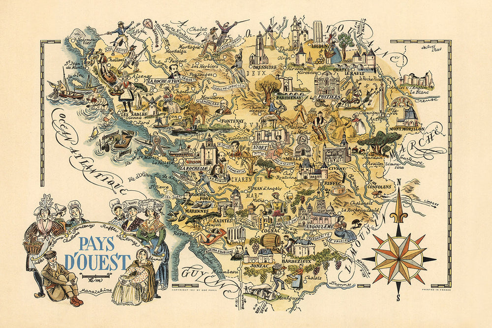
Step into the captivating world of mid-20th century cartography with the "Pays d'Ouest" map, meticulously crafted by the esteemed Jacques Liozu in 1951. This color pictorial map elegantly captures the essence of the western regions of France, particularly Poitou-Charentes and the southern part of Pays de la Loire. Liozu's masterful artistry brings to life the rich tapestry of this historical region, offering a visual feast that is both informative and aesthetically pleasing. The decorative compass rose, a hallmark of Liozu's work, not only serves as a navigational aid but also adds a touch of artistic flair, making this map a true collector's piece.
Jacques Liozu, renowned for his detailed and artistically rich maps, has imbued the "Pays d'Ouest" with a wealth of historical and cultural elements. The map is a treasure trove of historical landmarks, from the imposing Château de Saumur to the storied Château de Chinon. Each landmark is intricately illustrated, providing a glimpse into the architectural grandeur and historical significance of these sites. Liozu's work transcends mere cartography, offering a narrative that connects the viewer with the rich history and cultural heritage of the region.
The "Pays d'Ouest" map is not just a geographical representation; it is a vibrant tableau of the region's natural and man-made wonders. The map showcases national parks like the Parc Naturel Régional du Marais Poitevin, highlighting the region's commitment to preserving its natural beauty. Rivers, mountains, and other natural phenomena are depicted with a pictorial relief, adding depth and dimension to the map. This artistic approach allows viewers to appreciate the diverse landscapes that define the western regions of France.
Liozu's map also serves as a historical document, capturing significant events that have shaped the region. The Battle of Poitiers in 732 and the Siege of La Rochelle in 1627-1628 are among the notable historical events illustrated on the map. These depictions provide context and depth, enriching the viewer's understanding of the region's tumultuous past. By intertwining historical events with geographical features, Liozu offers a comprehensive and engaging narrative that appeals to both history enthusiasts and casual viewers alike.
The cities and towns depicted on the "Pays d'Ouest" map are a testament to the region's vibrant urban and rural life. From the bustling city of Nantes to the picturesque town of La Rochelle, each settlement is meticulously illustrated, reflecting its unique character and significance. The map also highlights smaller towns like Fontenay-le-Comte and Challans, ensuring that no detail is overlooked. This comprehensive approach makes the "Pays d'Ouest" map not only a beautiful work of art but also an invaluable resource for anyone interested in the geography and history of western France.
Cities and towns on this map
- Pays de la Loire:
- La Roche-sur-Yon
- Cholet
- Les Sables-d'Olonne
- Fontenay-le-Comte
- Montaigu
-
Les Herbiers
-
Poitou-Charentes:
- Poitiers
- La Rochelle
- Niort
- Angoulême
- Châtellerault
- Rochefort
- Saintes
- Royan
- Cognac
- Thouars
- Parthenay
- Ruffec
- Montmorillon
- Melle
- Civray
- Confolens
- Barbezieux
- Jonzac
Notable Features & Landmarks
- Historic landmarks:
- Château de Saumur
- Château de Chinon
- Château de Montsoreau
- Château de Brézé
- Château de Thouars
- Château d'Angers
- Château de Nantes
- Château de Clisson
- Château de Tiffauges
- Château de La Rochefoucauld
- Château de Javarzay
- Château de la Roche Courbon
-
Château de Crazannes
-
National and major parks:
- Parc Naturel Régional du Marais Poitevin
-
Historical events:
- Battle of Poitiers (732)
- Siege of La Rochelle (1627-1628)
Historical and design context
- Name of the map: Pays d'Ouest
- Date created: 1951
- Mapmaker/Publisher: Jacques Liozu
- Color pictorial map: The map is colorful and illustrated, providing a visual representation of the western regions.
- Regions depicted: Includes some of Pays de la Loire, a region in France, and Poitou-Charentes.
- Decorative compass rose: The map features an ornate compass rose, adding to its decorative appeal.
- Relief shown pictorially: The map uses illustrations to depict the terrain and landscape features.
- Themes and topics:
- Historical and cultural depiction: The map includes various historical landmarks, cultural icons, and notable events.
- Pictorial elements: Illustrations of people, animals, and activities provide insights into the region's culture and history.
- Design and style:
- Artistic and thematic elements: The map is rich in artistic detail, combining functionality with visual storytelling.
- Historical significance: The map provides a glimpse into the cultural and historical landscape of the region in the mid-20th century.
Please double check the images to make sure that a specific town or place is shown on this map. You can also get in touch and ask us to check the map for you.
This map looks great at every size, but I always recommend going for a larger size if you have space. That way you can easily make out all of the details.
This map looks amazing at sizes all the way up to 70in (180cm). If you are looking for a larger map, please get in touch.
The model in the listing images is holding the 24x36in (60x90cm) version of this map.
The fifth listing image shows an example of my map personalisation service.
If you’re looking for something slightly different, check out my collection of the best old maps to see if something else catches your eye.
Please contact me to check if a certain location, landmark or feature is shown on this map.
This would make a wonderful birthday, Christmas, Father's Day, work leaving, anniversary or housewarming gift for someone from the areas covered by this map.
This map is available as a giclée print on acid free archival matte paper, or you can buy it framed. The frame is a nice, simple black frame that suits most aesthetics. Please get in touch if you'd like a different frame colour or material. My frames are glazed with super-clear museum-grade acrylic (perspex/acrylite), which is significantly less reflective than glass, safer, and will always arrive in perfect condition.
This map is also available as a float framed canvas, sometimes known as a shadow gap framed canvas or canvas floater. The map is printed on artist's cotton canvas and then stretched over a handmade box frame. We then "float" the canvas inside a wooden frame, which is available in a range of colours (black, dark brown, oak, antique gold and white). This is a wonderful way to present a map without glazing in front. See some examples of float framed canvas maps and explore the differences between my different finishes.
For something truly unique, this map is also available in "Unique 3D", our trademarked process that dramatically transforms the map so that it has a wonderful sense of depth. We combine the original map with detailed topography and elevation data, so that mountains and the terrain really "pop". For more info and examples of 3D maps, check my Unique 3D page.
For most orders, delivery time is about 3 working days. Personalised and customised products take longer, as I have to do the personalisation and send it to you for approval, which usually takes 1 or 2 days.
Please note that very large framed orders usually take longer to make and deliver.
If you need your order to arrive by a certain date, please contact me before you order so that we can find the best way of making sure you get your order in time.
I print and frame maps and artwork in 23 countries around the world. This means your order will be made locally, which cuts down on delivery time and ensures that it won't be damaged during delivery. You'll never pay customs or import duty, and we'll put less CO2 into the air.
All of my maps and art prints are well packaged and sent in a rugged tube if unframed, or surrounded by foam if framed.
I try to send out all orders within 1 or 2 days of receiving your order, though some products (like face masks, mugs and tote bags) can take longer to make.
If you select Express Delivery at checkout your order we will prioritise your order and send it out by 1-day courier (Fedex, DHL, UPS, Parcelforce).
Next Day delivery is also available in some countries (US, UK, Singapore, UAE) but please try to order early in the day so that we can get it sent out on time.
My standard frame is a gallery style black ash hardwood frame. It is simple and quite modern looking. My standard frame is around 20mm (0.8in) wide.
I use super-clear acrylic (perspex/acrylite) for the frame glass. It's lighter and safer than glass - and it looks better, as the reflectivity is lower.
Six standard frame colours are available for free (black, dark brown, dark grey, oak, white and antique gold). Custom framing and mounting/matting is available if you're looking for something else.
Most maps, art and illustrations are also available as a framed canvas. We use matte (not shiny) cotton canvas, stretch it over a sustainably sourced box wood frame, and then 'float' the piece within a wood frame. The end result is quite beautiful, and there's no glazing to get in the way.
All frames are provided "ready to hang", with either a string or brackets on the back. Very large frames will have heavy duty hanging plates and/or a mounting baton. If you have any questions, please get in touch.
See some examples of my framed maps and framed canvas maps.
Alternatively, I can also supply old maps and artwork on canvas, foam board, cotton rag and other materials.
If you want to frame your map or artwork yourself, please read my size guide first.
My maps are extremely high quality reproductions of original maps.
I source original, rare maps from libraries, auction houses and private collections around the world, restore them at my London workshop, and then use specialist giclée inks and printers to create beautiful maps that look even better than the original.
My maps are printed on acid-free archival matte (not glossy) paper that feels very high quality and almost like card. In technical terms the paper weight/thickness is 10mil/200gsm. It's perfect for framing.
I print with Epson ultrachrome giclée UV fade resistant pigment inks - some of the best inks you can find.
I can also make maps on canvas, cotton rag and other exotic materials.
Learn more about The Unique Maps Co.
Map personalisation
If you're looking for the perfect anniversary or housewarming gift, I can personalise your map to make it truly unique. For example, I can add a short message, or highlight an important location, or add your family's coat of arms.
The options are almost infinite. Please see my map personalisation page for some wonderful examples of what's possible.
To order a personalised map, select "personalise your map" before adding it to your basket.
Get in touch if you're looking for more complex customisations and personalisations.
Map ageing
I have been asked hundreds of times over the years by customers if they could buy a map that looks even older.
Well, now you can, by selecting Aged before you add a map to your basket.
All the product photos you see on this page show the map in its Original form. This is what the map looks like today.
If you select Aged, I will age your map by hand, using a special and unique process developed through years of studying old maps, talking to researchers to understand the chemistry of aging paper, and of course... lots of practice!
If you're unsure, stick to the Original colour of the map. If you want something a bit darker and older looking, go for Aged.
If you are not happy with your order for any reason, contact me and I'll get it fixed ASAP, free of charge. Please see my returns and refund policy for more information.
I am very confident you will like your restored map or art print. I have been doing this since 1984. I'm a 5-star Etsy seller. I have sold tens of thousands of maps and art prints and have over 5,000 real 5-star reviews. My work has been featured in interior design magazines, on the BBC, and on the walls of dozens of 5-star hotels.
I use a unique process to restore maps and artwork that is massively time consuming and labour intensive. Hunting down the original maps and illustrations can take months. I use state of the art and eye-wateringly expensive technology to scan and restore them. As a result, I guarantee my maps and art prints are a cut above the rest. I stand by my products and will always make sure you're 100% happy with what you receive.
Almost all of my maps and art prints look amazing at large sizes (200cm, 6.5ft+) and I can frame and deliver them to you as well, via special oversized courier. Contact me to discuss your specific needs.
Or try searching for something!


