


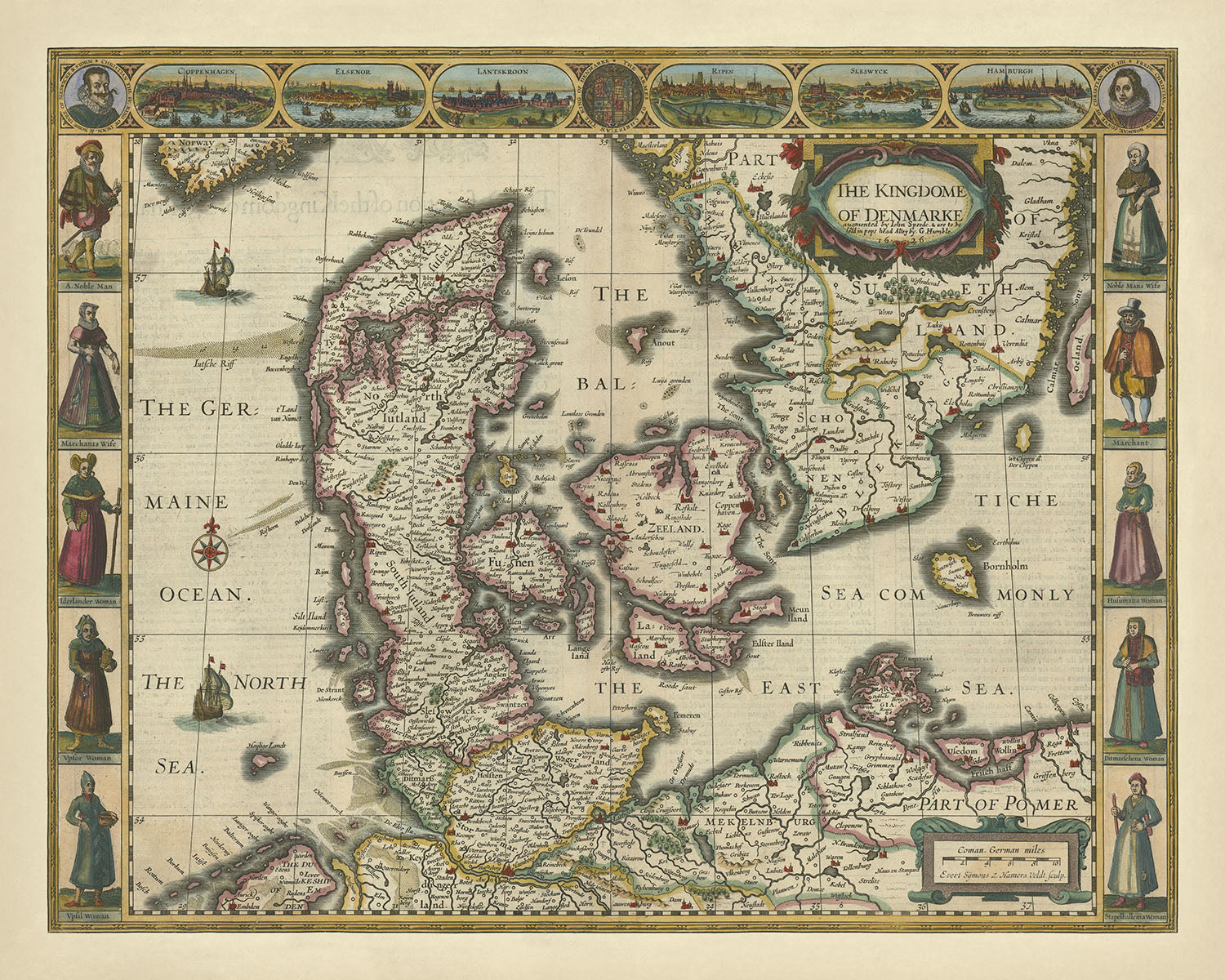
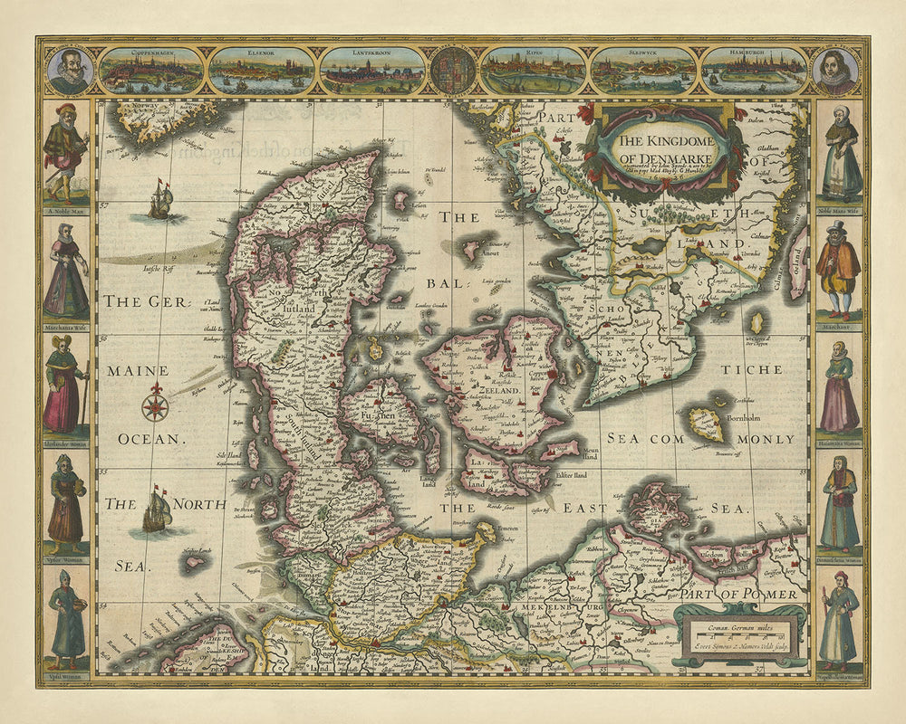


Old Map of the Kingdom of Denmark by Speed, 1626: Copenhagen, Elsinore, Hamburg, Baltic Sea

-
![]() Handmade in the USA
Handmade in the USA
-
FREE worldwide delivery in 2-3 days ⓘ
Free Christmas delivery in 2-3 days
Your map should be delivered in 2-3 working days with free delivery, worldwide.
We make maps by hand locally in 23 countries, including the USA
![]() . If you're buying a gift for someone in another country, we will make the map locally to them.
. If you're buying a gift for someone in another country, we will make the map locally to them.You will never pay import tax or customs duty.
Check the Christmas delivery guide for order deadlines.
Express delivery is available at checkout which can reduce the delivery time to 1-2 days.
Please note that personalised maps, and larger framed maps, can take longer to produce and deliver.
If you need your order to arrive by a certain date, contact me and we can discuss your options.
-
90 day money back guarantee
ⓘ
90 days to return and refund
Products can be returned within 90 days for a full refund, or exchange for another product.
For personalised and custom made items, we may offer you store credit or a non-expiring gift card, as we cannot resell personalised orders.
If you have any questions, get in touch. For more information, see our full returns & exchanges policy.

My maps are rare, museum-grade, restored old maps sourced from libraries, auction houses and private collections across the globe.
Framing & free personalisation available
1. Select your size
2. Frame & personalize your map
Make your map unique with framing, hand-drawn customisation, vintage ageing, pop art text, unique 3D styling and moreGift message & custom finish

If you want to add a gift message, or a finish (jigsaw, aluminium board, etc.) that is not available here, please request it in the "order note" when you check out.
Every order is custom made, so if you need the size adjusted slightly, or printed on an unusual material, just let us know. We've done thousands of custom orders over the years, so there's (almost) nothing we can't manage.
You can also contact us before you order, if you prefer!

- Handmade locally. No import duty or tax
- FREE Delivery. Arrives in 2-3 days
- Love it or your money back
- Questions? WhatsApp me any time
Own a piece of history
5,000+ 5 star reviews


The "Kingdome of Denmarke" map, crafted by the esteemed cartographer John Speed in 1627, is a remarkable historical artifact that offers a glimpse into the political and cultural landscape of early 17th-century Denmark. This map is not merely a geographical representation; it is a work of art that captures the essence of the period through its detailed illustrations and decorative elements. The side panels adorned with costumed figures and the vignettes of notable places such as Copenhagen, Elsinore, Hamburg, and Schleswig add a rich cultural context, making this map a treasure trove of historical information.
John Speed, an illustrious English cartographer and historian, is renowned for his meticulously detailed and aesthetically pleasing maps. His works are celebrated for their artistic quality and historical accuracy, and the "Kingdome of Denmarke" is no exception. Speed's maps were often created to provide a comprehensive view of the regions they depicted, combining geographical detail with cultural and political insights. This map of Denmark is a testament to Speed's skill and dedication to his craft, reflecting the intricate political boundaries and the cultural milieu of the time.
The map vividly portrays the Kingdom of Denmark, along with parts of Germany and Norway, highlighting the political boundaries and geographical features of the region. The German Ocean (North Sea), the Baltic Sea, and the East Sea are prominently depicted, providing a clear understanding of Denmark's maritime borders. The inclusion of sailing ships and a decorative compass rose adds a touch of nautical charm, emphasizing Denmark's historical significance as a seafaring nation. The detailed representation of the coastline and islands further enhances the map's geographical accuracy.
One of the most striking features of this map is the depiction of notable landmarks and cities. Copenhagen, Elsinore, Hamburg, and Schleswig are illustrated with remarkable detail, offering a glimpse into the urban centers of the time. These cities were not only political and economic hubs but also cultural centers that played a significant role in shaping the history of the region. The vignettes above the map provide a visual tour of these important locations, adding depth and context to the geographical information presented.
The design and style of the "Kingdome of Denmarke" map are quintessentially 17th century, characterized by its elaborate decorations and intricate details. The side panels featuring costumed figures provide a fascinating insight into the attire and social customs of the period. This map is more than just a geographical document; it is a cultural artifact that captures the essence of a bygone era. Its historical significance lies not only in its depiction of Denmark's geography but also in its portrayal of the cultural and political landscape of the time, making it a valuable addition to any collection of historical maps.
Cities and towns on this map
- Denmark:
- Copenhagen
- Elsinore
- Germany:
- Hamburg
- Schleswig
Notable Features & Landmarks
- Illustrations:
- Costumed figures in side panels
- Vignettes of notable places above the map
- Landmarks:
- Copenhagen
- Elsinore
- Hamburg
- Schleswig
- Bodies of water:
- The German Ocean (North Sea)
- The Bal (Baltic Sea)
- The East Sea
- Other notable features:
- Decorative compass rose
- Sailing ships
Historical and design context
- Name of the map: The Kingdome of Denmarke
- When the map was made: 1626
- Mapmaker or publisher:
- The map was created by John Speed in 1627.
- John Speed was a notable English cartographer and historian, known for his detailed and decorative maps.
- Topics and themes shown on the map:
- The map is both a political and physical map, showing the geographical features and political boundaries of the Kingdom of Denmark.
- The map also emphasizes cultural aspects by including costumed figures and notable landmarks.
- Countries and regions shown on the map:
- Denmark
- Parts of Germany and Norway
- Design or style of the map:
- The map features detailed illustrations and decorative elements, typical of 17th-century cartography.
- Side panels and top vignettes add cultural and historical context.
- Historical significance or context:
- This map provides a historical snapshot of Denmark in the early 17th century, reflecting the political and cultural landscape of the time.
- John Speed's maps are considered significant for their artistic quality and historical detail.
Please double check the images to make sure that a specific town or place is shown on this map. You can also get in touch and ask us to check the map for you.
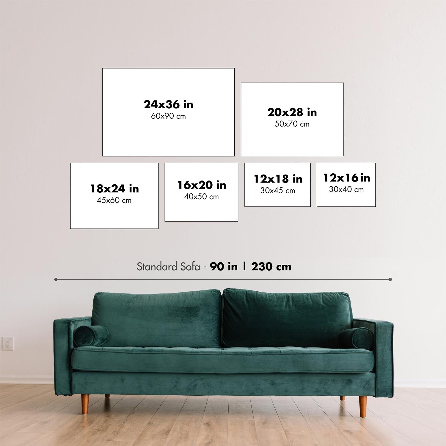
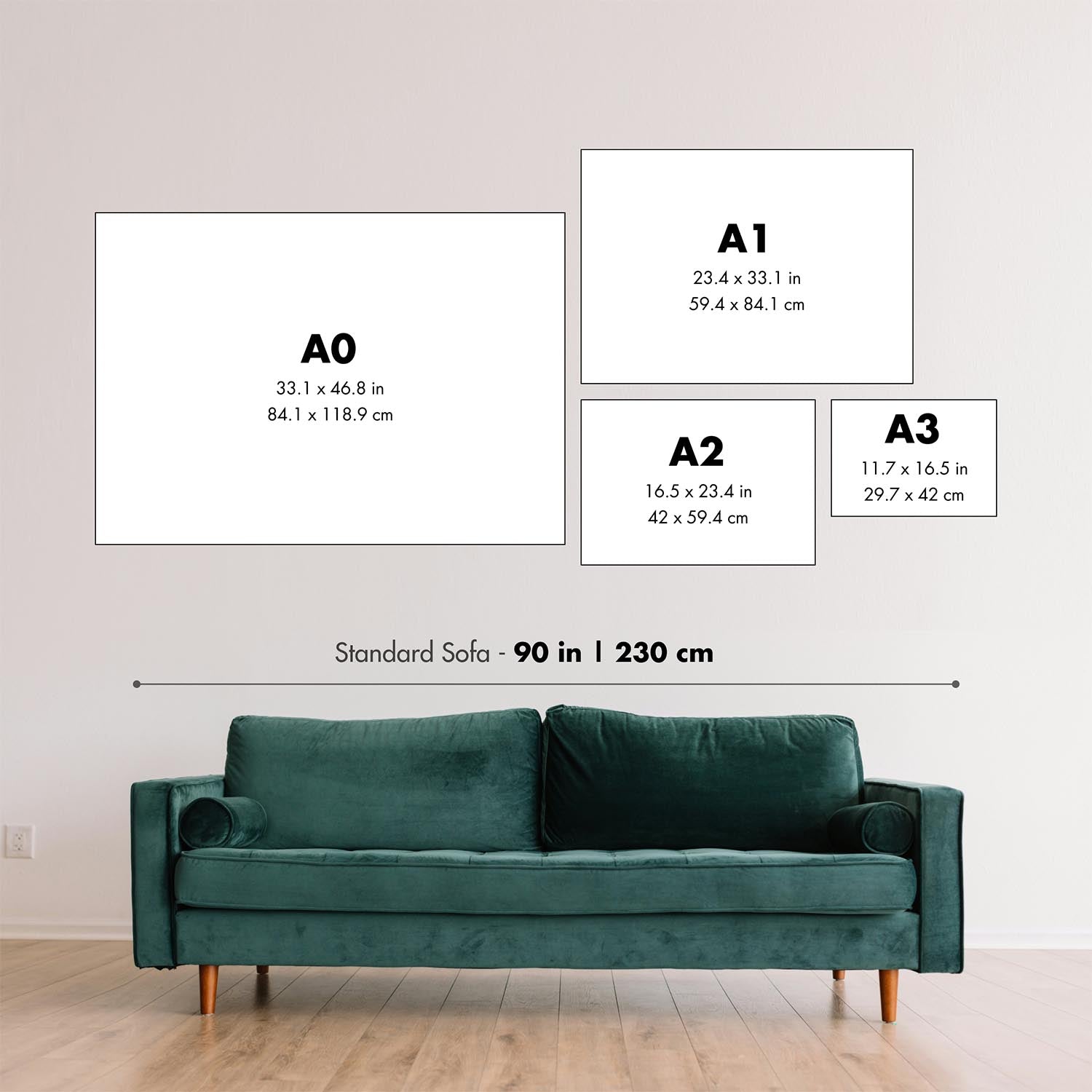
This map looks great at every size, but I always recommend going for a larger size if you have space. That way you can easily make out all of the details.
This map looks amazing at sizes all the way up to 90in (230cm). If you are looking for a larger map, please get in touch.
The model in the listing images is holding the 16x20in (40x50cm) version of this map.
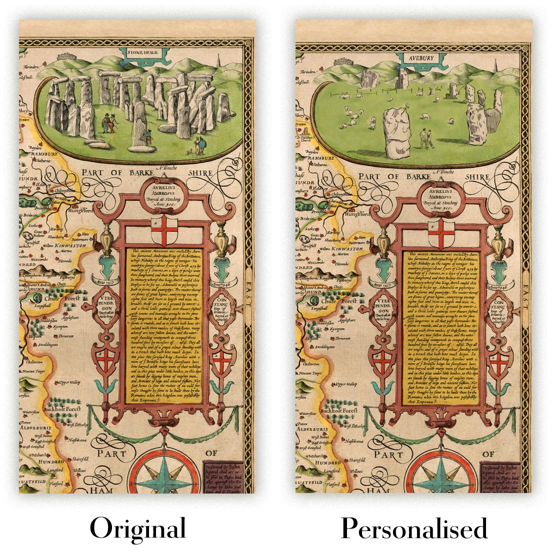
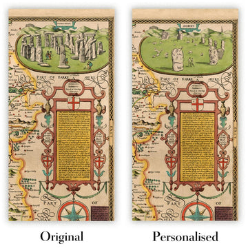
The fifth listing image shows an example of my map personalisation service.
If you’re looking for something slightly different, check out my collection of the best old maps to see if something else catches your eye.
Please contact me to check if a certain location, landmark or feature is shown on this map.
This would make a wonderful birthday, Christmas, Father's Day, work leaving, anniversary or housewarming gift for someone from the areas covered by this map.
This map is available as a giclée print on acid free archival matte paper, or you can buy it framed. The frame is a nice, simple black frame that suits most aesthetics. Please get in touch if you'd like a different frame colour or material. My frames are glazed with super-clear museum-grade acrylic (perspex/acrylite), which is significantly less reflective than glass, safer, and will always arrive in perfect condition.
This map is also available as a float framed canvas, sometimes known as a shadow gap framed canvas or canvas floater. The map is printed on artist's cotton canvas and then stretched over a handmade box frame. We then "float" the canvas inside a wooden frame, which is available in a range of colours (black, dark brown, oak, antique gold and white). This is a wonderful way to present a map without glazing in front. See some examples of float framed canvas maps and explore the differences between my different finishes.
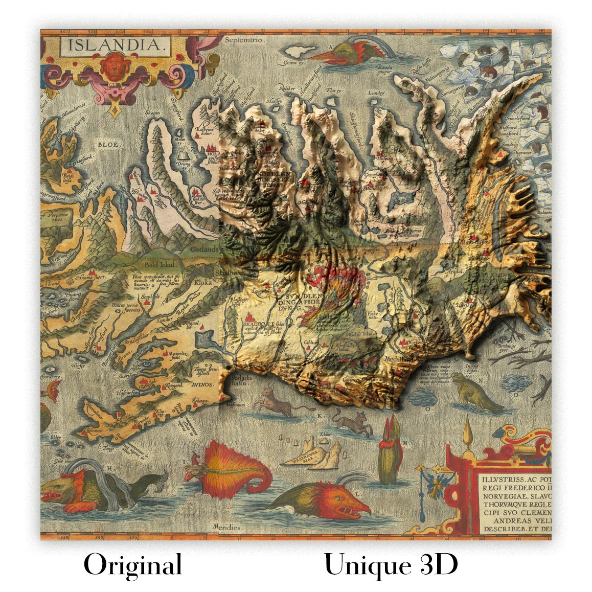
For something truly unique, this map is also available in "Unique 3D", our trademarked process that dramatically transforms the map so that it has a wonderful sense of depth. We combine the original map with detailed topography and elevation data, so that mountains and the terrain really "pop". For more info and examples of 3D maps, check my Unique 3D page.
For most orders, delivery time is about 3 working days. Personalised and customised products take longer, as I have to do the personalisation and send it to you for approval, which usually takes 1 or 2 days.
Please note that very large framed orders usually take longer to make and deliver.
If you need your order to arrive by a certain date, please contact me before you order so that we can find the best way of making sure you get your order in time.
I print and frame maps and artwork in 23 countries around the world. This means your order will be made locally, which cuts down on delivery time and ensures that it won't be damaged during delivery. You'll never pay customs or import duty, and we'll put less CO2 into the air.
All of my maps and art prints are well packaged and sent in a rugged tube if unframed, or surrounded by foam if framed.
I try to send out all orders within 1 or 2 days of receiving your order, though some products (like face masks, mugs and tote bags) can take longer to make.
If you select Express Delivery at checkout your order we will prioritise your order and send it out by 1-day courier (Fedex, DHL, UPS, Parcelforce).
Next Day delivery is also available in some countries (US, UK, Singapore, UAE) but please try to order early in the day so that we can get it sent out on time.
My standard frame is a gallery style black ash hardwood frame. It is simple and quite modern looking. My standard frame is around 20mm (0.8in) wide.
I use super-clear acrylic (perspex/acrylite) for the frame glass. It's lighter and safer than glass - and it looks better, as the reflectivity is lower.
Six standard frame colours are available for free (black, dark brown, dark grey, oak, white and antique gold). Custom framing and mounting/matting is available if you're looking for something else.
Most maps, art and illustrations are also available as a framed canvas. We use matte (not shiny) cotton canvas, stretch it over a sustainably sourced box wood frame, and then 'float' the piece within a wood frame. The end result is quite beautiful, and there's no glazing to get in the way.
All frames are provided "ready to hang", with either a string or brackets on the back. Very large frames will have heavy duty hanging plates and/or a mounting baton. If you have any questions, please get in touch.
See some examples of my framed maps and framed canvas maps.
Alternatively, I can also supply old maps and artwork on canvas, foam board, cotton rag and other materials.
If you want to frame your map or artwork yourself, please read my size guide first.
My maps are extremely high quality reproductions of original maps.
I source original, rare maps from libraries, auction houses and private collections around the world, restore them at my London workshop, and then use specialist giclée inks and printers to create beautiful maps that look even better than the original.
My maps are printed on acid-free archival matte (not glossy) paper that feels very high quality and almost like card. In technical terms the paper weight/thickness is 10mil/200gsm. It's perfect for framing.
I print with Epson ultrachrome giclée UV fade resistant pigment inks - some of the best inks you can find.
I can also make maps on canvas, cotton rag and other exotic materials.
Learn more about The Unique Maps Co.
Map personalisation
If you're looking for the perfect anniversary or housewarming gift, I can personalise your map to make it truly unique. For example, I can add a short message, or highlight an important location, or add your family's coat of arms.
The options are almost infinite. Please see my map personalisation page for some wonderful examples of what's possible.
To order a personalised map, select "personalise your map" before adding it to your basket.
Get in touch if you're looking for more complex customisations and personalisations.
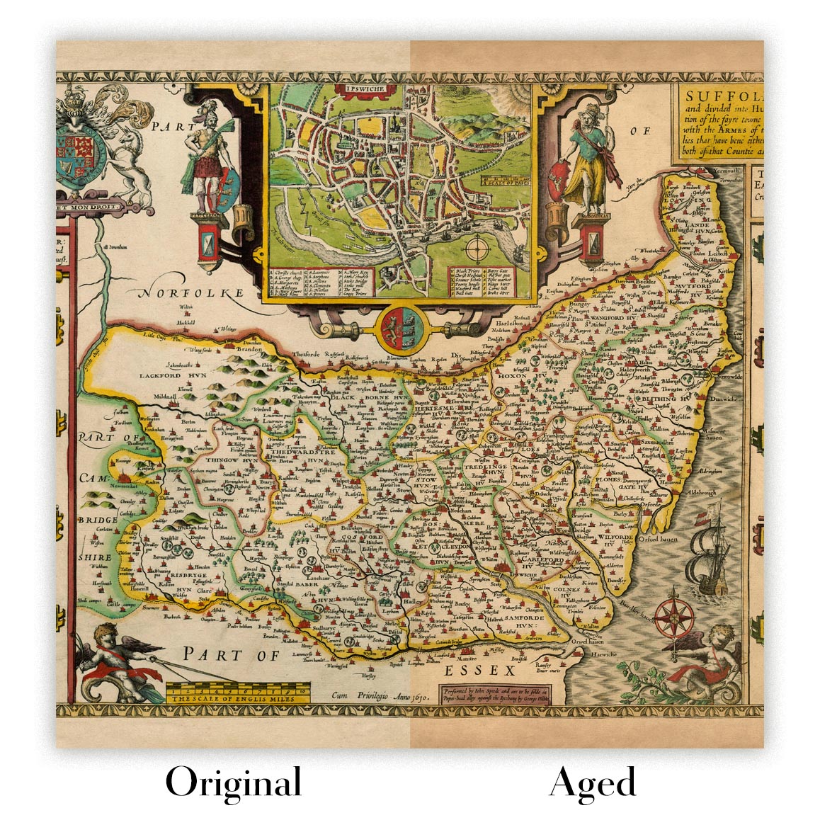
Map ageing
I have been asked hundreds of times over the years by customers if they could buy a map that looks even older.
Well, now you can, by selecting Aged before you add a map to your basket.
All the product photos you see on this page show the map in its Original form. This is what the map looks like today.
If you select Aged, I will age your map by hand, using a special and unique process developed through years of studying old maps, talking to researchers to understand the chemistry of aging paper, and of course... lots of practice!
If you're unsure, stick to the Original colour of the map. If you want something a bit darker and older looking, go for Aged.
If you are not happy with your order for any reason, contact me and I'll get it fixed ASAP, free of charge. Please see my returns and refund policy for more information.
I am very confident you will like your restored map or art print. I have been doing this since 1984. I'm a 5-star Etsy seller. I have sold tens of thousands of maps and art prints and have over 5,000 real 5-star reviews. My work has been featured in interior design magazines, on the BBC, and on the walls of dozens of 5-star hotels.
I use a unique process to restore maps and artwork that is massively time consuming and labour intensive. Hunting down the original maps and illustrations can take months. I use state of the art and eye-wateringly expensive technology to scan and restore them. As a result, I guarantee my maps and art prints are a cut above the rest. I stand by my products and will always make sure you're 100% happy with what you receive.
Almost all of my maps and art prints look amazing at large sizes (200cm, 6.5ft+) and I can frame and deliver them to you as well, via special oversized courier. Contact me to discuss your specific needs.
Or try searching for something!


