


Old Map of Spain & Portugal by Speed, 1626: Madrid, Lisbon, Gibraltar, Biscayen Sea, Cultural Life
Buy 2, Get 1 More Free
If you add 2 items to your bag, you can add a third product for free. The discount is automatic - no code required.
This is equivalent to 33% off, which will be the largest discount available on my shop this year.
This works for all maps and artwork. You can order 3 of the same thing, or 3 different things.
Custom maps are excluded, as they're too time consuming to make and we'd prefer to take our time rather than rush through a lot of orders.
Contact me if you have any questions.
-
![]() Handmade in the USA
Handmade in the USA

-
FREE worldwide delivery in 2-3 days ⓘ
Free delivery in 2-3 days
Your map should be delivered in 2-3 working days with free delivery, worldwide.
We make maps by hand locally in 23 countries, including the USA
![]() . If you're buying a gift for someone in another country, we will make the map locally to them.
. If you're buying a gift for someone in another country, we will make the map locally to them.You will never pay import tax or customs duty.
Express delivery is available at checkout which can reduce the delivery time to 1-2 days.
Please note that personalised maps, and larger framed maps, can take longer to produce and deliver.
If you need your order to arrive by a certain date, contact me and we can discuss your options.
-
Complimentary gifting & design advice
ⓘ
Complimentary gifting & design advice
Available almost 24/7 on WhatsApp and email — we usually reply within minutes. We can help you:
- Choose a perfectly personalised gift
- Send a digital gift preview to the recipient
- Pick the ideal size for your wall
- Select the right finish and frame
Quick, friendly advice so you can order with confidence.
For last minute gifts, consider buying a digital gift card. We have over 5,000 maps and art prints to choose from.
-
90-day returns & 5-year guarantee
ⓘ
90-day returns & 5-year guarantee
Products can be returned within 90 days for a full refund, or exchange for another product.
We are also proud to offer a 5-year quality guarantee on our maps and art, covering defects in materials or workmanship under normal use.
For personalised and custom made items, we may offer you store credit or a non-expiring gift card, as we cannot resell personalised orders.
If you have any questions, get in touch. For more information, see our full returns & exchanges policy.

This is a museum-grade archival print from the original 1626 map — restored in our workshop and made to order on 220gsm archival matte paper or 400gsm artist's cotton canvas with pigment inks.
Professional framing & free personalisation available
1. Choose a size
2. Frame & personalize your map
Make your map unique with framing, hand-drawn customisation, vintage ageing, pop art text, unique 3D styling and more.


Gift message & custom finish

If you want to add a gift message, or a finish (jigsaw, aluminium board, etc.) that is not available here, please request it in the "order note" when you check out.
Every order is custom made, so if you need the size adjusted slightly, or printed on an unusual material, just let us know. We've done thousands of custom orders over the years, so there's (almost) nothing we can't manage.
You can also contact us before you order, if you prefer!

- Handmade locally. No import duty or tax
- FREE worldwide delivery
- 90-day returns & 5-year product guarantee
- Questions? WhatsApp me any time
Own a piece of history
7,000+ 5 star reviews


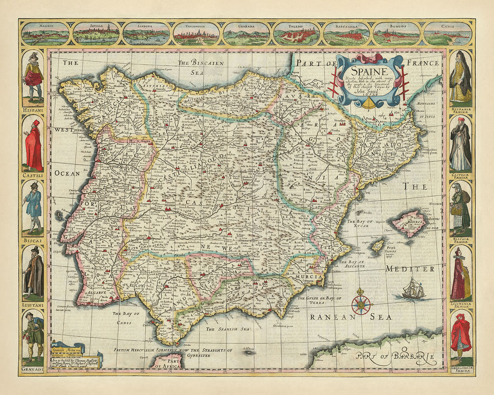
"Spayne Newly described, with many adictions, both in the attires of the people & the Setuations of their cheifest Cityes" is a masterful creation by the renowned English cartographer John Speed, dating back to 1626. This map is not just a geographical representation but a vibrant tapestry that intertwines the cultural and urban elements of the Iberian Peninsula. Published in London by Bassett & Chiswell in 1676, it reflects the meticulous and decorative approach that Speed was celebrated for. The map provides a rich visual narrative of Spain and Portugal, capturing the essence of early modern cartography with its detailed depiction of the region's geography and the colorful attire of its people.
John Speed's map is a window into the 17th century, showcasing the geographical features of Spain and Portugal with an unparalleled level of detail. The map highlights the prominent bodies of water such as the Biscayen Sea, the Mediterranean Sea, and the Bay of Biscay, which were crucial for trade and exploration during that era. It also meticulously outlines the borders between Spain and Portugal and the various regions within Spain, providing a clear understanding of the political landscape of the time. The inclusion of mountain ranges and other natural features adds depth and realism to the map, making it a valuable resource for historians and enthusiasts alike.
One of the most captivating aspects of this map is its portrayal of cultural life through the decorative costumes of the Spanish and Portuguese populations. The borders of the map are adorned with illustrations of traditional attire, offering a visual catalogue of the diverse clothing styles that were prevalent in the 17th century. This artistic choice not only enhances the aesthetic appeal of the map but also serves as a historical record of the cultural variety within the Iberian Peninsula. The inclusion of these costumes reflects the broader trend in 17th-century cartography to capture and celebrate the cultural richness of the regions depicted.
The top border of the map features views of nine prominent Iberian cities, including Madrid, Sevilla, Lisbona, Valladolid, Granada, Toledo, Barcelona, Burgos, and Cadiz. These cityscapes provide a snapshot of the urban vitality and architectural styles of the time, offering a glimpse into the bustling life of these important centers. Each city is meticulously illustrated, showcasing its unique characteristics and significance. This artistic inclusion underscores the importance of urban development in the early modern period and highlights the role these cities played in the cultural and economic life of the Iberian Peninsula.
John Speed's map is more than just a geographical document; it is a testament to the complexities and achievements of early modern mapmaking. It embodies a comprehensive understanding of the Iberian Peninsula, blending geography, culture, and urbanism into a single, cohesive work. The map's detailed depiction of cities, towns, landmarks, and natural features provides valuable insights into the historical context of the region. As a piece of cartographic history, it stands as a remarkable example of the skill and artistry that defined John Speed's work, offering a fascinating glimpse into the world of 17th-century Europe.
Cities and towns on this map
- Spain:
- Madrid
- Barcelona
- Valencia
- Sevilla
- Zaragoza
- Málaga
- Murcia
- Palma
- Las Palmas
- Bilbao
- Alicante
- Córdoba
- Valladolid
- Vigo
- Gijón
- Granada
- A Coruña
- Vitoria-Gasteiz
- Burgos
- Santander
- Toledo
- Cadiz
- Salamanca
- Logroño
- Albacete
- Huelva
- Badajoz
- Tarragona
- Lleida
- Jaen
- Lugo
- Pontevedra
- Palencia
- Guadalajara
- Segovia
- Avila
- Cuenca
- Soria
- Teruel
- Huesca
- Zamora
- Cáceres
- Ciudad Real
- Almería
- Gerona
- Orense
- Melilla
- Ceuta
- Portugal:
- Lisbon (Lisbona)
- Porto
- Braga
- Coimbra
- Aveiro
- Faro
- Évora
- Leiria
- Viseu
- Setúbal
- Viana do Castelo
- Funchal
- Ponta Delgada
Notable Features & Landmarks
- Illustrations:
- Decorative costumes along the left and right borders.
- Cityscapes of nine Iberian cities along the top border.
- Landmarks:
- The Straits of Gibraltar
- Bodies of water:
- The Biscayen Sea
- The Mediterranean Sea
- The Bay of Biscay
- The Bay of Cadiz
- The Bay of Algar
- The Bay of Veara
- The Bay of Xucar
- Borders:
- Borders between Spain and Portugal
- Borders between different regions within Spain
- Mountains:
- Various mountain ranges illustrated within Spain and Portugal (not individually labeled)
Historical and design context
- Rendered in meticulous detail and vibrant hand color.
- Exemplary work of famed cartographer John Speed.
- Published in London by Bassett & Chiswell in 1676, though dating from Speed's 1626 cartographic output.
- Underscores the confluence of geography, culture, and urban development during the early modern period.
- John Speed was a renowned English cartographer known for his meticulous and decorative approach to mapmaking.
- His work provides valuable insight into the geographic knowledge and aesthetic values of the 17th century.
- Geographical features of Spain and Portugal.
- Attires of the people, showcasing the cultural life in the Iberian Peninsula.
- Urban development with cityscapes of prominent Iberian cities.
- Cultural variety through decorative costumes.
- "Carte-a-figure" map style with decorative costumes along the borders.
- Views of nine prominent Iberian cities in the top border.
- Richly colored and detailed.
- Offers an intriguing blend of geography, culture, and urbanism.
- Stands as a testament to the complexities of early modern mapmaking.
- Embodies a comprehensive understanding of the Iberian Peninsula during the era.
Please double check the images to make sure that a specific town or place is shown on this map. You can also get in touch and ask us to check the map for you.
This map looks great at every size, but I always recommend going for a larger size if you have space. That way you can easily make out all of the details.
This map looks amazing at sizes all the way up to 90in (230cm). If you are looking for a larger map, please get in touch.
The model in the listing images is holding the 16x20in (40x50cm) version of this map.
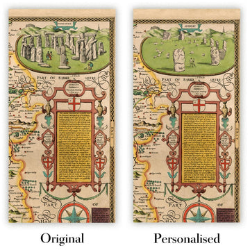
The fifth listing image shows an example of my map personalisation service.
If you’re looking for something slightly different, check out my collection of the best old maps to see if something else catches your eye.
Please contact me to check if a certain location, landmark or feature is shown on this map.
This would make a wonderful birthday, Christmas, Father's Day, work leaving, anniversary or housewarming gift for someone from the areas covered by this map.
This map is available as a giclée print on acid free archival matte paper, or you can buy it framed. The frame is a nice, simple black frame that suits most aesthetics. Please get in touch if you'd like a different frame colour or material. My frames are glazed with super-clear museum-grade acrylic (perspex/acrylite), which is significantly less reflective than glass, safer, and will always arrive in perfect condition.
This map is also available as a float framed canvas, sometimes known as a shadow gap framed canvas or canvas floater. The map is printed on artist's cotton canvas and then stretched over a handmade box frame. We then "float" the canvas inside a wooden frame, which is available in a range of colours (black, dark brown, oak, antique gold and white). This is a wonderful way to present a map without glazing in front. See some examples of float framed canvas maps and explore the differences between my different finishes.
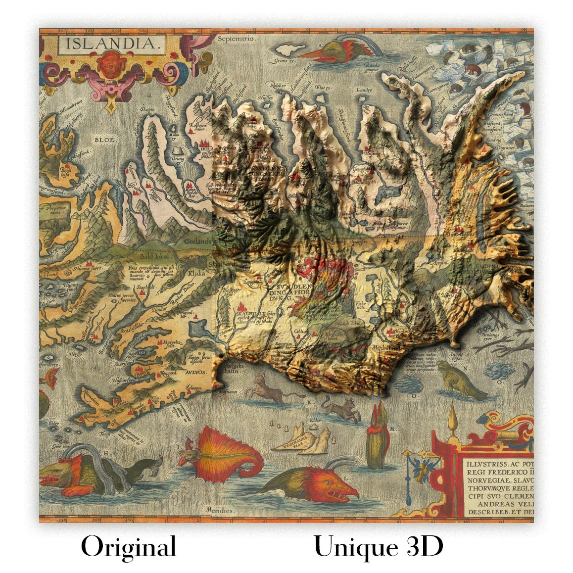
For something truly unique, this map is also available in "Unique 3D", our trademarked process that dramatically transforms the map so that it has a wonderful sense of depth. We combine the original map with detailed topography and elevation data, so that mountains and the terrain really "pop". For more info and examples of 3D maps, check my Unique 3D page.
For most orders, delivery time is about 3 working days. Personalised and customised products take longer, as I have to do the personalisation and send it to you for approval, which usually takes 1 or 2 days.
Please note that very large framed orders usually take longer to make and deliver.
If you need your order to arrive by a certain date, please contact me before you order so that we can find the best way of making sure you get your order in time.
I print and frame maps and artwork in 23 countries around the world. This means your order will be made locally, which cuts down on delivery time and ensures that it won't be damaged during delivery. You'll never pay customs or import duty, and we'll put less CO2 into the air.
All of my maps and art prints are well packaged and sent in a rugged tube if unframed, or surrounded by foam if framed.
I try to send out all orders within 1 or 2 days of receiving your order, though some products (like face masks, mugs and tote bags) can take longer to make.
If you select Express Delivery at checkout your order we will prioritise your order and send it out by 1-day courier (Fedex, DHL, UPS, Parcelforce).
Next Day delivery is also available in some countries (US, UK, Singapore, UAE) but please try to order early in the day so that we can get it sent out on time.
My standard frame is a gallery style black ash hardwood frame. It is simple and quite modern looking. My standard frame is around 20mm (0.8in) wide.
I use super-clear acrylic (perspex/acrylite) for the frame glass. It's lighter and safer than glass - and it looks better, as the reflectivity is lower.
Six standard frame colours are available for free (black, dark brown, dark grey, oak, white and antique gold). Custom framing and mounting/matting is available if you're looking for something else.
Most maps, art and illustrations are also available as a framed canvas. We use matte (not shiny) cotton canvas, stretch it over a sustainably sourced box wood frame, and then 'float' the piece within a wood frame. The end result is quite beautiful, and there's no glazing to get in the way.
All frames are provided "ready to hang", with either a string or brackets on the back. Very large frames will have heavy duty hanging plates and/or a mounting baton. If you have any questions, please get in touch.
See some examples of my framed maps and framed canvas maps.
Alternatively, I can also supply old maps and artwork on canvas, foam board, cotton rag and other materials.
If you want to frame your map or artwork yourself, please read my size guide first.
My maps are extremely high quality reproductions of original maps.
I source original, rare maps from libraries, auction houses and private collections around the world, restore them at my London workshop, and then use specialist giclée inks and printers to create beautiful maps that look even better than the original.
My maps are printed on acid-free archival matte (not glossy) paper that feels very high quality and almost like card. In technical terms the paper weight/thickness is 10mil/200gsm. It's perfect for framing.
I print with Epson ultrachrome giclée UV fade resistant pigment inks - some of the best inks you can find.
I can also make maps on canvas, cotton rag and other exotic materials.
Learn more about The Unique Maps Co.
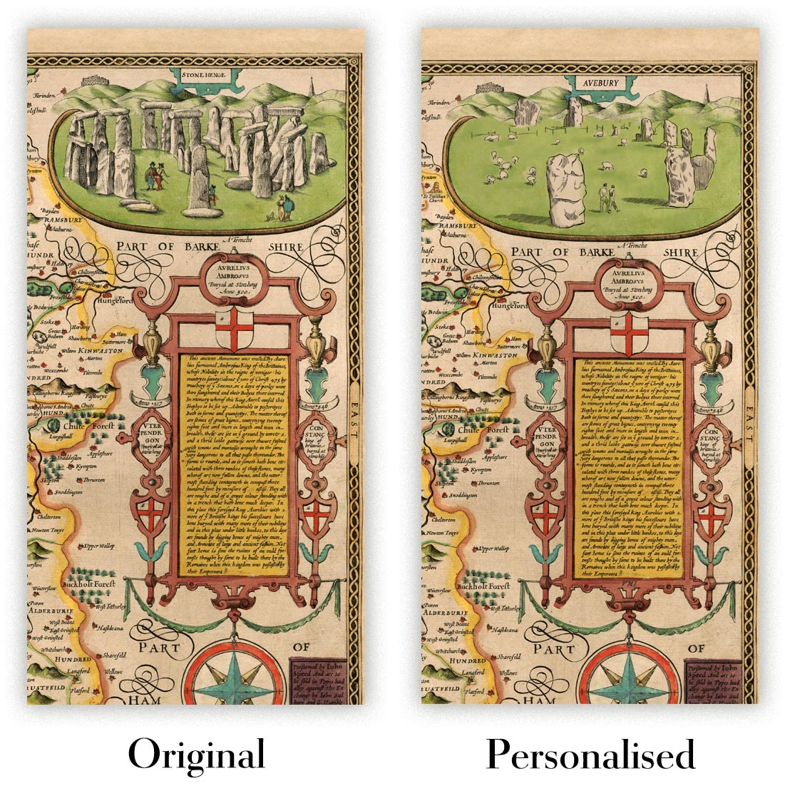
Map personalisation
If you're looking for the perfect anniversary or housewarming gift, I can personalise your map to make it truly unique. For example, I can add a short message, or highlight an important location, or add your family's coat of arms.
The options are almost infinite. Please see my map personalisation page for some wonderful examples of what's possible.
To order a personalised map, select "personalise your map" before adding it to your basket.
Get in touch if you're looking for more complex customisations and personalisations.
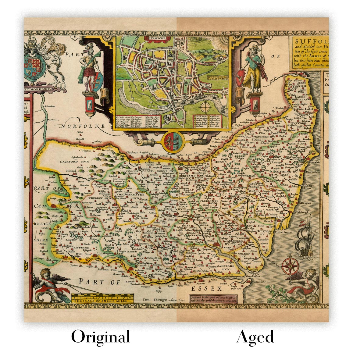
Map ageing
I have been asked hundreds of times over the years by customers if they could buy a map that looks even older.
Well, now you can, by selecting Aged before you add a map to your basket.
All the product photos you see on this page show the map in its Original form. This is what the map looks like today.
If you select Aged, I will age your map by hand, using a special and unique process developed through years of studying old maps, talking to researchers to understand the chemistry of aging paper, and of course... lots of practice!
If you're unsure, stick to the Original colour of the map. If you want something a bit darker and older looking, go for Aged.
If you are not happy with your order for any reason, contact me and I'll get it fixed ASAP, free of charge. Please see my returns and refund policy for more information.
I am very confident you will like your restored map or art print. I have been doing this since 1984. I'm a 5-star Etsy seller. I have sold tens of thousands of maps and art prints and have over 5,000 real 5-star reviews. My work has been featured in interior design magazines, on the BBC, and on the walls of dozens of 5-star hotels.
I use a unique process to restore maps and artwork that is massively time consuming and labour intensive. Hunting down the original maps and illustrations can take months. I use state of the art and eye-wateringly expensive technology to scan and restore them. As a result, I guarantee my maps and art prints are a cut above the rest. I stand by my products and will always make sure you're 100% happy with what you receive.
Almost all of my maps and art prints look amazing at large sizes (200cm, 6.5ft+) and I can frame and deliver them to you as well, via special oversized courier. Contact me to discuss your specific needs.
Or try searching for something!


