

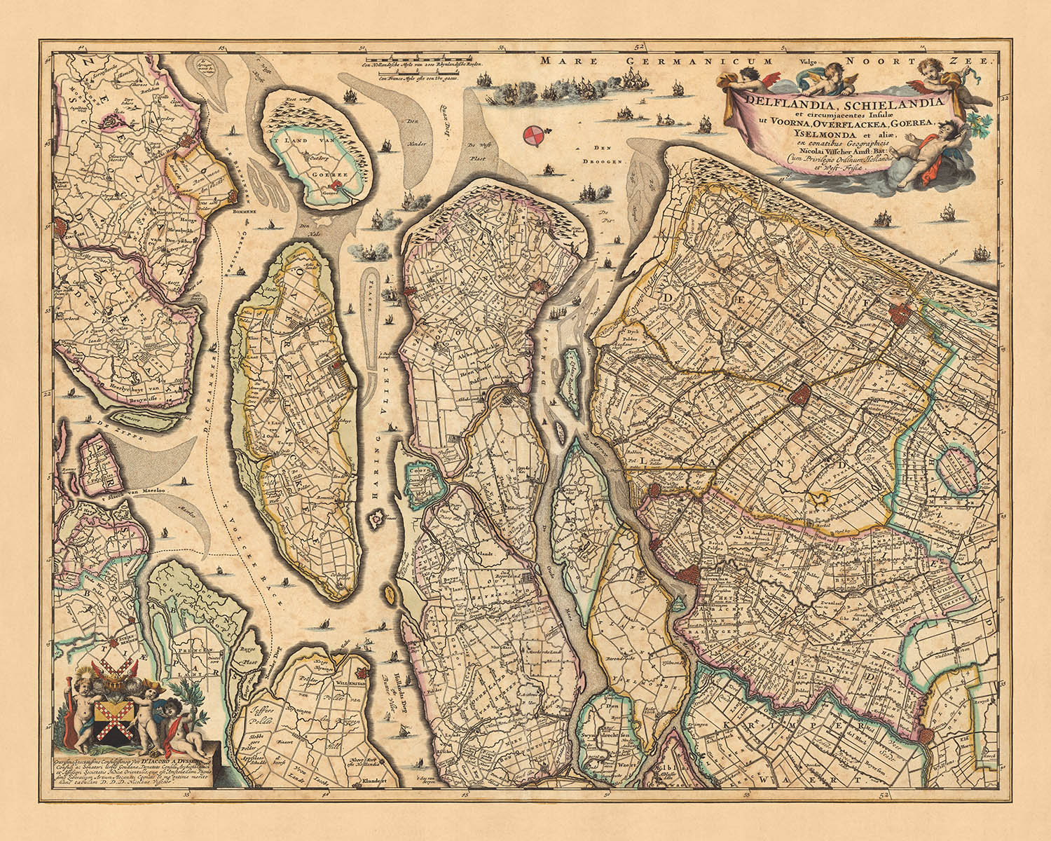


Old Map of Delfland and Schieland by Visscher, 1690: The Hague, Rotterdam, Delft, Hellevoetsluis, Ridderkerk
20% off 2 — 33% off 3
Add any two eligible items to your bag to receive 20% off. Add a third and it will be complimentary (equivalent to 33% off when purchasing three).
No code needed — the offer applies automatically at checkout.
Valid on all standard maps and fine art prints. You can mix and match any designs.
If you’d like to ship items to multiple addresses, please contact us before placing your order.
Custom and bespoke commissions are excluded.
Contact us if you have any questions
-
![]() Made to order locally in the USA
Made to order locally in the USA

-
Free delivery 2-3 days ⓘ
Free delivery in 2-3 days
Your map should be delivered in 2-3 working days with free delivery, worldwide.
We make maps by hand locally in 23 countries, including the USA
![]() . If you're buying a gift for someone in another country, we will make the map locally to them.
. If you're buying a gift for someone in another country, we will make the map locally to them.You will never pay import tax or customs duty.
Express delivery is available at checkout which can reduce the delivery time to 1-2 days.
Please note that personalised maps, and larger framed maps, can take longer to produce and deliver.
If you need your order to arrive by a certain date, contact me and we can discuss your options.
-
Complimentary gifting & design advice
ⓘ
Complimentary gifting & design advice
Available almost 24/7 on WhatsApp and email — we usually reply within minutes. We can help you:
- Choose a perfectly personalised gift
- Send a digital gift preview to the recipient
- Pick the ideal size for your wall
- Select the right finish and frame
Quick, friendly advice so you can order with confidence.
For last minute gifts, consider buying a digital gift card. We have over 5,000 maps and art prints to choose from.
-
90-day returns & 5-year guarantee
ⓘ
90-day returns & 5-year guarantee
Products can be returned within 90 days for a full refund, or exchange for another product.
We are also proud to offer a 5-year quality guarantee on our maps and art, covering defects in materials or workmanship under normal use.
For personalised and custom made items, we may offer you store credit or a non-expiring gift card, as we cannot resell personalised orders.
If you have any questions, get in touch. For more information, see our full returns & exchanges policy.

This is a museum-grade archival print from the original 1690 map — restored in our workshop and made to order on 220gsm archival matte paper or 400gsm artist's cotton canvas with pigment inks.
Beautifully framed and ready to hang, with complimentary personalization available.
Choose your size
Choose your frame


Gift message & custom finish

If you want to add a gift message, or a finish (jigsaw, aluminium board, etc.) that is not available here, please request it in the "order note" when you check out.
Every order is custom made, so if you need the size adjusted slightly, or printed on an unusual material, just let us know. We've done thousands of custom orders over the years, so there's (almost) nothing we can't manage.
You can also contact us before you order, if you prefer!

- Handmade locally. No import duty or tax
- FREE worldwide delivery
- 90-day returns & 5-year product guarantee
- Questions? WhatsApp me any time
Own a piece of history
7,000+ 5 star reviews


This remarkable piece of history is an old map of Delfland and Schieland, meticulously crafted by Nicolaes Visscher II in 1690. As part of the Dutch Golden Age, Visscher's maps were renowned for their precision and attention to detail, and this map is no exception. The full name of the map, 'Delflandia, Schielandia et circumjacentes insulae ut Voorna, Overflackae, Goerae, Yselmonda et aliae', translates to 'Delfland, Schieland and the surrounding islands such as Voorne, Overflakkee, Goeree, IJsselmonde and others'. This provides a clear indication of the regions and political divisions that the map covers, which is primarily the modern-day area of the Netherlands.
The map prominently features five notable locations: The Hague, Rotterdam, Delft, Hellevoetsluis, and Ridderkerk. Each of these cities holds a rich history and played significant roles in the development of the Netherlands. The Hague, for instance, is the seat of the Dutch government and the King, while Rotterdam, with its strategic location along the Rhine-Meuse-Scheldt delta, has been a major logistic and economic centre for centuries.
Delft, a city known for its historic town centre with canals, is also highlighted on this map. It is famous for its association with the Dutch royal family, the House of Orange-Nassau. Hellevoetsluis, a small city located on the Haringvliet, was a major base for the Dutch navy during the Dutch Golden Age. Lastly, Ridderkerk, a town located in the western Netherlands, in the province of South Holland, is also depicted on this map.
The Visscher family's legacy in map-making is evident in this work. The detail and precision with which they captured the topography and political boundaries of the time are a testament to their skill and the significant role they played in the cartography of the Dutch Golden Age. This map is not just a piece of art; it is a window into the past, providing insight into the geographical and political landscape of the Netherlands in the late 17th century.
Some of the significant locations shown on this map:
Delfland
- The Hague (Den Haag): Known as 's-Gravenhage in Dutch, it is the seat of the Dutch government and the King. Founded in 1230.
- Delft: Famous for its historic town centre with canals and its association with the Dutch royal family, the House of Orange-Nassau. Founded in 1075.
- Vlaardingen: Known for its herring fishing industry in the Middle Ages. Founded in 700.
- Schiedam: Known for its historic windmills, some of the largest in the world. Founded in 1230.
- Maassluis: A significant seaport during the Dutch Golden Age. Founded in 1340.
- Naaldwijk: The administrative center of the Westland region. Founded in 1230.
- Monster: Known for its long sandy beach along the North Sea. Founded in 1204.
- De Lier: Known for its horticulture and flower industry. Founded in 1282.
- Wateringen: Known for its historic windmill, De Windlust. Founded in 1156.
- Poeldijk: Known for its historic Roman Catholic church, the Bartholomeuskerk. Founded in 1200.
Schieland
- Rotterdam: A major logistic and economic centre, known for its strategic location along the Rhine-Meuse-Scheldt delta. Founded in 1270.
- Gouda: Known for its cheese, smoking pipes, and 15th-century city hall. Founded in 1139.
- Schoonhoven: Known as the Silver City due to its historic silver industry. Founded in 1220.
- Capelle aan den IJssel: Known for its historic windmill, De Windlust. Founded in 1271.
- Nieuwerkerk aan den IJssel: Known for having the lowest point in the Netherlands. Founded in 1250.
- Krimpen aan den IJssel: Known for its historic storm surge barrier, the Hollandsche IJsselkering. Founded in 1274.
- Moordrecht: Known for its historic churches, such as the Hervormde kerk. Founded in 1260.
- Bergambacht: Known for its traditional cheese farm, the Boerderij de Jong. Founded in 1240.
- Lekkerkerk: Known for its location along the Lek River. Founded in 1282.
- Krimpen aan de Lek: Known for its historic shipyard, the Royal IHC. Founded in 1277.
Surrounding Islands
- Hellevoetsluis: A major base for the Dutch navy during the Dutch Golden Age. Founded in 1312.
- Ridderkerk: Known for its historic Reformed church. Founded in 1040.
- Brielle: Known for its well-preserved fortifications. Founded in 1306.
- Spijkenisse: Known for its modern architecture, such as the Boekenberg. Founded in 1231.
- Goedereede: Known for its historic lighthouse. Founded in 1312.
- Middelharnis: Known for its historic harbor. Founded in 1465.
- Dirksland: Known for its historic hospital, the Van Weel-Bethesda Hospital. Founded in 1412.
- Ouddorp: Known for its long sandy beach along the North Sea. Founded in 1305.
- Ooltgensplaat: Known for its historic fortress, Fort Prins Frederik. Founded in 1313.
- Nieuwe-Tonge: Known for its historic windmill, the Battenoord. Founded in 1482.
Notable Boundaries and Natural Phenomena
- Rhine-Meuse-Scheldt delta: A major river delta in the Netherlands formed by the confluence of the Rhine, Meuse, and Scheldt rivers.
- Haringvliet: A large inlet of the North Sea, and a significant body of water in the Netherlands.
- Biesbosch National Park: One of the largest national parks in the Netherlands and one of the last extensive areas of freshwater tidal wetlands in Northwestern Europe.
- The Maeslantkering: A storm surge barrier on the Nieuwe Waterweg, part of the Delta Works.
- Rotterdam's Historic Harbor: Known as the largest port in Europe.
Notable Historical Events (1600-1690)
- The Dutch Golden Age (17th Century): A period in Dutch history, typically associated with commercial and artistic success, during which the Dutch Republic was one of the world's leading powers.
- The Eighty Years' War (1568–1648): A revolt of the Seventeen Provinces against the political and religious hegemony of Philip II of Spain, the sovereign of the Habsburg Netherlands.
- The Disaster Year (1672): Known in Dutch history as the Rampjaar, when the Dutch Republic was simultaneously attacked by England, France, and the Bishoprics of Münster and Cologne.
Please double check the images to make sure that a specific town or place is shown on this map. You can also get in touch and ask us to check the map for you.
This map looks great at all sizes: 12x16in (30.5x41cm), 16x20in (40.5x51cm), 18x24in (45.5x61cm), 24x30in (61x76cm), 32x40in (81.5x102cm), 40x50in (102x127cm), 48x60in (122x153cm) and 56x70in (142x178cm), but it looks even better when printed large.
I can create beautiful, large prints of this map up to 90in (229cm). Please get in touch if you're looking for larger, customised or different framing options.
The model in the listing images is holding the 16x20in (40.5x51cm) version of this map.
The fifth listing image shows an example of my map personalisation service.
If you’re looking for something slightly different, check out my collection of the best old maps of Europe and European cities to see if something else catches your eye.
Please contact me to check if a certain location, landmark or feature is shown on this map.
This would make a wonderful birthday, Christmas, Father's Day, work leaving, anniversary or housewarming gift for someone from the areas covered by this map.
This map is available as a giclée print on acid free archival matte paper, or you can buy it framed. The frame is a nice, simple black frame that suits most aesthetics. Please get in touch if you'd like a different frame colour or material. My frames are glazed with super-clear museum-grade acrylic (perspex/acrylite), which is significantly less reflective than glass, safer, and will always arrive in perfect condition.
This map is also available as a float framed canvas, sometimes known as a shadow gap framed canvas or canvas floater. The map is printed on artist's cotton canvas and then stretched over a handmade box frame. We then "float" the canvas inside a wooden frame, which is available in a range of colours (black, dark brown, oak, antique gold and white). This is a wonderful way to present a map without glazing in front. See some examples of float framed canvas maps and explore the differences between my different finishes.
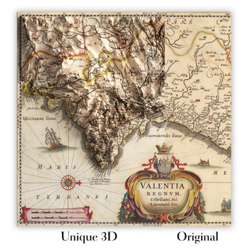
For something truly unique, this map is also available in "Unique 3D", our trademarked process that dramatically transforms the map so that it has a wonderful sense of depth. We combine the original map with detailed topography and elevation data, so that mountains and the terrain really "pop". For more info and examples of 3D maps, check my Unique 3D page.
For most orders, delivery time is about 3 working days. Personalised and customised products take longer, as I have to do the personalisation and send it to you for approval, which usually takes 1 or 2 days.
Please note that very large framed orders usually take longer to make and deliver.
If you need your order to arrive by a certain date, please contact me before you order so that we can find the best way of making sure you get your order in time.
I print and frame maps and artwork in 23 countries around the world. This means your order will be made locally, which cuts down on delivery time and ensures that it won't be damaged during delivery. You'll never pay customs or import duty, and we'll put less CO2 into the air.
All of my maps and art prints are well packaged and sent in a rugged tube if unframed, or surrounded by foam if framed.
I try to send out all orders within 1 or 2 days of receiving your order, though some products (like face masks, mugs and tote bags) can take longer to make.
If you select Express Delivery at checkout your order we will prioritise your order and send it out by 1-day courier (Fedex, DHL, UPS, Parcelforce).
Next Day delivery is also available in some countries (US, UK, Singapore, UAE) but please try to order early in the day so that we can get it sent out on time.
My standard frame is a gallery style black ash hardwood frame. It is simple and quite modern looking. My standard frame is around 20mm (0.8in) wide.
I use super-clear acrylic (perspex/acrylite) for the frame glass. It's lighter and safer than glass - and it looks better, as the reflectivity is lower.
Six standard frame colours are available for free (black, dark brown, dark grey, oak, white and antique gold). Custom framing and mounting/matting is available if you're looking for something else.
Most maps, art and illustrations are also available as a framed canvas. We use matte (not shiny) cotton canvas, stretch it over a sustainably sourced box wood frame, and then 'float' the piece within a wood frame. The end result is quite beautiful, and there's no glazing to get in the way.
All frames are provided "ready to hang", with either a string or brackets on the back. Very large frames will have heavy duty hanging plates and/or a mounting baton. If you have any questions, please get in touch.
See some examples of my framed maps and framed canvas maps.
Alternatively, I can also supply old maps and artwork on canvas, foam board, cotton rag and other materials.
If you want to frame your map or artwork yourself, please read my size guide first.
My maps are extremely high quality reproductions of original maps.
I source original, rare maps from libraries, auction houses and private collections around the world, restore them at my London workshop, and then use specialist giclée inks and printers to create beautiful maps that look even better than the original.
My maps are printed on acid-free archival matte (not glossy) paper that feels very high quality and almost like card. In technical terms the paper weight/thickness is 10mil/200gsm. It's perfect for framing.
I print with Epson ultrachrome giclée UV fade resistant pigment inks - some of the best inks you can find.
I can also make maps on canvas, cotton rag and other exotic materials.
Learn more about The Unique Maps Co.
Map personalisation
If you're looking for the perfect anniversary or housewarming gift, I can personalise your map to make it truly unique. For example, I can add a short message, or highlight an important location, or add your family's coat of arms.
The options are almost infinite. Please see my map personalisation page for some wonderful examples of what's possible.
To order a personalised map, select "personalise your map" before adding it to your basket.
Get in touch if you're looking for more complex customisations and personalisations.
Map ageing
I have been asked hundreds of times over the years by customers if they could buy a map that looks even older.
Well, now you can, by selecting Aged before you add a map to your basket.
All the product photos you see on this page show the map in its Original form. This is what the map looks like today.
If you select Aged, I will age your map by hand, using a special and unique process developed through years of studying old maps, talking to researchers to understand the chemistry of aging paper, and of course... lots of practice!
If you're unsure, stick to the Original colour of the map. If you want something a bit darker and older looking, go for Aged.
If you are not happy with your order for any reason, contact me and I'll get it fixed ASAP, free of charge. Please see my returns and refund policy for more information.
I am very confident you will like your restored map or art print. I have been doing this since 1984. I'm a 5-star Etsy seller. I have sold tens of thousands of maps and art prints and have over 5,000 real 5-star reviews. My work has been featured in interior design magazines, on the BBC, and on the walls of dozens of 5-star hotels.
I use a unique process to restore maps and artwork that is massively time consuming and labour intensive. Hunting down the original maps and illustrations can take months. I use state of the art and eye-wateringly expensive technology to scan and restore them. As a result, I guarantee my maps and art prints are a cut above the rest. I stand by my products and will always make sure you're 100% happy with what you receive.
Almost all of my maps and art prints look amazing at large sizes (200cm, 6.5ft+) and I can frame and deliver them to you as well, via special oversized courier. Contact me to discuss your specific needs.
Or try searching for something!


