


Ancienne carte du Dominion du Canada, 1922: Grands Lacs, Montagnes Rocheuses, Routes Maritimes, Archipel Arctique
20% de réduction sur 2 — 33% de réduction sur 3
Ajoutez n'importe quel deux articles éligibles à votre panier pour recevoir 20% de réduction. Ajoutez un troisième et il sera offert (équivalent à 33% de réduction lors de l'achat de trois).
Aucun code nécessaire — l'offre s'applique automatiquement au moment du paiement.
Valide sur toutes les cartes standard et les impressions d'art. Vous pouvez mélanger et assortir n'importe quel design.
Si vous souhaitez expédier des articles à plusieurs adresses, veuillez nous contacter avant de passer votre commande.
Les commandes personnalisées et sur mesure sont exclues.
Contactez-nous si vous avez des questions
 Conçu à Londres Fabriqué en the USA
Conçu à Londres • Fabriqué en the USA
Conçu à Londres Fabriqué en the USA
Conçu à Londres • Fabriqué en the USA

Choose your size
Choose your finish


(Plus d’infos)
Message cadeau & finition personnalisée

Si vous souhaitez ajouter un message cadeau, ou une finition (puzzle, panneau en aluminium, etc.) qui n'est pas disponible ici, veuillez le demander dans la "note de commande" lors de votre passage à la caisse.
Chaque commande est fabriquée sur mesure, donc si vous avez besoin d'ajuster légèrement la taille, ou d'imprimer sur un matériau inhabituel, faites-le nous savoir. Nous avons réalisé des milliers de commandes personnalisées au fil des ans, donc il n'y a (presque) rien que nous ne puissions gérer.
Vous pouvez également nous contacter avant de passer votre commande, si vous le souhaitez !

- Made locally for fast, safe delivery
- No import duty or hidden fees
- Need advice? Message us on WhatsApp
Own a piece of history
7,000+ 5 star reviews


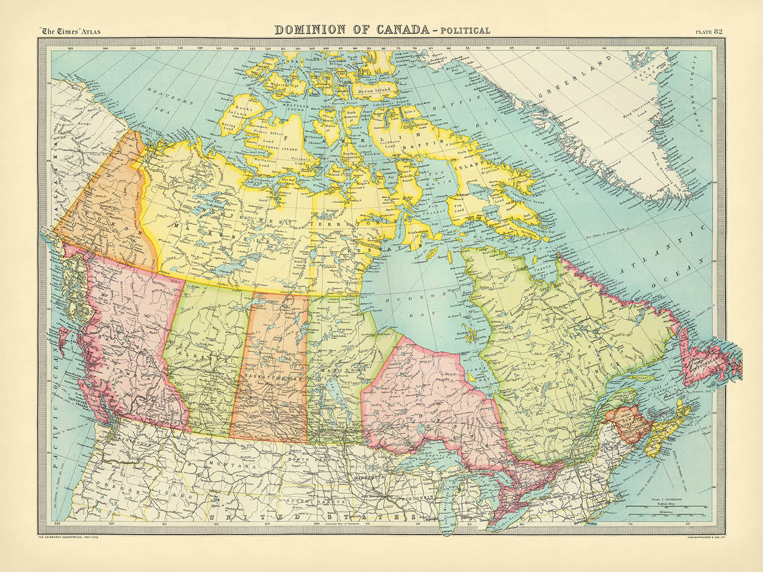
Entrez dans le début du vingtième siècle avec la carte « Dominion du Canada – politique », une œuvre maîtresse du célèbre cartographe britannique J. G. Bartholomew, publiée en 1922. Cette carte, produite pour le prestigieux Times Atlas & Gazetteer of the World, a marqué un moment crucial dans l'histoire cartographique, inaugurant une nouvelle ère de clarté et de précision dans la représentation géographique. L'approche méticuleuse de Bartholomew est évidente dans chaque détail, de la délimitation soignée des frontières provinciales à la représentation nuancée du vaste et varié terrain du Canada. Cette carte n'est pas simplement un enregistrement des frontières politiques ; c'est une fenêtre sur les aspirations et les réalités d'une jeune nation encore en train de définir sa place sur la scène mondiale.
L'art de Bartholomew brille à travers sa représentation des caractéristiques naturelles monumentales du Canada. L'immense étendue des montagnes Rocheuses s'élève à l'ouest, leur présence rendue avec un subtil relief et des altitudes ponctuelles, tandis que les montagnes laurentiennes ancrent le paysage du Québec. Les grandes rivières telles que le Saint-Laurent, le Mackenzie et le Fraser serpentent à travers la carte, traçant les artères du commerce et de l'exploration qui ont façonné l'histoire du pays. D'immenses étendues d'eau—y compris la baie d'Hudson, les Grands Lacs et le golfe du Saint-Laurent—sont représentées avec une clarté qui invite le spectateur à imaginer les voyages des navires et des colons à travers ces frontières redoutables.
La précision politique de la carte est égalée par son attention aux complexités des divisions administratives du Canada telles qu'elles se présentaient dans les années 1920. Chaque province et territoire est rendu dans une couleur distincte, leurs frontières clairement définies contre l'immense étendue du bouclier canadien et la toundra arctique. La frontière internationale avec les États-Unis, y compris le poste avancé de l'Alaska, est clairement marquée, soulignant la position du Canada en tant qu'entité à la fois nord-américaine et mondiale. Des cartes en surimpression fournissent des détails supplémentaires, tandis qu'une page dédiée aux corrections témoigne de l'engagement du cartographe envers l'exactitude dans un monde en rapide évolution.
Une caractéristique notable de cette carte est sa représentation complète des routes maritimes, accompagnée de distances précises entre les ports clés. Ces routes, s'étendant à travers l'Atlantique et le long des côtes tentaculaires du Canada, reflètent le rôle vital de la navigation maritime dans le développement économique et social du pays. L'inclusion des grandes îles—Terre-Neuve, l'Île-du-Prince-Édouard, l'Île de Vancouver et l'archipel arctique éloigné—met en évidence les défis et les opportunités présentés par la géographie maritime du Canada. L'annotation soignée des rivières, des détroits et des lacs enrichit encore notre compréhension des barrières naturelles et des corridors qui ont façonné l'histoire canadienne.
La présence humaine est mise en avant de manière réfléchie, avec des villes et des villages tels que Toronto, Montréal, Vancouver et Ottawa se démarquant comme des phares de croissance et de modernité. Des communautés plus petites, du port animé de Halifax aux avant-postes nordiques de Whitehorse et Yellowknife, témoignent de la diversité et de la résilience de la population canadienne. Cette carte, dans sa synthèse élégante de la géographie physique et politique, offre non seulement un instantané d'une nation en évolution mais aussi un témoignage de l'héritage durable de Bartholomew en tant que l'un des grands cartographes de son époque.
Villes et villages sur cette carte
- Toronto (Ontario) – plus grande population moderne
- Montréal (Québec)
- Calgary (Alberta)
- Ottawa (Ontario)
- Edmonton (Alberta)
- Winnipeg (Manitoba)
- Vancouver (Colombie-Britannique)
- Ville de Québec (Québec)
- Hamilton (Ontario)
- Halifax (Nouvelle-Écosse)
- Victoria (Colombie-Britannique)
- Saskatoon (Saskatchewan)
- Regina (Saskatchewan)
- St. John's (Terre-Neuve)
- St. Catharines (Ontario)
- London (Ontario)
- Windsor (Ontario)
- Charlottetown (Île-du-Prince-Édouard)
- Fredericton (Nouveau-Brunswick)
- Saint John (Nouveau-Brunswick)
- Moncton (Nouveau-Brunswick)
- Thunder Bay (Ontario)
- Sudbury (Ontario)
- Sault Ste. Marie (Ontario)
- Whitehorse (Yukon)
- Yellowknife (Territoires du Nord-Ouest)
- Seattle (Washington, USA)
- Detroit (Michigan, USA)
- Minneapolis (Minnesota, USA)
- Buffalo (New York, USA)
- Duluth (Minnesota, USA)
- Portland (Maine, USA)
Caractéristiques et points d'intérêt notables
- Carte insérée : Une carte détaillée fournissant des informations géographiques supplémentaires
- Routes maritimes : De nombreuses voies de navigation transatlantiques et côtières marquées avec des distances
- Principales étendues d'eau : Baie d'Hudson, Grands Lacs (Supérieur, Michigan, Huron, Érié, Ontario), Golfe du Saint-Laurent, Lac Winnipeg, Lac Athabasca, Lac des Bois, Océans Pacifique et Atlantique
- Frontières : Limites provinciales et territoriales au Canada, frontière internationale avec les États-Unis (y compris l'Alaska)
- Montagnes : Les Montagnes Rocheuses, les Montagnes laurentiennes et les chaînes côtières en Colombie-Britannique
- Îles et archipels : Terre-Neuve, Île-du-Prince-Édouard, Île de Vancouver, Îles de la Reine Charlotte (aujourd'hui Haida Gwaii), Archipel arctique (y compris l'île de Baffin, l'île Victoria, l'île d'Ellesmere)
- Rivières : Principales rivières telles que le Saint-Laurent, le Mackenzie, le Yukon, le Saskatchewan et le Fraser
- Caractéristiques de relief : Hauteurs de points et ombrage pour indiquer l'élévation et le terrain
- Notes de correction : Section notant les corrections de l'édition de 1920, soulignant l'exactitude
- Contexte international : Régions voisines telles que le Groenland, l'Alaska (USA), et les États du nord des USA inclus pour référence
Contexte historique et de conception
- Créé en 1922 par J. G. (John George) Bartholomew, un cartographe britannique renommé connu pour l'avancement des techniques de cartographie moderne
- Produit pour la deuxième édition de l'édition de 1920 de The Times Atlas & Gazetteer of the World, marquant un tournant crucial par rapport aux cartes produites précédemment en Allemagne
- La première édition du Times Atlas à présenter les cartes de Bartholomew, établissant une nouvelle norme pour la clarté, l'exactitude et le design visuel
- Capture la compréhension politique et géographique du Canada peu après la Première Guerre mondiale et avant que Terre-Neuve ne rejoigne la Confédération (1949)
- Représente une période de construction et d'expansion de la nation canadienne, avec un accent sur les routes de transport et de communication
- Caractéristique de la cartographie britannique du début du 20e siècle, avec une différenciation claire des couleurs pour les provinces, un étiquetage détaillé et un accent sur la géographie politique et physique
- Comprend une page dédiée aux corrections, reflétant la nature évolutive de la cartographie et l'engagement à fournir des informations à jour
Veuillez vérifier les images pour vous assurer qu'une ville ou un lieu spécifique est montré sur cette carte. Vous pouvez également nous contacter et nous demander de vérifier la carte pour vous.
Cette carte est superbe à toutes les tailles, mais je recommande toujours d'opter pour une taille plus grande si vous avez de l'espace. De cette façon, vous pouvez facilement distinguer tous les détails.
Cette carte a l'air incroyable dans des tailles allant jusqu'à 70in (180cm). Si vous recherchez une carte plus grande, veuillez nous contacter.
Veuillez noter : les étiquettes sur cette carte sont difficiles à lire si vous commandez une carte de 16in (40cm) ou moins. La carte est toujours très attrayante, mais si vous souhaitez lire la carte facilement, veuillez acheter une taille plus grande.
Le modèle sur les images de la liste tient la version 18x24in (45x60cm) de cette carte.
La cinquième image de la liste montre un exemple de mon service de personnalisation de carte.
Si vous recherchez quelque chose de légèrement différent, consultez ma collection des meilleures anciennes cartes pour voir si quelque chose d'autre attire votre attention.
Veuillez me contacter pour vérifier si un certain emplacement, monument ou caractéristique est représenté sur cette carte.
Cela ferait un merveilleux cadeau d'anniversaire, de Noël, pour la fête des pères, de départ au travail, d'anniversaire de mariage ou de pendaison de crémaillère pour quelqu'un des zones couvertes par cette carte.
Cette carte est disponible en tant qu'impression giclée sur papier mat d'archivage sans acide, ou vous pouvez l'acheter encadrée. Le cadre est un joli cadre noir simple qui convient à la plupart des esthétiques. Veuillez nous contacter si vous souhaitez une couleur ou un matériau de cadre différent. Mes cadres sont vitrées avec un acrylique super clair de qualité muséale (perspex/acrylite), qui est significativement moins réfléchissant que le verre, plus sûr, et arrivera toujours en parfait état.
This map is also available as a float framed canvas, sometimes known as a shadow gap framed canvas or canvas floater. The map is printed on artist's cotton canvas and then stretched over a handmade box frame. We then "float" the canvas inside a wooden frame, which is available in a range of colours (black, dark brown, oak, antique gold and white). This is a wonderful way to present a map without glazing in front. See some examples of float framed canvas maps and explore the differences between my different finishes.
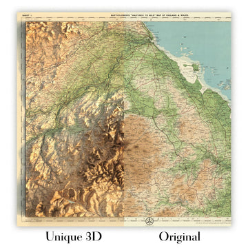
For something truly unique, this map is also available in "Unique 3D", our trademarked process that dramatically transforms the map so that it has a wonderful sense of depth. We combine the original map with detailed topography and elevation data, so that mountains and the terrain really "pop". For more info and examples of 3D maps, check my Unique 3D page.
Many of our maps and art prints are chosen as thoughtful gifts for homes, offices, studies and meaningful places.
Choose a framed option for the easiest ready-to-hang gift, or choose an unframed print if the recipient may prefer to select their own frame.
We make orders locally in 23 countries around the world, so gifts can often be produced close to the recipient. This helps them arrive faster, travel more safely, and avoid customs or import duty surprises.
- We can deliver directly to the recipient
- Framed pieces arrive ready to hang
- Unframed prints are carefully packed in a strong protective tube
- Almost every order is made locally, for faster, safer gifting
- 90-day returns give the recipient time to decide
If you are not sure what to choose, please contact us. We can help you pick the right map, size, finish or delivery option.
Pour la plupart des commandes, le délai de livraison est d'environ 3 jours ouvrables. Les produits personnalisés et sur mesure prennent plus de temps, car je dois faire la personnalisation et vous l'envoyer pour approbation, ce qui prend généralement 1 ou 2 jours.
Veuillez noter que les grandes commandes encadrées prennent généralement plus de temps à réaliser et à livrer.
Si vous avez besoin que votre commande arrive à une date précise, veuillez me contacter avant de passer votre commande afin que nous puissions trouver le meilleur moyen de nous assurer que vous receviez votre commande à temps.
J'imprime et encadre des cartes et des œuvres d'art dans 23 pays à travers le monde. Cela signifie que votre commande sera réalisée localement, ce qui réduit le temps de livraison et garantit qu'elle ne sera pas endommagée pendant le transport. Vous ne paierez jamais de droits de douane ou d'importation, et nous mettrons moins de CO2 dans l'air.
Toutes mes cartes et impressions artistiques sont bien emballées et envoyées dans un tube robuste si non encadrées, ou entourées de mousse si encadrées.
J'essaie d'envoyer toutes les commandes dans les 1 ou 2 jours suivant la réception de votre commande, bien que certains produits (comme les masques, les mugs et les sacs fourre-tout) puissent prendre plus de temps à réaliser.
Si vous choisissez Livraison Express lors du paiement, nous donnerons la priorité à votre commande et l'enverrons par un service de messagerie de 1 jour (Fedex, DHL, UPS, Parcelforce).
La livraison le lendemain est également disponible dans certains pays (États-Unis, Royaume-Uni, Singapour, Émirats Arabes Unis), mais veuillez essayer de commander tôt dans la journée afin que nous puissions l'envoyer à temps.
Lisez mon guide complet sur la livraison et la production locale
Mon cadre standard est un cadre en bois dur noir de style galerie. Il est simple et a un aspect assez moderne. Mon cadre standard mesure environ 20 mm (0,8 po) de large.
J'utilise de l'acrylique super clair (perspex/acrylite) pour le verre du cadre. C'est plus léger et plus sûr que le verre - et cela a meilleur aspect, car la réflexivité est plus faible.
Six couleurs de cadre standard sont disponibles gratuitement (noir, marron foncé, gris foncé, chêne, blanc et or antique). Des encadrements et montages/matelassages personnalisés sont disponibles si vous recherchez autre chose.
La plupart des cartes, œuvres d'art et illustrations sont également disponibles sous forme de toile encadrée. Nous utilisons une toile en coton mate (non brillante), que nous tendons sur un cadre en bois de boîte provenant de sources durables, puis nous 'flottions' la pièce à l'intérieur d'un cadre en bois. Le résultat final est assez beau, et il n'y a pas de vitrage qui gêne.
Tous les cadres sont fournis "prêts à accrocher", avec soit une corde, soit des supports à l'arrière. Les très grands cadres auront des plaques de suspension lourdes et/ou une latte de montage. Si vous avez des questions, veuillez nous contacter.
Voir quelques exemples de mes cartes encadrées et de cartes en toile encadrées.
Alternativement, je peux également fournir de vieilles cartes et œuvres d'art sur toile, sur panneau en mousse, en coton et d'autres matériaux.
Si vous souhaitez encadrer votre carte ou œuvre d'art vous-même, veuillez lire d'abord mon guide des tailles.
Mes cartes sont des reproductions de cartes originales de très haute qualité.
Je recherche des cartes originales et rares auprès de bibliothèques, de maisons de ventes aux enchères et de collections privées du monde entier, je les restaure dans mon atelier de Londres, puis j'utilise des encres et des imprimantes giclées spécialisées pour créer de magnifiques cartes encore plus belles que l'originale.
Mes cartes sont imprimées sur du papier d’archives mat (non brillant) sans acide qui semble de très haute qualité et ressemble presque à une carte. En termes techniques, le grammage/épaisseur du papier est de 10 mil/200 g/m². C'est parfait pour l'encadrement.
J’imprime avec des encres pigmentaires Epson ultrachrome giclée UV résistantes à la décoloration – certaines des meilleures encres que vous puissiez trouver.
je peux aussi faire cartes sur toile, chiffon en coton et autres matériaux exotiques.
En savoir plus sur Unique Maps Co..
Personnalisation de la carte
Si vous recherchez le cadeau parfait pour un anniversaire ou une pendaison de crémaillère, je peux personnaliser votre carte pour la rendre vraiment unique. Par exemple, je peux ajouter un court message, mettre en évidence un lieu important ou ajouter les armoiries de votre famille.
Les options sont presque infinies. S'il vous plaît voir mon page de personnalisation de la carte pour quelques merveilleux exemples de ce qui est possible.
Pour commander une carte personnalisée, sélectionnez « personnaliser votre carte » avant de l'ajouter à votre panier.
Entrer en contact si vous recherchez des personnalisations et des personnalisations plus complexes.
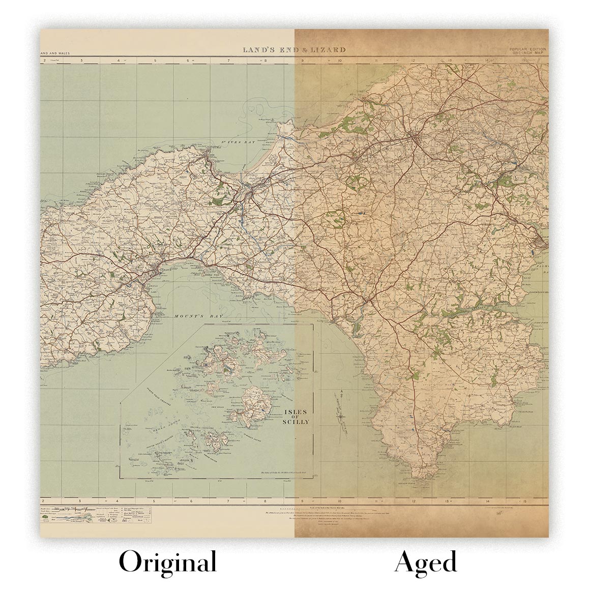
Vieillissement de la carte
Au fil des ans, des clients m'ont demandé des centaines de fois s'ils pouvaient acheter une carte qui semble uniforme. plus vieux.
Eh bien, vous pouvez désormais le faire en sélectionnant Aged avant d'ajouter une carte à votre panier.
Toutes les photos de produits que vous voyez sur cette page montrent la carte dans sa forme originale. Voilà à quoi ressemble la carte aujourd'hui.
Si vous sélectionnez Vieilli, je vieillirai votre carte à la main, en utilisant un processus spécial et unique développé au cours d'années d'étude de cartes anciennes, de discussions avec des chercheurs pour comprendre la chimie du vieillissement du papier, et bien sûr... beaucoup de pratique !
Si vous n'êtes pas sûr, respectez la couleur originale de la carte. Si vous voulez quelque chose d'un peu plus sombre et plus vieux à la recherche, optez pour Aged.
Si vous n'êtes pas satisfait de votre commande pour une raison quelconque, contactez-moi pour un remboursement sans conditions. Veuillez consulter notre politique de retours et de remboursements pour plus d'informations.
Je suis très confiant que vous aimerez votre carte restaurée ou votre impression artistique. Je fais cela depuis 1984. Je suis un vendeur Etsy 5 étoiles. J'ai vendu des dizaines de milliers de cartes et d'impressions artistiques et j'ai plus de 5 000 vrais avis 5 étoiles.
J'utilise un processus unique pour restaurer des cartes et des œuvres d'art qui est extrêmement chronophage et exigeant en main-d'œuvre. Trouver les cartes et illustrations originales peut prendre des mois. J'utilise une technologie de pointe et incroyablement coûteuse pour les numériser et les restaurer. En conséquence, je garantis que mes cartes et impressions artistiques sont d'une qualité supérieure - c'est pourquoi je peux offrir un remboursement sans conditions.
Presque toutes mes cartes et impressions artistiques ont l'air incroyables en grandes tailles (200 cm, 6,5 pieds+) et je peux également les encadrer et vous les livrer, via un transporteur spécial surdimensionné. Contactez-moi pour discuter de vos besoins spécifiques.
Or try searching for something!


