


Ancienne carte des royaumes et comtés saxons en Angleterre et au Pays de Galles par Morden, 1695: Wessex, Mercie, York
20% de réduction sur 2 — 33% de réduction sur 3
Ajoutez n'importe quel deux articles éligibles à votre panier pour recevoir 20% de réduction. Ajoutez un troisième et il sera offert (équivalent à 33% de réduction lors de l'achat de trois).
Aucun code nécessaire — l'offre s'applique automatiquement au moment du paiement.
Valide sur toutes les cartes standard et les impressions d'art. Vous pouvez mélanger et assortir n'importe quel design.
Si vous souhaitez expédier des articles à plusieurs adresses, veuillez nous contacter avant de passer votre commande.
Les commandes personnalisées et sur mesure sont exclues.
Contactez-nous si vous avez des questions
 Conçu à Londres Fabriqué en the USA
Conçu à Londres • Fabriqué en the USA
Conçu à Londres Fabriqué en the USA
Conçu à Londres • Fabriqué en the USA

Choose your size
Choose your finish


(Plus d’infos)
Message cadeau & finition personnalisée

Si vous souhaitez ajouter un message cadeau, ou une finition (puzzle, panneau en aluminium, etc.) qui n'est pas disponible ici, veuillez le demander dans la "note de commande" lors de votre passage à la caisse.
Chaque commande est fabriquée sur mesure, donc si vous avez besoin d'ajuster légèrement la taille, ou d'imprimer sur un matériau inhabituel, faites-le nous savoir. Nous avons réalisé des milliers de commandes personnalisées au fil des ans, donc il n'y a (presque) rien que nous ne puissions gérer.
Vous pouvez également nous contacter avant de passer votre commande, si vous le souhaitez !

- Made locally for fast, safe delivery
- No import duty or hidden fees
- Need advice? Message us on WhatsApp
Own a piece of history
7,000+ 5 star reviews


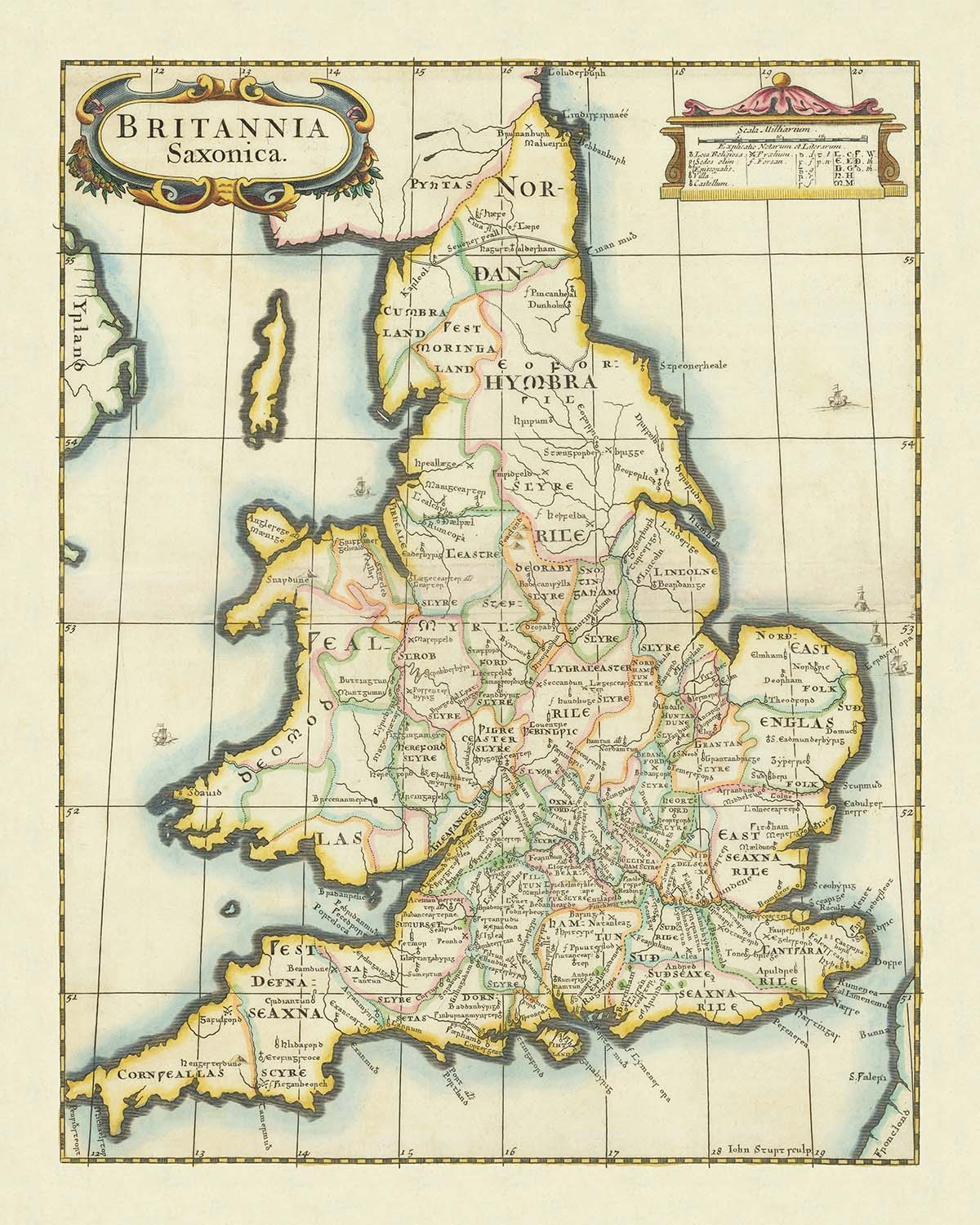
Entrez dans les siècles formatifs de l'histoire anglaise avec "Britannia Saxonica", une carte exquise réalisée par le cartographe réputé Robert Morden en 1695 et méticuleusement gravée par John Sturt. Cette pièce historiquement significative transporte le spectateur à l'époque saxonne, une époque où l'Angleterre et le Pays de Galles étaient un patchwork de puissants royaumes tels que Northumbria, Mercia, Wessex et East Anglia. La carte de Morden n'est pas simplement un document géographique ; c'est un récit visuel de la période médiévale précoce, capturant les frontières changeantes et les paysages culturels qui ont façonné le destin de la Grande-Bretagne.
Le thème de la carte sur l'Angleterre et le Pays de Galles saxons offre un rare aperçu des divisions politiques et des structures administratives qui ont précédé la conquête normande. Chaque royaume est soigneusement délimité, avec des comtés et des régions tracés pour refléter la compréhension historique de la fin du XVIIe siècle. Des lieux notables comme Londres (Lunden), York, Winchester et Canterbury sont élégamment étiquetés dans leurs formes anciennes, invitant le spectateur à imaginer la vie animée et les événements marquants qui se sont déroulés dans ces villes légendaires.
"Britannia Saxonica" est un témoignage de la curiosité antiquaire de son époque, alliant recherche historique méticuleuse et art de la cartographie d'époque. Le cartouche décoratif, la rose des vents et les ornements de bordure complexes illustrent le savoir-faire de Morden et Sturt, tandis que la gravure en monochrome met en évidence l'intention savante de la carte. L'étiquetage dense de la carte et la représentation soignée des rivières, des côtes et des îles - comme l'île de Wight et la Cornouaille - démontrent un dévouement à la précision et au détail qui aurait ravi les collectionneurs et les historiens contemporains.
Historiquement, cette carte occupe une place unique en tant que produit de la fascination moderne précoce pour les origines de l'Angleterre. En reconstruisant les divisions territoriales de la période saxonne, le travail de Morden reflète l'élan du XVIIe siècle pour comprendre et célébrer le passé ancien de la nation. Elle fournit un aperçu inestimable de la façon dont les érudits de l'époque visualisaient la Grande-Bretagne primitive, comblant le fossé entre les chroniques médiévales et l'enquête historique moderne. L'attrait durable de la carte réside dans sa capacité à évoquer un monde perdu de royaumes, d'alliances et de rivalités qui ont jeté les bases de l'Angleterre que nous connaissons aujourd'hui.
Pour les collectionneurs et les passionnés d'histoire britannique, "Britannia Saxonica" est plus qu'un artefact - c'est une invitation à explorer les racines de l'identité anglaise. Les riches détails et la résonance historique de la carte en font une pièce maîtresse de toute collection, offrant une connexion tangible avec les rois légendaires, les batailles épiques et les mythes durables de la Grande-Bretagne saxonne. Qu'elle soit exposée dans un bureau, une bibliothèque ou une galerie, cette carte sert de rappel intemporel des complexités et des merveilles de l'histoire ancienne de l'Angleterre.
Endroits sur cette carte
- Northumbria
- Mercia
- East Anglia
- Essex
- Kent
- Sussex
- Wessex
- Pays de Galles
- Londres (Lunden)
- York (Eboracum)
- Winchester
- Canterbury
- Exeter
- Lincoln
- Norwich
- Oxford
- Gloucester
- Chester
- Île de Wight
- Cornouaille
Caractéristiques et monuments notables
- Le titre de la carte : "Britannia Saxonica" affiché en évidence
- Cartouche décoratif avec le titre de la carte et les détails de publication
- Délégation claire des royaumes saxons
- Frontières des royaumes saxons marquées par des lignes
- Rivières majeures, telles que la Tamise, représentées et étiquetées
- La côte de l'Angleterre et du Pays de Galles soigneusement dessinée
- Comtés au sein des royaumes saxons délimités et étiquetés
- Villes et bourgades historiques, telles que Londres, York et Winchester, marquées
- Barre d'échelle pour la mesure des distances
- Rose des vents indiquant l'orientation
- Éléments décoratifs, tels que des ornements et des enroulements, autour du cartouche et des bordures
- Polices et calligraphie appropriées à la période pour les étiquettes
- Noms de lieux donnés dans leurs formes historiques (par exemple, "Lunden" pour Londres)
- La carte montre l'île de Wight et d'autres îles côtières
- Légende ou clé expliquant les symboles ou les lignes
- La carte est orientée avec le nord en haut
- Bordures de la carte décorées d'une ligne de cadre et d'embellissements
- Gravure monochrome typique de la période
- Quelques anciennes routes ou chemins indiqués faiblement
- La carte est densément étiquetée avec des noms de lieux et des régions
Contexte historique et design
- Créée par Robert Morden, un cartographe anglais notable de la fin du 17e siècle
- Gravée par John Sturt, un graveur talentueux de l'époque
- Date de création : 1695
- La carte représente les royaumes et comtés de l'Angleterre saxonne et du Pays de Galles, illustrant les divisions territoriales avant la Conquête normande
- La carte fournit une représentation visuelle du paysage politique pendant l'ère saxonne, y compris les emplacements et les frontières des principaux royaumes
- Le design présente des cartouches décoratifs et des ornements artistiques typiques de la période, communs dans la cartographie anglaise de la fin du 17e siècle
- La carte est historiquement significative pour sa tentative de reconstruire la géographie de la Grande-Bretagne médiévale précoce basée sur les sources historiques disponibles
- Destinée à un public éducatif et antiquaire intéressé par l'histoire et les origines des comtés et royaumes anglais
- Réflecte l'intérêt contemporain du 17e siècle pour les origines de l'identité anglaise et l'héritage des Saxons
- Fournit un aperçu de la manière dont les érudits de la fin du 17e siècle comprenaient et visualisaient le passé médiéval précoce
- Une ressource précieuse pour les historiens étudiant la perception et la représentation de l'Angleterre saxonne dans les siècles suivants
- Partie d'une tendance plus large dans l'Angleterre moderne précoce à documenter et célébrer l'histoire ancienne de la nation
- L'inclusion à la fois des royaumes et des comtés montre la transition des divisions administratives médiévales précoces aux divisions administratives ultérieures
- Un exemple de la fusion de la recherche historique et de la cartographie artistique dans la période moderne précoce
Veuillez vérifier les images pour vous assurer qu'une ville ou un lieu spécifique est représenté sur cette carte. Vous pouvez également nous contacter et nous demander de vérifier la carte pour vous.
Cette carte a fière allure à toutes les tailles, mais je recommande toujours d'opter pour une taille plus grande si vous avez de l'espace. De cette façon, vous pouvez facilement distinguer tous les détails.
Cette carte est incroyable à des tailles allant jusqu'à 70 pouces (180 cm). Si vous recherchez une carte plus grande, veuillez nous contacter.
Le modèle dans les images de la liste tient la version de cette carte de 16x20 pouces (40x50 cm).
La cinquième image de la liste montre un exemple de mon service de personnalisation de carte.
Si vous recherchez quelque chose de légèrement différent, consultez ma collection des meilleures anciennes cartes pour voir si quelque chose d'autre attire votre attention.
Veuillez me contacter pour vérifier si un certain emplacement, monument ou caractéristique est présent sur cette carte.
Cela ferait un merveilleux cadeau d'anniversaire, de Noël, pour la fête des pères, pour un départ au travail, un anniversaire de mariage ou une pendaison de crémaillère pour quelqu'un des zones couvertes par cette carte.
Cette carte est disponible en tant qu'impression giclée sur papier mat archivé sans acide, ou vous pouvez l'acheter encadrée. Le cadre est un joli cadre noir simple qui convient à la plupart des esthétiques. Veuillez me contacter si vous souhaitez une couleur ou un matériau de cadre différent. Mes cadres sont vitrifiés avec un acrylique de musée super clair (perspex/acrylite), qui est significativement moins réfléchissant que le verre, plus sûr, et arrivera toujours en parfait état.
This map is also available as a float framed canvas, sometimes known as a shadow gap framed canvas or canvas floater. The map is printed on artist's cotton canvas and then stretched over a handmade box frame. We then "float" the canvas inside a wooden frame, which is available in a range of colours (black, dark brown, oak, antique gold and white). This is a wonderful way to present a map without glazing in front. See some examples of float framed canvas maps and explore the differences between my different finishes.
For something truly unique, this map is also available in "Unique 3D", our trademarked process that dramatically transforms the map so that it has a wonderful sense of depth. We combine the original map with detailed topography and elevation data, so that mountains and the terrain really "pop". For more info and examples of 3D maps, check my Unique 3D page.
Many of our maps and art prints are chosen as thoughtful gifts for homes, offices, studies and meaningful places.
Choose a framed option for the easiest ready-to-hang gift, or choose an unframed print if the recipient may prefer to select their own frame.
We make orders locally in 23 countries around the world, so gifts can often be produced close to the recipient. This helps them arrive faster, travel more safely, and avoid customs or import duty surprises.
- We can deliver directly to the recipient
- Framed pieces arrive ready to hang
- Unframed prints are carefully packed in a strong protective tube
- Almost every order is made locally, for faster, safer gifting
- 90-day returns give the recipient time to decide
If you are not sure what to choose, please contact us. We can help you pick the right map, size, finish or delivery option.
Pour la plupart des commandes, le délai de livraison est d'environ 3 jours ouvrables. Les produits personnalisés et sur mesure prennent plus de temps, car je dois faire la personnalisation et vous l'envoyer pour approbation, ce qui prend généralement 1 ou 2 jours.
Veuillez noter que les grandes commandes encadrées prennent généralement plus de temps à réaliser et à livrer.
Si vous avez besoin que votre commande arrive à une date précise, veuillez me contacter avant de passer votre commande afin que nous puissions trouver le meilleur moyen de nous assurer que vous receviez votre commande à temps.
J'imprime et encadre des cartes et des œuvres d'art dans 23 pays à travers le monde. Cela signifie que votre commande sera réalisée localement, ce qui réduit le temps de livraison et garantit qu'elle ne sera pas endommagée pendant le transport. Vous ne paierez jamais de droits de douane ou d'importation, et nous mettrons moins de CO2 dans l'air.
Toutes mes cartes et impressions artistiques sont bien emballées et envoyées dans un tube robuste si non encadrées, ou entourées de mousse si encadrées.
J'essaie d'envoyer toutes les commandes dans les 1 ou 2 jours suivant la réception de votre commande, bien que certains produits (comme les masques, les mugs et les sacs fourre-tout) puissent prendre plus de temps à réaliser.
Si vous choisissez Livraison Express lors du paiement, nous donnerons la priorité à votre commande et l'enverrons par un service de messagerie de 1 jour (Fedex, DHL, UPS, Parcelforce).
La livraison le lendemain est également disponible dans certains pays (États-Unis, Royaume-Uni, Singapour, Émirats Arabes Unis), mais veuillez essayer de commander tôt dans la journée afin que nous puissions l'envoyer à temps.
Lisez mon guide complet sur la livraison et la production locale
Mon cadre standard est un cadre en bois dur noir de style galerie. Il est simple et a un aspect assez moderne. Mon cadre standard mesure environ 20 mm (0,8 po) de large.
J'utilise de l'acrylique super clair (perspex/acrylite) pour le verre du cadre. C'est plus léger et plus sûr que le verre - et cela a meilleur aspect, car la réflexivité est plus faible.
Six couleurs de cadre standard sont disponibles gratuitement (noir, marron foncé, gris foncé, chêne, blanc et or antique). Des encadrements et montages/matelassages personnalisés sont disponibles si vous recherchez autre chose.
La plupart des cartes, œuvres d'art et illustrations sont également disponibles sous forme de toile encadrée. Nous utilisons une toile en coton mate (non brillante), que nous tendons sur un cadre en bois de boîte provenant de sources durables, puis nous 'flottions' la pièce à l'intérieur d'un cadre en bois. Le résultat final est assez beau, et il n'y a pas de vitrage qui gêne.
Tous les cadres sont fournis "prêts à accrocher", avec soit une corde, soit des supports à l'arrière. Les très grands cadres auront des plaques de suspension lourdes et/ou une latte de montage. Si vous avez des questions, veuillez nous contacter.
Voir quelques exemples de mes cartes encadrées et de cartes en toile encadrées.
Alternativement, je peux également fournir de vieilles cartes et œuvres d'art sur toile, sur panneau en mousse, en coton et d'autres matériaux.
Si vous souhaitez encadrer votre carte ou œuvre d'art vous-même, veuillez lire d'abord mon guide des tailles.
Mes cartes sont des reproductions de cartes originales de très haute qualité.
Je recherche des cartes originales et rares auprès de bibliothèques, de maisons de ventes aux enchères et de collections privées du monde entier, je les restaure dans mon atelier de Londres, puis j'utilise des encres et des imprimantes giclées spécialisées pour créer de magnifiques cartes encore plus belles que l'originale.
Mes cartes sont imprimées sur du papier d’archives mat (non brillant) sans acide qui semble de très haute qualité et ressemble presque à une carte. En termes techniques, le grammage/épaisseur du papier est de 10 mil/200 g/m². C'est parfait pour l'encadrement.
J’imprime avec des encres pigmentaires Epson ultrachrome giclée UV résistantes à la décoloration – certaines des meilleures encres que vous puissiez trouver.
je peux aussi faire cartes sur toile, chiffon en coton et autres matériaux exotiques.
En savoir plus sur Unique Maps Co..
Personnalisation de la carte
Si vous recherchez le cadeau parfait pour un anniversaire ou une pendaison de crémaillère, je peux personnaliser votre carte pour la rendre vraiment unique. Par exemple, je peux ajouter un court message, mettre en évidence un lieu important ou ajouter les armoiries de votre famille.
Les options sont presque infinies. S'il vous plaît voir mon page de personnalisation de la carte pour quelques merveilleux exemples de ce qui est possible.
Pour commander une carte personnalisée, sélectionnez « personnaliser votre carte » avant de l'ajouter à votre panier.
Entrer en contact si vous recherchez des personnalisations et des personnalisations plus complexes.
Vieillissement de la carte
Au fil des ans, des clients m'ont demandé des centaines de fois s'ils pouvaient acheter une carte qui semble uniforme. plus vieux.
Eh bien, vous pouvez désormais le faire en sélectionnant Aged avant d'ajouter une carte à votre panier.
Toutes les photos de produits que vous voyez sur cette page montrent la carte dans sa forme originale. Voilà à quoi ressemble la carte aujourd'hui.
Si vous sélectionnez Vieilli, je vieillirai votre carte à la main, en utilisant un processus spécial et unique développé au cours d'années d'étude de cartes anciennes, de discussions avec des chercheurs pour comprendre la chimie du vieillissement du papier, et bien sûr... beaucoup de pratique !
Si vous n'êtes pas sûr, respectez la couleur originale de la carte. Si vous voulez quelque chose d'un peu plus sombre et plus vieux à la recherche, optez pour Aged.
Si vous n'êtes pas satisfait de votre commande pour une raison quelconque, contactez-moi pour un remboursement sans conditions. Veuillez consulter notre politique de retours et de remboursements pour plus d'informations.
Je suis très confiant que vous aimerez votre carte restaurée ou votre impression artistique. Je fais cela depuis 1984. Je suis un vendeur Etsy 5 étoiles. J'ai vendu des dizaines de milliers de cartes et d'impressions artistiques et j'ai plus de 5 000 vrais avis 5 étoiles.
J'utilise un processus unique pour restaurer des cartes et des œuvres d'art qui est extrêmement chronophage et exigeant en main-d'œuvre. Trouver les cartes et illustrations originales peut prendre des mois. J'utilise une technologie de pointe et incroyablement coûteuse pour les numériser et les restaurer. En conséquence, je garantis que mes cartes et impressions artistiques sont d'une qualité supérieure - c'est pourquoi je peux offrir un remboursement sans conditions.
Presque toutes mes cartes et impressions artistiques ont l'air incroyables en grandes tailles (200 cm, 6,5 pieds+) et je peux également les encadrer et vous les livrer, via un transporteur spécial surdimensionné. Contactez-moi pour discuter de vos besoins spécifiques.
Or try searching for something!


