


Ancienne carte ferroviaire de Grande-Bretagne par Tallis, 1850: Londres, Liverpool, Manchester, routes de bateaux à vapeur, bordures ornées
20% de réduction sur 2 — 33% de réduction sur 3
Ajoutez n'importe quel deux articles éligibles à votre panier pour recevoir 20% de réduction. Ajoutez un troisième et il sera offert (équivalent à 33% de réduction lors de l'achat de trois).
Aucun code nécessaire — l'offre s'applique automatiquement au moment du paiement.
Valide sur toutes les cartes standard et les impressions d'art. Vous pouvez mélanger et assortir n'importe quel design.
Si vous souhaitez expédier des articles à plusieurs adresses, veuillez nous contacter avant de passer votre commande.
Les commandes personnalisées et sur mesure sont exclues.
Contactez-nous si vous avez des questions
 Conçu à Londres Fabriqué en the USA
Conçu à Londres • Fabriqué en the USA
Conçu à Londres Fabriqué en the USA
Conçu à Londres • Fabriqué en the USA

Restaurée à partir de la carte originale de 1850 et imprimée en qualité musée. Lire l’histoire de cette carte
Choose your size
Choose your finish


(Plus d’infos)
Message cadeau & finition personnalisée

Si vous souhaitez ajouter un message cadeau, ou une finition (puzzle, panneau en aluminium, etc.) qui n'est pas disponible ici, veuillez le demander dans la "note de commande" lors de votre passage à la caisse.
Chaque commande est fabriquée sur mesure, donc si vous avez besoin d'ajuster légèrement la taille, ou d'imprimer sur un matériau inhabituel, faites-le nous savoir. Nous avons réalisé des milliers de commandes personnalisées au fil des ans, donc il n'y a (presque) rien que nous ne puissions gérer.
Vous pouvez également nous contacter avant de passer votre commande, si vous le souhaitez !

- Fabriqué localement. Livraison sûre
- Sans droits ni frais cachés
- Besoin d’aide ? Appelez-nous ou message WhatsApp
Own a piece of history
8,000+ five-star reviews


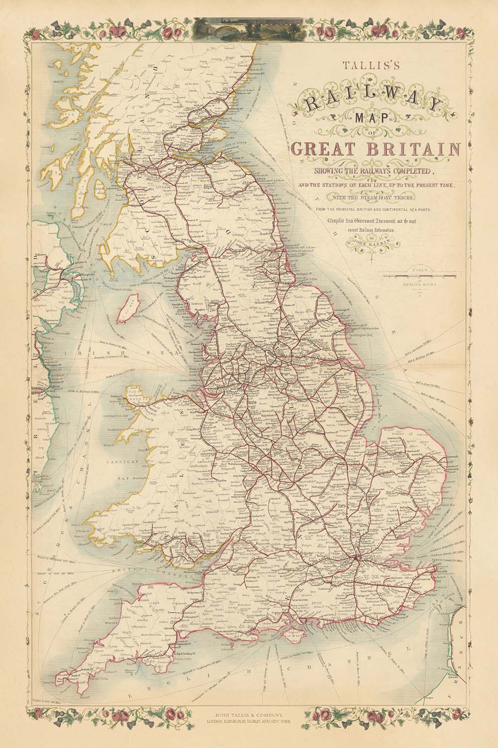
Entrez dans le monde dynamique de la Grande-Bretagne victorienne avec « La carte ferroviaire de Tallis de la Grande-Bretagne montrant les chemins...
Continuer la lectureEntrez dans le monde dynamique de la Grande-Bretagne victorienne avec « La carte ferroviaire de Tallis de la Grande-Bretagne montrant les chemins de fer achevés et les stations sur chaque ligne, jusqu'à ce jour, avec les voies de bateau à vapeur des principaux ports britanniques et continentaux. » Conçue en 1850 par le célèbre éditeur John Tallis et le graveur talentueux John Rapkin, cette carte témoigne du rythme effréné d'innovation et de connectivité de l'époque. D'un coup d'œil, elle révèle la toile complexe des chemins de fer qui ont transformé le paysage, reliant les grandes villes et les bourgs d'Angleterre, d'Écosse et du Pays de Galles pendant le zénith de la Révolution industrielle.
John Tallis, renommé pour ses œuvres cartographiques élégantes et décoratives, a doté cette carte d'un sens de la grandeur et de la clarté. En collaborant avec John Rapkin, dont la gravure méticuleuse a donné vie aux détails, Tallis a veillé à ce que chaque ligne et chaque station soient non seulement précises—soigneusement compilées à partir de documents gouvernementaux et des dernières informations ferroviaires—mais aussi visuellement captivantes. La bordure ornée de la carte est magnifique.
Le focus thématique de la carte sur les chemins de fer et les routes de bateau à vapeur encapsule les changements profonds du milieu du XIXe siècle. Les grandes lignes ferroviaires rayonnent depuis Londres, Birmingham, Manchester et Glasgow, reliant les centres industriels en plein essor aux ports côtiers et aux arrière-pays ruraux. Les voies de bateau à vapeur s'arquent à travers la mer du Nord, la Manche et la mer d'Irlande, reliant les ports britanniques à l'Europe continentale et soulignant la portée mondiale du commerce britannique. Chaque station de chemin de fer et chaque route est soigneusement marquée, offrant un aperçu d'un pays en pleine mobilité et transformation économique sans précédent.
Au-delà de ses réseaux de transport, la carte est une célébration de la géographie riche et variée de la Grande-Bretagne. Les collines ondulantes du Pays de Galles, les Highlands escarpés d'Écosse et les plaines fertiles d'Angleterre sont tous subtilement suggérés, tandis que de grands fleuves comme la Tamise, la Severn et le Clyde tracent leur chemin à travers le paysage. Des illustrations décoratives évoquent l'esprit de l'époque : de puissants ponts, des ports animés et la fière figure de Britannia, le tout sur fond de beauté naturelle et de prouesse industrielle. Les frontières entre l'Angleterre, l'Écosse et le Pays de Galles sont clairement délimitées, et les limites des comtés offrent un aperçu supplémentaire du paysage administratif de l'époque.
Cette carte est plus qu'un simple outil de navigation ; c'est un document historique qui capture l'essence d'une nation en mouvement. Elle retrace l'essor de villes telles que Londres, Birmingham, Liverpool et Glasgow—aujourd'hui des métropoles mondiales—et enregistre les noms de villes et de régions qui ont façonné l'identité britannique pendant des siècles. Qu'elle soit admirée pour son art, son importance historique ou son ambition, cette carte invite le spectateur à voyager dans un moment charnière de l'histoire de la Grande-Bretagne, lorsque les rails de fer et la puissance de la vapeur redessinaient les contours de la vie quotidienne.
Villes et bourgs sur cette carte
-
Angleterre
- Londres
- Birmingham
- Manchester
- Liverpool
- Leeds
- Sheffield
- Newcastle (Newcastle upon Tyne)
- Bristol
- Nottingham
- Leicester
- Portsmouth
- Southampton
- Derby
- York
- Norwich
- Exeter
- Carlisle
- Plymouth
- Hull (Kingston upon Hull)
- Sunderland
- Wolverhampton
- Stoke (Stoke-on-Trent)
- Preston
- Lancaster
- Chester
- Bath
- Oxford
- Cambridge
- Brighton
-
Écosse
- Glasgow
- Édimbourg
- Aberdeen
- Dundee
- Inverness
- Perth
- Stirling
-
Pays de Galles
- Cardiff
- Swansea
- Newport
- Bangor
- Wrexham
Caractéristiques et monuments notables
- Bord décoratif : Bord orné, floral et enroulé entourant la carte, typique des publications de Tallis
- Corps d'eau :
- La mer du Nord (étiquetée comme Océan Allemand)
- La Manche
- La mer d'Irlande
- Différents estuaires et firths (par exemple, Firth of Forth, Solway Firth)
- Frontières :
- Frontières clairement délimitées entre l'Angleterre, l'Écosse et le Pays de Galles
- Limites des comtés dans chaque pays
- Traces de bateaux à vapeur : Lignes en pointillé ou mises en évidence à travers la mer, reliant les ports britanniques aux destinations continentales
- Chemins de fer : Lignes de chemin de fer marquées de manière proéminente traversant le pays, avec des stations indiquées
- Montagnes et terrain : Terrain vallonné et montagneux indiqué, en particulier en Écosse et au Pays de Galles, bien que stylisé plutôt que topographiquement précis
- Les grandes rivières (par exemple, la Tamise, la Severn, la Mersey, le Clyde) sont étiquetées
Contexte historique et de conception
- Créé en 1850, au sommet de la Révolution industrielle
- Publié par John Tallis, un éditeur renommé du 19ème siècle connu pour ses cartes élégantes et décoratives
- Cartographie par John Rapkin, un graveur talentueux et collaborateur fréquent de Tallis
- Accent thématique sur l'infrastructure ferroviaire et les routes des bateaux à vapeur, reflétant la transformation industrielle et socio-économique rapide de la Grande-Bretagne
- Minutieusement compilé à partir de documents gouvernementaux et des dernières informations ferroviaires de l'époque
- Capture l'expansion des chemins de fer britanniques et l'augmentation de la mobilité nationale
- Bordures décoratives et illustrations gravées améliorent à la fois l'attrait visuel et la valeur historique
- Servir de source principale pour comprendre le transport et la géographie britannique du milieu du 19ème siècle
- Offre un aperçu du paysage administratif avec des limites de comté clairement marquées
Veuillez vérifier les images pour vous assurer qu'une ville ou un lieu spécifique est représenté sur cette carte. Vous pouvez également nous contacter et nous demander de vérifier la carte pour vous.
Cette carte est magnifique à toutes les tailles, mais je recommande toujours d'opter pour une taille plus grande si vous avez de l'espace. De cette façon, vous pouvez facilement distinguer tous les détails.
Cette carte est incroyable à des tailles allant jusqu'à 90in (230cm). Si vous cherchez une carte plus grande, veuillez nous contacter.
Veuillez noter : les étiquettes sur cette carte sont difficiles à lire si vous commandez une carte de 16in (40cm) ou plus petite. La carte est toujours très attrayante, mais si vous souhaitez lire la carte facilement, veuillez acheter une taille plus grande.
Le modèle sur les images de la liste tient la version 24x36in (60x90cm) de cette carte.
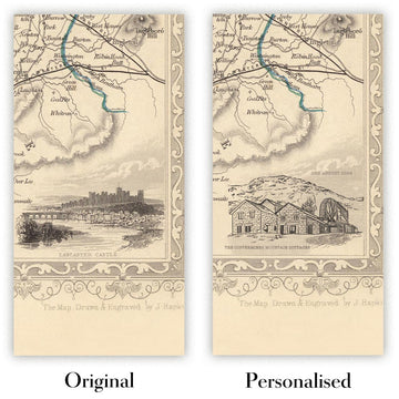
La cinquième image de la liste montre un exemple de mon service de personnalisation de carte.
Si vous cherchez quelque chose de légèrement différent, consultez ma collection des meilleures anciennes cartes pour voir si quelque chose d'autre attire votre attention.
Veuillez me contacter pour vérifier si un certain emplacement, monument ou caractéristique est représenté sur cette carte.
Cela ferait un merveilleux cadeau d'anniversaire, de Noël, pour la fête des pères, pour un départ au travail, un anniversaire de mariage ou une pendaison de crémaillère pour quelqu'un des zones couvertes par cette carte.
Cette carte est disponible en tant qu'impression giclée sur papier mat d'archives sans acide, ou vous pouvez l'acheter encadrée. Le cadre est un joli cadre noir simple qui convient à la plupart des esthétiques. N'hésitez pas à me contacter si vous souhaitez une couleur ou un matériau de cadre différent. Mes cadres sont vitrées avec un acrylique de musée super clair (perspex/acrylite), qui est significativement moins réfléchissant que le verre, plus sûr, et arrivera toujours en parfait état.
This map is also available as a float framed canvas, sometimes known as a shadow gap framed canvas or canvas floater. The map is printed on artist's cotton canvas and then stretched over a handmade box frame. We then "float" the canvas inside a wooden frame, which is available in a range of colours (black, dark brown, oak, antique gold and white). This is a wonderful way to present a map without glazing in front. See some examples of float framed canvas maps and explore the differences between my different finishes.
For something truly unique, this map is also available in "Unique 3D", our trademarked process that dramatically transforms the map so that it has a wonderful sense of depth. We combine the original map with detailed topography and elevation data, so that mountains and the terrain really "pop". For more info and examples of 3D maps, check my Unique 3D page.
Entrez dans le monde dynamique de la Grande-Bretagne victorienne avec « La carte ferroviaire de Tallis de la Grande-Bretagne montrant les chemins de fer achevés et les stations sur chaque ligne, jusqu'à ce jour, avec les voies de bateau à vapeur des principaux ports britanniques et continentaux. » Conçue en 1850 par le célèbre éditeur John Tallis et le graveur talentueux John Rapkin, cette carte témoigne du rythme effréné d'innovation et de connectivité de l'époque. D'un coup d'œil, elle révèle la toile complexe des chemins de fer qui ont transformé le paysage, reliant les grandes villes et les bourgs d'Angleterre, d'Écosse et du Pays de Galles pendant le zénith de la Révolution industrielle.
John Tallis, renommé pour ses œuvres cartographiques élégantes et décoratives, a doté cette carte d'un sens de la grandeur et de la clarté. En collaborant avec John Rapkin, dont la gravure méticuleuse a donné vie aux détails, Tallis a veillé à ce que chaque ligne et chaque station soient non seulement précises—soigneusement compilées à partir de documents gouvernementaux et des dernières informations ferroviaires—mais aussi visuellement captivantes. La bordure ornée de la carte est magnifique.
Le focus thématique de la carte sur les chemins de fer et les routes de bateau à vapeur encapsule les changements profonds du milieu du XIXe siècle. Les grandes lignes ferroviaires rayonnent depuis Londres, Birmingham, Manchester et Glasgow, reliant les centres industriels en plein essor aux ports côtiers et aux arrière-pays ruraux. Les voies de bateau à vapeur s'arquent à travers la mer du Nord, la Manche et la mer d'Irlande, reliant les ports britanniques à l'Europe continentale et soulignant la portée mondiale du commerce britannique. Chaque station de chemin de fer et chaque route est soigneusement marquée, offrant un aperçu d'un pays en pleine mobilité et transformation économique sans précédent.
Au-delà de ses réseaux de transport, la carte est une célébration de la géographie riche et variée de la Grande-Bretagne. Les collines ondulantes du Pays de Galles, les Highlands escarpés d'Écosse et les plaines fertiles d'Angleterre sont tous subtilement suggérés, tandis que de grands fleuves comme la Tamise, la Severn et le Clyde tracent leur chemin à travers le paysage. Des illustrations décoratives évoquent l'esprit de l'époque : de puissants ponts, des ports animés et la fière figure de Britannia, le tout sur fond de beauté naturelle et de prouesse industrielle. Les frontières entre l'Angleterre, l'Écosse et le Pays de Galles sont clairement délimitées, et les limites des comtés offrent un aperçu supplémentaire du paysage administratif de l'époque.
Cette carte est plus qu'un simple outil de navigation ; c'est un document historique qui capture l'essence d'une nation en mouvement. Elle retrace l'essor de villes telles que Londres, Birmingham, Liverpool et Glasgow—aujourd'hui des métropoles mondiales—et enregistre les noms de villes et de régions qui ont façonné l'identité britannique pendant des siècles. Qu'elle soit admirée pour son art, son importance historique ou son ambition, cette carte invite le spectateur à voyager dans un moment charnière de l'histoire de la Grande-Bretagne, lorsque les rails de fer et la puissance de la vapeur redessinaient les contours de la vie quotidienne.
Villes et bourgs sur cette carte
-
Angleterre
- Londres
- Birmingham
- Manchester
- Liverpool
- Leeds
- Sheffield
- Newcastle (Newcastle upon Tyne)
- Bristol
- Nottingham
- Leicester
- Portsmouth
- Southampton
- Derby
- York
- Norwich
- Exeter
- Carlisle
- Plymouth
- Hull (Kingston upon Hull)
- Sunderland
- Wolverhampton
- Stoke (Stoke-on-Trent)
- Preston
- Lancaster
- Chester
- Bath
- Oxford
- Cambridge
- Brighton
-
Écosse
- Glasgow
- Édimbourg
- Aberdeen
- Dundee
- Inverness
- Perth
- Stirling
-
Pays de Galles
- Cardiff
- Swansea
- Newport
- Bangor
- Wrexham
Caractéristiques et monuments notables
- Bord décoratif : Bord orné, floral et enroulé entourant la carte, typique des publications de Tallis
- Corps d'eau :
- La mer du Nord (étiquetée comme Océan Allemand)
- La Manche
- La mer d'Irlande
- Différents estuaires et firths (par exemple, Firth of Forth, Solway Firth)
- Frontières :
- Frontières clairement délimitées entre l'Angleterre, l'Écosse et le Pays de Galles
- Limites des comtés dans chaque pays
- Traces de bateaux à vapeur : Lignes en pointillé ou mises en évidence à travers la mer, reliant les ports britanniques aux destinations continentales
- Chemins de fer : Lignes de chemin de fer marquées de manière proéminente traversant le pays, avec des stations indiquées
- Montagnes et terrain : Terrain vallonné et montagneux indiqué, en particulier en Écosse et au Pays de Galles, bien que stylisé plutôt que topographiquement précis
- Les grandes rivières (par exemple, la Tamise, la Severn, la Mersey, le Clyde) sont étiquetées
Contexte historique et de conception
- Créé en 1850, au sommet de la Révolution industrielle
- Publié par John Tallis, un éditeur renommé du 19ème siècle connu pour ses cartes élégantes et décoratives
- Cartographie par John Rapkin, un graveur talentueux et collaborateur fréquent de Tallis
- Accent thématique sur l'infrastructure ferroviaire et les routes des bateaux à vapeur, reflétant la transformation industrielle et socio-économique rapide de la Grande-Bretagne
- Minutieusement compilé à partir de documents gouvernementaux et des dernières informations ferroviaires de l'époque
- Capture l'expansion des chemins de fer britanniques et l'augmentation de la mobilité nationale
- Bordures décoratives et illustrations gravées améliorent à la fois l'attrait visuel et la valeur historique
- Servir de source principale pour comprendre le transport et la géographie britannique du milieu du 19ème siècle
- Offre un aperçu du paysage administratif avec des limites de comté clairement marquées
Veuillez vérifier les images pour vous assurer qu'une ville ou un lieu spécifique est représenté sur cette carte. Vous pouvez également nous contacter et nous demander de vérifier la carte pour vous.
Cette carte est magnifique à toutes les tailles, mais je recommande toujours d'opter pour une taille plus grande si vous avez de l'espace. De cette façon, vous pouvez facilement distinguer tous les détails.
Cette carte est incroyable à des tailles allant jusqu'à 90in (230cm). Si vous cherchez une carte plus grande, veuillez nous contacter.
Veuillez noter : les étiquettes sur cette carte sont difficiles à lire si vous commandez une carte de 16in (40cm) ou plus petite. La carte est toujours très attrayante, mais si vous souhaitez lire la carte facilement, veuillez acheter une taille plus grande.
Le modèle sur les images de la liste tient la version 24x36in (60x90cm) de cette carte.
La cinquième image de la liste montre un exemple de mon service de personnalisation de carte.
Si vous cherchez quelque chose de légèrement différent, consultez ma collection des meilleures anciennes cartes pour voir si quelque chose d'autre attire votre attention.
Veuillez me contacter pour vérifier si un certain emplacement, monument ou caractéristique est représenté sur cette carte.
Cela ferait un merveilleux cadeau d'anniversaire, de Noël, pour la fête des pères, pour un départ au travail, un anniversaire de mariage ou une pendaison de crémaillère pour quelqu'un des zones couvertes par cette carte.
Cette carte est disponible en tant qu'impression giclée sur papier mat d'archives sans acide, ou vous pouvez l'acheter encadrée. Le cadre est un joli cadre noir simple qui convient à la plupart des esthétiques. N'hésitez pas à me contacter si vous souhaitez une couleur ou un matériau de cadre différent. Mes cadres sont vitrées avec un acrylique de musée super clair (perspex/acrylite), qui est significativement moins réfléchissant que le verre, plus sûr, et arrivera toujours en parfait état.
This map is also available as a float framed canvas, sometimes known as a shadow gap framed canvas or canvas floater. The map is printed on artist's cotton canvas and then stretched over a handmade box frame. We then "float" the canvas inside a wooden frame, which is available in a range of colours (black, dark brown, oak, antique gold and white). This is a wonderful way to present a map without glazing in front. See some examples of float framed canvas maps and explore the differences between my different finishes.
For something truly unique, this map is also available in "Unique 3D", our trademarked process that dramatically transforms the map so that it has a wonderful sense of depth. We combine the original map with detailed topography and elevation data, so that mountains and the terrain really "pop". For more info and examples of 3D maps, check my Unique 3D page.
Many of our maps and art prints are chosen as thoughtful gifts for homes, offices, studies and meaningful places.
Choose a framed option for the easiest ready-to-hang gift, or choose an unframed print if the recipient may prefer to select their own frame.
We make orders locally in 23 countries around the world, so gifts can often be produced close to the recipient. This helps them arrive faster, travel more safely, and avoid customs or import duty surprises.
- We can deliver directly to the recipient
- Framed pieces arrive ready to hang
- Unframed prints are carefully packed in a strong protective tube
- Almost every order is made locally, for faster, safer gifting
- 90-day returns give the recipient time to decide
If you are not sure what to choose, please contact us. We can help you pick the right map, size, finish or delivery option.
Pour la plupart des commandes, le délai de livraison est d'environ 3 jours ouvrables. Les produits personnalisés et sur mesure prennent plus de temps, car je dois faire la personnalisation et vous l'envoyer pour approbation, ce qui prend généralement 1 ou 2 jours.
Veuillez noter que les grandes commandes encadrées prennent généralement plus de temps à réaliser et à livrer.
Si vous avez besoin que votre commande arrive à une date précise, veuillez me contacter avant de passer votre commande afin que nous puissions trouver le meilleur moyen de nous assurer que vous receviez votre commande à temps.
J'imprime et encadre des cartes et des œuvres d'art dans 23 pays à travers le monde. Cela signifie que votre commande sera réalisée localement, ce qui réduit le temps de livraison et garantit qu'elle ne sera pas endommagée pendant le transport. Vous ne paierez jamais de droits de douane ou d'importation, et nous mettrons moins de CO2 dans l'air.
Toutes mes cartes et impressions artistiques sont bien emballées et envoyées dans un tube robuste si non encadrées, ou entourées de mousse si encadrées.
J'essaie d'envoyer toutes les commandes dans les 1 ou 2 jours suivant la réception de votre commande, bien que certains produits (comme les masques, les mugs et les sacs fourre-tout) puissent prendre plus de temps à réaliser.
Si vous choisissez Livraison Express lors du paiement, nous donnerons la priorité à votre commande et l'enverrons par un service de messagerie de 1 jour (Fedex, DHL, UPS, Parcelforce).
La livraison le lendemain est également disponible dans certains pays (États-Unis, Royaume-Uni, Singapour, Émirats Arabes Unis), mais veuillez essayer de commander tôt dans la journée afin que nous puissions l'envoyer à temps.
Lisez mon guide complet sur la livraison et la production locale
Mon cadre standard est un cadre en bois dur noir de style galerie. Il est simple et a un aspect assez moderne. Mon cadre standard mesure environ 20 mm (0,8 po) de large.
J'utilise de l'acrylique super clair (perspex/acrylite) pour le verre du cadre. C'est plus léger et plus sûr que le verre - et cela a meilleur aspect, car la réflexivité est plus faible.
Six couleurs de cadre standard sont disponibles gratuitement (noir, marron foncé, gris foncé, chêne, blanc et or antique). Des encadrements et montages/matelassages personnalisés sont disponibles si vous recherchez autre chose.
La plupart des cartes, œuvres d'art et illustrations sont également disponibles sous forme de toile encadrée. Nous utilisons une toile en coton mate (non brillante), que nous tendons sur un cadre en bois de boîte provenant de sources durables, puis nous 'flottions' la pièce à l'intérieur d'un cadre en bois. Le résultat final est assez beau, et il n'y a pas de vitrage qui gêne.
Tous les cadres sont fournis "prêts à accrocher", avec soit une corde, soit des supports à l'arrière. Les très grands cadres auront des plaques de suspension lourdes et/ou une latte de montage. Si vous avez des questions, veuillez nous contacter.
Voir quelques exemples de mes cartes encadrées et de cartes en toile encadrées.
Alternativement, je peux également fournir de vieilles cartes et œuvres d'art sur toile, sur panneau en mousse, en coton et d'autres matériaux.
Si vous souhaitez encadrer votre carte ou œuvre d'art vous-même, veuillez lire d'abord mon guide des tailles.
Mes cartes sont des reproductions de cartes originales de très haute qualité.
Je recherche des cartes originales et rares auprès de bibliothèques, de maisons de ventes aux enchères et de collections privées du monde entier, je les restaure dans mon atelier de Londres, puis j'utilise des encres et des imprimantes giclées spécialisées pour créer de magnifiques cartes encore plus belles que l'originale.
Mes cartes sont imprimées sur du papier d’archives mat (non brillant) sans acide qui semble de très haute qualité et ressemble presque à une carte. En termes techniques, le grammage/épaisseur du papier est de 10 mil/200 g/m². C'est parfait pour l'encadrement.
J’imprime avec des encres pigmentaires Epson ultrachrome giclée UV résistantes à la décoloration – certaines des meilleures encres que vous puissiez trouver.
je peux aussi faire cartes sur toile, chiffon en coton et autres matériaux exotiques.
En savoir plus sur Unique Maps Co..
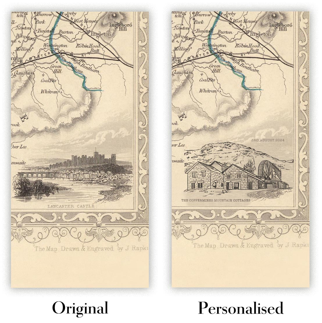
Personnalisation de la carte
Si vous recherchez le cadeau parfait pour un anniversaire ou une pendaison de crémaillère, je peux personnaliser votre carte pour la rendre vraiment unique. Par exemple, je peux ajouter un court message, mettre en évidence un lieu important ou ajouter les armoiries de votre famille.
Les options sont presque infinies. S'il vous plaît voir mon page de personnalisation de la carte pour quelques merveilleux exemples de ce qui est possible.
Pour commander une carte personnalisée, sélectionnez « personnaliser votre carte » avant de l'ajouter à votre panier.
Entrer en contact si vous recherchez des personnalisations et des personnalisations plus complexes.
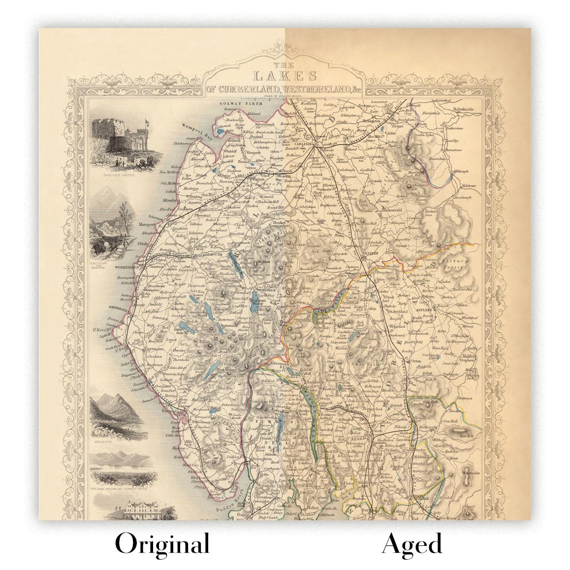
Vieillissement de la carte
Au fil des ans, des clients m'ont demandé des centaines de fois s'ils pouvaient acheter une carte qui semble uniforme. plus vieux.
Eh bien, vous pouvez désormais le faire en sélectionnant Aged avant d'ajouter une carte à votre panier.
Toutes les photos de produits que vous voyez sur cette page montrent la carte dans sa forme originale. Voilà à quoi ressemble la carte aujourd'hui.
Si vous sélectionnez Vieilli, je vieillirai votre carte à la main, en utilisant un processus spécial et unique développé au cours d'années d'étude de cartes anciennes, de discussions avec des chercheurs pour comprendre la chimie du vieillissement du papier, et bien sûr... beaucoup de pratique !
Si vous n'êtes pas sûr, respectez la couleur originale de la carte. Si vous voulez quelque chose d'un peu plus sombre et plus vieux à la recherche, optez pour Aged.
Si vous n'êtes pas satisfait de votre commande pour une raison quelconque, contactez-moi pour un remboursement sans conditions. Veuillez consulter notre politique de retours et de remboursements pour plus d'informations.
Je suis très confiant que vous aimerez votre carte restaurée ou votre impression artistique. Je fais cela depuis 1984. Je suis un vendeur Etsy 5 étoiles. J'ai vendu des dizaines de milliers de cartes et d'impressions artistiques et j'ai plus de 5 000 vrais avis 5 étoiles.
J'utilise un processus unique pour restaurer des cartes et des œuvres d'art qui est extrêmement chronophage et exigeant en main-d'œuvre. Trouver les cartes et illustrations originales peut prendre des mois. J'utilise une technologie de pointe et incroyablement coûteuse pour les numériser et les restaurer. En conséquence, je garantis que mes cartes et impressions artistiques sont d'une qualité supérieure - c'est pourquoi je peux offrir un remboursement sans conditions.
Presque toutes mes cartes et impressions artistiques ont l'air incroyables en grandes tailles (200 cm, 6,5 pieds+) et je peux également les encadrer et vous les livrer, via un transporteur spécial surdimensionné. Contactez-moi pour discuter de vos besoins spécifiques.
Or try searching for something!


