

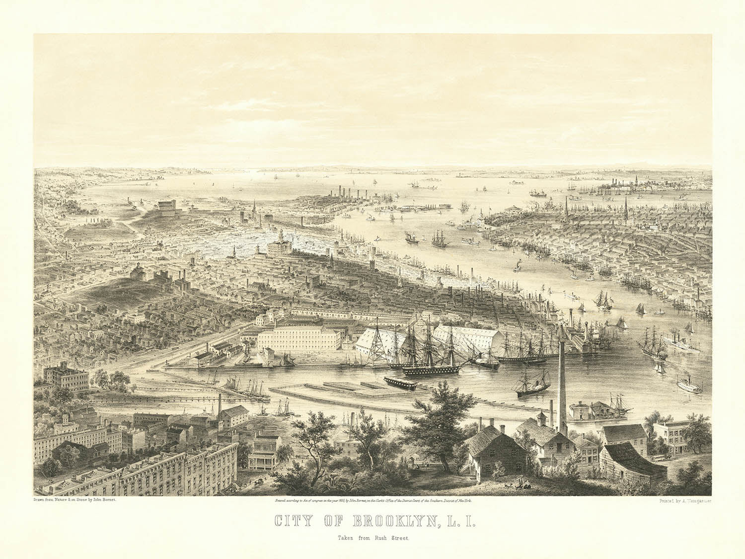


Ancienne carte Bird's-Eye de Brooklyn par Bornet, 1855: Arsenal naval, Brooklyn Heights, DUMBO, Williamsburg, Lower Manhattan
20% de réduction sur 2 — 33% de réduction sur 3
Ajoutez n'importe quel deux articles éligibles à votre panier pour recevoir 20% de réduction. Ajoutez un troisième et il sera offert (équivalent à 33% de réduction lors de l'achat de trois).
Aucun code nécessaire — l'offre s'applique automatiquement au moment du paiement.
Valide sur toutes les cartes standard et les impressions d'art. Vous pouvez mélanger et assortir n'importe quel design.
Si vous souhaitez expédier des articles à plusieurs adresses, veuillez nous contacter avant de passer votre commande.
Les commandes personnalisées et sur mesure sont exclues.
Contactez-nous si vous avez des questions
 Conçu à Londres Fabriqué en the USA
Conçu à Londres • Fabriqué en the USA
Conçu à Londres Fabriqué en the USA
Conçu à Londres • Fabriqué en the USA

Choose your size
Choose your finish


(Plus d’infos)
Message cadeau & finition personnalisée

Si vous souhaitez ajouter un message cadeau, ou une finition (puzzle, panneau en aluminium, etc.) qui n'est pas disponible ici, veuillez le demander dans la "note de commande" lors de votre passage à la caisse.
Chaque commande est fabriquée sur mesure, donc si vous avez besoin d'ajuster légèrement la taille, ou d'imprimer sur un matériau inhabituel, faites-le nous savoir. Nous avons réalisé des milliers de commandes personnalisées au fil des ans, donc il n'y a (presque) rien que nous ne puissions gérer.
Vous pouvez également nous contacter avant de passer votre commande, si vous le souhaitez !

- Made locally for fast, safe delivery
- No import duty or hidden fees
- Need advice? Message us on WhatsApp
Own a piece of history
7,000+ 5 star reviews


Entrez dans le monde dynamique de New York au milieu du 19ème siècle avec « City of Brooklyn, L.I. Taken from Rush Street, » une vue rare et évocatrice prise d'un oiseau, réalisée par l'artiste et lithographe accompli John Bornet en 1855. Cette carte remarquable capture Brooklyn à un moment transformateur, à la croisée de ses racines pastorales et de son avenir industriel en plein essor. Le point de vue depuis Williamsburg s'étend au sud-est à travers le Brooklyn Naval Yard, offrant un tableau panoramique qui englobe non seulement les quartiers de Brooklyn Heights et DUMBO mais aussi la silhouette emblématique de Lower Manhattan scintillant au-dessus de l'East River.
Ce qui rend cette carte de la ville particulièrement captivante est son mélange harmonieux de tranquillité semi-rurale et d'ambition urbaine. Au premier plan, on trouve des scènes évocatrices de fermes et de terres ouvertes — vestiges du passé agricole de Brooklyn — tandis qu'à peine plus loin, le pouls de la ville s'accélère avec des grappes d'entrepôts denses, des quais animés et la présence imposante du Brooklyn Naval Yard. Ici, de grands navires de guerre ancrent la scène, soulignant l'importance stratégique et économique de la région durant une période de croissance nationale et de puissance maritime.
L'art de Bornet est évident dans chaque détail, de la représentation méticuleuse des bâtiments individuels à la représentation vivante des navires et du commerce le long de l'East River. La perspective de la carte offre non seulement une vue complète des quartiers de Brooklyn — tels que l'élégant Brooklyn Heights et le front de mer industriel de DUMBO — mais met également en lumière le réseau complexe de rues qui allait bientôt définir le tissu urbain de l'arrondissement. Des artères notables comme Fulton Street, Myrtle Avenue et Washington Street sont clairement étiquetées, fournissant un aperçu fascinant de la géographie évolutive de la ville.
Cette carte est un témoignage de la transformation rapide de Brooklyn durant les années 1850, une décennie où la ville s'étendait tant en population qu'en puissance économique. La présence de monuments significatifs, tels que le Brooklyn Naval Yard, aux côtés du trafic fluvial animé, illustre l'identité duale de la ville en tant que centre industriel et porte d'entrée vers le monde extérieur. L'inclusion soigneuse de Lower Manhattan au loin sert de rappel poignant des liens étroits entre ces deux géants urbains, même avant la construction du Brooklyn Bridge.
John Bornet, l'artiste derrière cette vue, était renommé pour sa capacité à capturer l'esprit des paysages urbains de New York. Son double rôle d'artiste et de lithographe a assuré que chaque élément de la carte — de l'ombrage délicat des périphéries semi-rurales à la précision architecturale des blocs urbains — était rendu avec une clarté exceptionnelle et une fidélité historique. Aujourd'hui, cette carte est célébrée non seulement pour sa rareté mais aussi pour sa représentation vivante d'une ville sur le seuil de la modernité, en faisant un ajout prisé pour les collectionneurs et les passionnés d'histoire.
Rues et routes sur cette carte
- Adams St.
- Atlantic St.
- Bridge St.
- Clinton Ave.
- Clinton St.
- Concord St.
- Court St.
- Cumberland St.
- DeKalb Ave.
- Duffield St.
- Flushing Ave.
- Franklin Ave.
- Fulton Ave.
- Fulton St.
- Gold St.
- Hicks St.
- Hudson Ave.
- Jay St.
- Lafayette Ave.
- Main St.
- Myrtle Ave.
- Nassau St.
- Navy St.
- Pacific St.
- Pearl St.
- Portland Ave.
- Rush St.
- Sands St.
- Tillary St.
- Washington St.
Caractéristiques et monuments notables
- Chantier naval de Brooklyn (clairement représenté avec de grands navires de guerre)
- Silhouette de Lower Manhattan (visible en arrière-plan)
- De nombreux voiliers et bateaux à vapeur dans l'East River
- Brooklyn Heights
- Williamsburg
- DUMBO (zone près du front de mer)
- Ferme semi-rurale et bâtiments agricoles au premier plan
- Bâtiments industriels et entrepôts près du front de mer
- Représentation détaillée des navires et de l'activité maritime dans l'East River
Contexte historique et de design
- Nom de la carte : Ville de Brooklyn, L.I. Prise depuis Rush Street
- Date de création : 1855
- Cartographe et éditeur : John Bornet, un habile créateur de vues de New York qui était à la fois l'artiste original et le lithographe de cette carte
- Perspective et point de vue : Vue aérienne de Williamsburg, regardant au sud-est sur le chantier naval de Brooklyn vers Brooklyn Heights, DUMBO et Lower Manhattan
- Couverture géographique : Représente principalement Brooklyn (y compris Brooklyn Heights, DUMBO, Williamsburg et le chantier naval de Brooklyn) et Lower Manhattan, New York, États-Unis
- Style et design : Vue picturale lithographiée en deux pierres, un style populaire au milieu du 19ème siècle, mettant en avant des illustrations détaillées de bâtiments, de navires et de paysages urbains
- Thèmes et sujets : Développement urbain, industrialisation, commerce, activité maritime et vie semi-rurale à Brooklyn au milieu du 19ème siècle
- Importance historique : Fournit un rare enregistrement visuel de Brooklyn et de Lower Manhattan pendant une période de croissance rapide et de transition des paysages ruraux aux paysages urbains industriels. La présence de grands navires de guerre souligne l'importance stratégique et économique du chantier naval de Brooklyn à l'époque
- Rareté : Cette carte est considérée comme très rare, avec des exemples connus conservés par des institutions prestigieuses telles que la Bibliothèque publique de New York, le Musée de la ville de New York et la Galerie d'art de Yale
Veuillez vérifier les images pour vous assurer qu'une ville ou un lieu spécifique est représenté sur cette carte. Vous pouvez également nous contacter et nous demander de vérifier la carte pour vous.
Cette carte a fière allure à toutes les tailles, mais je recommande toujours d'opter pour une taille plus grande si vous avez de l'espace. De cette façon, vous pouvez facilement distinguer tous les détails.
Cette carte est incroyable à des tailles allant jusqu'à 100 pouces (250 cm). Si vous recherchez une carte plus grande, veuillez nous contacter.
Le modèle dans les images de l'annonce tient la version 18x24 pouces (45x60 cm) de cette carte.
La cinquième image de l'annonce montre un exemple de mon service de personnalisation de carte.
Si vous recherchez quelque chose de légèrement différent, consultez ma collection des meilleures anciennes cartes pour voir si quelque chose d'autre attire votre attention.
Veuillez me contacter pour vérifier si un certain emplacement, monument ou caractéristique est représenté sur cette carte.
Cela ferait un merveilleux cadeau d'anniversaire, de Noël, pour la fête des pères, un départ au travail, un anniversaire de mariage ou une pendaison de crémaillère pour quelqu'un des régions couvertes par cette carte.
Cette carte est disponible en tant qu'impression giclée sur papier mat d'archive sans acide, ou vous pouvez l'acheter encadrée. Le cadre est un joli cadre noir simple qui convient à la plupart des esthétiques. Veuillez me contacter si vous souhaitez une couleur ou un matériau de cadre différent. Mes cadres sont vitrées avec un acrylique de musée super clair (perspex/acrylite), qui est beaucoup moins réfléchissant que le verre, plus sûr, et arrivera toujours en parfait état.
This map is also available as a float framed canvas, sometimes known as a shadow gap framed canvas or canvas floater. The map is printed on artist's cotton canvas and then stretched over a handmade box frame. We then "float" the canvas inside a wooden frame, which is available in a range of colours (black, dark brown, oak, antique gold and white). This is a wonderful way to present a map without glazing in front. See some examples of float framed canvas maps and explore the differences between my different finishes.
For something truly unique, this map is also available in "Unique 3D", our trademarked process that dramatically transforms the map so that it has a wonderful sense of depth. We combine the original map with detailed topography and elevation data, so that mountains and the terrain really "pop". For more info and examples of 3D maps, check my Unique 3D page.
Many of our maps and art prints are chosen as thoughtful gifts for homes, offices, studies and meaningful places.
Choose a framed option for the easiest ready-to-hang gift, or choose an unframed print if the recipient may prefer to select their own frame.
We make orders locally in 23 countries around the world, so gifts can often be produced close to the recipient. This helps them arrive faster, travel more safely, and avoid customs or import duty surprises.
- We can deliver directly to the recipient
- Framed pieces arrive ready to hang
- Unframed prints are carefully packed in a strong protective tube
- Almost every order is made locally, for faster, safer gifting
- 90-day returns give the recipient time to decide
If you are not sure what to choose, please contact us. We can help you pick the right map, size, finish or delivery option.
Pour la plupart des commandes, le délai de livraison est d'environ 3 jours ouvrables. Les produits personnalisés et sur mesure prennent plus de temps, car je dois faire la personnalisation et vous l'envoyer pour approbation, ce qui prend généralement 1 ou 2 jours.
Veuillez noter que les grandes commandes encadrées prennent généralement plus de temps à réaliser et à livrer.
Si vous avez besoin que votre commande arrive à une date précise, veuillez me contacter avant de passer votre commande afin que nous puissions trouver le meilleur moyen de nous assurer que vous receviez votre commande à temps.
J'imprime et encadre des cartes et des œuvres d'art dans 23 pays à travers le monde. Cela signifie que votre commande sera réalisée localement, ce qui réduit le temps de livraison et garantit qu'elle ne sera pas endommagée pendant le transport. Vous ne paierez jamais de droits de douane ou d'importation, et nous mettrons moins de CO2 dans l'air.
Toutes mes cartes et impressions artistiques sont bien emballées et envoyées dans un tube robuste si non encadrées, ou entourées de mousse si encadrées.
J'essaie d'envoyer toutes les commandes dans les 1 ou 2 jours suivant la réception de votre commande, bien que certains produits (comme les masques, les mugs et les sacs fourre-tout) puissent prendre plus de temps à réaliser.
Si vous choisissez Livraison Express lors du paiement, nous donnerons la priorité à votre commande et l'enverrons par un service de messagerie de 1 jour (Fedex, DHL, UPS, Parcelforce).
La livraison le lendemain est également disponible dans certains pays (États-Unis, Royaume-Uni, Singapour, Émirats Arabes Unis), mais veuillez essayer de commander tôt dans la journée afin que nous puissions l'envoyer à temps.
Lisez mon guide complet sur la livraison et la production locale
Mon cadre standard est un cadre en bois dur noir de style galerie. Il est simple et a un aspect assez moderne. Mon cadre standard mesure environ 20 mm (0,8 po) de large.
J'utilise de l'acrylique super clair (perspex/acrylite) pour le verre du cadre. C'est plus léger et plus sûr que le verre - et cela a meilleur aspect, car la réflexivité est plus faible.
Six couleurs de cadre standard sont disponibles gratuitement (noir, marron foncé, gris foncé, chêne, blanc et or antique). Des encadrements et montages/matelassages personnalisés sont disponibles si vous recherchez autre chose.
La plupart des cartes, œuvres d'art et illustrations sont également disponibles sous forme de toile encadrée. Nous utilisons une toile en coton mate (non brillante), que nous tendons sur un cadre en bois de boîte provenant de sources durables, puis nous 'flottions' la pièce à l'intérieur d'un cadre en bois. Le résultat final est assez beau, et il n'y a pas de vitrage qui gêne.
Tous les cadres sont fournis "prêts à accrocher", avec soit une corde, soit des supports à l'arrière. Les très grands cadres auront des plaques de suspension lourdes et/ou une latte de montage. Si vous avez des questions, veuillez nous contacter.
Voir quelques exemples de mes cartes encadrées et de cartes en toile encadrées.
Alternativement, je peux également fournir de vieilles cartes et œuvres d'art sur toile, sur panneau en mousse, en coton et d'autres matériaux.
Si vous souhaitez encadrer votre carte ou œuvre d'art vous-même, veuillez lire d'abord mon guide des tailles.
Mes cartes sont des reproductions de cartes originales de très haute qualité.
Je recherche des cartes originales et rares auprès de bibliothèques, de maisons de ventes aux enchères et de collections privées du monde entier, je les restaure dans mon atelier de Londres, puis j'utilise des encres et des imprimantes giclées spécialisées pour créer de magnifiques cartes encore plus belles que l'originale.
Mes cartes sont imprimées sur du papier d’archives mat (non brillant) sans acide qui semble de très haute qualité et ressemble presque à une carte. En termes techniques, le grammage/épaisseur du papier est de 10 mil/200 g/m². C'est parfait pour l'encadrement.
J’imprime avec des encres pigmentaires Epson ultrachrome giclée UV résistantes à la décoloration – certaines des meilleures encres que vous puissiez trouver.
je peux aussi faire cartes sur toile, chiffon en coton et autres matériaux exotiques.
En savoir plus sur Unique Maps Co..
Personnalisation de la carte
Si vous recherchez le cadeau parfait pour un anniversaire ou une pendaison de crémaillère, je peux personnaliser votre carte pour la rendre vraiment unique. Par exemple, je peux ajouter un court message, mettre en évidence un lieu important ou ajouter les armoiries de votre famille.
Les options sont presque infinies. S'il vous plaît voir mon page de personnalisation de la carte pour quelques merveilleux exemples de ce qui est possible.
Pour commander une carte personnalisée, sélectionnez « personnaliser votre carte » avant de l'ajouter à votre panier.
Entrer en contact si vous recherchez des personnalisations et des personnalisations plus complexes.
Vieillissement de la carte
Au fil des ans, des clients m'ont demandé des centaines de fois s'ils pouvaient acheter une carte qui semble uniforme. plus vieux.
Eh bien, vous pouvez désormais le faire en sélectionnant Aged avant d'ajouter une carte à votre panier.
Toutes les photos de produits que vous voyez sur cette page montrent la carte dans sa forme originale. Voilà à quoi ressemble la carte aujourd'hui.
Si vous sélectionnez Vieilli, je vieillirai votre carte à la main, en utilisant un processus spécial et unique développé au cours d'années d'étude de cartes anciennes, de discussions avec des chercheurs pour comprendre la chimie du vieillissement du papier, et bien sûr... beaucoup de pratique !
Si vous n'êtes pas sûr, respectez la couleur originale de la carte. Si vous voulez quelque chose d'un peu plus sombre et plus vieux à la recherche, optez pour Aged.
Si vous n'êtes pas satisfait de votre commande pour une raison quelconque, contactez-moi pour un remboursement sans conditions. Veuillez consulter notre politique de retours et de remboursements pour plus d'informations.
Je suis très confiant que vous aimerez votre carte restaurée ou votre impression artistique. Je fais cela depuis 1984. Je suis un vendeur Etsy 5 étoiles. J'ai vendu des dizaines de milliers de cartes et d'impressions artistiques et j'ai plus de 5 000 vrais avis 5 étoiles.
J'utilise un processus unique pour restaurer des cartes et des œuvres d'art qui est extrêmement chronophage et exigeant en main-d'œuvre. Trouver les cartes et illustrations originales peut prendre des mois. J'utilise une technologie de pointe et incroyablement coûteuse pour les numériser et les restaurer. En conséquence, je garantis que mes cartes et impressions artistiques sont d'une qualité supérieure - c'est pourquoi je peux offrir un remboursement sans conditions.
Presque toutes mes cartes et impressions artistiques ont l'air incroyables en grandes tailles (200 cm, 6,5 pieds+) et je peux également les encadrer et vous les livrer, via un transporteur spécial surdimensionné. Contactez-moi pour discuter de vos besoins spécifiques.
Or try searching for something!


