

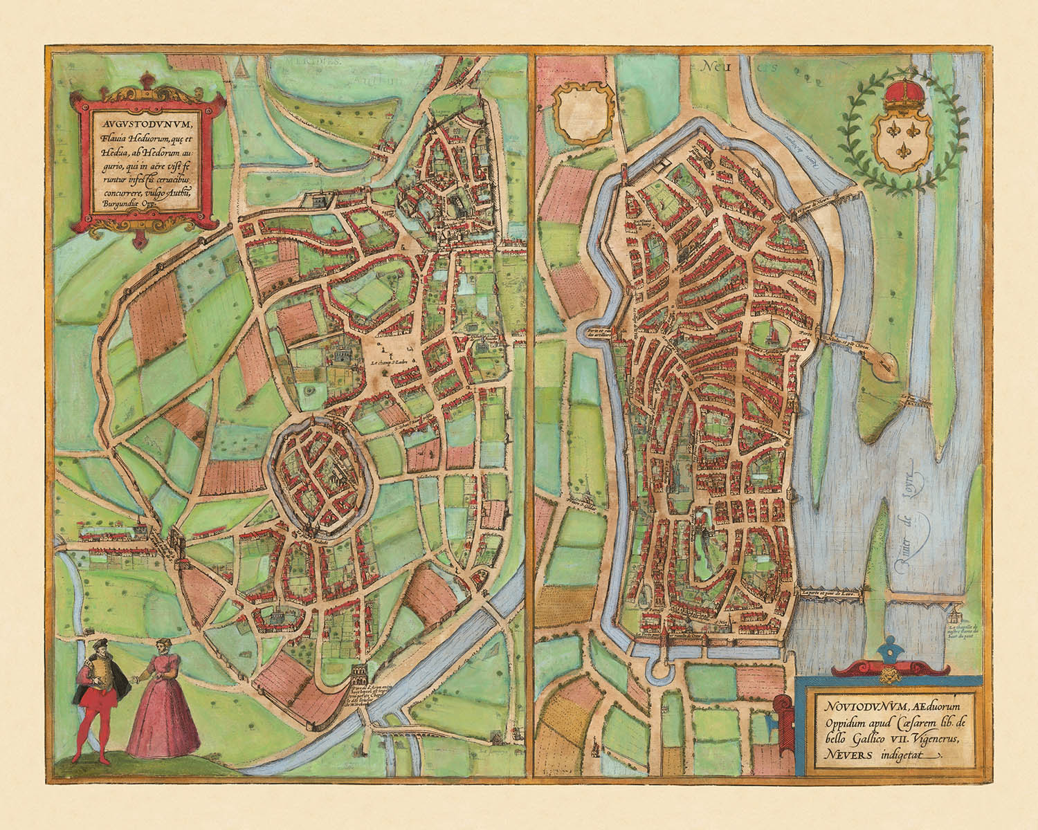


Ancienne carte d'Autun et de Nevers par Braun et Hogenberg, 1581: murs de la ville, cathédrales, palais ducal, rivières Loire et Arroux, ponts
Livraison pour la fête des Pères
La période de livraison gratuite pour la fête des Pères touche presque à sa fin. Les commandes passées aujourd’hui avec livraison gratuite peuvent encore arriver à temps.
La livraison express est disponible au moment du paiement pour une livraison en 1 à 2 jours, et la livraison le lendemain est disponible dans certains pays pour les commandes passées avant 10 h.
Les commandes personnalisées peuvent prendre un peu plus de temps, car nous préparons une épreuve de design pour votre approbation avant la fabrication et l’expédition de votre commande.
Après votre commande, vous pouvez envoyer un magnifique aperçu cadeau numérique au destinataire. C’est idéal si vous craignez que la commande n’arrive pas à temps pour la fête des Pères.
Veuillez commander dès que possible afin de maximiser vos chances de livraison à temps pour la fête des Pères.
Contactez-nous si vous souhaitez de l’aide pour choisir l’option la plus rapide.
 Conçu à Londres Fabriqué en the USA
Conçu à Londres • Fabriqué en the USA
Conçu à Londres Fabriqué en the USA
Conçu à Londres • Fabriqué en the USA

Choose your size
Choose your finish


(Plus d’infos)
Message cadeau & finition personnalisée

Si vous souhaitez ajouter un message cadeau, ou une finition (puzzle, panneau en aluminium, etc.) qui n'est pas disponible ici, veuillez le demander dans la "note de commande" lors de votre passage à la caisse.
Chaque commande est fabriquée sur mesure, donc si vous avez besoin d'ajuster légèrement la taille, ou d'imprimer sur un matériau inhabituel, faites-le nous savoir. Nous avons réalisé des milliers de commandes personnalisées au fil des ans, donc il n'y a (presque) rien que nous ne puissions gérer.
Vous pouvez également nous contacter avant de passer votre commande, si vous le souhaitez !

- Made locally for fast, safe delivery
- No import duty or hidden fees
- Need advice? Message us on WhatsApp
Own a piece of history
7,000+ 5 star reviews


Entrez dans le monde de la France de la fin de la Renaissance avec cette carte de ville exquise, intitulée "[Autun et Nevers] Augustodunum, Flavia Heduorum, que et Hedua, ab Hedorum augurio . . . / Noviodunum, Aeduorum Oppidum apud Casearem lib. de bello Gallico VII Vigenerus, Nevers indigetat." Réalisée en 1581 par le duo célèbre Georg Braun et Frans Hogenberg, cette carte est une fenêtre rare et éclairante sur le cœur urbain de la Bourgogne. Le titre latin original, imprégné de références classiques et gauloises, signale immédiatement la profondeur historique et l'importance des villes représentées—Autun (Augustodunum) et Nevers (Noviodunum)—toutes deux ayant joué des rôles importants dans l'histoire romaine et médiévale française.
Ce qui distingue cette carte, c'est sa perspective à vol d'oiseau à couper le souffle, une caractéristique de l'art de Braun & Hogenberg. Les villes fortifiées d'Autun et de Nevers sont rendues avec une attention méticuleuse à leurs fortifications, révélant les priorités défensives de l'époque. La carte capture la géométrie complexe des murs de la ville, des bastions et des portes, tous nichés dans une campagne verdoyante. Les rivières serpentent à travers le paysage—l'Arroux près d'Autun et la majestueuse Loire près de Nevers—connectant la vie urbaine animée aux champs fertiles au-delà.
À l'intérieur des murs de la ville, des monuments significatifs se détachent. À Autun, la grande cathédrale Saint-Lazare domine le ciel, ses tours romanes un témoignage de l'héritage ecclésiastique de la ville. Nevers, aussi, possède sa cathédrale imposante et le palais ducal fortifié, chaque structure étant soigneusement illustrée pour transmettre leur gravité architecturale. Des cartouches décoratifs et des blasons héraldiques embellissent la composition, soulignant la fierté civique et la lignée noble de ces centres historiques.
Cette carte n'est pas simplement un enregistrement des rues et des bâtiments ; c'est une célébration de l'identité urbaine et de l'accomplissement cartographique de la Renaissance. Des personnages en costume d'époque animent le premier plan, offrant un aperçu de la vie quotidienne et du tissu social du 16ème siècle. La campagne environnante, parsemée de maisons rurales et de champs ouverts, fournit un contraste dramatique avec les cœurs urbains denses, mettant en lumière l'interaction entre la ville et l'arrière-pays qui a façonné la prospérité de la région.
La signification historique de cette carte est amplifiée par son inclusion dans le légendaire Civitates Orbis Terrarum, l'atlas en six volumes qui a établi la norme pour la cartographie des villes dans l'Europe moderne précoce. La collaboration de Braun & Hogenberg a produit certaines des vues de ville les plus influentes de leur temps, et cette carte d'Autun et de Nevers se dresse comme un témoignage de leur vision. C'est un acquisition essentielle pour les collectionneurs et les connaisseurs qui apprécient la fusion de l'art, de l'histoire et de la géographie urbaine à l'aube de l'âge moderne.
Caractéristiques et Monuments Notables
- Deux vues principales de la ville : Autun (Augustodunum) et Nevers (Noviodunum), chacune représentée en détail.
- Murs de la ville et fortifications entourant Autun et Nevers.
- Rivières traversant ou près des deux villes (la rivière Arroux pour Autun et la rivière Loire pour Nevers).
- Cathédrales ou églises proéminentes visibles dans les deux villes (notamment la cathédrale Saint-Lazare à Autun et la cathédrale de Nevers).
- Châteaux ou structures fortifiées à l'intérieur ou adjacent aux murs de la ville.
- Des ponts traversant les rivières près des villes.
- Campagne ouverte, champs et bâtiments ruraux entourant les centres urbains.
- Cartouches décoratifs avec des titres latins et des textes descriptifs.
- Des figures en costume d'époque représentées au premier plan pour un effet décoratif et contextuel.
- Des boucliers héraldiques ou des armoiries associés aux villes.
Contexte historique et de design
- Nom de la carte : [Autun et Nevers] Augustodunum, Flavia Heduorum, que et Hedua, ab Hedorum augurio . . . / Noviodunum, Aeduorum Oppidum apud Casearem lib. de bello Gallico VII Vigenerus, Nevers indigetat.
- Ceci est un exemple notable des premiers plans de ville d'Autun et Nevers, présenté dans l'œuvre monumentale en 6 volumes de Braun & Hogenberg, Civitates Orbis Terrarum, qui était l'un des premiers atlas complets de vues et de cartes de villes.
- Date de création : 1581.
- Cartographes/éditeurs : Georg Braun & Frans Hogenberg, renommés pour leur collaboration sur le Civitates Orbis Terrarum (publié de 1572 à 1617), un atlas marquant qui représentait des villes à travers l'Europe et au-delà.
- La carte présente des représentations picturales en vue aérienne des villes d'Autun et Nevers (dans la France actuelle), se concentrant sur l'aménagement urbain, les fortifications et les bâtiments significatifs.
- La carte est une vue aérienne de la ville, typique de la cartographie européenne de la fin du 16ème siècle, avec des illustrations détaillées de bâtiments, de fortifications, de rivières et de la campagne environnante.
- La carte offre un aperçu précieux de la forme urbaine, de l'architecture et des structures défensives des villes françaises à la fin de la Renaissance. Elle est également significative en tant que partie du Civitates Orbis Terrarum, qui a contribué à façonner les perceptions européennes des villes et de la géographie urbaine pendant cette période.
Veuillez vérifier les images pour vous assurer qu'une ville ou un lieu spécifique est représenté sur cette carte. Vous pouvez également nous contacter et nous demander de vérifier la carte pour vous.
Cette carte a fière allure à toutes les tailles, mais je recommande toujours d'opter pour une taille plus grande si vous avez de l'espace. Ainsi, vous pourrez facilement distinguer tous les détails.
Cette carte est incroyable à des tailles allant jusqu'à 70in (180cm). Si vous recherchez une carte plus grande, veuillez nous contacter.
Le modèle sur les images de la liste tient la version 16x20in (40x50cm) de cette carte.
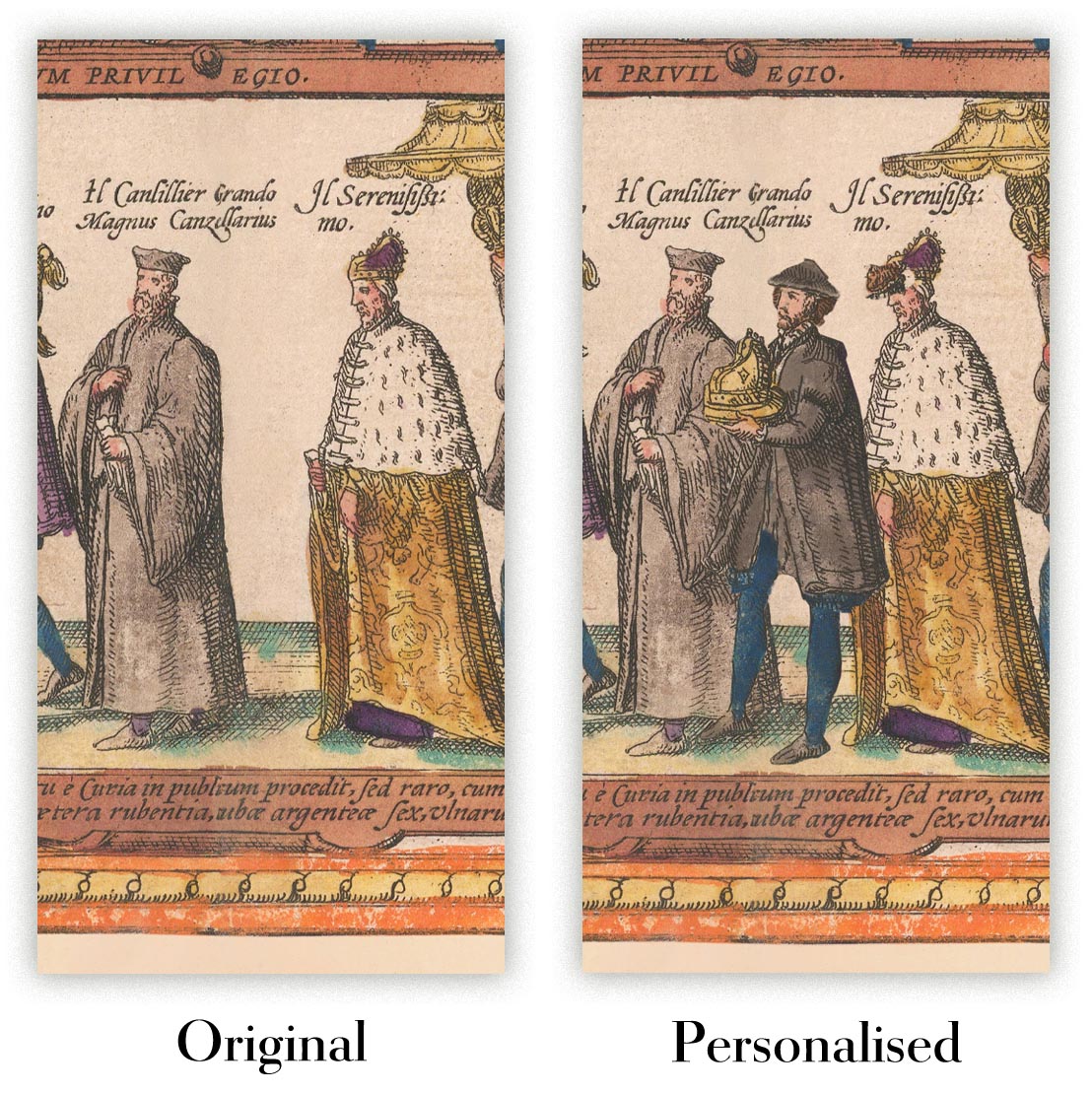
La cinquième image de la liste montre un exemple de mon service de personnalisation de carte.
Si vous recherchez quelque chose de légèrement différent, consultez ma collection des meilleures anciennes cartes pour voir si quelque chose d'autre attire votre attention.
Veuillez me contacter pour vérifier si un certain emplacement, monument ou caractéristique est représenté sur cette carte.
Ceci ferait un merveilleux cadeau d'anniversaire, de Noël, pour la fête des pères, pour un départ au travail, un anniversaire de mariage ou une pendaison de crémaillère pour quelqu'un des zones couvertes par cette carte.
Cette carte est disponible en tant qu'impression giclée sur papier mat d'archive sans acide, ou vous pouvez l'acheter encadrée. Le cadre est un joli cadre noir simple qui convient à la plupart des esthétiques. Veuillez nous contacter si vous souhaitez une couleur ou un matériau de cadre différent. Mes cadres sont vitrées avec de l'acrylique super clair de qualité musée (perspex/acrylite), qui est significativement moins réfléchissant que le verre, plus sûr, et arrivera toujours en parfait état.
This map is also available as a float framed canvas, sometimes known as a shadow gap framed canvas or canvas floater. The map is printed on artist's cotton canvas and then stretched over a handmade box frame. We then "float" the canvas inside a wooden frame, which is available in a range of colours (black, dark brown, oak, antique gold and white). This is a wonderful way to present a map without glazing in front. See some examples of float framed canvas maps and explore the differences between my different finishes.
For something truly unique, this map is also available in "Unique 3D", our trademarked process that dramatically transforms the map so that it has a wonderful sense of depth. We combine the original map with detailed topography and elevation data, so that mountains and the terrain really "pop". For more info and examples of 3D maps, check my Unique 3D page.
Many of our maps and art prints are chosen as thoughtful gifts for homes, offices, studies and meaningful places.
Choose a framed option for the easiest ready-to-hang gift, or choose an unframed print if the recipient may prefer to select their own frame.
We make orders locally in 23 countries around the world, so gifts can often be produced close to the recipient. This helps them arrive faster, travel more safely, and avoid customs or import duty surprises.
- We can deliver directly to the recipient
- Framed pieces arrive ready to hang
- Unframed prints are carefully packed in a strong protective tube
- Almost every order is made locally, for faster, safer gifting
- 90-day returns give the recipient time to decide
If you are not sure what to choose, please contact us. We can help you pick the right map, size, finish or delivery option.
Pour la plupart des commandes, le délai de livraison est d'environ 3 jours ouvrables. Les produits personnalisés et sur mesure prennent plus de temps, car je dois faire la personnalisation et vous l'envoyer pour approbation, ce qui prend généralement 1 ou 2 jours.
Veuillez noter que les grandes commandes encadrées prennent généralement plus de temps à réaliser et à livrer.
Si vous avez besoin que votre commande arrive à une date précise, veuillez me contacter avant de passer votre commande afin que nous puissions trouver le meilleur moyen de nous assurer que vous receviez votre commande à temps.
J'imprime et encadre des cartes et des œuvres d'art dans 23 pays à travers le monde. Cela signifie que votre commande sera réalisée localement, ce qui réduit le temps de livraison et garantit qu'elle ne sera pas endommagée pendant le transport. Vous ne paierez jamais de droits de douane ou d'importation, et nous mettrons moins de CO2 dans l'air.
Toutes mes cartes et impressions artistiques sont bien emballées et envoyées dans un tube robuste si non encadrées, ou entourées de mousse si encadrées.
J'essaie d'envoyer toutes les commandes dans les 1 ou 2 jours suivant la réception de votre commande, bien que certains produits (comme les masques, les mugs et les sacs fourre-tout) puissent prendre plus de temps à réaliser.
Si vous choisissez Livraison Express lors du paiement, nous donnerons la priorité à votre commande et l'enverrons par un service de messagerie de 1 jour (Fedex, DHL, UPS, Parcelforce).
La livraison le lendemain est également disponible dans certains pays (États-Unis, Royaume-Uni, Singapour, Émirats Arabes Unis), mais veuillez essayer de commander tôt dans la journée afin que nous puissions l'envoyer à temps.
Lisez mon guide complet sur la livraison et la production locale
Mon cadre standard est un cadre en bois dur noir de style galerie. Il est simple et a un aspect assez moderne. Mon cadre standard mesure environ 20 mm (0,8 po) de large.
J'utilise de l'acrylique super clair (perspex/acrylite) pour le verre du cadre. C'est plus léger et plus sûr que le verre - et cela a meilleur aspect, car la réflexivité est plus faible.
Six couleurs de cadre standard sont disponibles gratuitement (noir, marron foncé, gris foncé, chêne, blanc et or antique). Des encadrements et montages/matelassages personnalisés sont disponibles si vous recherchez autre chose.
La plupart des cartes, œuvres d'art et illustrations sont également disponibles sous forme de toile encadrée. Nous utilisons une toile en coton mate (non brillante), que nous tendons sur un cadre en bois de boîte provenant de sources durables, puis nous 'flottions' la pièce à l'intérieur d'un cadre en bois. Le résultat final est assez beau, et il n'y a pas de vitrage qui gêne.
Tous les cadres sont fournis "prêts à accrocher", avec soit une corde, soit des supports à l'arrière. Les très grands cadres auront des plaques de suspension lourdes et/ou une latte de montage. Si vous avez des questions, veuillez nous contacter.
Voir quelques exemples de mes cartes encadrées et de cartes en toile encadrées.
Alternativement, je peux également fournir de vieilles cartes et œuvres d'art sur toile, sur panneau en mousse, en coton et d'autres matériaux.
Si vous souhaitez encadrer votre carte ou œuvre d'art vous-même, veuillez lire d'abord mon guide des tailles.
Mes cartes sont des reproductions de cartes originales de très haute qualité.
Je recherche des cartes originales et rares auprès de bibliothèques, de maisons de ventes aux enchères et de collections privées du monde entier, je les restaure dans mon atelier de Londres, puis j'utilise des encres et des imprimantes giclées spécialisées pour créer de magnifiques cartes encore plus belles que l'originale.
Mes cartes sont imprimées sur du papier d’archives mat (non brillant) sans acide qui semble de très haute qualité et ressemble presque à une carte. En termes techniques, le grammage/épaisseur du papier est de 10 mil/200 g/m². C'est parfait pour l'encadrement.
J’imprime avec des encres pigmentaires Epson ultrachrome giclée UV résistantes à la décoloration – certaines des meilleures encres que vous puissiez trouver.
je peux aussi faire cartes sur toile, chiffon en coton et autres matériaux exotiques.
En savoir plus sur Unique Maps Co..
Personnalisation de la carte
Si vous recherchez le cadeau parfait pour un anniversaire ou une pendaison de crémaillère, je peux personnaliser votre carte pour la rendre vraiment unique. Par exemple, je peux ajouter un court message, mettre en évidence un lieu important ou ajouter les armoiries de votre famille.
Les options sont presque infinies. S'il vous plaît voir mon page de personnalisation de la carte pour quelques merveilleux exemples de ce qui est possible.
Pour commander une carte personnalisée, sélectionnez « personnaliser votre carte » avant de l'ajouter à votre panier.
Entrer en contact si vous recherchez des personnalisations et des personnalisations plus complexes.
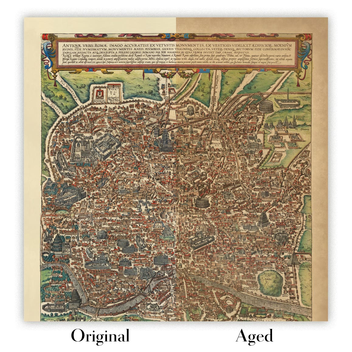
Vieillissement de la carte
Au fil des ans, des clients m'ont demandé des centaines de fois s'ils pouvaient acheter une carte qui semble uniforme. plus vieux.
Eh bien, vous pouvez désormais le faire en sélectionnant Aged avant d'ajouter une carte à votre panier.
Toutes les photos de produits que vous voyez sur cette page montrent la carte dans sa forme originale. Voilà à quoi ressemble la carte aujourd'hui.
Si vous sélectionnez Vieilli, je vieillirai votre carte à la main, en utilisant un processus spécial et unique développé au cours d'années d'étude de cartes anciennes, de discussions avec des chercheurs pour comprendre la chimie du vieillissement du papier, et bien sûr... beaucoup de pratique !
Si vous n'êtes pas sûr, respectez la couleur originale de la carte. Si vous voulez quelque chose d'un peu plus sombre et plus vieux à la recherche, optez pour Aged.
Si vous n'êtes pas satisfait de votre commande pour une raison quelconque, contactez-moi pour un remboursement sans conditions. Veuillez consulter notre politique de retours et de remboursements pour plus d'informations.
Je suis très confiant que vous aimerez votre carte restaurée ou votre impression artistique. Je fais cela depuis 1984. Je suis un vendeur Etsy 5 étoiles. J'ai vendu des dizaines de milliers de cartes et d'impressions artistiques et j'ai plus de 5 000 vrais avis 5 étoiles.
J'utilise un processus unique pour restaurer des cartes et des œuvres d'art qui est extrêmement chronophage et exigeant en main-d'œuvre. Trouver les cartes et illustrations originales peut prendre des mois. J'utilise une technologie de pointe et incroyablement coûteuse pour les numériser et les restaurer. En conséquence, je garantis que mes cartes et impressions artistiques sont d'une qualité supérieure - c'est pourquoi je peux offrir un remboursement sans conditions.
Presque toutes mes cartes et impressions artistiques ont l'air incroyables en grandes tailles (200 cm, 6,5 pieds+) et je peux également les encadrer et vous les livrer, via un transporteur spécial surdimensionné. Contactez-moi pour discuter de vos besoins spécifiques.
Or try searching for something!


