


L'Italie, botte de la Méditerranée, pourrait s'avérer le talon d'Achille de l'Axe, 1942: Carte de la stratégie alliée de la Seconde Guerre mondiale
20% de réduction sur 2 — 33% de réduction sur 3
Ajoutez n'importe quel deux articles éligibles à votre panier pour recevoir 20% de réduction. Ajoutez un troisième et il sera offert (équivalent à 33% de réduction lors de l'achat de trois).
Aucun code nécessaire — l'offre s'applique automatiquement au moment du paiement.
Valide sur toutes les cartes standard et les impressions d'art. Vous pouvez mélanger et assortir n'importe quel design.
Si vous souhaitez expédier des articles à plusieurs adresses, veuillez nous contacter avant de passer votre commande.
Les commandes personnalisées et sur mesure sont exclues.
Contactez-nous si vous avez des questions
 Conçu à Londres Fabriqué en the USA
Conçu à Londres • Fabriqué en the USA
Conçu à Londres Fabriqué en the USA
Conçu à Londres • Fabriqué en the USA

Restaurée à partir de la carte originale de 1942 et imprimée en qualité musée. Description complète ci-dessous.
Choose your size
Choose your finish


(Plus d’infos)
Message cadeau & finition personnalisée

Si vous souhaitez ajouter un message cadeau, ou une finition (puzzle, panneau en aluminium, etc.) qui n'est pas disponible ici, veuillez le demander dans la "note de commande" lors de votre passage à la caisse.
Chaque commande est fabriquée sur mesure, donc si vous avez besoin d'ajuster légèrement la taille, ou d'imprimer sur un matériau inhabituel, faites-le nous savoir. Nous avons réalisé des milliers de commandes personnalisées au fil des ans, donc il n'y a (presque) rien que nous ne puissions gérer.
Vous pouvez également nous contacter avant de passer votre commande, si vous le souhaitez !

Own a piece of history
7,000+ 5 star reviews


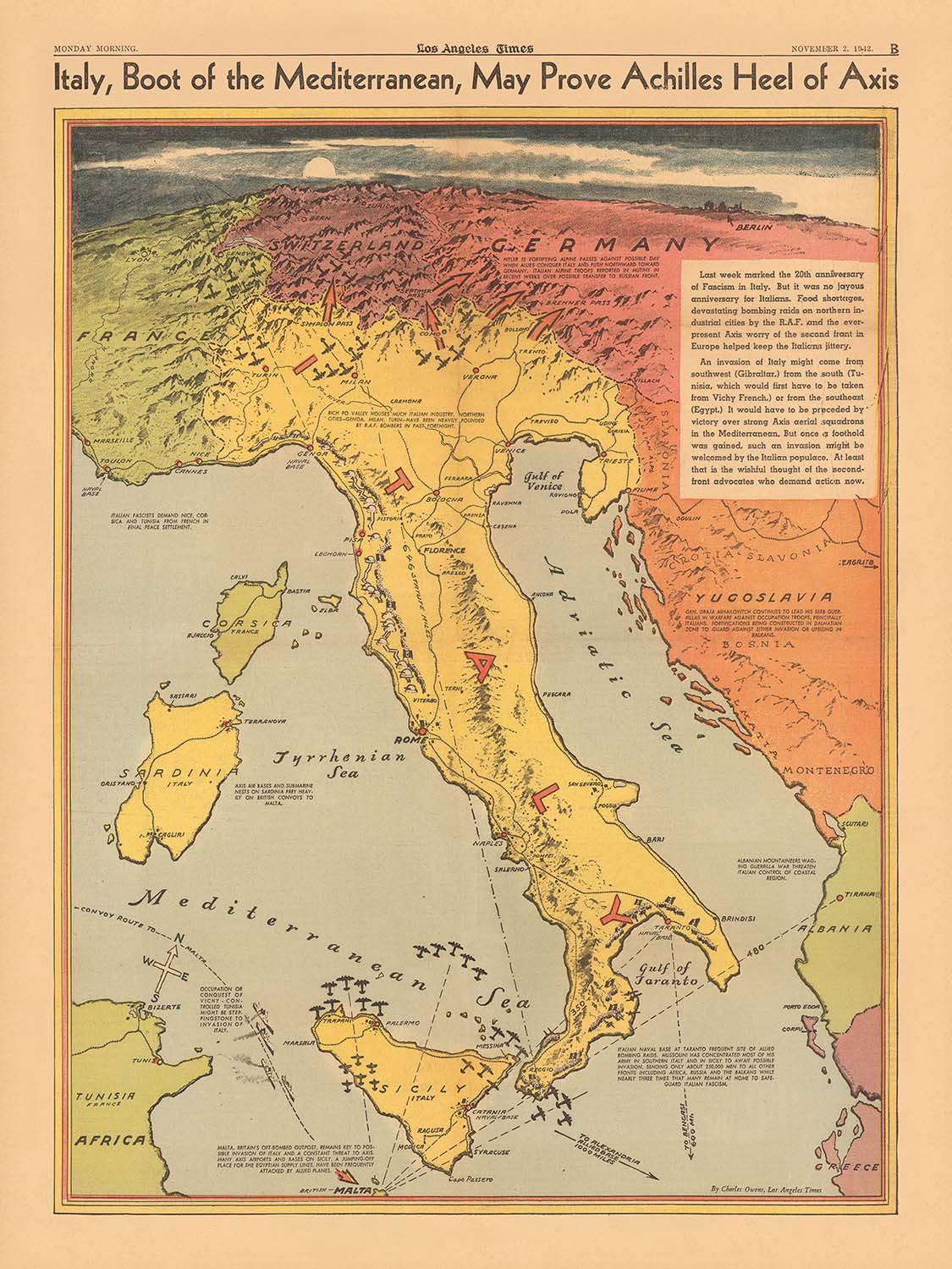
Entrez dans les moments clés de la Seconde Guerre mondiale avec cette remarquable carte de 1942, « L'Italie, botte de la Méditerranée, pourrait prouver le talon d'Achille de l'Axe », magistralement réalisée par Charles Owens pour le Los Angeles Times. Cette carte est plus qu'une simple représentation géographique—c'est un document vibrant et chargé d'histoire qui capture l'atmosphère tendue et les calculs stratégiques de l'époque. Conçue à un moment critique de la guerre, elle reflète les espoirs et les anxiétés des Alliés alors qu'ils considéraient la géographie unique de l'Italie comme une vulnérabilité potentielle dans les défenses des puissances de l'Axe.
Le focus thématique de la carte sur la stratégie militaire est immédiatement évident dans son illustration détaillée des routes de convois alliés et des lignes d'attaque aérienne rayonnant depuis la base britannique vitale à Malte. Ces routes se croisent dans la Méditerranée, convergeant vers des bastions clés de l'Axe et soulignant les lignes logistiques qui soutenaient l'effort de guerre. L'inclusion de distances annotées entre des lieux stratégiques, comme de Malte à la Sicile ou à l'Afrique du Nord, donne un sens tangible des défis opérationnels et des opportunités auxquels faisaient face les commandants alliés.
Le relief pictural et les couleurs vives donnent vie au terrain de l'Italie et de ses régions environnantes, mettant en avant la topographie dramatique qui a façonné les campagnes militaires. La « botte » de l'Italie, flanquée par les îles de Sicile, de Sardaigne et de Corse, est rendue avec à la fois un flair artistique et une précision cartographique. Des villes majeures comme Rome, Naples et Palerme sont clairement étiquetées, aux côtés de chemins de fer cruciaux, de ports et de bases militaires, soulignant l'importance des infrastructures dans la logistique et le mouvement en temps de guerre.
Cette carte est riche en notes historiques et en textes explicatifs, offrant des perspectives contemporaines sur le conflit en cours. Le titre lui-même, invoquant le mythe du talon d'Achille, cadre la position de l'Italie comme à la fois une force et une faiblesse potentiellement fatale pour l'Axe. Les éléments narratifs de la carte et la narration visuelle claire étaient conçus pour informer et rassembler le public américain, en faisant un exemple convaincant de journalisme de guerre et de propagande.
Historiquement, cette carte se dresse comme un témoignage des tournants stratégiques de 1942, lorsque les forces alliées prenaient de l'élan en Afrique du Nord et se préparaient à l'invasion éventuelle de l'Europe du Sud. Elle encapsule les anxiétés, les espoirs et les risques calculés de l'époque, offrant un aperçu de l'état d'esprit des planificateurs militaires et du grand public. En tant qu'œuvre d'art et d'histoire, cette carte offre aux collectionneurs et aux passionnés une opportunité unique de posséder un artefact tangible d'une des périodes les plus conséquentes du vingtième siècle.
Les lieux sur cette carte
- Rome
- Naples
- Palerme
- Gênes
- Milan
- Venise
- Florence
- Turin
- Bari
- Tarente
- Trieste
- Malte
- Cagliari (Sardaigne)
- Catania (Sicile)
- Messine (Sicile)
- Tripoli (Libye)
- Tobrouk (Libye)
- Tunis (Tunisie)
- Alger (Algérie)
- Alexandrie (Égypte)
Caractéristiques & Monuments Notables
- La forme de « botte » de l'Italie représentée de manière proéminente, soulignant sa position stratégique dans la Méditerranée
- Les routes de convois alliés à travers la mer Méditerranée, en particulier depuis Gibraltar et Alexandrie vers Malte et l'Afrique du Nord
- Lignes d'attaque aérienne provenant de Malte, montrant les opérations aériennes alliées ciblant les lignes d'approvisionnement et les positions de l'Axe
- Sicile et Sardaigne, avec des lieux stratégiques et des villes marquées
- La Corse, montrée au nord-ouest de l'Italie
- Côte nord-africaine, avec des lieux clés tels que Tripoli et Tobrouk
- Chemins de fer et lignes de transport en Italie, indiquant leur importance pour la logistique militaire
- Fortifications et bases militaires le long de la côte italienne et des îles
- Relief pictural (montagnes et collines), fournissant un aperçu du terrain
- Distances entre des points stratégiques (par exemple, de Malte à la Sicile ou à l'Afrique du Nord) annotées
- Notes textuelles expliquant l'importance de certaines routes ou emplacements
- Bases navales et aériennes alliées et de l'Axe marquées
- Le détroit de Messine, un passage étroit entre la Sicile et le continent italien, mis en évidence
- Les mers Tyrrhénienne, Adriatique et Ionienne étiquetées
- Flèches et symboles indiquant les directions de mouvement et d'attaques
- Insets ou notes latérales avec un contexte historique sur des batailles récentes ou des campagnes en cours
- Ports méditerranéens clés, tels que Gênes, Naples et Palerme, mis en évidence pour leur valeur stratégique
- Annotations sur la vulnérabilité des lignes d'approvisionnement italiennes
- Le canal de Suez et Gibraltar, montrés à la périphérie comme des points majeurs contrôlant l'accès à la Méditerranée
- La métaphore du "talon d'Achille" visuellement renforcée par la disposition et l'étiquetage de la carte
- Drapeaux ou insignes alliés et de l'Axe utilisés pour désigner le contrôle de zones spécifiques
- Date et informations sur l'éditeur affichées dans la légende ou la marge de la carte
- Textes explicatifs résumant les développements militaires récents
- Zones ombragées ou colorées pour désigner les régions sous contrôle de l'Axe ou des Alliés
- Sites de bataille importants, tels qu'El Alamein en Afrique du Nord, référencés ou montrés
- La légende de la carte expliquant les symboles et le codage couleur
Contexte historique et de conception
- Créé par Charles Owens et publié par le Los Angeles Times le 2 novembre 1942
- Conçu à un moment crucial de la Seconde Guerre mondiale, reflétant la pensée stratégique alliée alors qu'ils ciblaient les vulnérabilités géographiques de l'Italie
- Combine des informations militaires, géographiques et contextuelles dans un style thématique et pictural historiquement informatif
- Utilise des couleurs vives, des éléments picturaux et des étiquettes claires pour rendre les informations militaires complexes accessibles à un public général
- Inclut des explications textuelles et des notes historiques pour fournir un contexte aux lecteurs non-experts
- Réflète le style du journalisme de guerre et des graphiques d'information du début des années 1940
- Destiné à informer et à rassembler le public américain en mettant en lumière les stratégies alliées et les vulnérabilités de l'Axe
- Offre un aperçu des défis opérationnels et des opportunités auxquels étaient confrontés les commandants alliés pendant la campagne méditerranéenne
- Servir à la fois de ressource cartographique et de document historique informatif d'une des périodes les plus conséquentes du vingtième siècle
Veuillez vérifier les images pour vous assurer qu'une ville ou un endroit spécifique est montré sur cette carte. Vous pouvez également nous contacter et nous demander de vérifier la carte pour vous.
Cette carte a l'air géniale à toutes les tailles, mais je recommande toujours d'opter pour une taille plus grande si vous avez de l'espace. De cette manière, vous pouvez facilement distinguer tous les détails.
Cette carte a l'air incroyable à des tailles allant jusqu'à 70 pouces (180 cm). Si vous recherchez une carte plus grande, veuillez nous contacter.
Le modèle dans les images de la liste tient la version 18x24 pouces (45x60 cm) de cette carte.
La cinquième image de la liste montre un exemple de mon service de personnalisation de cartes.
Si vous cherchez quelque chose d'un peu différent, consultez ma collection des meilleures anciennes cartes pour voir si quelque chose d'autre attire votre attention.
Veuillez me contacter pour vérifier si un certain lieu, monument ou caractéristique est représenté sur cette carte.
Cela ferait un merveilleux cadeau d'anniversaire, de Noël, pour la fête des pères, pour un départ au travail, un anniversaire de mariage ou une pendaison de crémaillère pour quelqu'un des zones couvertes par cette carte.
Cette carte est disponible en tant qu'impression giclée sur papier mat d'archive sans acide, ou vous pouvez l'acheter encadrée. Le cadre est un joli cadre noir simple qui convient à la plupart des esthétiques. Veuillez me contacter si vous souhaitez une couleur ou un matériau de cadre différent. Mes cadres sont vitrées avec un acrylique de musée super clair (perspex/acrylite), qui est significativement moins réfléchissant que le verre, plus sûr, et arrivera toujours en parfait état.
This map is also available as a float framed canvas, sometimes known as a shadow gap framed canvas or canvas floater. The map is printed on artist's cotton canvas and then stretched over a handmade box frame. We then "float" the canvas inside a wooden frame, which is available in a range of colours (black, dark brown, oak, antique gold and white). This is a wonderful way to present a map without glazing in front. See some examples of float framed canvas maps and explore the differences between my different finishes.
For something truly unique, this map is also available in "Unique 3D", our trademarked process that dramatically transforms the map so that it has a wonderful sense of depth. We combine the original map with detailed topography and elevation data, so that mountains and the terrain really "pop". For more info and examples of 3D maps, check my Unique 3D page.
Many of our maps and art prints are chosen as thoughtful gifts for homes, offices, studies and meaningful places.
Choose a framed option for the easiest ready-to-hang gift, or choose an unframed print if the recipient may prefer to select their own frame.
We make orders locally in 23 countries around the world, so gifts can often be produced close to the recipient. This helps them arrive faster, travel more safely, and avoid customs or import duty surprises.
- We can deliver directly to the recipient
- Framed pieces arrive ready to hang
- Unframed prints are carefully packed in a strong protective tube
- Almost every order is made locally, for faster, safer gifting
- 90-day returns give the recipient time to decide
If you are not sure what to choose, please contact us. We can help you pick the right map, size, finish or delivery option.
Pour la plupart des commandes, le délai de livraison est d'environ 3 jours ouvrables. Les produits personnalisés et sur mesure prennent plus de temps, car je dois faire la personnalisation et vous l'envoyer pour approbation, ce qui prend généralement 1 ou 2 jours.
Veuillez noter que les grandes commandes encadrées prennent généralement plus de temps à réaliser et à livrer.
Si vous avez besoin que votre commande arrive à une date précise, veuillez me contacter avant de passer votre commande afin que nous puissions trouver le meilleur moyen de nous assurer que vous receviez votre commande à temps.
J'imprime et encadre des cartes et des œuvres d'art dans 23 pays à travers le monde. Cela signifie que votre commande sera réalisée localement, ce qui réduit le temps de livraison et garantit qu'elle ne sera pas endommagée pendant le transport. Vous ne paierez jamais de droits de douane ou d'importation, et nous mettrons moins de CO2 dans l'air.
Toutes mes cartes et impressions artistiques sont bien emballées et envoyées dans un tube robuste si non encadrées, ou entourées de mousse si encadrées.
J'essaie d'envoyer toutes les commandes dans les 1 ou 2 jours suivant la réception de votre commande, bien que certains produits (comme les masques, les mugs et les sacs fourre-tout) puissent prendre plus de temps à réaliser.
Si vous choisissez Livraison Express lors du paiement, nous donnerons la priorité à votre commande et l'enverrons par un service de messagerie de 1 jour (Fedex, DHL, UPS, Parcelforce).
La livraison le lendemain est également disponible dans certains pays (États-Unis, Royaume-Uni, Singapour, Émirats Arabes Unis), mais veuillez essayer de commander tôt dans la journée afin que nous puissions l'envoyer à temps.
Lisez mon guide complet sur la livraison et la production locale
Mon cadre standard est un cadre en bois dur noir de style galerie. Il est simple et a un aspect assez moderne. Mon cadre standard mesure environ 20 mm (0,8 po) de large.
J'utilise de l'acrylique super clair (perspex/acrylite) pour le verre du cadre. C'est plus léger et plus sûr que le verre - et cela a meilleur aspect, car la réflexivité est plus faible.
Six couleurs de cadre standard sont disponibles gratuitement (noir, marron foncé, gris foncé, chêne, blanc et or antique). Des encadrements et montages/matelassages personnalisés sont disponibles si vous recherchez autre chose.
La plupart des cartes, œuvres d'art et illustrations sont également disponibles sous forme de toile encadrée. Nous utilisons une toile en coton mate (non brillante), que nous tendons sur un cadre en bois de boîte provenant de sources durables, puis nous 'flottions' la pièce à l'intérieur d'un cadre en bois. Le résultat final est assez beau, et il n'y a pas de vitrage qui gêne.
Tous les cadres sont fournis "prêts à accrocher", avec soit une corde, soit des supports à l'arrière. Les très grands cadres auront des plaques de suspension lourdes et/ou une latte de montage. Si vous avez des questions, veuillez nous contacter.
Voir quelques exemples de mes cartes encadrées et de cartes en toile encadrées.
Alternativement, je peux également fournir de vieilles cartes et œuvres d'art sur toile, sur panneau en mousse, en coton et d'autres matériaux.
Si vous souhaitez encadrer votre carte ou œuvre d'art vous-même, veuillez lire d'abord mon guide des tailles.
Mes cartes sont des reproductions de cartes originales de très haute qualité.
Je recherche des cartes originales et rares auprès de bibliothèques, de maisons de ventes aux enchères et de collections privées du monde entier, je les restaure dans mon atelier de Londres, puis j'utilise des encres et des imprimantes giclées spécialisées pour créer de magnifiques cartes encore plus belles que l'originale.
Mes cartes sont imprimées sur du papier d’archives mat (non brillant) sans acide qui semble de très haute qualité et ressemble presque à une carte. En termes techniques, le grammage/épaisseur du papier est de 10 mil/200 g/m². C'est parfait pour l'encadrement.
J’imprime avec des encres pigmentaires Epson ultrachrome giclée UV résistantes à la décoloration – certaines des meilleures encres que vous puissiez trouver.
je peux aussi faire cartes sur toile, chiffon en coton et autres matériaux exotiques.
En savoir plus sur Unique Maps Co..
Personnalisation de la carte
Si vous recherchez le cadeau parfait pour un anniversaire ou une pendaison de crémaillère, je peux personnaliser votre carte pour la rendre vraiment unique. Par exemple, je peux ajouter un court message, mettre en évidence un lieu important ou ajouter les armoiries de votre famille.
Les options sont presque infinies. S'il vous plaît voir mon page de personnalisation de la carte pour quelques merveilleux exemples de ce qui est possible.
Pour commander une carte personnalisée, sélectionnez « personnaliser votre carte » avant de l'ajouter à votre panier.
Entrer en contact si vous recherchez des personnalisations et des personnalisations plus complexes.
Vieillissement de la carte
Au fil des ans, des clients m'ont demandé des centaines de fois s'ils pouvaient acheter une carte qui semble uniforme. plus vieux.
Eh bien, vous pouvez désormais le faire en sélectionnant Aged avant d'ajouter une carte à votre panier.
Toutes les photos de produits que vous voyez sur cette page montrent la carte dans sa forme originale. Voilà à quoi ressemble la carte aujourd'hui.
Si vous sélectionnez Vieilli, je vieillirai votre carte à la main, en utilisant un processus spécial et unique développé au cours d'années d'étude de cartes anciennes, de discussions avec des chercheurs pour comprendre la chimie du vieillissement du papier, et bien sûr... beaucoup de pratique !
Si vous n'êtes pas sûr, respectez la couleur originale de la carte. Si vous voulez quelque chose d'un peu plus sombre et plus vieux à la recherche, optez pour Aged.
Si vous n'êtes pas satisfait de votre commande pour une raison quelconque, contactez-moi pour un remboursement sans conditions. Veuillez consulter notre politique de retours et de remboursements pour plus d'informations.
Je suis très confiant que vous aimerez votre carte restaurée ou votre impression artistique. Je fais cela depuis 1984. Je suis un vendeur Etsy 5 étoiles. J'ai vendu des dizaines de milliers de cartes et d'impressions artistiques et j'ai plus de 5 000 vrais avis 5 étoiles.
J'utilise un processus unique pour restaurer des cartes et des œuvres d'art qui est extrêmement chronophage et exigeant en main-d'œuvre. Trouver les cartes et illustrations originales peut prendre des mois. J'utilise une technologie de pointe et incroyablement coûteuse pour les numériser et les restaurer. En conséquence, je garantis que mes cartes et impressions artistiques sont d'une qualité supérieure - c'est pourquoi je peux offrir un remboursement sans conditions.
Presque toutes mes cartes et impressions artistiques ont l'air incroyables en grandes tailles (200 cm, 6,5 pieds+) et je peux également les encadrer et vous les livrer, via un transporteur spécial surdimensionné. Contactez-moi pour discuter de vos besoins spécifiques.
Or try searching for something!


