


Ancienne carte des chutes d'eau, des îles, des lacs, des rivières et des montagnes de l'hémisphère oriental par Tallis, 1851
-
![]() Handmade in the USA
Handmade in the USA

-
FREE worldwide delivery in 2-3 days ⓘ
Free Christmas delivery in 2-3 days
Your art print should be delivered in 2-3 working days with free delivery, worldwide.
We make fine art prints by hand locally in 23 countries. If you're buying a gift for someone in another country, we will make the art print locally to them.
You will never pay import tax or customs duty.
Check the Christmas delivery guide for order deadlines.
Express delivery is available at checkout which can reduce the delivery time to 1-2 days.
Please note that personalised fine art prints, and larger framed prints, can take longer to produce and deliver.
If you need your order to arrive by a certain date, contact me and we can discuss your options.
-
90 day money back guarantee
ⓘ
90 jours pour retourner et obtenir un remboursement
Les produits peuvent être retournés dans les 90 jours pour un remboursement complet, ou un échange contre un autre produit.
Pour les articles personnalisés et faits sur mesure, nous pouvons vous offrir un crédit en magasin ou une carte-cadeau non expirante, car nous ne pouvons pas revendre les commandes personnalisées.
Si vous avez des questions, contactez-nous. Pour plus d'informations, consultez notre politique de retours et d'échanges.

My art prints are sourced from auction houses, museums and private collections. We never use AI and high print quality is guaranteed.
Framing & free personalisation available
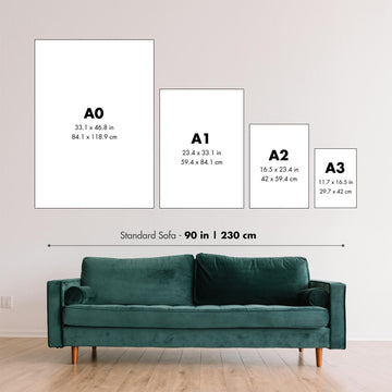
1. Select your size
2. Frame & personalize your art
Make your art unique with framing, hand-drawn customisation, vintage ageing, pop art text, unique 3D styling and moreMessage cadeau & finition personnalisée

Si vous souhaitez ajouter un message cadeau, ou une finition (puzzle, panneau en aluminium, etc.) qui n'est pas disponible ici, veuillez le demander dans la "note de commande" lors de votre passage à la caisse.
Chaque commande est fabriquée sur mesure, donc si vous avez besoin d'ajuster légèrement la taille, ou d'imprimer sur un matériau inhabituel, faites-le nous savoir. Nous avons réalisé des milliers de commandes personnalisées au fil des ans, donc il n'y a (presque) rien que nous ne puissions gérer.
Vous pouvez également nous contacter avant de passer votre commande, si vous le souhaitez !

- Handmade locally. No import duty or tax
- FREE Delivery. Arrives in 2-3 days
- Love it or your money back
- Questions? WhatsApp me any time
Own a piece of history
5,000+ 5 star reviews


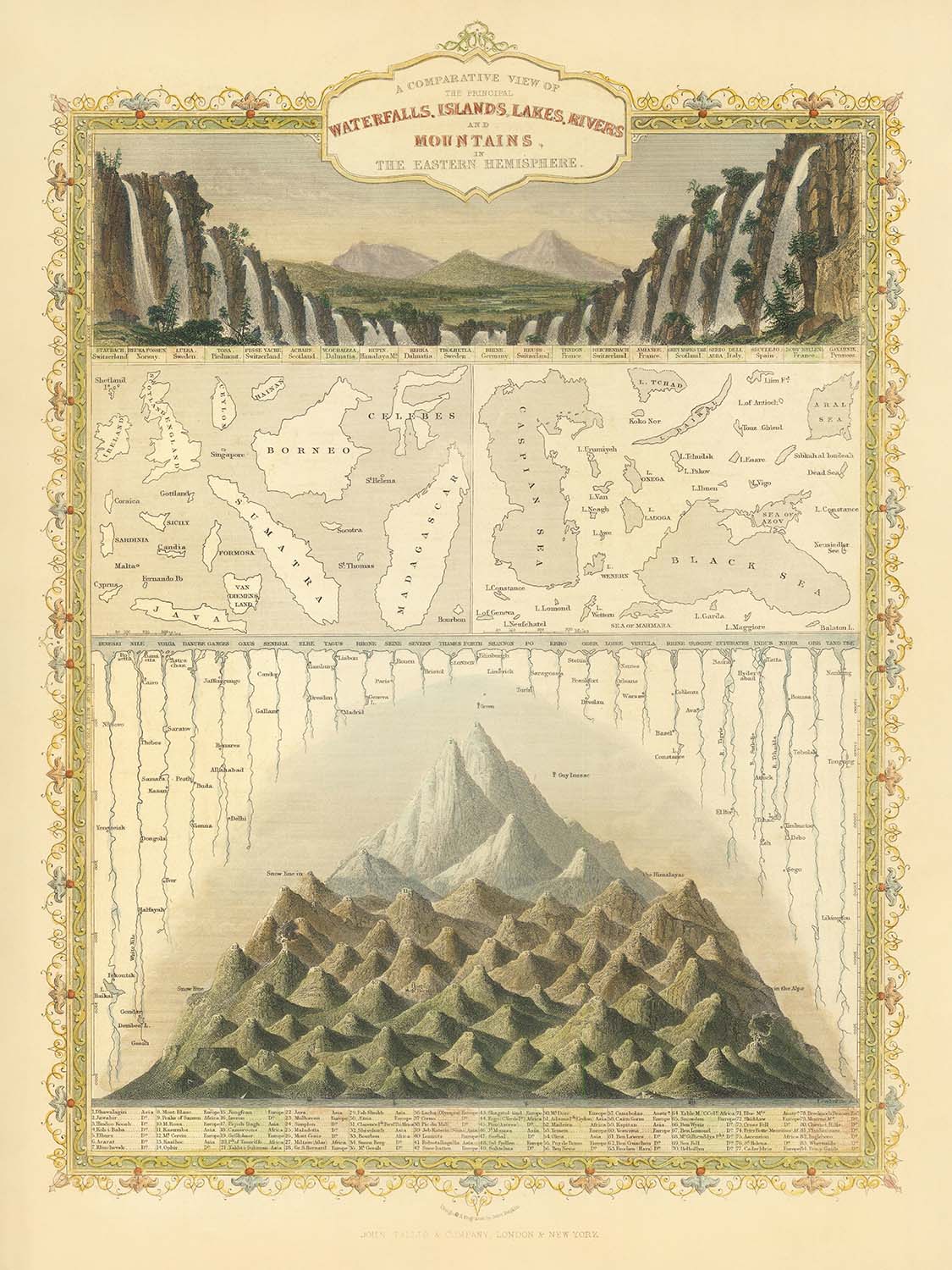
Entrez dans le monde de la découverte de l'époque victorienne avec "A Comparative View of the Principal Waterfalls, Islands, Lakes, Rivers, and Mountains in the Eastern Hemisphere" de John Tallis, une carte infographique magistrale publiée pour la première fois en 1851. Cette œuvre remarquable invite les spectateurs à explorer la grandeur des merveilles de la nature, en disposant habilement les plus hautes montagnes, les plus longs fleuves, les lacs les plus vastes et les plus grandes îles côte à côte pour une comparaison visuelle directe. Plutôt que de s'en tenir à un placement géographique, Tallis adopte une approche thématique, permettant à l'observateur de saisir immédiatement l'échelle et la majesté de chaque caractéristique, une véritable célébration de la curiosité scientifique et de l'art cartographique du XIXe siècle.
Au sommet de la carte, vingt et un des chutes d'eau les plus renommées d'Europe sont représentées en cascade, chacune soigneusement étiquetée et illustrée. Cette comparaison visuelle frappante met non seulement en évidence les hauteurs relatives et la beauté de ces merveilles naturelles, mais reflète également la fascination de l'époque pour le catalogage et le classement des merveilles du monde. Les chutes d'eau, telles que Staubbach et Schaffhausen, sont rendues avec un détail exquis, incarnant l'esprit romantique de l'époque et la précision pour laquelle les gravures de Tallis sont célèbres.
En dessous des chutes d'eau, la carte passe à une exposition captivante des plus grandes îles et mers intérieures du monde. Ici, le spectateur est traité aux similitudes surprenantes en échelle entre des masses terrestres comme Madagascar et le Royaume-Uni, et d'immenses étendues d'eau telles que la mer Caspienne et la mer d'Aral. En juxtaposant ces caractéristiques, Tallis fournit un moyen éducatif et visuellement engageant de comprendre l'immensité et la diversité de la géographie de l'hémisphère oriental, une approche qui était à la fois innovante et influente dans l'histoire des infographies cartographiques.
La section des rivières et des montagnes démontre encore l'engagement de Tallis envers l'exactitude scientifique et l'émerveillement. Les grandes rivières telles que le Yangtsé et le Yenisey sont montrées en longueur comparative, avec la source et l'altitude du Nil soigneusement notées. Les plus hauts sommets de l'hémisphère oriental, y compris l'Himalaya et le mont Ararat, se dressent majestueusement, avec les élévations et la ligne de neige soigneusement indiquées. Notamment, la carte enregistre également les altitudes les plus élevées atteintes par les pionniers des montgolfières Gay-Lussac et Biot, capturant l'esprit d'exploration et de réalisation technologique de l'époque.
Le style décoratif de John Tallis est indéniable, mêlant des données scientifiques précises à de riches embellissements artistiques. La carte est ornée de vignettes détaillées de peuples autochtones, d'animaux et d'artefacts, offrant des aperçus des cultures et des environnements entourant ces merveilles naturelles. En tant que l'un des derniers grands cartographes décoratifs, le travail de Tallis est prisé non seulement pour sa valeur éducative mais aussi pour sa beauté et son importance historique. Cette carte est un témoignage de la passion victorienne pour la découverte, la comparaison et l'art de la cartographie à son plus élégant.
Endroits sur cette carte
- Chutes d'eau d'Europe (21 chutes nommées, telles que Staubbach, Schaffhausen, Terni, etc.)
- Madagascar (île)
- Borneo
- Mer Caspienne (mer intérieure)
- Royaume-Uni (île)
- Mer d'Aral (mer intérieure)
- Rivière Yangtsé (Chang Jiang)
- Rivière Yenisey
- Rivière Nil (source et altitude notées)
- Montagnes de l'Himalaya (y compris des sommets tels que Dhaulagiri, etc.)
- Mont Ararat
- Mont Etna
- Mont Elbrus
- Mont Olympe
- Mont Sinaï
- Mont Liban
- Mont Kenya
- Mont Kilimandjaro
- Mont Cameroun
- Mont Ophir
- Mont Kosciuszko
- Lac Baïkal
- Lac Victoria
- Lac Tanganyika
- Sites de montée en montgolfière (par exemple, le vol de Gay-Lussac et Biot)
- Ligne de neige (comme marqué sur les montagnes)
- Vignettes diverses représentant des régions ou des peuples associés aux caractéristiques ci-dessus
Caractéristiques et monuments notables
- 21 principales chutes d'eau d'Europe, illustrées en haut de la carte
- Illustrations comparatives des grandes îles, y compris Madagascar et le Royaume-Uni
- Illustrations comparatives des grandes mers intérieures, telles que la mer Caspienne et la mer d'Aral
- Principaux fleuves de l'hémisphère oriental, y compris le Yangtsé et l'Enseï, montrés et étiquetés par longueur
- Les plus hautes montagnes de l'hémisphère oriental, représentées avec leurs altitudes
- La ligne de neige indiquée sur les illustrations des montagnes
- La plus haute altitude atteinte par des montgolfières, y compris l'ascension de Gay-Lussac et Biot
- Vignettes décoratives de peuples autochtones, d'animaux et d'artefacts
- Gravures artistiques et colorisation typiques du style de Tallis
- Étiquettes pour chaque caractéristique naturelle, y compris noms et mesures (hauteur, longueur, superficie, etc.)
- L'arrangement des caractéristiques pour une comparaison visuelle directe, plutôt que pour une précision géographique
- Le titre de la carte et la bordure décorative
- Référence à la source du Nil et son altitude
- La carte se concentre uniquement sur l'hémisphère oriental
- Inclusion des réalisations naturelles et scientifiques (par exemple, ascensions en montgolfière)
- La carte fait partie d'une série ou d'un atlas (Atlas illustré de R. Montgomery Martin)
- Gravures détaillées de paysages associés aux caractéristiques représentées
- Utilisation de la couleur pour distinguer les différents types de caractéristiques (chutes d'eau, îles, rivières, montagnes)
- La carte est un produit des traditions cartographiques et artistiques européennes du milieu du XIXe siècle
Contexte historique et de design
- Nom de la carte : Une vue comparative des principales chutes d'eau, îles, lacs, rivières et montagnes de l'hémisphère oriental
- Date de création : 1851
- Cartographe / Éditeur : John Tallis, gravé pour l'Atlas illustré de R. Montgomery Martin
- Type de carte : Infographique, thématique et picturale
- Objectif : Comparer visuellement les plus grandes et les plus significatives caractéristiques naturelles - chutes d'eau, îles, lacs, rivières et montagnes - de l'hémisphère oriental
- Style de design : Gravé de manière décorative, avec des illustrations en couleur et des vignettes détaillées ; caractéristique de l'art cartographique du milieu du XIXe siècle
- Contexte historique : Produit pendant une période d'exploration européenne intense, de curiosité scientifique et d'expansion impériale
- Contexte du cartographe : John Tallis était l'un des derniers grands cartographes décoratifs, renommé pour ses gravures artistiques et détaillées
- Focus thématique : Géographie comparative - montrant les tailles et hauteurs relatives des caractéristiques naturelles plutôt que leurs emplacements géographiques
- Approche infographique : Les caractéristiques sont disposées côte à côte pour une comparaison visuelle facile, et non selon leurs positions géographiques réelles
- Cartographie comparative : Partie d'un genre populaire au XIXe siècle, où les caractéristiques naturelles étaient comparées visuellement pour aider à la compréhension
- But de l'éducation : Destiné à informer et éduquer les spectateurs sur l'échelle et la grandeur des merveilles naturelles du monde
- Importance historique : Réflète à la fois les connaissances scientifiques et les sensibilités artistiques du milieu du 19ème siècle
- Données transmises : Hauteurs relatives des montagnes et des cascades, longueurs des rivières et superficies des îles et des mers
- Impact visuel : L'agencement permet aux spectateurs de saisir immédiatement les différences d'échelle entre les éléments
- Collectibilité : Les cartes Tallis sont prisées pour leur beauté, leur détail et leur valeur historique
- Limitations : La carte reflète les connaissances géographiques et l'exactitude des mesures des années 1850, qui peuvent différer des données modernes
- Contexte culturel : Les vignettes et illustrations offrent un aperçu des perceptions européennes du 19ème siècle sur le monde plus large
- Héritage : Un exemple important de cartographie infographique et de cartographie décorative de l'ère victorienne
Veuillez vérifier les images pour vous assurer qu'une ville ou un lieu spécifique est montré sur cette carte. Vous pouvez également nous contacter et nous demander de vérifier la carte pour vous.
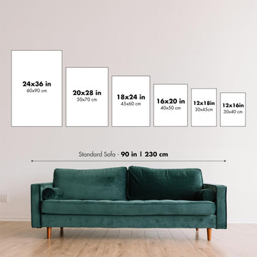
Cette carte a fière allure à toutes les tailles, mais je recommande toujours d'opter pour une taille plus grande si vous avez de l'espace. Ainsi, vous pouvez facilement distinguer tous les détails.
Cette carte est incroyable à des tailles allant jusqu'à 50 pouces (125 cm). Si vous recherchez une carte plus grande, veuillez nous contacter.
Le modèle sur les images de la liste tient la version 18x24 pouces (45x60 cm) de cette carte.
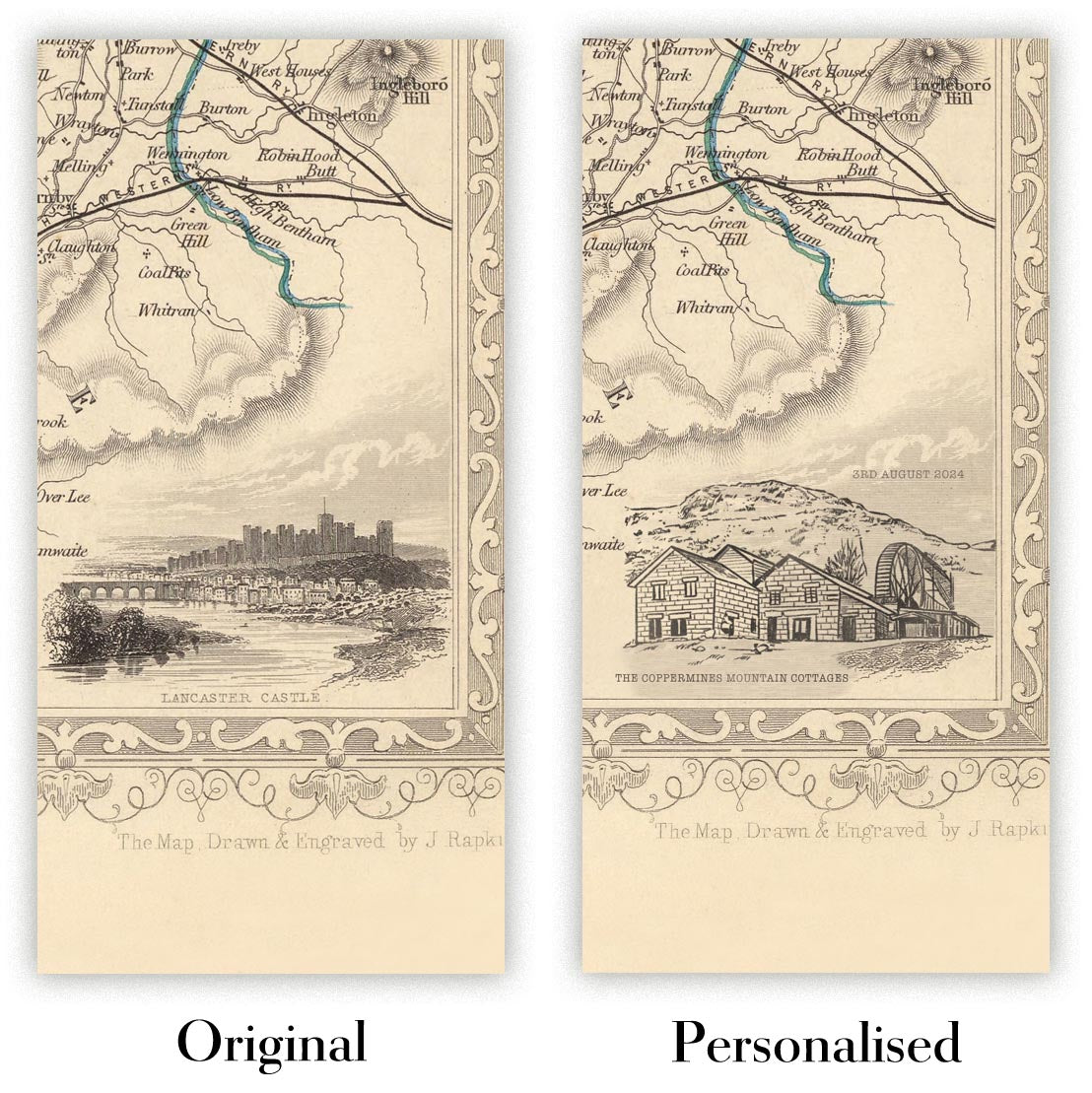
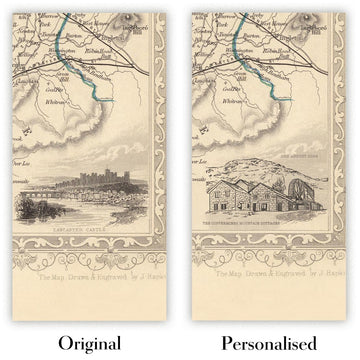
La cinquième image de la liste montre un exemple de mon service de personnalisation de carte.
Si vous recherchez quelque chose de légèrement différent, consultez ma collection des meilleures anciennes cartes pour voir si quelque chose d'autre attire votre attention.
Veuillez me contacter pour vérifier si un certain emplacement, monument ou caractéristique est montré sur cette carte.
Cela ferait un merveilleux cadeau d'anniversaire, de Noël, pour la fête des pères, un départ au travail, un anniversaire de mariage ou une pendaison de crémaillère pour quelqu'un des régions couvertes par cette carte.
Cette carte est disponible en tant qu'impression giclée sur papier mat d'archivage sans acide, ou vous pouvez l'acheter encadrée. Le cadre est un simple cadre noir qui convient à la plupart des esthétiques. Veuillez nous contacter si vous souhaitez une couleur ou un matériau de cadre différent. Mes cadres sont vitrées avec un acrylique de musée super clair (perspex/acrylite), qui est significativement moins réfléchissant que le verre, plus sûr, et arrivera toujours en parfait état.
This artwork is also available as a float framed canvas, sometimes known as a shadow gap framed canvas or canvas floater. The work is printed on artist's cotton canvas and then stretched over a handmade box frame. We then "float" the canvas inside a wooden frame, which is available in a range of colours (black, dark brown, oak, antique gold and white). This is a wonderful way to present an art print without glazing in front. See some examples of float framed canvas art and explore the differences between my different finishes.
Pour la plupart des commandes, le délai de livraison est d'environ 3 jours ouvrables. Les produits personnalisés et sur mesure prennent plus de temps, car je dois faire la personnalisation et vous l'envoyer pour approbation, ce qui prend généralement 1 ou 2 jours.
Veuillez noter que les grandes commandes encadrées prennent généralement plus de temps à réaliser et à livrer.
Si vous avez besoin que votre commande arrive à une date précise, veuillez me contacter avant de passer votre commande afin que nous puissions trouver le meilleur moyen de nous assurer que vous receviez votre commande à temps.
J'imprime et encadre des cartes et des œuvres d'art dans 23 pays à travers le monde. Cela signifie que votre commande sera réalisée localement, ce qui réduit le temps de livraison et garantit qu'elle ne sera pas endommagée pendant le transport. Vous ne paierez jamais de droits de douane ou d'importation, et nous mettrons moins de CO2 dans l'air.
Toutes mes cartes et impressions artistiques sont bien emballées et envoyées dans un tube robuste si non encadrées, ou entourées de mousse si encadrées.
J'essaie d'envoyer toutes les commandes dans les 1 ou 2 jours suivant la réception de votre commande, bien que certains produits (comme les masques, les mugs et les sacs fourre-tout) puissent prendre plus de temps à réaliser.
Si vous choisissez Livraison Express lors du paiement, nous donnerons la priorité à votre commande et l'enverrons par un service de messagerie de 1 jour (Fedex, DHL, UPS, Parcelforce).
La livraison le lendemain est également disponible dans certains pays (États-Unis, Royaume-Uni, Singapour, Émirats Arabes Unis), mais veuillez essayer de commander tôt dans la journée afin que nous puissions l'envoyer à temps.
Lisez mon guide complet sur la livraison et la production locale
Mon cadre standard est un cadre en bois dur noir de style galerie. Il est simple et a un aspect assez moderne. Mon cadre standard mesure environ 20 mm (0,8 po) de large.
J'utilise de l'acrylique super clair (perspex/acrylite) pour le verre du cadre. C'est plus léger et plus sûr que le verre - et cela a meilleur aspect, car la réflexivité est plus faible.
Six couleurs de cadre standard sont disponibles gratuitement (noir, marron foncé, gris foncé, chêne, blanc et or antique). Des encadrements et montages/matelassages personnalisés sont disponibles si vous recherchez autre chose.
La plupart des cartes, œuvres d'art et illustrations sont également disponibles sous forme de toile encadrée. Nous utilisons une toile en coton mate (non brillante), que nous tendons sur un cadre en bois de boîte provenant de sources durables, puis nous 'flottions' la pièce à l'intérieur d'un cadre en bois. Le résultat final est assez beau, et il n'y a pas de vitrage qui gêne.
Tous les cadres sont fournis "prêts à accrocher", avec soit une corde, soit des supports à l'arrière. Les très grands cadres auront des plaques de suspension lourdes et/ou une latte de montage. Si vous avez des questions, veuillez nous contacter.
Voir quelques exemples de mes cartes encadrées et de cartes en toile encadrées.
Alternativement, je peux également fournir de vieilles cartes et œuvres d'art sur toile, sur panneau en mousse, en coton et d'autres matériaux.
Si vous souhaitez encadrer votre carte ou œuvre d'art vous-même, veuillez lire d'abord mon guide des tailles.
Certaines de mes anciennes cartes sont maintenant disponibles en tant que toiles encadrées. Veuillez me contacter si vous souhaitez commander une taille qui n'est pas disponible dans ma boutique.
Les anciennes cartes en toile sont une alternative intéressante aux cartes encadrées de manière conventionnelle. En fonction de vos goûts personnels et de la décoration de votre pièce, les cartes en toile peuvent "se démarquer" un peu plus qu'une carte encadrée.
Mes cartes sont des reproductions de cartes originales de très haute qualité.
Je recherche des cartes originales et rares auprès de bibliothèques, de maisons de ventes aux enchères et de collections privées du monde entier, je les restaure dans mon atelier de Londres, puis j'utilise des encres et des imprimantes giclées spécialisées pour créer de magnifiques cartes encore plus belles que l'originale.
Mes cartes sont imprimées sur du papier d’archives mat (non brillant) sans acide qui semble de très haute qualité et ressemble presque à une carte. En termes techniques, le grammage/épaisseur du papier est de 10 mil/200 g/m². C'est parfait pour l'encadrement.
J’imprime avec des encres pigmentaires Epson ultrachrome giclée UV résistantes à la décoloration – certaines des meilleures encres que vous puissiez trouver.
je peux aussi faire cartes sur toile, chiffon en coton et autres matériaux exotiques.
En savoir plus sur Unique Maps Co..
Personnalisation de la carte
Si vous recherchez le cadeau parfait pour un anniversaire ou une pendaison de crémaillère, je peux personnaliser votre carte pour la rendre vraiment unique. Par exemple, je peux ajouter un court message, mettre en évidence un lieu important ou ajouter les armoiries de votre famille.
Les options sont presque infinies. S'il vous plaît voir mon page de personnalisation de la carte pour quelques merveilleux exemples de ce qui est possible.
Pour commander une carte personnalisée, sélectionnez « personnaliser votre carte » avant de l'ajouter à votre panier.
Entrer en contact si vous recherchez des personnalisations et des personnalisations plus complexes.
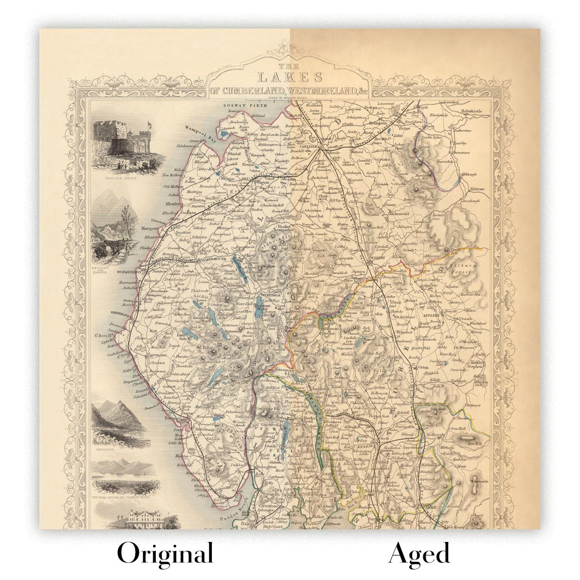
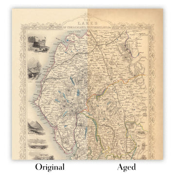
Vieillissement de la carte
Au fil des ans, des clients m'ont demandé des centaines de fois s'ils pouvaient acheter une carte qui semble uniforme. plus vieux.
Eh bien, vous pouvez désormais le faire en sélectionnant Aged avant d'ajouter une carte à votre panier.
Toutes les photos de produits que vous voyez sur cette page montrent la carte dans sa forme originale. Voilà à quoi ressemble la carte aujourd'hui.
Si vous sélectionnez Vieilli, je vieillirai votre carte à la main, en utilisant un processus spécial et unique développé au cours d'années d'étude de cartes anciennes, de discussions avec des chercheurs pour comprendre la chimie du vieillissement du papier, et bien sûr... beaucoup de pratique !
Si vous n'êtes pas sûr, respectez la couleur originale de la carte. Si vous voulez quelque chose d'un peu plus sombre et plus vieux à la recherche, optez pour Aged.
Si vous n'êtes pas satisfait de votre commande pour une raison quelconque, contactez-moi pour un remboursement sans conditions. Veuillez consulter notre politique de retours et de remboursements pour plus d'informations.
Je suis très confiant que vous aimerez votre carte restaurée ou votre impression artistique. Je fais cela depuis 1984. Je suis un vendeur Etsy 5 étoiles. J'ai vendu des dizaines de milliers de cartes et d'impressions artistiques et j'ai plus de 5 000 vrais avis 5 étoiles.
J'utilise un processus unique pour restaurer des cartes et des œuvres d'art qui est extrêmement chronophage et exigeant en main-d'œuvre. Trouver les cartes et illustrations originales peut prendre des mois. J'utilise une technologie de pointe et incroyablement coûteuse pour les numériser et les restaurer. En conséquence, je garantis que mes cartes et impressions artistiques sont d'une qualité supérieure - c'est pourquoi je peux offrir un remboursement sans conditions.
Presque toutes mes cartes et impressions artistiques ont l'air incroyables en grandes tailles (200 cm, 6,5 pieds+) et je peux également les encadrer et vous les livrer, via un transporteur spécial surdimensionné. Contactez-moi pour discuter de vos besoins spécifiques.


