


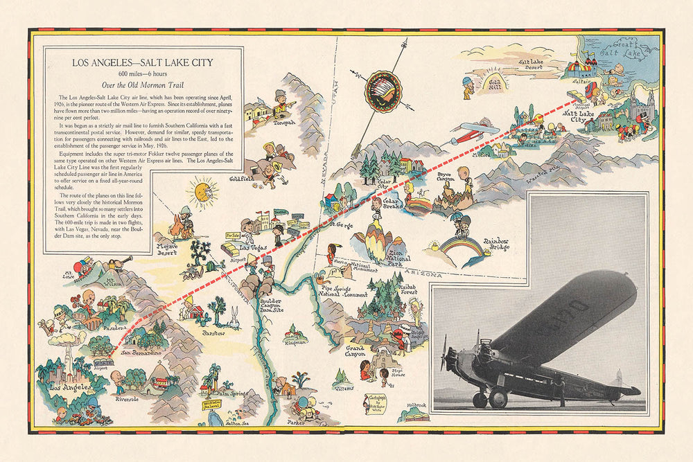


Carte picturale de la route aérienne Los Angeles–Salt Lake City, 1929: Western Air Express, Fokker tri-moteur, Las Vegas, Grand Lac Salé, Parc national de Zion
Achetez 2, obtenez 1 gratuit
Si vous ajoutez 2 articles à votre panier, vous pouvez ajouter un troisième produit gratuitement.
Cela fonctionne pour toutes les cartes et œuvres d'art, y compris les pièces personnalisées et sur mesure. Vous pouvez commander 3 de la même chose, ou 3 choses différentes.
Cela équivaut à une remise de 33 %, qui sera la plus grande remise disponible dans ma boutique cette année.
Veuillez profiter de l'offre et couvrir vos murs de belles cartes et œuvres d'art !
Contactez-moi si vous avez des questions.
-
![]() Handmade in the USA
Handmade in the USA

-
FREE worldwide delivery in 2-3 days ⓘ
Free delivery in 2-3 days
Your map should be delivered in 2-3 working days with free delivery, worldwide.
We make maps by hand locally in 23 countries. If you're buying a gift for someone in another country, we will make the map locally to them.
You will never pay import tax or customs duty.
Express delivery is available at checkout which can reduce the delivery time to 1-2 days.
Please note that personalised maps, and larger framed maps, can take longer to produce and deliver.
If you need your order to arrive by a certain date, contact me and we can discuss your options.
-
Complimentary gifting & design advice
ⓘ
Complimentary gifting & design advice
Available almost 24/7 on WhatsApp and email — we usually reply within minutes. We can help you:
- Choose a perfectly personalised gift
- Send a digital gift preview to the recipient
- Pick the ideal size for your wall
- Select the right finish and frame
Quick, friendly advice so you can order with confidence.
For last minute gifts, consider buying a digital gift card. We have over 5,000 maps and art prints to choose from.
-
90-day returns & 5-year guarantee
ⓘ
90 jours pour retourner et obtenir un remboursement
Les produits peuvent être retournés dans les 90 jours pour un remboursement complet, ou un échange contre un autre produit.
Pour les articles personnalisés et faits sur mesure, nous pouvons vous offrir un crédit en magasin ou une carte-cadeau non expirante, car nous ne pouvons pas revendre les commandes personnalisées.
Si vous avez des questions, contactez-nous. Pour plus d'informations, consultez notre politique de retours et d'échanges.

This is a museum-grade archival print from the original 1929 map — restored in our workshop and made to order on 220gsm archival matte paper or 400gsm artist's cotton canvas with pigment inks.
Professional framing & free personalisation available
1. Choose a size
2. Frame & personalize your map
Make your map unique with framing, hand-drawn customisation, vintage ageing, pop art text, unique 3D styling and more.


Message cadeau & finition personnalisée

Si vous souhaitez ajouter un message cadeau, ou une finition (puzzle, panneau en aluminium, etc.) qui n'est pas disponible ici, veuillez le demander dans la "note de commande" lors de votre passage à la caisse.
Chaque commande est fabriquée sur mesure, donc si vous avez besoin d'ajuster légèrement la taille, ou d'imprimer sur un matériau inhabituel, faites-le nous savoir. Nous avons réalisé des milliers de commandes personnalisées au fil des ans, donc il n'y a (presque) rien que nous ne puissions gérer.
Vous pouvez également nous contacter avant de passer votre commande, si vous le souhaitez !

- Handmade locally. No import duty or tax
- FREE worldwide delivery
- 90-day returns & 5-year product guarantee
- Questions? WhatsApp me any time
Own a piece of history
7,000+ 5 star reviews


Entrez dans l'âge d'or de l'aviation avec cette carte picturale captivante de 1929, "Los Angeles-Salt Lake City," magistralement illustrée par Ruth Taylor White. Commandée par Western Air Express, cette carte a été créée à un moment clé de l'histoire américaine, lorsque le voyage aérien commercial commençait à redéfinir le sens de la distance et de l'aventure dans le pays. L'art de White capture non seulement la merveille technique d'un vol de 600 miles à travers l'Ouest américain, mais aussi l'esprit d'optimisme et d'innovation qui a défini l'époque. Le trajet lui-même, s'étendant de la métropole animée de Los Angeles au cœur culturel de Salt Lake City, est rendu avec un œil attentif tant pour l'exactitude géographique que pour le récit visuel.
Ce qui distingue cette carte, c'est son riche contenu thématique et son style pictural engageant. Plutôt qu'un simple outil de navigation, c'est une célébration vivante des paysages, des villes et des opportunités récréatives qui attendaient le voyageur moderne. Les illustrations de White donnent vie aux chaînes de montagnes dramatiques, aux forêts luxuriantes et aux rivières scintillantes qui définissent la région. Des vignettes picturales de skieurs, de nageurs et de cavaliers parsèment le paysage, mettant en avant la variété d'activités de loisirs accessibles le long du parcours. Ce n'est pas juste une carte—c'est une invitation à explorer, rêver et vivre l'Ouest tel qu'il était vu depuis le cockpit d'un avion Fokker à trois moteurs.
Historiquement, cette carte se dresse comme un témoignage de la transformation rapide des voyages et du tourisme à la fin des années 1920. Western Air Express, dont le logo en flèche audacieuse et le slogan "Voyagez par avion" sont fièrement affichés, était à l'avant-garde de la rendre le voyage aérien accessible et attrayant pour le public. L'inclusion des temps de vol, des distances et des points de passage clés—tels que Las Vegas, Cedar City et le Grand Lac Salé, impressionnant—souligne la fascination de l'époque pour la vitesse, l'efficacité et la modernité. Elle offre un aperçu rare des premiers jours de l'aviation commerciale, lorsque chaque vol était une aventure et chaque destination une nouvelle frontière.
Le mérite artistique du travail de Ruth Taylor White est évident dans chaque détail. Son utilisation des couleurs, de l'ombre en relief et des illustrations ludiques transforme la carte en un tableau vivant, où les merveilles naturelles de la Sierra Nevada, du désert de Mojave et des parcs nationaux de l'Utah font autant partie du voyage que les villes elles-mêmes. Chaque lieu—qu'il s'agisse des rues animées de Los Angeles, de l'immense sérénité du Bryce Canyon ou du charme historique de St. George—est dépeint avec affection et style. Le format en double page de la carte permet une vue panoramique qui immerge le spectateur dans la grandeur du paysage occidental.
Les collectionneurs et les passionnés d'histoire apprécieront le double rôle de la carte en tant que guide pratique et pièce d'histoire culturelle. Elle encapsule un moment où le voyage aérien était nouveau, glamour et transformateur, changeant à jamais la manière dont les Américains expérimentaient leur pays. Avec sa combinaison de signification historique, de brillance artistique et de narration évocatrice, cette carte n'est pas simplement un vestige du passé—c'est une célébration d'une époque où le ciel était vraiment la limite.
Endroits sur cette carte
- Los Angeles, Californie
- Salt Lake City, Utah
- Las Vegas, Nevada
- San Bernardino, Californie
- Barstow, Californie
- Caliente, Nevada
- Cedar City, Utah
- Grand Lac Salé, Utah
- Désert de Mojave, Californie/Nevada
- Montagnes de la Sierra Nevada
- Rivière Colorado
- Montagnes de San Gabriel
- San Fernando Valley, Californie
- Victorville, Californie
- St. George, Utah
- Parowan, Utah
- Panguitch, Utah
- Kanab, Utah
- Parc national de Zion, Utah
- Canyon de Bryce, Utah
Caractéristiques et monuments notables
- La route aérienne de Los Angeles à Salt Lake City, clairement marquée
- Illustration d'un avion Fokker à trois moteurs survolant le paysage
- Le logo de Western Air Express (flèche) et le slogan « Voyagez par air »
- Représentations picturales des chaînes de montagnes le long de la route
- Rivières et lacs illustrés le long du parcours aérien
- Activités récréatives représentées, y compris le ski, la natation et l'équitation
- Zones forestières et parcs nationaux montrés picturalement
- Petites villes et points de repère étiquetés le long de la route
- Accent visuel sur le terrain dramatique, en particulier les cols de montagne
- Figures de style cartoon s'engageant dans des loisirs et des sports
- Distances et temps de vol estimés entre les points clés
- Bordure décorative avec illustrations thématiques
- Monuments clés et caractéristiques naturelles, comme la Sierra Nevada et le Grand Lac Salé, illustrés
- Indices visuels pour les attractions touristiques d'été et d'hiver
- L'orientation de la carte est en paysage, s'étendant sur deux pages
- Utilisation de couleurs vives et engageantes typiques du style de Ruth Taylor White
- Ombres de relief pour indiquer l'élévation et les zones montagneuses
- Route aérienne montrée comme une ligne ou une flèche audacieuse à travers la carte
- Principales rivières, comme le fleuve Colorado, représentées
- La carte inclut à la fois des caractéristiques urbaines et rurales, soulignant la diversité du paysage
Contexte historique et de conception
- Créée en 1929 par Ruth Taylor White, une illustratrice et cartographe américaine renommée
- Commandée par Western Air Express pour promouvoir le voyage aérien commercial précoce
- Révèle la culture aéronautique émergente et l'expansion des routes aériennes commerciales à la fin des années 1920
- Serre à la fois d'outil promotionnel et de pièce de culture visuelle de l'époque
- Fournit un aperçu de l'aviation commerciale précoce et de son impact sur la connectivité régionale et le tourisme
- Le style pictural vibrant et dessiné à la main de la carte donne vie à la fois à l'exactitude géographique et au flair artistique
- Met en avant la nouveauté et l'excitation du voyage aérien comme une alternative moderne et efficace aux voyages en train ou en automobile
- Inclut des détails pratiques tels que les temps de vol et les distances, attirant les touristes et les premiers voyageurs aériens
- Fait partie d'une publication plus large qui incluait des informations touristiques et des index pour plusieurs routes aériennes de l'Ouest américain
- Offre un rare aperçu des débuts du voyage aérien américain, lorsque chaque vol était une aventure
Veuillez vérifier les images pour vous assurer qu'une ville ou un lieu spécifique est montré sur cette carte. Vous pouvez également nous contacter et nous demander de vérifier la carte pour vous.
Cette carte est magnifique à toutes les tailles, mais je recommande toujours d'opter pour une taille plus grande si vous avez de l'espace. De cette façon, vous pouvez facilement distinguer tous les détails.
Cette carte est incroyable à des tailles allant jusqu'à 70in (180cm). Si vous recherchez une carte plus grande, veuillez nous contacter.
Le modèle sur les images de la liste tient la version 24x36in (60x90cm) de cette carte.
L'image de la cinquième liste montre un exemple de mon service de personnalisation de carte.
Si vous cherchez quelque chose de légèrement différent, consultez ma collection des meilleures anciennes cartes pour voir si quelque chose d'autre attire votre attention.
Veuillez me contacter pour vérifier si un certain emplacement, monument ou caractéristique est représenté sur cette carte.
Cela ferait un merveilleux cadeau d'anniversaire, de Noël, pour la fête des pères, un départ en retraite, un anniversaire de mariage ou une pendaison de crémaillère pour quelqu'un des régions couvertes par cette carte.
Cette carte est disponible en tant qu'impression giclée sur du papier mat d'archive sans acide, ou vous pouvez l'acheter encadrée. Le cadre est un joli et simple cadre noir qui convient à la plupart des esthétiques. Veuillez me contacter si vous souhaitez une couleur ou un matériau de cadre différent. Mes cadres sont vitrées avec un acrylique de musée super clair (perspex/acrylite), qui est significativement moins réfléchissant que le verre, plus sûr, et arrivera toujours en parfait état.
This map is also available as a float framed canvas, sometimes known as a shadow gap framed canvas or canvas floater. The map is printed on artist's cotton canvas and then stretched over a handmade box frame. We then "float" the canvas inside a wooden frame, which is available in a range of colours (black, dark brown, oak, antique gold and white). This is a wonderful way to present a map without glazing in front. See some examples of float framed canvas maps and explore the differences between my different finishes.
For something truly unique, this map is also available in "Unique 3D", our trademarked process that dramatically transforms the map so that it has a wonderful sense of depth. We combine the original map with detailed topography and elevation data, so that mountains and the terrain really "pop". For more info and examples of 3D maps, check my Unique 3D page.
Pour la plupart des commandes, le délai de livraison est d'environ 3 jours ouvrables. Les produits personnalisés et sur mesure prennent plus de temps, car je dois faire la personnalisation et vous l'envoyer pour approbation, ce qui prend généralement 1 ou 2 jours.
Veuillez noter que les grandes commandes encadrées prennent généralement plus de temps à réaliser et à livrer.
Si vous avez besoin que votre commande arrive à une date précise, veuillez me contacter avant de passer votre commande afin que nous puissions trouver le meilleur moyen de nous assurer que vous receviez votre commande à temps.
J'imprime et encadre des cartes et des œuvres d'art dans 23 pays à travers le monde. Cela signifie que votre commande sera réalisée localement, ce qui réduit le temps de livraison et garantit qu'elle ne sera pas endommagée pendant le transport. Vous ne paierez jamais de droits de douane ou d'importation, et nous mettrons moins de CO2 dans l'air.
Toutes mes cartes et impressions artistiques sont bien emballées et envoyées dans un tube robuste si non encadrées, ou entourées de mousse si encadrées.
J'essaie d'envoyer toutes les commandes dans les 1 ou 2 jours suivant la réception de votre commande, bien que certains produits (comme les masques, les mugs et les sacs fourre-tout) puissent prendre plus de temps à réaliser.
Si vous choisissez Livraison Express lors du paiement, nous donnerons la priorité à votre commande et l'enverrons par un service de messagerie de 1 jour (Fedex, DHL, UPS, Parcelforce).
La livraison le lendemain est également disponible dans certains pays (États-Unis, Royaume-Uni, Singapour, Émirats Arabes Unis), mais veuillez essayer de commander tôt dans la journée afin que nous puissions l'envoyer à temps.
Lisez mon guide complet sur la livraison et la production locale
Mon cadre standard est un cadre en bois dur noir de style galerie. Il est simple et a un aspect assez moderne. Mon cadre standard mesure environ 20 mm (0,8 po) de large.
J'utilise de l'acrylique super clair (perspex/acrylite) pour le verre du cadre. C'est plus léger et plus sûr que le verre - et cela a meilleur aspect, car la réflexivité est plus faible.
Six couleurs de cadre standard sont disponibles gratuitement (noir, marron foncé, gris foncé, chêne, blanc et or antique). Des encadrements et montages/matelassages personnalisés sont disponibles si vous recherchez autre chose.
La plupart des cartes, œuvres d'art et illustrations sont également disponibles sous forme de toile encadrée. Nous utilisons une toile en coton mate (non brillante), que nous tendons sur un cadre en bois de boîte provenant de sources durables, puis nous 'flottions' la pièce à l'intérieur d'un cadre en bois. Le résultat final est assez beau, et il n'y a pas de vitrage qui gêne.
Tous les cadres sont fournis "prêts à accrocher", avec soit une corde, soit des supports à l'arrière. Les très grands cadres auront des plaques de suspension lourdes et/ou une latte de montage. Si vous avez des questions, veuillez nous contacter.
Voir quelques exemples de mes cartes encadrées et de cartes en toile encadrées.
Alternativement, je peux également fournir de vieilles cartes et œuvres d'art sur toile, sur panneau en mousse, en coton et d'autres matériaux.
Si vous souhaitez encadrer votre carte ou œuvre d'art vous-même, veuillez lire d'abord mon guide des tailles.
Certaines de mes anciennes cartes sont maintenant disponibles en tant que toiles encadrées. Veuillez me contacter si vous souhaitez commander une taille qui n'est pas disponible dans ma boutique.
Les anciennes cartes en toile sont une alternative intéressante aux cartes encadrées de manière conventionnelle. Selon vos goûts personnels et la décoration de votre pièce, les cartes en toile peuvent "se démarquer" un peu plus qu'une carte encadrée.
Mes cartes sont des reproductions de cartes originales de très haute qualité.
Je recherche des cartes originales et rares auprès de bibliothèques, de maisons de ventes aux enchères et de collections privées du monde entier, je les restaure dans mon atelier de Londres, puis j'utilise des encres et des imprimantes giclées spécialisées pour créer de magnifiques cartes encore plus belles que l'originale.
Mes cartes sont imprimées sur du papier d’archives mat (non brillant) sans acide qui semble de très haute qualité et ressemble presque à une carte. En termes techniques, le grammage/épaisseur du papier est de 10 mil/200 g/m². C'est parfait pour l'encadrement.
J’imprime avec des encres pigmentaires Epson ultrachrome giclée UV résistantes à la décoloration – certaines des meilleures encres que vous puissiez trouver.
je peux aussi faire cartes sur toile, chiffon en coton et autres matériaux exotiques.
En savoir plus sur Unique Maps Co..
Personnalisation de la carte
Si vous recherchez le cadeau parfait pour un anniversaire ou une pendaison de crémaillère, je peux personnaliser votre carte pour la rendre vraiment unique. Par exemple, je peux ajouter un court message, mettre en évidence un lieu important ou ajouter les armoiries de votre famille.
Les options sont presque infinies. S'il vous plaît voir mon page de personnalisation de la carte pour quelques merveilleux exemples de ce qui est possible.
Pour commander une carte personnalisée, sélectionnez « personnaliser votre carte » avant de l'ajouter à votre panier.
Entrer en contact si vous recherchez des personnalisations et des personnalisations plus complexes.
Vieillissement de la carte
Au fil des ans, des clients m'ont demandé des centaines de fois s'ils pouvaient acheter une carte qui semble uniforme. plus vieux.
Eh bien, vous pouvez désormais le faire en sélectionnant Aged avant d'ajouter une carte à votre panier.
Toutes les photos de produits que vous voyez sur cette page montrent la carte dans sa forme originale. Voilà à quoi ressemble la carte aujourd'hui.
Si vous sélectionnez Vieilli, je vieillirai votre carte à la main, en utilisant un processus spécial et unique développé au cours d'années d'étude de cartes anciennes, de discussions avec des chercheurs pour comprendre la chimie du vieillissement du papier, et bien sûr... beaucoup de pratique !
Si vous n'êtes pas sûr, respectez la couleur originale de la carte. Si vous voulez quelque chose d'un peu plus sombre et plus vieux à la recherche, optez pour Aged.
Si vous n'êtes pas satisfait de votre commande pour une raison quelconque, contactez-moi pour un remboursement sans conditions. Veuillez consulter notre politique de retours et de remboursements pour plus d'informations.
Je suis très confiant que vous aimerez votre carte restaurée ou votre impression artistique. Je fais cela depuis 1984. Je suis un vendeur Etsy 5 étoiles. J'ai vendu des dizaines de milliers de cartes et d'impressions artistiques et j'ai plus de 5 000 vrais avis 5 étoiles.
J'utilise un processus unique pour restaurer des cartes et des œuvres d'art qui est extrêmement chronophage et exigeant en main-d'œuvre. Trouver les cartes et illustrations originales peut prendre des mois. J'utilise une technologie de pointe et incroyablement coûteuse pour les numériser et les restaurer. En conséquence, je garantis que mes cartes et impressions artistiques sont d'une qualité supérieure - c'est pourquoi je peux offrir un remboursement sans conditions.
Presque toutes mes cartes et impressions artistiques ont l'air incroyables en grandes tailles (200 cm, 6,5 pieds+) et je peux également les encadrer et vous les livrer, via un transporteur spécial surdimensionné. Contactez-moi pour discuter de vos besoins spécifiques.
Or try searching for something!


