


Mapa antiguo de la distribución de los castaños y chinquapines en EE. UU., 1884
La oferta del coleccionista
Elija dos obras elegibles y obtenga un 20 % de descuento en ambas. Elija tres y la de menor precio será gratuita, con un ahorro máximo del 33 %.
Combine y mezcle mapas estándar elegibles y reproducciones de bellas artes. No se requiere código; la oferta se aplica automáticamente al finalizar la compra.
Se incluyen las configuraciones estándar hechas por encargo. Quedan excluidos los tamaños a medida, los diseños personalizados y los trabajos por encargo.
¿Necesita entrega en diferentes direcciones? Contáctenos antes de realizar el pedido.La oferta del coleccionista
Elija dos obras elegibles y obtenga un 20 % de descuento en ambas. Elija tres y la de menor precio será gratuita, con un ahorro máximo del 33 %.
Combine y mezcle mapas estándar elegibles y reproducciones de bellas artes. No se requiere código; la oferta se aplica automáticamente al finalizar la compra.
Se incluyen las configuraciones estándar hechas por encargo. Quedan excluidos los tamaños a medida, los diseños personalizados y los trabajos por encargo.
¿Necesita entrega en diferentes direcciones? Contáctenos antes de realizar el pedido. Diseñado en Londres Hecho en the USA
Diseñado en Londres • Hecho en the USA
Diseñado en Londres Hecho en the USA
Diseñado en Londres • Hecho en the USA

Restaurado a partir del mapa original de 1884 e impreso en calidad museo. Leer la historia detrás de este mapa
Choose your size
Choose your finish


(Más información)
Mensaje de regalo y acabado personalizado

Si deseas agregar un mensaje de regalo, o un acabado (rompecabezas, tablero de aluminio, etc.) que no esté disponible aquí, por favor solicítalo en la "nota del pedido" cuando realices la compra.
Cada pedido es hecho a medida, así que si necesitas que el tamaño se ajuste ligeramente, o que se imprima en un material inusual, háznoslo saber. Hemos realizado miles de pedidos personalizados a lo largo de los años, así que hay (casi) nada que no podamos gestionar.
También puedes contactarnos antes de hacer tu pedido, ¡si lo prefieres!

- Hecho localmente. Entrega segura
- Sin aranceles ni cargos ocultos
- ¿Necesitas ayuda? Llámanos o mensaje por WhatsApp
Own a piece of history
8,000+ five-star reviews


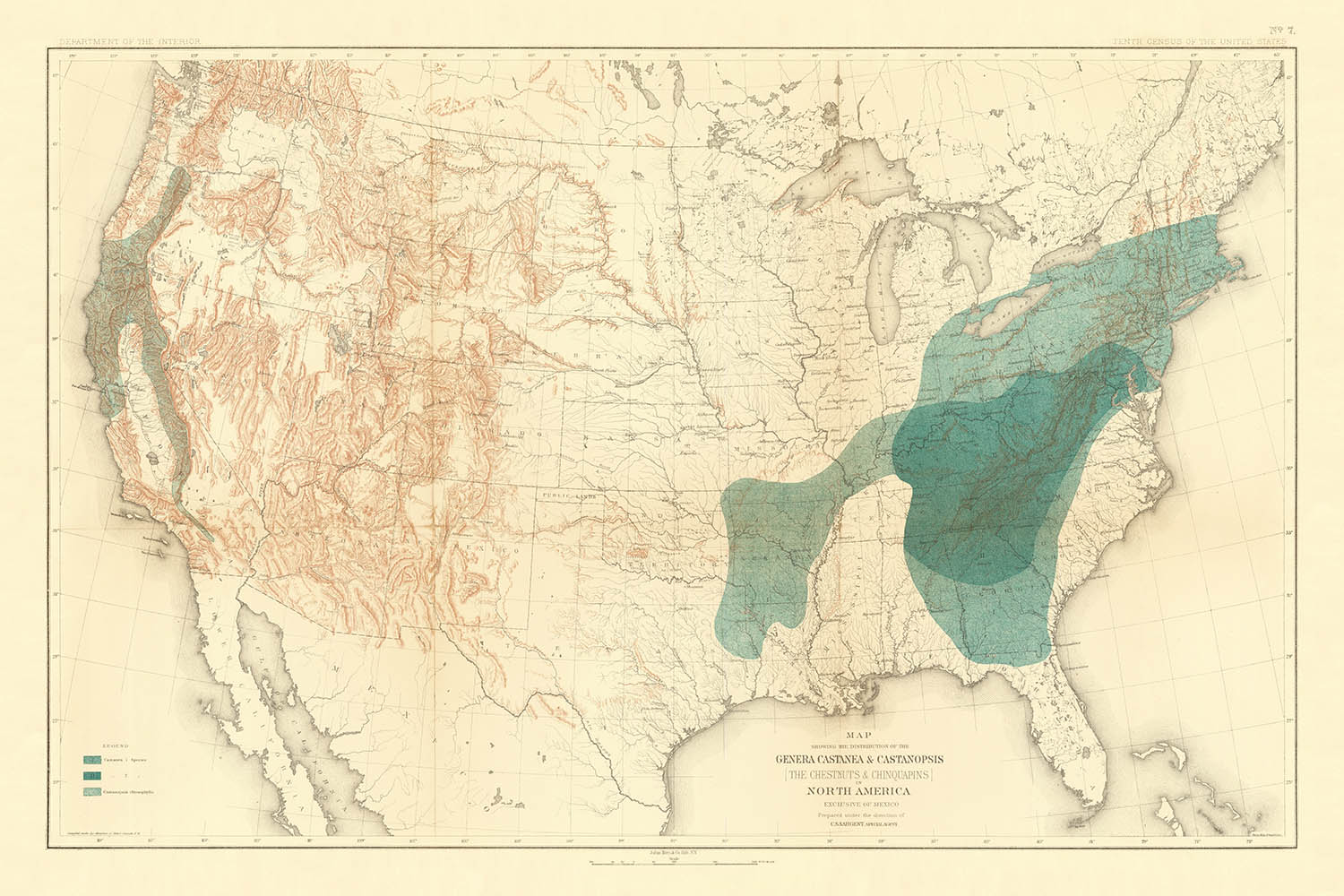
Adéntrese en el rico tapiz de la historia botánica de América del Norte con el "Map Showing the Distribution of the Genera...
Seguir leyendoAdéntrese en el rico tapiz de la historia botánica de América del Norte con el "Map Showing the Distribution of the Genera Castanea & Castanopsis (The Chestnuts & Chinquapins) in North America Exclusive of Mexico," una obra maestra preparada bajo la dirección de C.S. Sargent para el Décimo Censo de los Estados Unidos en 1884. Este extraordinario mapa temático es más que un documento científico: es una vívida instantánea de un paisaje anterior a la devastación del castaño americano, que capta el área de distribución nativa de los castaños y chinquapines en un momento decisivo de la historia ecológica. La cuidadosa delimitación de los hábitats de estos géneros revela la profunda relación entre la geografía y los antaño abundantes bosques de frondosas del continente.
Producido por la renombrada Julius Bien & Co., este mapa es testimonio de las mejores técnicas litográficas en color de la época. Julius Bien, una figura destacada de la cartografía y la litografía estadounidenses, aportó precisión científica y elegancia artística a cada proyecto. Su firma fue célebre por sus colaboraciones con científicos y organismos gubernamentales de primer nivel, lo que convierte a este mapa no solo en un recurso funcional, sino también en una joya de coleccionista. La participación del delineante Harry King y del compilador Henry Gannett, ambos figuras cruciales en la cartografía estadounidense, garantiza los más altos estándares de exactitud y detalle.
El enfoque temático del mapa en la distribución de Castanea y Castanopsis lo distingue como un artefacto singular de la historia medioambiental y económica. En una época en que el castaño americano era una especie clave en los bosques del este, este mapa ofrecía información fundamental para botánicos, silvicultores y responsables de políticas. Las regiones sombreadas, representadas con meticuloso detalle, trazan las áreas de distribución natural de estos árboles a lo largo del este de los Estados Unidos, con especial densidad a lo largo de las montañas Apalaches y la costa atlántica. Estas claves visuales invitan al espectador a explorar la interacción entre topografía, clima y diversidad botánica.
Desde el punto de vista geográfico, el mapa ofrece una visión completa de los Estados Unidos, con los límites estatales y de condados claramente delineados para proporcionar una sensación de escala y lugar. Los principales ríos, como el poderoso Misisipi y sus afluentes, recorren el paisaje, evocando las rutas de exploración y comercio que dieron forma a la nación. Las montañas Apalaches se alzan de forma prominente dentro del área de distribución del castaño, con sus contornos sutilmente sombreados para reflejar tanto la altitud como su importancia ecológica. La costa atlántica, con sus suaves curvas, enmarca el extremo oriental de estos célebres bosques.
Lo que distingue a este mapa es su enfoque singular en el mundo natural, prescindiendo del bullicio de ciudades y poblaciones en favor de una pura narración ecológica. No hay centros urbanos ni asentamientos que distraigan de la narrativa botánica; en su lugar, la mirada del espectador se dirige al amplio despliegue de la propia naturaleza. Como obra de cartografía científica, se erige a la vez como obra de arte y documento histórico, un recordatorio perdurable de un paisaje perdido y del legado duradero de los cartógrafos y botánicos que buscaron comprenderlo.
Ciudades y pueblos en este mapa
- No hay ciudades ni pueblos etiquetados o marcados en este mapa. El mapa se centra en la distribución botánica y no incluye asentamientos humanos.
Características destacadas y puntos de interés
- Sombreado de distribución: Las áreas de los Estados Unidos aparecen sombreadas o coloreadas para mostrar el área de distribución natural de los castaños y chinquapines.
- Límites estatales: Claramente marcados en todo Estados Unidos.
- Límites de condado: visibles en algunos estados, lo que proporciona un detalle geográfico más fino.
- Ríos principales: se representan varios ríos grandes, incluido el río Misisipi y sus afluentes.
- Las montañas Apalaches: la cordillera está indicada mediante sombreado y líneas topográficas, ya que esta región es significativa para la distribución de castaños.
- La costa atlántica: claramente delineada, ya que la distribución de los castaños se extiende a lo largo de esta zona.
- Fronteras: se muestra la frontera entre EE. UU. y Canadá, así como la frontera sur con México (aunque México queda excluido del área cartografiada).
Contexto histórico y de diseño
- Nombre del mapa: Map Showing the Distribution of the Genera Castanea & Castanopsis (The Chestnuts & Chinquapins) in North America Exclusive of Mexico.
- Fecha de creación: 1884.
- Cartógrafo/editor: Julius Bien & Co., una destacada firma estadounidense de litografía y cartografía del siglo XIX, conocida por sus litografías en color de alta calidad y por sus importantes contribuciones a publicaciones científicas y gubernamentales.
- Preparado bajo la dirección de C.S. Sargent, Special Agent, con dibujo a cargo de Harry King y compilación de Henry Gannett, ambos figuras notables de la cartografía estadounidense y del trabajo censal.
- Creado para: el Décimo Censo de los Estados Unidos (1880), reflejando el interés de la época por documentar los recursos naturales y los datos científicos.
- Tipo de mapa: mapa temático del país, que muestra específicamente la distribución botánica/geográfica.
- Temas: distribución de los castaños (Castanea) y de los chinquapines (Castanopsis) en América del Norte, excluido México; destaca el ámbito natural de estos géneros de árboles.
- Diseño/estilo: litografiado en color, con sombreado o coloración temática para indicar las áreas de distribución de los géneros arbóreos; típico de la cartografía científica de finales del siglo XIX.
- Importancia histórica: refleja la importancia de las especies de castaño y chinquapín en la silvicultura, la ecología y la economía de Norteamérica antes de la devastación causada por el chancro del castaño en el siglo XX; forma parte de un movimiento más amplio para documentar científicamente la flora del continente.
- Nota de contexto: el mapa es un ejemplo de cartografía científica temprana en Estados Unidos, producido para un censo federal, y ilustra la colaboración entre botánicos, cartógrafos y litógrafos.
Por favor, vuelva a comprobar las imágenes para asegurarse de que aparece una ciudad o lugar específico en este mapa. También puede ponerse en contacto con nosotros y pedirnos que revisemos el mapa por usted.
Este mapa queda estupendo en cualquier tamaño, pero siempre recomiendo optar por un tamaño mayor si dispone de espacio. Así podrá distinguir fácilmente todos los detalles.
Este mapa luce increíble en tamaños de hasta 100in (250cm). Si busca un mapa más grande, por favor póngase en contacto.
Nota: las etiquetas de este mapa son difíciles de leer si pide un mapa de 20in (50cm) o menos. El mapa sigue siendo muy atractivo, pero si desea leerlo con facilidad, por favor compre un tamaño mayor.
El modelo en las imágenes del anuncio sostiene la versión de 24x36in (60x90cm) de este mapa.
La quinta imagen del anuncio muestra un ejemplo de mi servicio de personalización de mapas.
Si busca algo ligeramente diferente, eche un vistazo a mi colección de los mejores mapas antiguos para ver si algo más le llama la atención.
Por favor contácteme para comprobar si una ubicación, un hito o una característica concretos aparecen en este mapa.
Esto haría un regalo maravilloso de cumpleaños, Navidad, Día del Padre, despedida de trabajo, aniversario o inauguración del hogar para alguien de las zonas cubiertas por este mapa.
Este mapa está disponible como impresión giclée en papel mate de archivo libre de ácido, o puede adquirirlo enmarcado. El marco es un bonito y sencillo marco negro que combina con la mayoría de los estilos. Póngase en contacto si desea un color o material de marco diferente. Mis marcos llevan un acristalamiento de acrílico de calidad museística, ultratransparente (perspex/acrylite), que es considerablemente menos reflectante que el vidrio, más seguro y siempre llegará en perfectas condiciones.
This map is also available as a float framed canvas, sometimes known as a shadow gap framed canvas or canvas floater. The map is printed on artist's cotton canvas and then stretched over a handmade box frame. We then "float" the canvas inside a wooden frame, which is available in a range of colours (black, dark brown, oak, antique gold and white). This is a wonderful way to present a map without glazing in front. See some examples of float framed canvas maps and explore the differences between my different finishes.
For something truly unique, this map is also available in "Unique 3D", our trademarked process that dramatically transforms the map so that it has a wonderful sense of depth. We combine the original map with detailed topography and elevation data, so that mountains and the terrain really "pop". For more info and examples of 3D maps, check my Unique 3D page.
Adéntrese en el rico tapiz de la historia botánica de América del Norte con el "Map Showing the Distribution of the Genera Castanea & Castanopsis (The Chestnuts & Chinquapins) in North America Exclusive of Mexico," una obra maestra preparada bajo la dirección de C.S. Sargent para el Décimo Censo de los Estados Unidos en 1884. Este extraordinario mapa temático es más que un documento científico: es una vívida instantánea de un paisaje anterior a la devastación del castaño americano, que capta el área de distribución nativa de los castaños y chinquapines en un momento decisivo de la historia ecológica. La cuidadosa delimitación de los hábitats de estos géneros revela la profunda relación entre la geografía y los antaño abundantes bosques de frondosas del continente.
Producido por la renombrada Julius Bien & Co., este mapa es testimonio de las mejores técnicas litográficas en color de la época. Julius Bien, una figura destacada de la cartografía y la litografía estadounidenses, aportó precisión científica y elegancia artística a cada proyecto. Su firma fue célebre por sus colaboraciones con científicos y organismos gubernamentales de primer nivel, lo que convierte a este mapa no solo en un recurso funcional, sino también en una joya de coleccionista. La participación del delineante Harry King y del compilador Henry Gannett, ambos figuras cruciales en la cartografía estadounidense, garantiza los más altos estándares de exactitud y detalle.
El enfoque temático del mapa en la distribución de Castanea y Castanopsis lo distingue como un artefacto singular de la historia medioambiental y económica. En una época en que el castaño americano era una especie clave en los bosques del este, este mapa ofrecía información fundamental para botánicos, silvicultores y responsables de políticas. Las regiones sombreadas, representadas con meticuloso detalle, trazan las áreas de distribución natural de estos árboles a lo largo del este de los Estados Unidos, con especial densidad a lo largo de las montañas Apalaches y la costa atlántica. Estas claves visuales invitan al espectador a explorar la interacción entre topografía, clima y diversidad botánica.
Desde el punto de vista geográfico, el mapa ofrece una visión completa de los Estados Unidos, con los límites estatales y de condados claramente delineados para proporcionar una sensación de escala y lugar. Los principales ríos, como el poderoso Misisipi y sus afluentes, recorren el paisaje, evocando las rutas de exploración y comercio que dieron forma a la nación. Las montañas Apalaches se alzan de forma prominente dentro del área de distribución del castaño, con sus contornos sutilmente sombreados para reflejar tanto la altitud como su importancia ecológica. La costa atlántica, con sus suaves curvas, enmarca el extremo oriental de estos célebres bosques.
Lo que distingue a este mapa es su enfoque singular en el mundo natural, prescindiendo del bullicio de ciudades y poblaciones en favor de una pura narración ecológica. No hay centros urbanos ni asentamientos que distraigan de la narrativa botánica; en su lugar, la mirada del espectador se dirige al amplio despliegue de la propia naturaleza. Como obra de cartografía científica, se erige a la vez como obra de arte y documento histórico, un recordatorio perdurable de un paisaje perdido y del legado duradero de los cartógrafos y botánicos que buscaron comprenderlo.
Ciudades y pueblos en este mapa
- No hay ciudades ni pueblos etiquetados o marcados en este mapa. El mapa se centra en la distribución botánica y no incluye asentamientos humanos.
Características destacadas y puntos de interés
- Sombreado de distribución: Las áreas de los Estados Unidos aparecen sombreadas o coloreadas para mostrar el área de distribución natural de los castaños y chinquapines.
- Límites estatales: Claramente marcados en todo Estados Unidos.
- Límites de condado: visibles en algunos estados, lo que proporciona un detalle geográfico más fino.
- Ríos principales: se representan varios ríos grandes, incluido el río Misisipi y sus afluentes.
- Las montañas Apalaches: la cordillera está indicada mediante sombreado y líneas topográficas, ya que esta región es significativa para la distribución de castaños.
- La costa atlántica: claramente delineada, ya que la distribución de los castaños se extiende a lo largo de esta zona.
- Fronteras: se muestra la frontera entre EE. UU. y Canadá, así como la frontera sur con México (aunque México queda excluido del área cartografiada).
Contexto histórico y de diseño
- Nombre del mapa: Map Showing the Distribution of the Genera Castanea & Castanopsis (The Chestnuts & Chinquapins) in North America Exclusive of Mexico.
- Fecha de creación: 1884.
- Cartógrafo/editor: Julius Bien & Co., una destacada firma estadounidense de litografía y cartografía del siglo XIX, conocida por sus litografías en color de alta calidad y por sus importantes contribuciones a publicaciones científicas y gubernamentales.
- Preparado bajo la dirección de C.S. Sargent, Special Agent, con dibujo a cargo de Harry King y compilación de Henry Gannett, ambos figuras notables de la cartografía estadounidense y del trabajo censal.
- Creado para: el Décimo Censo de los Estados Unidos (1880), reflejando el interés de la época por documentar los recursos naturales y los datos científicos.
- Tipo de mapa: mapa temático del país, que muestra específicamente la distribución botánica/geográfica.
- Temas: distribución de los castaños (Castanea) y de los chinquapines (Castanopsis) en América del Norte, excluido México; destaca el ámbito natural de estos géneros de árboles.
- Diseño/estilo: litografiado en color, con sombreado o coloración temática para indicar las áreas de distribución de los géneros arbóreos; típico de la cartografía científica de finales del siglo XIX.
- Importancia histórica: refleja la importancia de las especies de castaño y chinquapín en la silvicultura, la ecología y la economía de Norteamérica antes de la devastación causada por el chancro del castaño en el siglo XX; forma parte de un movimiento más amplio para documentar científicamente la flora del continente.
- Nota de contexto: el mapa es un ejemplo de cartografía científica temprana en Estados Unidos, producido para un censo federal, y ilustra la colaboración entre botánicos, cartógrafos y litógrafos.
Por favor, vuelva a comprobar las imágenes para asegurarse de que aparece una ciudad o lugar específico en este mapa. También puede ponerse en contacto con nosotros y pedirnos que revisemos el mapa por usted.
Este mapa queda estupendo en cualquier tamaño, pero siempre recomiendo optar por un tamaño mayor si dispone de espacio. Así podrá distinguir fácilmente todos los detalles.
Este mapa luce increíble en tamaños de hasta 100in (250cm). Si busca un mapa más grande, por favor póngase en contacto.
Nota: las etiquetas de este mapa son difíciles de leer si pide un mapa de 20in (50cm) o menos. El mapa sigue siendo muy atractivo, pero si desea leerlo con facilidad, por favor compre un tamaño mayor.
El modelo en las imágenes del anuncio sostiene la versión de 24x36in (60x90cm) de este mapa.
La quinta imagen del anuncio muestra un ejemplo de mi servicio de personalización de mapas.
Si busca algo ligeramente diferente, eche un vistazo a mi colección de los mejores mapas antiguos para ver si algo más le llama la atención.
Por favor contácteme para comprobar si una ubicación, un hito o una característica concretos aparecen en este mapa.
Esto haría un regalo maravilloso de cumpleaños, Navidad, Día del Padre, despedida de trabajo, aniversario o inauguración del hogar para alguien de las zonas cubiertas por este mapa.
Este mapa está disponible como impresión giclée en papel mate de archivo libre de ácido, o puede adquirirlo enmarcado. El marco es un bonito y sencillo marco negro que combina con la mayoría de los estilos. Póngase en contacto si desea un color o material de marco diferente. Mis marcos llevan un acristalamiento de acrílico de calidad museística, ultratransparente (perspex/acrylite), que es considerablemente menos reflectante que el vidrio, más seguro y siempre llegará en perfectas condiciones.
This map is also available as a float framed canvas, sometimes known as a shadow gap framed canvas or canvas floater. The map is printed on artist's cotton canvas and then stretched over a handmade box frame. We then "float" the canvas inside a wooden frame, which is available in a range of colours (black, dark brown, oak, antique gold and white). This is a wonderful way to present a map without glazing in front. See some examples of float framed canvas maps and explore the differences between my different finishes.
For something truly unique, this map is also available in "Unique 3D", our trademarked process that dramatically transforms the map so that it has a wonderful sense of depth. We combine the original map with detailed topography and elevation data, so that mountains and the terrain really "pop". For more info and examples of 3D maps, check my Unique 3D page.
Many of our maps and art prints are chosen as thoughtful gifts for homes, offices, studies and meaningful places.
Choose a framed option for the easiest ready-to-hang gift, or choose an unframed print if the recipient may prefer to select their own frame.
We make orders locally in 23 countries around the world, so gifts can often be produced close to the recipient. This helps them arrive faster, travel more safely, and avoid customs or import duty surprises.
- We can deliver directly to the recipient
- Framed pieces arrive ready to hang
- Unframed prints are carefully packed in a strong protective tube
- Almost every order is made locally, for faster, safer gifting
- 90-day returns give the recipient time to decide
If you are not sure what to choose, please contact us. We can help you pick the right map, size, finish or delivery option.
Para la mayoría de los pedidos, el tiempo de entrega es de aproximadamente 3 días laborables. Los productos personalizados y a medida tardan más, ya que tengo que hacer la personalización y enviártelo para su aprobación, lo cual suele tardar 1 o 2 días.
Tenga en cuenta que los pedidos enmarcados muy grandes suelen tardar más en fabricarse y entregarse.
Si necesitas que tu pedido llegue para una fecha determinada, por favor contáctame antes de hacer el pedido para que podamos encontrar la mejor manera de asegurarnos de que recibas tu pedido a tiempo.
Imprimo y enmarco mapas y obras de arte en 23 países alrededor del mundo. Esto significa que tu pedido se fabricará localmente, lo que reduce el tiempo de entrega y asegura que no se dañe durante el envío. Nunca pagarás aranceles de aduana o impuestos de importación, y pondremos menos CO2 en el aire.
Todos mis mapas y impresiones artísticas están bien empaquetados y enviados en un tubo resistente si no están enmarcados, o rodeados de espuma si están enmarcados.
Intento enviar todos los pedidos dentro de 1 o 2 días después de recibir tu pedido, aunque algunos productos (como mascarillas, tazas y bolsas de tela) pueden tardar más en fabricarse.
Si seleccionas Entrega Exprés al finalizar la compra, priorizaremos tu pedido y lo enviaremos por mensajería de 1 día (Fedex, DHL, UPS, Parcelforce).
La entrega al día siguiente también está disponible en algunos países (EE. UU., Reino Unido, Singapur, EAU), pero por favor intenta hacer tu pedido temprano en el día para que podamos enviarlo a tiempo.
Mi marco estándar es un marco de madera de fresno negro estilo galería. Es simple y tiene un aspecto bastante moderno. Mi marco estándar tiene alrededor de 20 mm (0.8 in) de ancho.
Utilizo acrílico super claro (perspex/acrylite) para el vidrio del marco. Es más ligero y seguro que el vidrio, y se ve mejor, ya que la reflectividad es menor.
Seis colores de marco estándar están disponibles de forma gratuita (negro, marrón oscuro, gris oscuro, roble, blanco y oro antiguo).El enmarcado y montaje/matizado personalizado está disponible si buscas algo diferente.
La mayoría de los mapas, arte e ilustraciones también están disponibles como un lienzo enmarcado. Utilizamos lienzo de algodón mate (no brillante), lo estiramos sobre un marco de madera de caja de origen sostenible, y luego 'flotamos' la pieza dentro de un marco de madera. El resultado final es bastante hermoso, y no hay cristal que se interponga.
Todos los marcos se proporcionan "listos para colgar", con una cuerda o soportes en la parte posterior. Los marcos muy grandes tendrán placas de colgar de alta resistencia y/o un listón de montaje. Si tienes alguna pregunta, por favor ponte en contacto.
Mira algunos ejemplos de mis mapas enmarcados y mapas en lienzo enmarcados.
Alternativamente, también puedo proporcionar mapas antiguos y obras de arte en lienzo, tablero de espuma, papel de algodón y otros materiales.
Si deseas enmarcar tu mapa o obra de arte tú mismo, por favor lee mi guía de tamaños primero.
Mis mapas son reproducciones de mapas originales de altísima calidad.
Obtengo mapas originales y raros de bibliotecas, casas de subastas y colecciones privadas de todo el mundo, los restauro en mi taller de Londres y luego uso tintas e impresoras giclée especializadas para crear hermosos mapas que lucen incluso mejor que el original.
Mis mapas están impresos en papel de archivo mate (no brillante) sin ácido que se siente de muy alta calidad y casi como una tarjeta. En términos técnicos, el peso/grosor del papel es de 10 mil/200 g/m². Es perfecto para enmarcar.
Imprimo con tintas pigmentadas Epson ultrachrome giclée UV resistentes a la decoloración, algunas de las mejores tintas que puedes encontrar.
yo también puedo hacer mapas sobre lienzo, trapo de algodón y otros materiales exóticos.
Obtenga más información sobre The Unique Maps Co..
Personalización de mapas
Si está buscando el regalo perfecto de aniversario o inauguración de la casa, puedo personalizar su mapa para hacerlo verdaderamente único. Por ejemplo, puedo agregar un mensaje corto, resaltar una ubicación importante o agregar el escudo de armas de su familia.
Las opciones son casi infinitas. Por favor mira mi página de personalización de mapas para ver algunos maravillosos ejemplos de lo que es posible.
Para pedir un mapa personalizado, seleccione "personalizar su mapa" antes de agregarlo a su carrito.
Ponerse en contacto si buscas personalizaciones y personalizaciones más complejas.
Envejecimiento del mapa
A lo largo de los años, los clientes me han preguntado cientos de veces si podían comprar un mapa que se viera uniforme. más viejo.
Bueno, ahora puedes hacerlo seleccionando Envejecido antes de agregar un mapa a tu carrito.
Todas las fotografías de productos que ve en esta página muestran el mapa en su forma original. Así es como se ve el mapa hoy.
Si selecciona Envejecido, envejeceré su mapa a mano, usando un proceso especial y único desarrollado a través de años de estudiar mapas antiguos, hablar con investigadores para comprender la química del envejecimiento del papel y, por supuesto... ¡mucha práctica!
Si no estás seguro, quédate con el color original del mapa. Si quieres algo un poco más oscuro y más viejo buscando, opte por Envejecido.
Si no estás satisfecho con tu pedido por cualquier motivo, contáctame para un reembolso sin complicaciones. Por favor, consulta nuestra política de devoluciones y reembolsos para más información.
Estoy muy seguro de que te gustará tu mapa o impresión artística restaurada. He estado haciendo esto desde 1984. Soy un vendedor de 5 estrellas en Etsy. He vendido decenas de miles de mapas e impresiones artísticas y tengo más de 5,000 opiniones reales de 5 estrellas.
Utilizo un proceso único para restaurar mapas y obras de arte que consume mucho tiempo y mano de obra. Buscar los mapas e ilustraciones originales puede llevar meses. Utilizo tecnología de última generación y extremadamente cara para escanear y restaurarlos. Como resultado, garantizo que mis mapas e impresiones artísticas son superiores a los demás - por eso puedo ofrecer un reembolso sin complicaciones.
Casi todos mis mapas e impresiones artísticas se ven increíbles en tamaños grandes (200cm, 6.5ft+) y también puedo enmarcarlos y entregártelos a través de un servicio de mensajería especial para tamaños grandes. Contáctame para discutir tus necesidades específicas.
Or try searching for something!


