


Old Map of Treasure Island & the Golden Gate International Exposition, 1939: Tower of the Sun, Court of the Seven Seas, California Building, Bay Bridge, San Francisco
Compra 2, Llévate 1 Gratis
Si añades 2 artículos a tu carrito, puedes añadir un tercer producto gratis.
Esto aplica a todos los mapas y obras de arte, incluyendo piezas personalizadas y personalizadas. Puedes pedir 3 de lo mismo, o 3 cosas diferentes.
Esto equivale a un descuento del 33%, que será el mayor descuento disponible en mi tienda este año.
¡Aprovecha la oferta y cubre tus paredes con hermosos mapas y arte!
Contáctame si tienes alguna pregunta.
-
![]() Handmade in the USA
Handmade in the USA

-
FREE worldwide delivery in 2-3 days ⓘ
Free delivery in 2-3 days
Your map should be delivered in 2-3 working days with free delivery, worldwide.
We make maps by hand locally in 23 countries. If you're buying a gift for someone in another country, we will make the map locally to them.
You will never pay import tax or customs duty.
Express delivery is available at checkout which can reduce the delivery time to 1-2 days.
Please note that personalised maps, and larger framed maps, can take longer to produce and deliver.
If you need your order to arrive by a certain date, contact me and we can discuss your options.
-
Complimentary gifting & design advice
ⓘ
Complimentary gifting & design advice
Available almost 24/7 on WhatsApp and email — we usually reply within minutes. We can help you:
- Choose a perfectly personalised gift
- Send a digital gift preview to the recipient
- Pick the ideal size for your wall
- Select the right finish and frame
Quick, friendly advice so you can order with confidence.
For last minute gifts, consider buying a digital gift card. We have over 5,000 maps and art prints to choose from.
-
90-day returns & 5-year guarantee
ⓘ
90 días para devolver y reembolsar
Los productos se pueden devolver dentro de los 90 días para un reembolso completo, o cambio por otro producto.
Para artículos personalizados y hechos a medida, podemos ofrecerte crédito en la tienda o una tarjeta de regalo sin fecha de caducidad, ya que no podemos revender pedidos personalizados.
Si tienes alguna pregunta, ponte en contacto. Para más información, consulta nuestra política de devoluciones y cambios.

This is a museum-grade archival print from the original 1939 map — restored in our workshop and made to order on 220gsm archival matte paper or 400gsm artist's cotton canvas with pigment inks.
Professional framing & free personalisation available
1. Choose a size
2. Frame & personalize your map
Make your map unique with framing, hand-drawn customisation, vintage ageing, pop art text, unique 3D styling and more.


Mensaje de regalo y acabado personalizado

Si deseas agregar un mensaje de regalo, o un acabado (rompecabezas, tablero de aluminio, etc.) que no esté disponible aquí, por favor solicítalo en la "nota del pedido" cuando realices la compra.
Cada pedido es hecho a medida, así que si necesitas que el tamaño se ajuste ligeramente, o que se imprima en un material inusual, háznoslo saber. Hemos realizado miles de pedidos personalizados a lo largo de los años, así que hay (casi) nada que no podamos gestionar.
También puedes contactarnos antes de hacer tu pedido, ¡si lo prefieres!

- Handmade locally. No import duty or tax
- FREE worldwide delivery
- 90-day returns & 5-year product guarantee
- Questions? WhatsApp me any time
Own a piece of history
7,000+ 5 star reviews


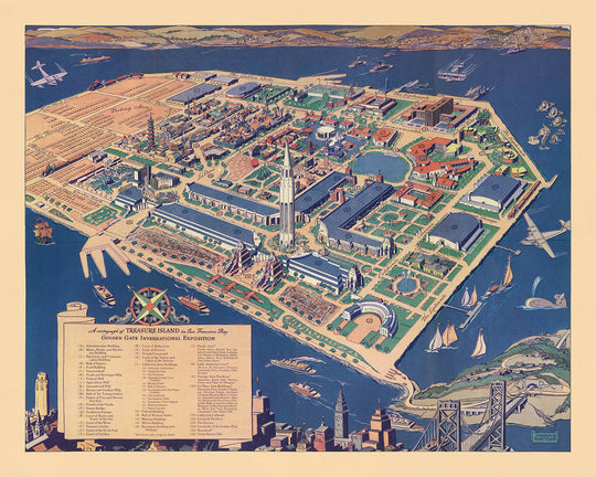
Step into the vibrant world of the late 1930s with this exquisite pictorial map, “A cartograph of Treasure Island in San Francisco Bay,” masterfully created by Ruth Taylor White in 1939. Commissioned for the Golden Gate International Exposition, this map is a rare and captivating artifact that captures the spirit of a pivotal moment in San Francisco’s history. With its sweeping bird’s-eye view, the map brings to life the newly constructed Treasure Island, a marvel of engineering and ambition, built specifically to host the world’s fair and to showcase the Bay Area’s innovation on a global stage.
Ruth Taylor White’s artistry shines through in every detail, blending whimsical illustrations with precise cartographic information. The waters surrounding Treasure Island teem with sea monsters, whales, boats, and airplanes, each element playfully rendered to evoke the excitement and optimism of the exposition. The map’s lively vignettes and vibrant color palette invite viewers to explore not just the physical space of the fairgrounds, but also the imaginative possibilities of the era. The inclusion of a legend and clearly marked exposition buildings further enhances its value, making it both a navigational tool and a work of art.
Historically, this map stands as a testament to the cultural and architectural achievements of the Golden Gate International Exposition. The exposition grounds, meticulously depicted, highlight significant landmarks such as the Tower of the Sun, the Court of the Seven Seas, and the California Building. These structures, many of which were temporary yet grand in scale, represented the aspirations of a city emerging from the Great Depression and looking toward a brighter, interconnected future. The map also features the iconic Bay Bridge, linking San Francisco to Treasure Island and symbolizing the city’s role as a gateway to the Pacific.
Beyond its immediate function as a guide for fairgoers, the map offers a fascinating glimpse into the urban landscape of San Francisco at the dawn of World War II. The city’s waterfront, bustling ferry terminals, and the meticulously planned exposition pavilions all reflect the dynamic interplay between tradition and modernity. The inclusion of recreational areas, gardens, and thematic illustrations underscores the fair’s international scope and its celebration of progress, culture, and community.
Collectors and historians alike will appreciate the map’s unique blend of artistic flair and documentary precision. As both a historical artifact and a piece of visual storytelling, it encapsulates the optimism, creativity, and cosmopolitan energy of San Francisco in 1939. Whether displayed as a centerpiece or studied for its rich detail, this map offers an immersive journey into a defining chapter of the city’s past, making it an exceptional addition to any collection of fine historical cartography.
Places on this map
- Treasure Island
- San Francisco (city)
- Golden Gate International Exposition grounds
- Bay Bridge (San Francisco-Oakland Bay Bridge)
- Administration Building (on Treasure Island)
- Hall of Transportation (on Treasure Island)
- Court of the Seven Seas (on Treasure Island)
- Tower of the Sun (on Treasure Island)
- California Building (on Treasure Island)
- Federal Building (on Treasure Island)
- Palace of Fine and Decorative Arts (on Treasure Island)
- Aviation Building (on Treasure Island)
- Main Entrance (to the exposition grounds)
- Ferry Terminal (on Treasure Island)
- Yacht Harbor (adjacent to Treasure Island)
- Gardens and recreational areas (on Treasure Island)
- San Francisco waterfront (Embarcadero area)
- Ferry routes between San Francisco and Treasure Island
- Airfield or aviation area (on Treasure Island)
- Exposition pavilions and exhibit halls (various, on Treasure Island)
Notable Features & Landmarks
- The exposition grounds, with clearly marked buildings and pavilions
- A legend identifying key exposition buildings and features
- San Francisco cityscape in the foreground, including recognizable landmarks
- Whimsical illustrations of sea monsters in the waters around Treasure Island
- Whales and other marine life depicted in the bay
- Boats and ships navigating the waters around the island
- Airplanes flying above the exposition, emphasizing the modernity of the event
- Bridges connecting San Francisco to the island (including the Bay Bridge)
- Decorative compass rose or orientation marker
- Artistic border with thematic motifs related to the exposition
- Pathways and roads clearly marked on Treasure Island
- Flags and banners indicating the festive nature of the event
- Notations or labels for significant exposition buildings
- Illustrations of crowds or visitors attending the fair
- Thematic illustrations reflecting the international scope of the exposition
- Colorful, stylized representations of water and land
- Explanatory text or callouts providing context for certain features
- Prominent display of the year "1939" and the exposition's title
Historical and design context
- Name of the map: A cartograph of Treasure Island in San Francisco Bay
- Mapmaker: Ruth Taylor White, a noted American pictorial cartographer known for her colorful, whimsical, and highly detailed maps
- Date of creation: 1939
- Publisher: Crocker Company, San Francisco
- Created for the Golden Gate International Exposition, a World's Fair held on Treasure Island in San Francisco Bay in 1939
- Birds-eye view pictorial map, richly illustrated with vibrant and whimsical elements
- Part of a guide book with an art-deco cover, reflecting the aesthetics of the late 1930s
- Includes a legend identifying various exposition buildings and features, enhancing its utility for visitors and historians
- Captures the grandeur and spirit of the 1939 Golden Gate International Exposition, a major cultural and architectural event in San Francisco’s history
- Highlights the exposition grounds, architectural features, recreational activities, and the festive atmosphere of the World's Fair
- Served both as a navigation tool for exposition attendees and as a historical artifact documenting the event
- Treasure Island was constructed specifically for the exposition, symbolizing innovation and progress in the Bay Area
- Reflects the optimism and enthusiasm of late 1930s America, particularly in the context of international expositions
- Ruth Taylor White was known for her ability to capture the essence of a place through both cartographic detail and artistic embellishment
- The map remains a valuable resource for historians, collectors, and those interested in the history of San Francisco and World's Fairs
Please double check the images to make sure that a specific town or place is shown on this map. You can also get in touch and ask us to check the map for you.
This map looks great at every size, but I always recommend going for a larger size if you have space. That way you can easily make out all of the details.
This map looks amazing at sizes all the way up to 70in (180cm). If you are looking for a larger map, please get in touch.
The model in the listing images is holding the 16x20in (40x50cm) version of this map.
The fifth listing image shows an example of my map personalisation service.
If you’re looking for something slightly different, check out my collection of the best old maps to see if something else catches your eye.
Please contact me to check if a certain location, landmark or feature is shown on this map.
This would make a wonderful birthday, Christmas, Father's Day, work leaving, anniversary or housewarming gift for someone from the areas covered by this map.
This map is available as a giclée print on acid free archival matte paper, or you can buy it framed. The frame is a nice, simple black frame that suits most aesthetics. Please get in touch if you'd like a different frame colour or material. My frames are glazed with super-clear museum-grade acrylic (perspex/acrylite), which is significantly less reflective than glass, safer, and will always arrive in perfect condition.
This map is also available as a float framed canvas, sometimes known as a shadow gap framed canvas or canvas floater. The map is printed on artist's cotton canvas and then stretched over a handmade box frame. We then "float" the canvas inside a wooden frame, which is available in a range of colours (black, dark brown, oak, antique gold and white). This is a wonderful way to present a map without glazing in front. See some examples of float framed canvas maps and explore the differences between my different finishes.
For something truly unique, this map is also available in "Unique 3D", our trademarked process that dramatically transforms the map so that it has a wonderful sense of depth. We combine the original map with detailed topography and elevation data, so that mountains and the terrain really "pop". For more info and examples of 3D maps, check my Unique 3D page.
Para la mayoría de los pedidos, el tiempo de entrega es de aproximadamente 3 días laborables. Los productos personalizados y a medida tardan más, ya que tengo que hacer la personalización y enviártelo para su aprobación, lo cual suele tardar 1 o 2 días.
Tenga en cuenta que los pedidos enmarcados muy grandes suelen tardar más en fabricarse y entregarse.
Si necesitas que tu pedido llegue para una fecha determinada, por favor contáctame antes de hacer el pedido para que podamos encontrar la mejor manera de asegurarnos de que recibas tu pedido a tiempo.
Imprimo y enmarco mapas y obras de arte en 23 países alrededor del mundo. Esto significa que tu pedido se fabricará localmente, lo que reduce el tiempo de entrega y asegura que no se dañe durante el envío. Nunca pagarás aranceles de aduana o impuestos de importación, y pondremos menos CO2 en el aire.
Todos mis mapas y impresiones artísticas están bien empaquetados y enviados en un tubo resistente si no están enmarcados, o rodeados de espuma si están enmarcados.
Intento enviar todos los pedidos dentro de 1 o 2 días después de recibir tu pedido, aunque algunos productos (como mascarillas, tazas y bolsas de tela) pueden tardar más en fabricarse.
Si seleccionas Entrega Exprés al finalizar la compra, priorizaremos tu pedido y lo enviaremos por mensajería de 1 día (Fedex, DHL, UPS, Parcelforce).
La entrega al día siguiente también está disponible en algunos países (EE. UU., Reino Unido, Singapur, EAU), pero por favor intenta hacer tu pedido temprano en el día para que podamos enviarlo a tiempo.
Mi marco estándar es un marco de madera de fresno negro estilo galería. Es simple y tiene un aspecto bastante moderno. Mi marco estándar tiene alrededor de 20 mm (0.8 in) de ancho.
Utilizo acrílico super claro (perspex/acrylite) para el vidrio del marco. Es más ligero y seguro que el vidrio, y se ve mejor, ya que la reflectividad es menor.
Seis colores de marco estándar están disponibles de forma gratuita (negro, marrón oscuro, gris oscuro, roble, blanco y oro antiguo).El enmarcado y montaje/matizado personalizado está disponible si buscas algo diferente.
La mayoría de los mapas, arte e ilustraciones también están disponibles como un lienzo enmarcado. Utilizamos lienzo de algodón mate (no brillante), lo estiramos sobre un marco de madera de caja de origen sostenible, y luego 'flotamos' la pieza dentro de un marco de madera. El resultado final es bastante hermoso, y no hay cristal que se interponga.
Todos los marcos se proporcionan "listos para colgar", con una cuerda o soportes en la parte posterior. Los marcos muy grandes tendrán placas de colgar de alta resistencia y/o un listón de montaje. Si tienes alguna pregunta, por favor ponte en contacto.
Mira algunos ejemplos de mis mapas enmarcados y mapas en lienzo enmarcados.
Alternativamente, también puedo proporcionar mapas antiguos y obras de arte en lienzo, tablero de espuma, papel de algodón y otros materiales.
Si deseas enmarcar tu mapa o obra de arte tú mismo, por favor lee mi guía de tamaños primero.
Algunos de mis mapas antiguos ahora están disponibles como lienzos enmarcados. Por favor contáctame si deseas pedir un tamaño que no está disponible en mi tienda.
Los mapas antiguos en lienzo son una alternativa interesante a los mapas enmarcados convencionalmente. Dependiendo de tu gusto personal y la decoración de la habitación, los mapas en lienzo pueden "destacar" un poco más que un mapa enmarcado.
Mis mapas son reproducciones de mapas originales de altísima calidad.
Obtengo mapas originales y raros de bibliotecas, casas de subastas y colecciones privadas de todo el mundo, los restauro en mi taller de Londres y luego uso tintas e impresoras giclée especializadas para crear hermosos mapas que lucen incluso mejor que el original.
Mis mapas están impresos en papel de archivo mate (no brillante) sin ácido que se siente de muy alta calidad y casi como una tarjeta. En términos técnicos, el peso/grosor del papel es de 10 mil/200 g/m². Es perfecto para enmarcar.
Imprimo con tintas pigmentadas Epson ultrachrome giclée UV resistentes a la decoloración, algunas de las mejores tintas que puedes encontrar.
yo también puedo hacer mapas sobre lienzo, trapo de algodón y otros materiales exóticos.
Obtenga más información sobre The Unique Maps Co..
Personalización de mapas
Si está buscando el regalo perfecto de aniversario o inauguración de la casa, puedo personalizar su mapa para hacerlo verdaderamente único. Por ejemplo, puedo agregar un mensaje corto, resaltar una ubicación importante o agregar el escudo de armas de su familia.
Las opciones son casi infinitas. Por favor mira mi página de personalización de mapas para ver algunos maravillosos ejemplos de lo que es posible.
Para pedir un mapa personalizado, seleccione "personalizar su mapa" antes de agregarlo a su carrito.
Ponerse en contacto si buscas personalizaciones y personalizaciones más complejas.
Envejecimiento del mapa
A lo largo de los años, los clientes me han preguntado cientos de veces si podían comprar un mapa que se viera uniforme. más viejo.
Bueno, ahora puedes hacerlo seleccionando Envejecido antes de agregar un mapa a tu carrito.
Todas las fotografías de productos que ve en esta página muestran el mapa en su forma original. Así es como se ve el mapa hoy.
Si selecciona Envejecido, envejeceré su mapa a mano, usando un proceso especial y único desarrollado a través de años de estudiar mapas antiguos, hablar con investigadores para comprender la química del envejecimiento del papel y, por supuesto... ¡mucha práctica!
Si no estás seguro, quédate con el color original del mapa. Si quieres algo un poco más oscuro y más viejo buscando, opte por Envejecido.
Si no estás satisfecho con tu pedido por cualquier motivo, contáctame para un reembolso sin complicaciones. Por favor, consulta nuestra política de devoluciones y reembolsos para más información.
Estoy muy seguro de que te gustará tu mapa o impresión artística restaurada. He estado haciendo esto desde 1984. Soy un vendedor de 5 estrellas en Etsy. He vendido decenas de miles de mapas e impresiones artísticas y tengo más de 5,000 opiniones reales de 5 estrellas.
Utilizo un proceso único para restaurar mapas y obras de arte que consume mucho tiempo y mano de obra. Buscar los mapas e ilustraciones originales puede llevar meses. Utilizo tecnología de última generación y extremadamente cara para escanear y restaurarlos. Como resultado, garantizo que mis mapas e impresiones artísticas son superiores a los demás - por eso puedo ofrecer un reembolso sin complicaciones.
Casi todos mis mapas e impresiones artísticas se ven increíbles en tamaños grandes (200cm, 6.5ft+) y también puedo enmarcarlos y entregártelos a través de un servicio de mensajería especial para tamaños grandes. Contáctame para discutir tus necesidades específicas.
Or try searching for something!


