


Vecchia mappa del New Mexico e dello Utah di J.H. Colton, 1856: Santa Fe, Albuquerque, Provo, Salt Lake City, St. George
20% di sconto su 2 — 33% di sconto su 3
Aggiungi qualsiasi due articoli idonei al tuo carrello per ricevere 20% di sconto. Aggiungi un terzo e sarà gratuito (equivalente a 33% di sconto quando acquisti tre).
Nessun codice necessario — l'offerta si applica automaticamente al checkout.
Valido su tutte le mappe standard e le stampe d'arte fine. Puoi mescolare e abbinare qualsiasi design.
Se desideri spedire articoli a più indirizzi, ti preghiamo di contattarci prima di effettuare il tuo ordine.
Le commissioni personalizzate e su misura sono escluse.
Contattaci se hai domande
 Progettato a Londra Prodotto in the USA
Progettato a Londra • Prodotto in the USA
Progettato a Londra Prodotto in the USA
Progettato a Londra • Prodotto in the USA

Choose your size
Choose your finish


(Maggiori informazioni)
Gift message & custom finish

If you want to add a gift message, or a finish (jigsaw, aluminium board, etc.) that is not available here, please request it in the "order note" when you check out.
Every order is custom made, so if you need the size adjusted slightly, or printed on an unusual material, just let us know. We've done thousands of custom orders over the years, so there's (almost) nothing we can't manage.
You can also contact us before you order, if you prefer!

- Made locally for fast, safe delivery
- No import duty or hidden fees
- Need advice? Message us on WhatsApp
Own a piece of history
7,000+ 5 star reviews


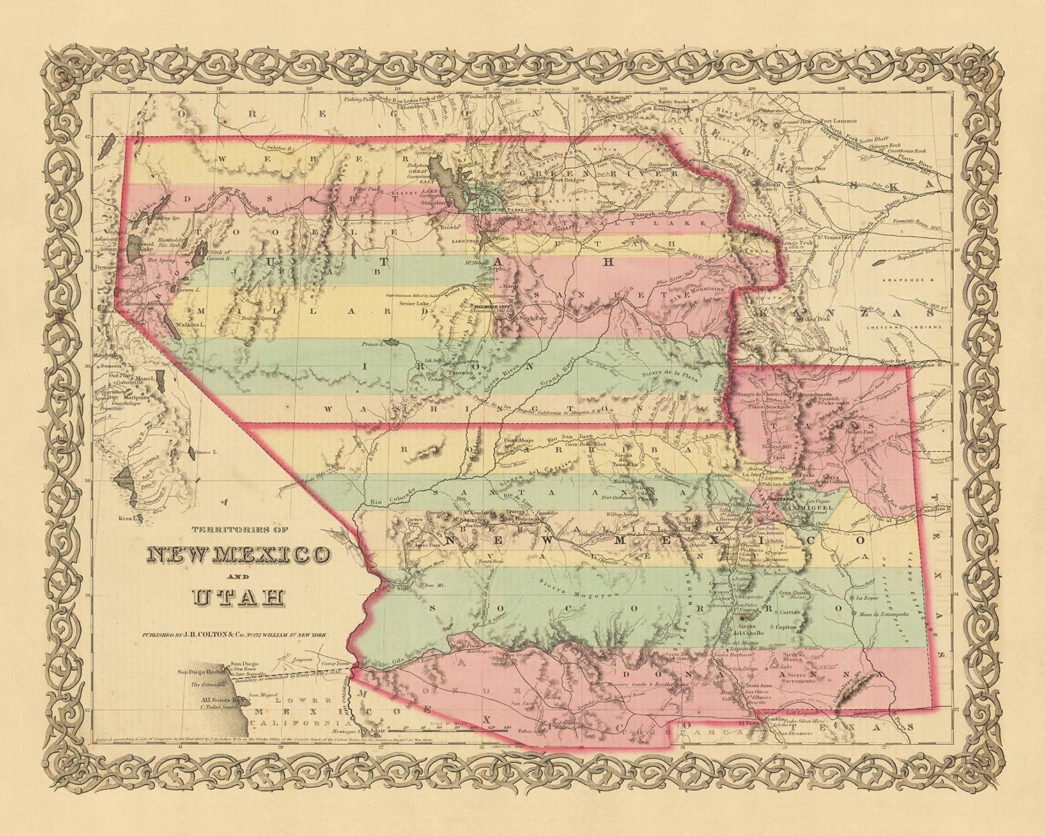
Viaggia indietro nel tempo con questa squisita mappa antica del New Mexico e dello Utah, meticolosamente realizzata da J.H. Colton nel 1856. Colton, ampiamente considerato il principale cartografo americano della sua epoca, porta in vita la ricca storia di queste regioni in dettagli straordinari. Questa mappa funge da istantanea di un momento cruciale nella storia iniziale degli Stati Uniti, un periodo in cui molti degli insediamenti che conosciamo oggi dovevano ancora essere fondati e i nomi e i confini dei territori erano in uno stato di flusso.
Questa mappa offre una prospettiva unica sull'evoluzione del West americano. Nel 1856, il New Mexico e lo Utah erano territori di frontiera, i loro paesaggi in gran parte inesplorati e le loro popolazioni scarse. La mappa rivela un mondo in cui il familiare si mescola con l'ignoto, dove città e paesi che ora sono nomi noti coesistono con insediamenti che da allora sono svaniti nell'oscurità. È uno sguardo affascinante nel passato, una testimonianza dell'irresistibile fascino di queste terre storiche.
La mappa presenta cinque degli insediamenti più notevoli del New Mexico e dello Utah nel 1855: Santa Fe, Albuquerque, Provo, Salt Lake City e St. George. Questi insediamenti, alcuni dei quali sono cresciuti in città vivaci, servono come indicatori dell'impronta umana su questi vasti territori. Ognuno ha la propria storia da raccontare, il proprio posto nel ricco arazzo della storia americana.
A Santa Fe, la capitale più antica degli Stati Uniti, si possono rintracciare gli echi del dominio coloniale spagnolo. Albuquerque, con il suo mix di culture nativo americane, ispaniche e anglo, è una testimonianza del patrimonio diversificato della regione. Provo, incastonata tra l'impressionante catena montuosa Wasatch e il lago Utah, era un insediamento mormone in espansione. Salt Lake City, il cuore del movimento pionieristico mormone, era un faro di speranza e un simbolo di resilienza. E St. George, con le sue impressionanti scogliere rosse, era un avamposto di frontiera al confine del deserto del Mojave.
Questa mappa di J.H. Colton è più di una semplice rappresentazione geografica del New Mexico e dello Utah nel 1856. È un pezzo di storia, una finestra su un'epoca passata e una testimonianza dello spirito duraturo di esplorazione e scoperta. È un promemoria di quanto siamo progrediti come nazione e un tributo ai pionieri che hanno tracciato il corso della nostra storia condivisa. Questo è un pezzo eccezionale per qualsiasi collezionista esigente, un vero gioiello che aggiungerà un tocco di eleganza e intrigo storico a qualsiasi ambiente.
New Mexico
- Santa Fe (1610) - Conosciuta come "La Villa Real de la Santa Fe de San Francisco," è la capitale statale più antica degli Stati Uniti.
- Albuquerque (1706) - Originariamente chiamata "La Villa de Alburquerque," è nota per il suo mix culturale di influenze nativo americane, ispaniche e anglo.
- Las Cruces (1849) - Fondata durante la corsa all'oro in California, era una tappa fondamentale sulla rotta della posta Butterfield Overland.
- Socorro (1598) - Originariamente chiamata "Nuestra Señora de Perpetuo Socorro," era un insediamento chiave nell'era coloniale spagnola.
- Taos (1615) - Nota per il storico Taos Pueblo, un sito patrimonio dell'umanità dell'UNESCO.
- Bernalillo (1695) - Casa del sito storico di Coronado, dove sono stati trovati i resti di un antico pueblo indiano.
- Los Lunas (1716) - Prende il nome dalla famiglia Luna, primi coloni spagnoli nella regione.
- Las Vegas (1835) - Non deve essere confusa con l'omonima in Nevada, era una tappa fondamentale sulla Santa Fe Trail.
- Mesilla (1848) - Conosciuta per l'historic Mesilla Plaza, un sito chiave nella guerra messicano-americana.
- Cimarron (1850) - Una fermata significativa sul Santa Fe Trail e successivamente un hub per l'industria mineraria.
Utah
- Salt Lake City (1847) - Fondata dai pionieri mormoni e serve come quartier generale della Chiesa di Gesù Cristo dei Santi degli Ultimi Giorni.
- Provo (1849) - Sede della Brigham Young University, una delle più grandi istituzioni di istruzione superiore privata negli Stati Uniti.
- Ogden (1846) - Un importante hub ferroviario, conosciuto come "Junction City."
- Farmington (1847) - Originariamente colonizzata dai pionieri mormoni, è la sede della contea di Davis.
- Bountiful (1847) - Prende il nome da una città nel Libro di Mormon, è stata colonizzata da Perrigrine Sessions, un noto pioniere mormone.
- Manti (1849) - Conosciuta per il Tempio di Manti Utah, il terzo tempio costruito dalla Chiesa mormone.
- Parowan (1851) - Conosciuta come la "Città Madre del Sud Utah," molte città del sud Utah sono state colonizzate da Parowan.
- Springville (1850) - Prende il nome per le numerose sorgenti d'acqua dolce nella zona, è sede del Museo d'Arte di Springville.
- Fillmore (1851) - Prende il nome dal presidente Millard Fillmore, è stata un tempo la capitale del Territorio dello Utah.
- Cedar City (1851) - Conosciuta come "Porta dei Parchi Nazionali" a causa della sua vicinanza a diverse attrazioni naturali.
Tribù e Territori Indiani
- Navajo Nation - La più grande area di terra assegnata principalmente a una giurisdizione nativa americana.
- Ute Indian Tribe - La riserva Uintah e Ouray della tribù si trova nel nord-est dello Utah.
- Pueblo Tribes - Conosciute per la loro architettura e artigianato unici.
- Apache Tribes - Storicamente conosciute per le loro forti tradizioni guerriere.
Fenomeni Naturali Notabili
- Rio Grande - Uno dei principali fiumi nel sud-ovest degli Stati Uniti e nel nord del Messico.
- Great Salt Lake - Il lago salato più grande dell'emisfero occidentale.
- Zion National Park - Nota per le sue scogliere di arenaria e la fauna selvatica unica.
- Bryce Canyon - Conosciuta per le sue strutture geologiche distintive, chiamate hoodoos.
- White Sands National Park - Il più grande campo di dune di gesso del mondo.
Eventi Storici
- Mexican-American War (1846-1848) - Ha portato gli Stati Uniti ad acquisire una grande parte dell'attuale sud-ovest americano, inclusi New Mexico e Utah.
- Mormon Pioneer Exodus (1846-1857) - La migrazione dei membri della Chiesa di Gesù Cristo dei Santi degli Ultimi Giorni nella valle di Salt Lake.
- Compromise of 1850 - Ha ammesso la California come stato libero e ha stabilito Utah e New Mexico come territori con la questione della schiavitù da decidere tramite sovranità popolare.
Si prega di controllare attentamente le immagini per assicurarsi che una specifica città o luogo sia mostrato su questa mappa. È possibile anche contattarci e chiedere di controllare la mappa per voi.
Questa mappa appare fantastica in tutte le dimensioni: 12x16in (30.5x41cm), 16x20in (40.5x51cm), 18x24in (45.5x61cm), 24x30in (61x76cm), 32x40in (81.5x102cm), 40x50in (102x127cm), 48x60in (122x153cm) e 56x70in (142x178cm), ma appare ancora meglio se stampata in grande.
Posso creare bellissime stampe di grandi dimensioni di questa mappa fino a 70in (178cm). Ti prego di contattarmi se stai cercando opzioni di incorniciatura più grandi, personalizzate o diverse.
Il modello nelle immagini dell'inserzione tiene la versione 16x20in (40.5x51cm) di questa mappa.
La quinta immagine dell'inserzione mostra un esempio del mio servizio di personalizzazione della mappa.
Se stai cercando qualcosa di leggermente diverso, dai un'occhiata alla mia principale collezione di mappe degli USA e del Nord America.
Per favore contattami per verificare se una certa posizione, un punto di riferimento o una caratteristica è mostrata su questa mappa.
Questo sarebbe un meraviglioso regalo di compleanno, Natale, Festa del Papà, addio al lavoro, anniversario o per una festa di inaugurazione per qualcuno delle aree coperte da questa mappa.
Questa mappa è disponibile come stampa giclée su carta opaca archiviata priva di acidi, oppure puoi acquistarla incorniciata. La cornice è una semplice cornice nera che si adatta alla maggior parte degli stili. Ti prego di contattarmi se desideri un colore o un materiale di cornice diverso. Le mie cornici sono vetriate con acrilico di grado museo super chiaro (perspex/acrylite), che è significativamente meno riflettente del vetro, più sicuro e arriverà sempre in perfette condizioni.
This map is also available as a float framed canvas, sometimes known as a shadow gap framed canvas or canvas floater. The map is printed on artist's cotton canvas and then stretched over a handmade box frame. We then "float" the canvas inside a wooden frame, which is available in a range of colours (black, dark brown, oak, antique gold and white). This is a wonderful way to present a map without glazing in front. See some examples of float framed canvas maps and explore the differences between my different finishes.
For something truly unique, this map is also available in "Unique 3D", our trademarked process that dramatically transforms the map so that it has a wonderful sense of depth. We combine the original map with detailed topography and elevation data, so that mountains and the terrain really "pop". For more info and examples of 3D maps, check my Unique 3D page.
Many of our maps and art prints are chosen as thoughtful gifts for homes, offices, studies and meaningful places.
Choose a framed option for the easiest ready-to-hang gift, or choose an unframed print if the recipient may prefer to select their own frame.
We make orders locally in 23 countries around the world, so gifts can often be produced close to the recipient. This helps them arrive faster, travel more safely, and avoid customs or import duty surprises.
- We can deliver directly to the recipient
- Framed pieces arrive ready to hang
- Unframed prints are carefully packed in a strong protective tube
- Almost every order is made locally, for faster, safer gifting
- 90-day returns give the recipient time to decide
If you are not sure what to choose, please contact us. We can help you pick the right map, size, finish or delivery option.
Most orders are made locally and delivered in around 2–3 working days, depending on the product, size and destination.
We print and frame maps and artwork in 23 countries around the world, so your order is usually made close to you or your recipient. That means faster delivery, less time in transit, and no customs or import duty surprises.
Personalised and customised pieces usually take an extra 1–2 working days, because we prepare your design and send it to you for approval before printing.
Very large framed orders can take a little longer, as they need extra care in production and delivery.
Every order is carefully packaged: unframed prints are sent in a strong protective tube, while framed pieces are securely packed with protective materials around the frame.
If you need your order by a particular date, please contact us before ordering. We’ll check the best production route and delivery option for your location.
Express delivery is available at checkout for most countries. Next-day delivery is available in the UK, US, Singapore and the UAE.
Your order is covered by our 90-day returns policy and 10-year guarantee.
Our standard frame is a gallery-style black ash hardwood frame, with a simple, modern look. It is approximately 20mm (0.8in) wide. You can also view some lovely customer photos of framed maps and art.
We use super-clear acrylic glazing, also known as Perspex or Acrylite, instead of traditional glass. It is lighter, safer, and has lower reflectivity, giving the artwork a clearer, cleaner appearance.
Six standard frame colours are available at no extra cost: black, dark brown, dark grey, oak, white, and antique gold. Custom framing and mounting/matting is also available for customers looking for something more specific.
Most maps, art prints, and illustrations are also available as a framed canvas. We use matte cotton canvas, stretch it over a sustainably sourced wooden box frame, and then float the piece within a wooden outer frame. The finished result is beautifully presented, with no glazing between you and the artwork.
All frames are supplied ready to hang, with either string or brackets fitted to the back. Very large frames will include heavy-duty hanging plates and/or a mounting baton. If you have any questions, please get in touch.
We can also supply old maps and artwork on canvas, foam board, cotton rag, and other materials.
If you would prefer to frame your map or artwork yourself, please read our size guide before ordering.
My maps are extremely high quality reproductions of original maps.
I source original, rare maps from libraries, auction houses and private collections around the world, restore them at my London workshop, and then use specialist giclée inks and printers to create beautiful maps that look even better than the original.
My maps are printed on acid-free archival matte (not glossy) paper that feels very high quality and almost like card. In technical terms the paper weight/thickness is 10mil/200gsm. It's perfect for framing.
I print with Epson ultrachrome giclée UV fade resistant pigment inks - some of the best inks you can find.
I can also make maps on canvas, cotton rag and other exotic materials.
Learn more about The Unique Maps Co.
Map personalisation
If you're looking for the perfect anniversary or housewarming gift, I can personalise your map to make it truly unique. For example, I can add a short message, or highlight an important location, or add your family's coat of arms.
The options are almost infinite. Please see my map personalisation page for some wonderful examples of what's possible.
To order a personalised map, select "personalise your map" before adding it to your basket.
Get in touch if you're looking for more complex customisations and personalisations.
Map ageing
I have been asked hundreds of times over the years by customers if they could buy a map that looks even older.
Well, now you can, by selecting Aged before you add a map to your basket.
All the product photos you see on this page show the map in its Original form. This is what the map looks like today.
If you select Aged, I will age your map by hand, using a special and unique process developed through years of studying old maps, talking to researchers to understand the chemistry of aging paper, and of course... lots of practice!
If you're unsure, stick to the Original colour of the map. If you want something a bit darker and older looking, go for Aged.
Se non sei soddisfatto del tuo ordine per qualsiasi motivo, contattami per un rimborso senza problemi. Si prega di consultare la nostra politica di reso e rimborso per ulteriori informazioni.
Sono molto sicuro che ti piacerà la tua mappa restaurata o la stampa d'arte. Lo faccio dal 1984. Sono un venditore Etsy a 5 stelle. Ho venduto decine di migliaia di mappe e stampe d'arte e ho oltre 5.000 recensioni reali a 5 stelle.
Utilizzo un processo unico per restaurare mappe e opere d'arte che richiede molto tempo e lavoro. Trovare le mappe e le illustrazioni originali può richiedere mesi. Utilizzo tecnologia all'avanguardia e incredibilmente costosa per scannerizzare e restaurarle. Di conseguenza, garantisco che le mie mappe e stampe d'arte siano superiori alle altre - ecco perché posso offrire un rimborso senza problemi.
Quasi tutte le mie mappe e stampe d'arte sembrano fantastiche a grandi dimensioni (200 cm, 6,5 piedi+) e posso anche incorniciarle e consegnarle a te, tramite un corriere speciale per oggetti di grandi dimensioni. Contattami per discutere delle tue esigenze specifiche.
Or try searching for something!


