


Antica mappa di Milano di Pinchetti, 1801: Foro Bonaparte, Cittadella, Canale Naviglio, Piazze
20% di sconto su 2 — 33% di sconto su 3
Aggiungi qualsiasi due articoli idonei al tuo carrello per ricevere 20% di sconto. Aggiungi un terzo e sarà gratuito (equivalente a 33% di sconto quando acquisti tre).
Nessun codice necessario — l'offerta si applica automaticamente al checkout.
Valido su tutte le mappe standard e le stampe d'arte fine. Puoi mescolare e abbinare qualsiasi design.
Se desideri spedire articoli a più indirizzi, ti preghiamo di contattarci prima di effettuare il tuo ordine.
Le commissioni personalizzate e su misura sono escluse.
Contattaci se hai domande
 Progettato a Londra Prodotto in the USA
Progettato a Londra • Prodotto in the USA
Progettato a Londra Prodotto in the USA
Progettato a Londra • Prodotto in the USA

Restaurata dalla mappa originale del 1801 e stampata in qualità museale. Leggi la storia dietro questa mappa
Choose your size
Choose your finish


(Maggiori informazioni)
Gift message & custom finish

If you want to add a gift message, or a finish (jigsaw, aluminium board, etc.) that is not available here, please request it in the "order note" when you check out.
Every order is custom made, so if you need the size adjusted slightly, or printed on an unusual material, just let us know. We've done thousands of custom orders over the years, so there's (almost) nothing we can't manage.
You can also contact us before you order, if you prefer!

- Prodotto localmente. Consegna sicura
- Nessun dazio o costo nascosto
- Serve aiuto? Chiamaci o messaggio su WhatsApp
Own a piece of history
8,000+ five-star reviews


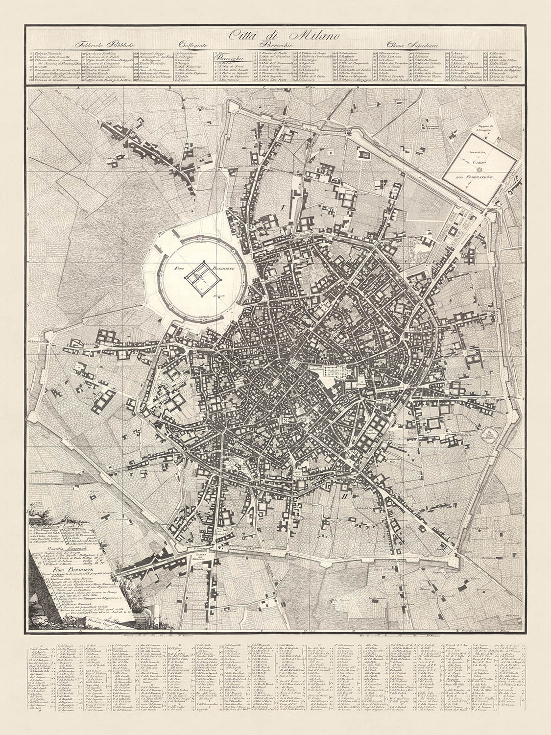
La mappa della "Città di Milano", meticolosamente realizzata da Giacomo Pinchetti nel 1801 e incisa da Giuseppe Caniani, è un notevole testamento...
Continua a leggereLa mappa della "Città di Milano", meticolosamente realizzata da Giacomo Pinchetti nel 1801 e incisa da Giuseppe Caniani, è un notevole testamento della grandezza urbana e architettonica della Milano dei primi del XIX secolo. Questa squisita mappa non solo traccia il complesso layout delle strade e delle piazze di Milano, ma incapsula anche la visione ambiziosa dell'era napoleonica, in particolare attraverso il progetto del Foro Bonaparte proposto. Questo progetto, sebbene mai realizzato, prevedeva uno spazio urbano trasformativo con un edificio civile quasi quadrato al suo centro, circondato da edifici pubblici e privati, riflettendo la grandiosità della pianificazione urbana napoleonica.
Uno degli aspetti più affascinanti di questa mappa è la sua dettagliata rappresentazione dei quartieri e dei luoghi significativi di Milano. La Cittadella di Milano, un punto focale del progetto del Foro Bonaparte, è presentata in modo prominente, illustrando la trasformazione prevista di questa fortezza militare in un centro civico. La mappa evidenzia anche il Canale Naviglio, progettato per attraversare la città, migliorando sia il suo appeal estetico che la connettività funzionale. Questo canale era pianificato per uscire dall'area doganale, correre parallelo a un portico continuo e connettersi alla nuova strada per la Francia tramite Sempione, mostrando l'integrazione del design urbano e dei trasporti.
Oltre ai suoi elementi architettonici e infrastrutturali, la mappa fornisce un elenco completo delle fabbriche pubbliche di Milano, delle chiese collegiali, delle parrocchie e delle chiese sussidiarie. Questi sono catalogati meticolosamente in dodici colonne nella parte superiore, offrendo un dettagliato spaccato del paesaggio religioso e industriale della città. L'angolo in basso a sinistra della mappa arricchisce ulteriormente questo arazzo storico dettagliando i luoghi di istruzione, i luoghi pii e la Guardia Nazionale, sottolineando la natura multifaccettata della società milanese dell'epoca.
Il design della mappa è una lezione di eleganza cartografica, con scale grafiche in Braccia Milanesi e Tese di Francia, fornendo misurazioni precise per riferimento contemporaneo e futuro. Le diciotto colonne in fondo, che elencano i nomi delle strade, delle piazze e delle porte, servono come una preziosa directory, guidando l'osservatore attraverso le strade labirintiche di Milano. Questa dettagliata enumerazione non solo aiuta la navigazione, ma offre anche intuizioni sul tessuto urbano e sulla nomenclatura del periodo.
Storicamente, la mappa della "Città di Milano" è significativa per la sua rappresentazione di una visione urbana ambiziosa che, nonostante la sua non realizzazione, riflette le aspirazioni e il dinamismo della Milano napoleonica. Essa rappresenta un documento prezioso per storici, urbanisti e appassionati di cartografia, offrendo una finestra sul passato della città e sui grandi progetti che hanno plasmato il suo sviluppo. Questa mappa non è solo una rappresentazione delle strade e degli edifici di Milano; è una narrazione dei sogni di una città e delle forze storiche che hanno influenzato la sua evoluzione.
Strade e vie in questa mappa
- Corso di Porta Romana
- Corso di Porta Ticinese
- Corso di Porta Venezia
- Corso di Porta Vercellina
- Piazza del Duomo
- Piazza San Babila
- Piazza Santo Stefano
- Piazza dei Mercanti
- Piazza della Scala
- Piazza del Carmine
- Piazza di Santa Maria
- Piazza di Sant'Ambrogio
- Piazza di San Fedele
- Piazza del Castello
- Piazza Beccaria
- Piazza Fontana
- Piazza Cavour
- Piazza Sant'Alessandro
- Piazza San Sepolcro
- Piazza San Nazaro in Brolo
- Piazza San Marco
- Piazza San Simpliciano
- Piazza San Giovanni in Conca
- Piazza San Carlo
- Piazza San Lorenzo
- Piazza San Maurilio
- Piazza Santa Maria alla Porta
- Piazza San Bernardino alle Ossa
- Piazza San Francesco di Paola
- Piazza San Vittore al Corpo
Caratteristiche e monumenti notevoli
- Illustrazioni:
- Incisioni dettagliate di edifici e layout della città.
- Monumenti:
- Foro Bonaparte (area del progetto).
- Citadella di Milano.
- Quartieri:
- Vari distretti della città sono dettagliati.
- Grandi parchi:
- L'area attorno alla Citadella sembra essere pianificata come spazio aperto nel progetto del Foro Bonaparte.
Contesto storico e di design
- Nome della mappa: Città di Milano
- Data di creazione: 1801
- Cartografo/Editore: Giacomo Pinchetti, inciso da Giuseppe Caniani
- Fabbriche pubbliche, Chiese collegiali, Parrocchie e Chiese sussidiarie: Elencate in dodici colonne in alto.
- Nomi di strade, piazze e porte: Inclusi in diciotto colonne in basso.
- Luoghi di istruzione, Luoghi pii, Riferimenti alla Guardia Nazionale e al Foro Bonaparte: Dettagliati nell'angolo in basso a sinistra con riferimenti secondo il progetto Antolini.
- Scale grafiche: Braccia Milanesi e Tese di Francia.
- Progetto del Foro Bonaparte di Antolini: Un significativo progetto dell'era napoleonica proposto per trasformare la Citadella di Milano con vari edifici pubblici e privati, portici e un Naviglio Canal ridisegnato. Nonostante l'inizio simbolico nel 1801, il progetto non è mai stato avviato.
- Pianificazione urbana e architettura: Sottolinea il progetto del Foro Bonaparte.
- Istituzioni religiose e pubbliche: Elenchi dettagliati di chiese e fabbriche pubbliche.
- Istruzione e pietà: Luoghi di istruzione e luoghi pii sono notati.
- Paesi e regioni mostrati: La mappa si concentra sulla città di Milano, Italia.
- Design e stile:
- Layout dettagliato di strade ed edifici.
- Ampio uso di elenchi e colonne per categorizzare le informazioni.
- Elementi cartografici classici con scale in unità locali.
- Importanza storica:
- Fornisce un'idea della pianificazione urbana milanese dei primi anni del 1800.
- Riflette l'influenza napoleonica sullo sviluppo della città.
- Documenta un ambizioso ma non realizzato progetto di trasformazione urbana.
Si prega di controllare attentamente le immagini per assicurarsi che una specifica città o luogo sia mostrato su questa mappa. Puoi anche contattarci e chiedere di controllare la mappa per te.
Questa mappa sembra fantastica in ogni dimensione, ma consiglio sempre di optare per una dimensione più grande se hai spazio. In questo modo puoi facilmente distinguere tutti i dettagli.
Questa mappa appare straordinaria in dimensioni fino a 100in (250cm). Se stai cercando una mappa più grande, per favore contattami.
Si prega di notare: le etichette su questa mappa sono difficili da leggere se ordini una mappa che è 20in (50cm) o più piccola. La mappa è comunque molto attraente, ma se desideri leggere la mappa facilmente, ti preghiamo di acquistare una dimensione più grande.
Il modello nelle immagini dell'inserzione sta tenendo la versione 18x24in (45x60cm) di questa mappa.
La quinta immagine dell'inserzione mostra un esempio del mio servizio di personalizzazione della mappa.
Se stai cercando qualcosa di leggermente diverso, dai un'occhiata alla mia collezione delle migliori vecchie mappe per vedere se qualcosa colpisce la tua attenzione.
Per favore contattami per verificare se una certa posizione, punto di riferimento o caratteristica è mostrata su questa mappa.
Questo sarebbe un meraviglioso regalo per un compleanno, Natale, Festa del Papà, pensionamento, anniversario o inaugurazione della casa per qualcuno delle aree coperte da questa mappa.
Questa mappa è disponibile come stampa giclée su carta opaca archiviata senza acidi, oppure puoi acquistarla incorniciata. La cornice è una bella e semplice cornice nera che si adatta alla maggior parte degli stili. Per favore, contattami se desideri un colore o un materiale della cornice diverso. Le mie cornici sono rivestite con acrilico super chiaro di grado museale (perspex/acrylite), che è significativamente meno riflettente del vetro, più sicuro e arriverà sempre in condizioni perfette.
This map is also available as a float framed canvas, sometimes known as a shadow gap framed canvas or canvas floater. The map is printed on artist's cotton canvas and then stretched over a handmade box frame. We then "float" the canvas inside a wooden frame, which is available in a range of colours (black, dark brown, oak, antique gold and white). This is a wonderful way to present a map without glazing in front. See some examples of float framed canvas maps and explore the differences between my different finishes.
For something truly unique, this map is also available in "Unique 3D", our trademarked process that dramatically transforms the map so that it has a wonderful sense of depth. We combine the original map with detailed topography and elevation data, so that mountains and the terrain really "pop". For more info and examples of 3D maps, check my Unique 3D page.
La mappa della "Città di Milano", meticolosamente realizzata da Giacomo Pinchetti nel 1801 e incisa da Giuseppe Caniani, è un notevole testamento della grandezza urbana e architettonica della Milano dei primi del XIX secolo. Questa squisita mappa non solo traccia il complesso layout delle strade e delle piazze di Milano, ma incapsula anche la visione ambiziosa dell'era napoleonica, in particolare attraverso il progetto del Foro Bonaparte proposto. Questo progetto, sebbene mai realizzato, prevedeva uno spazio urbano trasformativo con un edificio civile quasi quadrato al suo centro, circondato da edifici pubblici e privati, riflettendo la grandiosità della pianificazione urbana napoleonica.
Uno degli aspetti più affascinanti di questa mappa è la sua dettagliata rappresentazione dei quartieri e dei luoghi significativi di Milano. La Cittadella di Milano, un punto focale del progetto del Foro Bonaparte, è presentata in modo prominente, illustrando la trasformazione prevista di questa fortezza militare in un centro civico. La mappa evidenzia anche il Canale Naviglio, progettato per attraversare la città, migliorando sia il suo appeal estetico che la connettività funzionale. Questo canale era pianificato per uscire dall'area doganale, correre parallelo a un portico continuo e connettersi alla nuova strada per la Francia tramite Sempione, mostrando l'integrazione del design urbano e dei trasporti.
Oltre ai suoi elementi architettonici e infrastrutturali, la mappa fornisce un elenco completo delle fabbriche pubbliche di Milano, delle chiese collegiali, delle parrocchie e delle chiese sussidiarie. Questi sono catalogati meticolosamente in dodici colonne nella parte superiore, offrendo un dettagliato spaccato del paesaggio religioso e industriale della città. L'angolo in basso a sinistra della mappa arricchisce ulteriormente questo arazzo storico dettagliando i luoghi di istruzione, i luoghi pii e la Guardia Nazionale, sottolineando la natura multifaccettata della società milanese dell'epoca.
Il design della mappa è una lezione di eleganza cartografica, con scale grafiche in Braccia Milanesi e Tese di Francia, fornendo misurazioni precise per riferimento contemporaneo e futuro. Le diciotto colonne in fondo, che elencano i nomi delle strade, delle piazze e delle porte, servono come una preziosa directory, guidando l'osservatore attraverso le strade labirintiche di Milano. Questa dettagliata enumerazione non solo aiuta la navigazione, ma offre anche intuizioni sul tessuto urbano e sulla nomenclatura del periodo.
Storicamente, la mappa della "Città di Milano" è significativa per la sua rappresentazione di una visione urbana ambiziosa che, nonostante la sua non realizzazione, riflette le aspirazioni e il dinamismo della Milano napoleonica. Essa rappresenta un documento prezioso per storici, urbanisti e appassionati di cartografia, offrendo una finestra sul passato della città e sui grandi progetti che hanno plasmato il suo sviluppo. Questa mappa non è solo una rappresentazione delle strade e degli edifici di Milano; è una narrazione dei sogni di una città e delle forze storiche che hanno influenzato la sua evoluzione.
Strade e vie in questa mappa
- Corso di Porta Romana
- Corso di Porta Ticinese
- Corso di Porta Venezia
- Corso di Porta Vercellina
- Piazza del Duomo
- Piazza San Babila
- Piazza Santo Stefano
- Piazza dei Mercanti
- Piazza della Scala
- Piazza del Carmine
- Piazza di Santa Maria
- Piazza di Sant'Ambrogio
- Piazza di San Fedele
- Piazza del Castello
- Piazza Beccaria
- Piazza Fontana
- Piazza Cavour
- Piazza Sant'Alessandro
- Piazza San Sepolcro
- Piazza San Nazaro in Brolo
- Piazza San Marco
- Piazza San Simpliciano
- Piazza San Giovanni in Conca
- Piazza San Carlo
- Piazza San Lorenzo
- Piazza San Maurilio
- Piazza Santa Maria alla Porta
- Piazza San Bernardino alle Ossa
- Piazza San Francesco di Paola
- Piazza San Vittore al Corpo
Caratteristiche e monumenti notevoli
- Illustrazioni:
- Incisioni dettagliate di edifici e layout della città.
- Monumenti:
- Foro Bonaparte (area del progetto).
- Citadella di Milano.
- Quartieri:
- Vari distretti della città sono dettagliati.
- Grandi parchi:
- L'area attorno alla Citadella sembra essere pianificata come spazio aperto nel progetto del Foro Bonaparte.
Contesto storico e di design
- Nome della mappa: Città di Milano
- Data di creazione: 1801
- Cartografo/Editore: Giacomo Pinchetti, inciso da Giuseppe Caniani
- Fabbriche pubbliche, Chiese collegiali, Parrocchie e Chiese sussidiarie: Elencate in dodici colonne in alto.
- Nomi di strade, piazze e porte: Inclusi in diciotto colonne in basso.
- Luoghi di istruzione, Luoghi pii, Riferimenti alla Guardia Nazionale e al Foro Bonaparte: Dettagliati nell'angolo in basso a sinistra con riferimenti secondo il progetto Antolini.
- Scale grafiche: Braccia Milanesi e Tese di Francia.
- Progetto del Foro Bonaparte di Antolini: Un significativo progetto dell'era napoleonica proposto per trasformare la Citadella di Milano con vari edifici pubblici e privati, portici e un Naviglio Canal ridisegnato. Nonostante l'inizio simbolico nel 1801, il progetto non è mai stato avviato.
- Pianificazione urbana e architettura: Sottolinea il progetto del Foro Bonaparte.
- Istituzioni religiose e pubbliche: Elenchi dettagliati di chiese e fabbriche pubbliche.
- Istruzione e pietà: Luoghi di istruzione e luoghi pii sono notati.
- Paesi e regioni mostrati: La mappa si concentra sulla città di Milano, Italia.
- Design e stile:
- Layout dettagliato di strade ed edifici.
- Ampio uso di elenchi e colonne per categorizzare le informazioni.
- Elementi cartografici classici con scale in unità locali.
- Importanza storica:
- Fornisce un'idea della pianificazione urbana milanese dei primi anni del 1800.
- Riflette l'influenza napoleonica sullo sviluppo della città.
- Documenta un ambizioso ma non realizzato progetto di trasformazione urbana.
Si prega di controllare attentamente le immagini per assicurarsi che una specifica città o luogo sia mostrato su questa mappa. Puoi anche contattarci e chiedere di controllare la mappa per te.
Questa mappa sembra fantastica in ogni dimensione, ma consiglio sempre di optare per una dimensione più grande se hai spazio. In questo modo puoi facilmente distinguere tutti i dettagli.
Questa mappa appare straordinaria in dimensioni fino a 100in (250cm). Se stai cercando una mappa più grande, per favore contattami.
Si prega di notare: le etichette su questa mappa sono difficili da leggere se ordini una mappa che è 20in (50cm) o più piccola. La mappa è comunque molto attraente, ma se desideri leggere la mappa facilmente, ti preghiamo di acquistare una dimensione più grande.
Il modello nelle immagini dell'inserzione sta tenendo la versione 18x24in (45x60cm) di questa mappa.
La quinta immagine dell'inserzione mostra un esempio del mio servizio di personalizzazione della mappa.
Se stai cercando qualcosa di leggermente diverso, dai un'occhiata alla mia collezione delle migliori vecchie mappe per vedere se qualcosa colpisce la tua attenzione.
Per favore contattami per verificare se una certa posizione, punto di riferimento o caratteristica è mostrata su questa mappa.
Questo sarebbe un meraviglioso regalo per un compleanno, Natale, Festa del Papà, pensionamento, anniversario o inaugurazione della casa per qualcuno delle aree coperte da questa mappa.
Questa mappa è disponibile come stampa giclée su carta opaca archiviata senza acidi, oppure puoi acquistarla incorniciata. La cornice è una bella e semplice cornice nera che si adatta alla maggior parte degli stili. Per favore, contattami se desideri un colore o un materiale della cornice diverso. Le mie cornici sono rivestite con acrilico super chiaro di grado museale (perspex/acrylite), che è significativamente meno riflettente del vetro, più sicuro e arriverà sempre in condizioni perfette.
This map is also available as a float framed canvas, sometimes known as a shadow gap framed canvas or canvas floater. The map is printed on artist's cotton canvas and then stretched over a handmade box frame. We then "float" the canvas inside a wooden frame, which is available in a range of colours (black, dark brown, oak, antique gold and white). This is a wonderful way to present a map without glazing in front. See some examples of float framed canvas maps and explore the differences between my different finishes.
For something truly unique, this map is also available in "Unique 3D", our trademarked process that dramatically transforms the map so that it has a wonderful sense of depth. We combine the original map with detailed topography and elevation data, so that mountains and the terrain really "pop". For more info and examples of 3D maps, check my Unique 3D page.
Many of our maps and art prints are chosen as thoughtful gifts for homes, offices, studies and meaningful places.
Choose a framed option for the easiest ready-to-hang gift, or choose an unframed print if the recipient may prefer to select their own frame.
We make orders locally in 23 countries around the world, so gifts can often be produced close to the recipient. This helps them arrive faster, travel more safely, and avoid customs or import duty surprises.
- We can deliver directly to the recipient
- Framed pieces arrive ready to hang
- Unframed prints are carefully packed in a strong protective tube
- Almost every order is made locally, for faster, safer gifting
- 90-day returns give the recipient time to decide
If you are not sure what to choose, please contact us. We can help you pick the right map, size, finish or delivery option.
Most orders are made locally and delivered in around 2–3 working days, depending on the product, size and destination.
We print and frame maps and artwork in 23 countries around the world, so your order is usually made close to you or your recipient. That means faster delivery, less time in transit, and no customs or import duty surprises.
Personalised and customised pieces usually take an extra 1–2 working days, because we prepare your design and send it to you for approval before printing.
Very large framed orders can take a little longer, as they need extra care in production and delivery.
Every order is carefully packaged: unframed prints are sent in a strong protective tube, while framed pieces are securely packed with protective materials around the frame.
If you need your order by a particular date, please contact us before ordering. We’ll check the best production route and delivery option for your location.
Express delivery is available at checkout for most countries. Next-day delivery is available in the UK, US, Singapore and the UAE.
Your order is covered by our 90-day returns policy and 10-year guarantee.
Our standard frame is a gallery-style black ash hardwood frame, with a simple, modern look. It is approximately 20mm (0.8in) wide. You can also view some lovely customer photos of framed maps and art.
We use super-clear acrylic glazing, also known as Perspex or Acrylite, instead of traditional glass. It is lighter, safer, and has lower reflectivity, giving the artwork a clearer, cleaner appearance.
Six standard frame colours are available at no extra cost: black, dark brown, dark grey, oak, white, and antique gold. Custom framing and mounting/matting is also available for customers looking for something more specific.
Most maps, art prints, and illustrations are also available as a framed canvas. We use matte cotton canvas, stretch it over a sustainably sourced wooden box frame, and then float the piece within a wooden outer frame. The finished result is beautifully presented, with no glazing between you and the artwork.
All frames are supplied ready to hang, with either string or brackets fitted to the back. Very large frames will include heavy-duty hanging plates and/or a mounting baton. If you have any questions, please get in touch.
We can also supply old maps and artwork on canvas, foam board, cotton rag, and other materials.
If you would prefer to frame your map or artwork yourself, please read our size guide before ordering.
My maps are extremely high quality reproductions of original maps.
I source original, rare maps from libraries, auction houses and private collections around the world, restore them at my London workshop, and then use specialist giclée inks and printers to create beautiful maps that look even better than the original.
My maps are printed on acid-free archival matte (not glossy) paper that feels very high quality and almost like card. In technical terms the paper weight/thickness is 10mil/200gsm. It's perfect for framing.
I print with Epson ultrachrome giclée UV fade resistant pigment inks - some of the best inks you can find.
I can also make maps on canvas, cotton rag and other exotic materials.
Learn more about The Unique Maps Co.
Map personalisation
If you're looking for the perfect anniversary or housewarming gift, I can personalise your map to make it truly unique. For example, I can add a short message, or highlight an important location, or add your family's coat of arms.
The options are almost infinite. Please see my map personalisation page for some wonderful examples of what's possible.
To order a personalised map, select "personalise your map" before adding it to your basket.
Get in touch if you're looking for more complex customisations and personalisations.
Map ageing
I have been asked hundreds of times over the years by customers if they could buy a map that looks even older.
Well, now you can, by selecting Aged before you add a map to your basket.
All the product photos you see on this page show the map in its Original form. This is what the map looks like today.
If you select Aged, I will age your map by hand, using a special and unique process developed through years of studying old maps, talking to researchers to understand the chemistry of aging paper, and of course... lots of practice!
If you're unsure, stick to the Original colour of the map. If you want something a bit darker and older looking, go for Aged.
Se non sei soddisfatto del tuo ordine per qualsiasi motivo, contattami per un rimborso senza problemi. Si prega di consultare la nostra politica di reso e rimborso per ulteriori informazioni.
Sono molto sicuro che ti piacerà la tua mappa restaurata o la stampa d'arte. Lo faccio dal 1984. Sono un venditore Etsy a 5 stelle. Ho venduto decine di migliaia di mappe e stampe d'arte e ho oltre 5.000 recensioni reali a 5 stelle.
Utilizzo un processo unico per restaurare mappe e opere d'arte che richiede molto tempo e lavoro. Trovare le mappe e le illustrazioni originali può richiedere mesi. Utilizzo tecnologia all'avanguardia e incredibilmente costosa per scannerizzare e restaurarle. Di conseguenza, garantisco che le mie mappe e stampe d'arte siano superiori alle altre - ecco perché posso offrire un rimborso senza problemi.
Quasi tutte le mie mappe e stampe d'arte sembrano fantastiche a grandi dimensioni (200 cm, 6,5 piedi+) e posso anche incorniciarle e consegnarle a te, tramite un corriere speciale per oggetti di grandi dimensioni. Contattami per discutere delle tue esigenze specifiche.
Or try searching for something!


