


Antico Carta Nautica della Costa della Guyana di Heather, 1828: Demerara, Suriname, Cayenna
20% di sconto su 2 — 33% di sconto su 3
Aggiungi qualsiasi due articoli idonei al tuo carrello per ricevere 20% di sconto. Aggiungi un terzo e sarà gratuito (equivalente a 33% di sconto quando acquisti tre).
Nessun codice necessario — l'offerta si applica automaticamente al checkout.
Valido su tutte le mappe standard e le stampe d'arte fine. Puoi mescolare e abbinare qualsiasi design.
Se desideri spedire articoli a più indirizzi, ti preghiamo di contattarci prima di effettuare il tuo ordine.
Le commissioni personalizzate e su misura sono escluse.
Contattaci se hai domande
 Progettato a Londra Prodotto in the USA
Progettato a Londra • Prodotto in the USA
Progettato a Londra Prodotto in the USA
Progettato a Londra • Prodotto in the USA

Restaurata dalla mappa originale del 1828 e stampata in qualità museale. Leggi la storia dietro questa mappa
Choose your size
Choose your finish


(Maggiori informazioni)
Gift message & custom finish

If you want to add a gift message, or a finish (jigsaw, aluminium board, etc.) that is not available here, please request it in the "order note" when you check out.
Every order is custom made, so if you need the size adjusted slightly, or printed on an unusual material, just let us know. We've done thousands of custom orders over the years, so there's (almost) nothing we can't manage.
You can also contact us before you order, if you prefer!

- Prodotto localmente. Consegna sicura
- Nessun dazio o costo nascosto
- Serve aiuto? Chiamaci o messaggio su WhatsApp
Own a piece of history
8,000+ five-star reviews


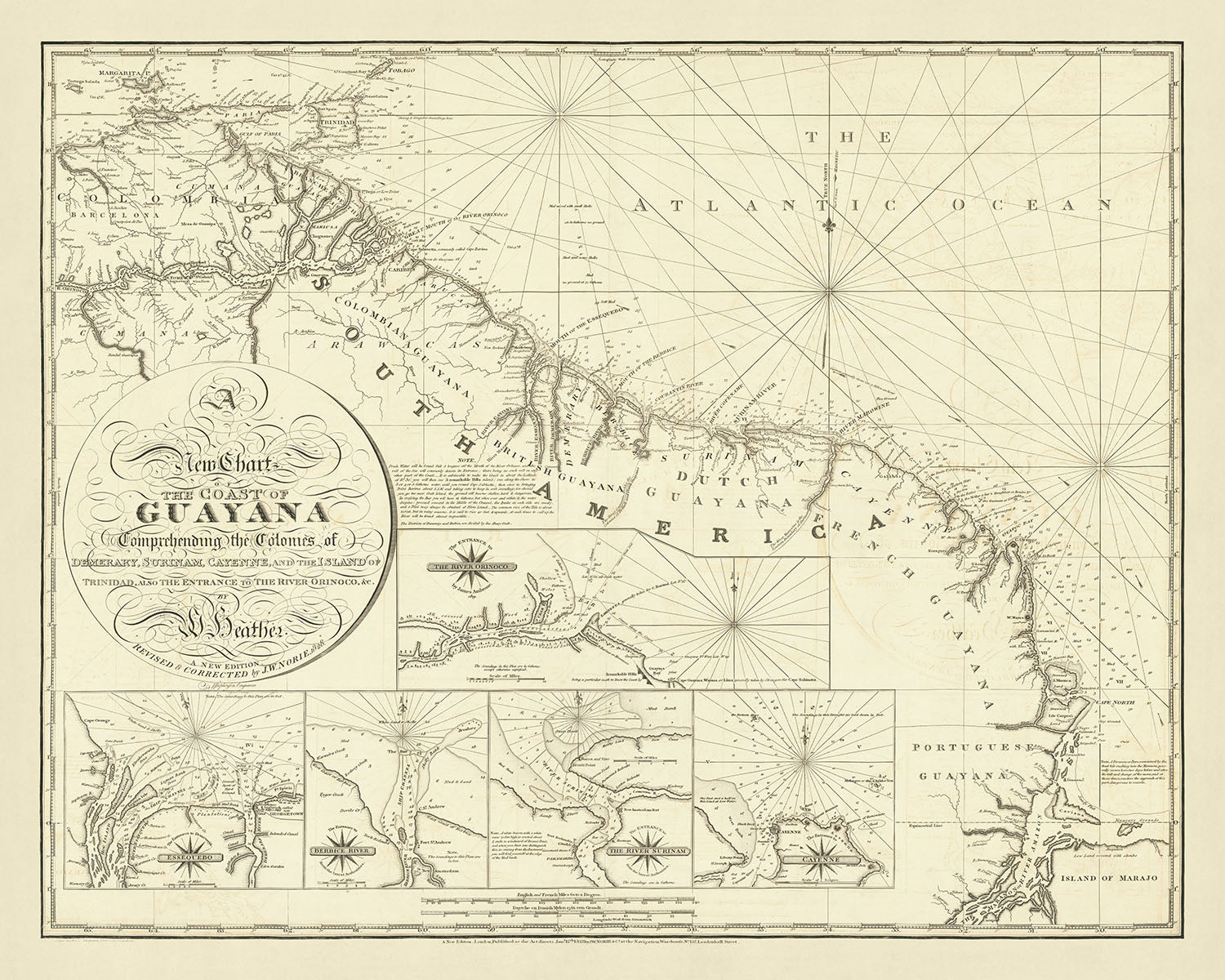
Immergiti nella ricca storia dell'inizio del XIX secolo con questa squisita carta nautica, "Una Nuova Carta della Costa della Guyana Comprendente le...
Continua a leggereImmergiti nella ricca storia dell'inizio del XIX secolo con questa squisita carta nautica, "Una Nuova Carta della Costa della Guyana Comprendente le Colonie di Demerary, Surinam, Cayenne, e l'Isola di Trinidad, anche l'Ingresso al Fiume Orinoco, &c." Creata dal rinomato cartografo William Heather nel 1828, questa mappa cattura i dettagli intricati delle regioni costiere della Guyana. Offre uno sguardo affascinante sul panorama geopolitico dell'epoca, mostrando la transizione del controllo dalle mani olandesi a quelle britanniche e l'importanza strategica di questi territori.
Il focus principale della mappa è sulle colonie costiere di Demerary, Surinam, Cayenne e Trinidad, insieme all'ingresso del Fiume Orinoco. Ognuna di queste regioni è meticolosamente dettagliata, evidenziando le rotte di navigazione, i porti e le caratteristiche costiere essenziali per la navigazione marittima. L'inclusione di rilevamenti, rose dei venti e canali navigabili sottolinea l'uso pratico della mappa per marinai ed esploratori dell'epoca. Questo livello di dettaglio non solo rende la mappa un documento storico prezioso, ma anche un'opera d'arte a sé stante.
Una delle caratteristiche più sorprendenti di questa mappa è la serie di mappe in dettaglio che offrono uno sguardo più ravvicinato ai principali ingressi fluviali e porti. Questi dettagli includono l'Ingresso al Fiume Orinoco, Essequebo, il Fiume Berbice, il Fiume Surinam e Cayenne. Ogni dettaglio è accuratamente realizzato per offrire informazioni dettagliate sulla topografia e le sfide navigazionali di queste vie d'acqua vitali. Questa attenzione al dettaglio riflette la dedizione del cartografo all'accuratezza e all'utilità, rendendola uno strumento indispensabile per comprendere la storia marittima della regione.
William Heather, il creatore della mappa, era una figura prominente nel mondo della cartografia, noto per le sue eccezionali carte nautiche. Questa particolare mappa, emessa da Norie, è una testimonianza delle abilità di Heather e degli alti standard della cartografia britannica durante questo periodo. La mappa non solo funge da aiuto alla navigazione, ma anche come documento storico della riconquista britannica delle ex colonie olandesi nel 1796 e della loro cessione formale nel 1814. Questo contesto aggiunge un livello di significato storico, rendendo la mappa un possesso prezioso per collezionisti e appassionati di storia.
Il design e lo stile della mappa riflettono le pratiche cartografiche del periodo, con contorni costieri dettagliati, rilevamenti e ausili alla navigazione. La calligrafia elegante e i design intricati dei bordi ne esaltano ulteriormente l'appeal estetico. Come pezzo raro e prezioso, questa mappa offre una finestra unica nel passato, catturando l'essenza di un'epoca in cui la navigazione marittima era cruciale per l'espansione e il controllo coloniale. Che tu sia un collezionista, uno storico o semplicemente un ammiratore della fine cartografia, questa mappa è un'aggiunta straordinaria a qualsiasi collezione.
Luoghi notevoli su questa mappa
- Demerary: Una colonia mostrata sulla mappa, parte delle ex colonie olandesi.
- Surinam: Un'altra colonia rappresentata, significativa nel contesto delle transizioni coloniali olandesi e britanniche.
- Cayenne: Una colonia francese mostrata sulla mappa, che è rimasta un Dipartimento francese.
- Isola di Trinidad: Inclusa nella mappa, evidenziando la sua posizione strategica.
- Ingresso al Fiume Orinoco: Uno dei dettagliati per scopi navigazionali.
- Essequebo: Un altro dettaglio, che mostra l'ingresso del fiume.
- Fiume Berbice: Incluso come un'inserto, importante per la navigazione.
- Fiume Surinam: Mostrato in dettaglio in uno degli inserti.
- Guayana portoghese: Contrassegnato sulla mappa, fornendo contesto geografico.
- Isola di Marajo: Inclusa per mostrare il contesto geografico più ampio della regione.
Caratteristiche e punti di riferimento notevoli
- Area geografica coperta: La regione costiera della Guyana, comprese le colonie di Demerary, Surinam, Cayenne e l'Isola di Trinidad.
- Inserti: Mappe di inserto più grandi dell'Entrata del Fiume Orinoco, Essequebo, Fiume Berbice, Fiume Surinam e Cayenne.
- Contesto coloniale: Mostra le ex colonie olandesi in Guiana alla vigilia della loro consolidazione in Guiana britannica.
- Strumenti di navigazione: Include rose dei venti, profondità (profondità dell'acqua in braccia) e canali navigabili.
- Contesto politico: Riflette la riconquista britannica della regione nel 1796 e la cessione formale delle colonie agli inglesi nel 1814.
- Rarità: La mappa è estremamente rara, con solo pochi esemplari noti in biblioteche e collezioni.
- Contesto storico: Illustra l'importanza strategica delle regioni costiere e delle entrate fluviali per la navigazione marittima e l'amministrazione coloniale.
- Contesto del cartografo: Creata da William Heather, un noto cartografo, e pubblicata da Norie.
- Elementi di design: Caratteristiche costiere dettagliate, porti e entrate fluviali essenziali per la navigazione.
- Transizioni coloniali: Sottolinea i cambiamenti di controllo dalle mani olandesi a quelle britanniche tra il 1783 e il 1814.
Contesto storico e di design
- Data di creazione: 1828
- Cartografo/Editore: William Heather, con l'edizione attuale pubblicata da Norie.
- Contesto storico del cartografo: William Heather era noto per la creazione di carte nautiche. Questa edizione è stata pubblicata da Norie dopo che gli inglesi hanno consolidato il controllo sulle ex colonie olandesi nella regione nel 1803 e la loro cessione formale agli inglesi nell'agosto del 1814.
- Temi mostrati sulla mappa: La mappa si concentra sulla navigazione nautica, mostrando regioni costiere, profondità (profondità dell'acqua in braccia) e strumenti di navigazione come rose dei venti, correnti e canali d'acqua.
- Paesi e regioni mostrati sulla mappa: La mappa copre la costa della Guyana, comprese le colonie di Demerary, Surinam, Cayenne e l'Isola di Trinidad. Include anche l'entrata del Fiume Orinoco.
- Contesto di design e stile: La mappa è una carta nautica con dettagliati inserti delle principali entrate fluviali e porti. Include profondità e strumenti di navigazione essenziali per la navigazione marittima.
- Importanza storica: La mappa illustra i cambiamenti geopolitici nella regione, in particolare la transizione di controllo dalle mani olandesi a quelle britanniche. Sottolinea anche l'importanza strategica delle regioni costiere e delle entrate fluviali per la navigazione e l'amministrazione coloniale.
Si prega di controllare attentamente le immagini per assicurarsi che una specifica città o luogo sia mostrato su questa mappa. Puoi anche contattarci e chiedere di controllare la mappa per te.
Questa mappa sembra fantastica in ogni dimensione, ma consiglio sempre di optare per una dimensione più grande se hai spazio. In questo modo puoi facilmente distinguere tutti i dettagli.
Questa mappa appare incredibile in dimensioni fino a 50in (125cm). Se stai cercando una mappa più grande, per favore contattami.
Il modello nelle immagini dell'inserzione tiene la versione 16x20in (40x50cm) di questa mappa.
La quinta immagine dell'inserzione mostra un esempio del mio servizio di personalizzazione della mappa.
Se stai cercando qualcosa di leggermente diverso, dai un'occhiata alla mia collezione dei migliori mappe antiche per vedere se qualcosa attira la tua attenzione.
Per favore contattami per verificare se una certa località, punto di riferimento o caratteristica è mostrata su questa mappa.
Questo sarebbe un meraviglioso regalo di compleanno, Natale, Festa del Papà, addio al lavoro, anniversario o per una festa di inaugurazione per qualcuno delle aree coperte da questa mappa.
Questa mappa è disponibile come stampa giclée su carta opaca archiviabile priva di acidi, oppure puoi acquistarla incorniciata. La cornice è una semplice cornice nera che si adatta alla maggior parte degli stili. Per favore contattami se desideri un colore o un materiale diverso per la cornice. Le mie cornici sono dotate di un vetro in acrilico museale super chiaro (perspex/acrylite), che è significativamente meno riflettente del vetro, più sicuro e arriverà sempre in perfette condizioni.
This map is also available as a float framed canvas, sometimes known as a shadow gap framed canvas or canvas floater. The map is printed on artist's cotton canvas and then stretched over a handmade box frame. We then "float" the canvas inside a wooden frame, which is available in a range of colours (black, dark brown, oak, antique gold and white). This is a wonderful way to present a map without glazing in front. See some examples of float framed canvas maps and explore the differences between my different finishes.
For something truly unique, this map is also available in "Unique 3D", our trademarked process that dramatically transforms the map so that it has a wonderful sense of depth. We combine the original map with detailed topography and elevation data, so that mountains and the terrain really "pop". For more info and examples of 3D maps, check my Unique 3D page.
Immergiti nella ricca storia dell'inizio del XIX secolo con questa squisita carta nautica, "Una Nuova Carta della Costa della Guyana Comprendente le Colonie di Demerary, Surinam, Cayenne, e l'Isola di Trinidad, anche l'Ingresso al Fiume Orinoco, &c." Creata dal rinomato cartografo William Heather nel 1828, questa mappa cattura i dettagli intricati delle regioni costiere della Guyana. Offre uno sguardo affascinante sul panorama geopolitico dell'epoca, mostrando la transizione del controllo dalle mani olandesi a quelle britanniche e l'importanza strategica di questi territori.
Il focus principale della mappa è sulle colonie costiere di Demerary, Surinam, Cayenne e Trinidad, insieme all'ingresso del Fiume Orinoco. Ognuna di queste regioni è meticolosamente dettagliata, evidenziando le rotte di navigazione, i porti e le caratteristiche costiere essenziali per la navigazione marittima. L'inclusione di rilevamenti, rose dei venti e canali navigabili sottolinea l'uso pratico della mappa per marinai ed esploratori dell'epoca. Questo livello di dettaglio non solo rende la mappa un documento storico prezioso, ma anche un'opera d'arte a sé stante.
Una delle caratteristiche più sorprendenti di questa mappa è la serie di mappe in dettaglio che offrono uno sguardo più ravvicinato ai principali ingressi fluviali e porti. Questi dettagli includono l'Ingresso al Fiume Orinoco, Essequebo, il Fiume Berbice, il Fiume Surinam e Cayenne. Ogni dettaglio è accuratamente realizzato per offrire informazioni dettagliate sulla topografia e le sfide navigazionali di queste vie d'acqua vitali. Questa attenzione al dettaglio riflette la dedizione del cartografo all'accuratezza e all'utilità, rendendola uno strumento indispensabile per comprendere la storia marittima della regione.
William Heather, il creatore della mappa, era una figura prominente nel mondo della cartografia, noto per le sue eccezionali carte nautiche. Questa particolare mappa, emessa da Norie, è una testimonianza delle abilità di Heather e degli alti standard della cartografia britannica durante questo periodo. La mappa non solo funge da aiuto alla navigazione, ma anche come documento storico della riconquista britannica delle ex colonie olandesi nel 1796 e della loro cessione formale nel 1814. Questo contesto aggiunge un livello di significato storico, rendendo la mappa un possesso prezioso per collezionisti e appassionati di storia.
Il design e lo stile della mappa riflettono le pratiche cartografiche del periodo, con contorni costieri dettagliati, rilevamenti e ausili alla navigazione. La calligrafia elegante e i design intricati dei bordi ne esaltano ulteriormente l'appeal estetico. Come pezzo raro e prezioso, questa mappa offre una finestra unica nel passato, catturando l'essenza di un'epoca in cui la navigazione marittima era cruciale per l'espansione e il controllo coloniale. Che tu sia un collezionista, uno storico o semplicemente un ammiratore della fine cartografia, questa mappa è un'aggiunta straordinaria a qualsiasi collezione.
Luoghi notevoli su questa mappa
- Demerary: Una colonia mostrata sulla mappa, parte delle ex colonie olandesi.
- Surinam: Un'altra colonia rappresentata, significativa nel contesto delle transizioni coloniali olandesi e britanniche.
- Cayenne: Una colonia francese mostrata sulla mappa, che è rimasta un Dipartimento francese.
- Isola di Trinidad: Inclusa nella mappa, evidenziando la sua posizione strategica.
- Ingresso al Fiume Orinoco: Uno dei dettagliati per scopi navigazionali.
- Essequebo: Un altro dettaglio, che mostra l'ingresso del fiume.
- Fiume Berbice: Incluso come un'inserto, importante per la navigazione.
- Fiume Surinam: Mostrato in dettaglio in uno degli inserti.
- Guayana portoghese: Contrassegnato sulla mappa, fornendo contesto geografico.
- Isola di Marajo: Inclusa per mostrare il contesto geografico più ampio della regione.
Caratteristiche e punti di riferimento notevoli
- Area geografica coperta: La regione costiera della Guyana, comprese le colonie di Demerary, Surinam, Cayenne e l'Isola di Trinidad.
- Inserti: Mappe di inserto più grandi dell'Entrata del Fiume Orinoco, Essequebo, Fiume Berbice, Fiume Surinam e Cayenne.
- Contesto coloniale: Mostra le ex colonie olandesi in Guiana alla vigilia della loro consolidazione in Guiana britannica.
- Strumenti di navigazione: Include rose dei venti, profondità (profondità dell'acqua in braccia) e canali navigabili.
- Contesto politico: Riflette la riconquista britannica della regione nel 1796 e la cessione formale delle colonie agli inglesi nel 1814.
- Rarità: La mappa è estremamente rara, con solo pochi esemplari noti in biblioteche e collezioni.
- Contesto storico: Illustra l'importanza strategica delle regioni costiere e delle entrate fluviali per la navigazione marittima e l'amministrazione coloniale.
- Contesto del cartografo: Creata da William Heather, un noto cartografo, e pubblicata da Norie.
- Elementi di design: Caratteristiche costiere dettagliate, porti e entrate fluviali essenziali per la navigazione.
- Transizioni coloniali: Sottolinea i cambiamenti di controllo dalle mani olandesi a quelle britanniche tra il 1783 e il 1814.
Contesto storico e di design
- Data di creazione: 1828
- Cartografo/Editore: William Heather, con l'edizione attuale pubblicata da Norie.
- Contesto storico del cartografo: William Heather era noto per la creazione di carte nautiche. Questa edizione è stata pubblicata da Norie dopo che gli inglesi hanno consolidato il controllo sulle ex colonie olandesi nella regione nel 1803 e la loro cessione formale agli inglesi nell'agosto del 1814.
- Temi mostrati sulla mappa: La mappa si concentra sulla navigazione nautica, mostrando regioni costiere, profondità (profondità dell'acqua in braccia) e strumenti di navigazione come rose dei venti, correnti e canali d'acqua.
- Paesi e regioni mostrati sulla mappa: La mappa copre la costa della Guyana, comprese le colonie di Demerary, Surinam, Cayenne e l'Isola di Trinidad. Include anche l'entrata del Fiume Orinoco.
- Contesto di design e stile: La mappa è una carta nautica con dettagliati inserti delle principali entrate fluviali e porti. Include profondità e strumenti di navigazione essenziali per la navigazione marittima.
- Importanza storica: La mappa illustra i cambiamenti geopolitici nella regione, in particolare la transizione di controllo dalle mani olandesi a quelle britanniche. Sottolinea anche l'importanza strategica delle regioni costiere e delle entrate fluviali per la navigazione e l'amministrazione coloniale.
Si prega di controllare attentamente le immagini per assicurarsi che una specifica città o luogo sia mostrato su questa mappa. Puoi anche contattarci e chiedere di controllare la mappa per te.
Questa mappa sembra fantastica in ogni dimensione, ma consiglio sempre di optare per una dimensione più grande se hai spazio. In questo modo puoi facilmente distinguere tutti i dettagli.
Questa mappa appare incredibile in dimensioni fino a 50in (125cm). Se stai cercando una mappa più grande, per favore contattami.
Il modello nelle immagini dell'inserzione tiene la versione 16x20in (40x50cm) di questa mappa.
La quinta immagine dell'inserzione mostra un esempio del mio servizio di personalizzazione della mappa.
Se stai cercando qualcosa di leggermente diverso, dai un'occhiata alla mia collezione dei migliori mappe antiche per vedere se qualcosa attira la tua attenzione.
Per favore contattami per verificare se una certa località, punto di riferimento o caratteristica è mostrata su questa mappa.
Questo sarebbe un meraviglioso regalo di compleanno, Natale, Festa del Papà, addio al lavoro, anniversario o per una festa di inaugurazione per qualcuno delle aree coperte da questa mappa.
Questa mappa è disponibile come stampa giclée su carta opaca archiviabile priva di acidi, oppure puoi acquistarla incorniciata. La cornice è una semplice cornice nera che si adatta alla maggior parte degli stili. Per favore contattami se desideri un colore o un materiale diverso per la cornice. Le mie cornici sono dotate di un vetro in acrilico museale super chiaro (perspex/acrylite), che è significativamente meno riflettente del vetro, più sicuro e arriverà sempre in perfette condizioni.
This map is also available as a float framed canvas, sometimes known as a shadow gap framed canvas or canvas floater. The map is printed on artist's cotton canvas and then stretched over a handmade box frame. We then "float" the canvas inside a wooden frame, which is available in a range of colours (black, dark brown, oak, antique gold and white). This is a wonderful way to present a map without glazing in front. See some examples of float framed canvas maps and explore the differences between my different finishes.
For something truly unique, this map is also available in "Unique 3D", our trademarked process that dramatically transforms the map so that it has a wonderful sense of depth. We combine the original map with detailed topography and elevation data, so that mountains and the terrain really "pop". For more info and examples of 3D maps, check my Unique 3D page.
Many of our maps and art prints are chosen as thoughtful gifts for homes, offices, studies and meaningful places.
Choose a framed option for the easiest ready-to-hang gift, or choose an unframed print if the recipient may prefer to select their own frame.
We make orders locally in 23 countries around the world, so gifts can often be produced close to the recipient. This helps them arrive faster, travel more safely, and avoid customs or import duty surprises.
- We can deliver directly to the recipient
- Framed pieces arrive ready to hang
- Unframed prints are carefully packed in a strong protective tube
- Almost every order is made locally, for faster, safer gifting
- 90-day returns give the recipient time to decide
If you are not sure what to choose, please contact us. We can help you pick the right map, size, finish or delivery option.
Most orders are made locally and delivered in around 2–3 working days, depending on the product, size and destination.
We print and frame maps and artwork in 23 countries around the world, so your order is usually made close to you or your recipient. That means faster delivery, less time in transit, and no customs or import duty surprises.
Personalised and customised pieces usually take an extra 1–2 working days, because we prepare your design and send it to you for approval before printing.
Very large framed orders can take a little longer, as they need extra care in production and delivery.
Every order is carefully packaged: unframed prints are sent in a strong protective tube, while framed pieces are securely packed with protective materials around the frame.
If you need your order by a particular date, please contact us before ordering. We’ll check the best production route and delivery option for your location.
Express delivery is available at checkout for most countries. Next-day delivery is available in the UK, US, Singapore and the UAE.
Your order is covered by our 90-day returns policy and 10-year guarantee.
Our standard frame is a gallery-style black ash hardwood frame, with a simple, modern look. It is approximately 20mm (0.8in) wide. You can also view some lovely customer photos of framed maps and art.
We use super-clear acrylic glazing, also known as Perspex or Acrylite, instead of traditional glass. It is lighter, safer, and has lower reflectivity, giving the artwork a clearer, cleaner appearance.
Six standard frame colours are available at no extra cost: black, dark brown, dark grey, oak, white, and antique gold. Custom framing and mounting/matting is also available for customers looking for something more specific.
Most maps, art prints, and illustrations are also available as a framed canvas. We use matte cotton canvas, stretch it over a sustainably sourced wooden box frame, and then float the piece within a wooden outer frame. The finished result is beautifully presented, with no glazing between you and the artwork.
All frames are supplied ready to hang, with either string or brackets fitted to the back. Very large frames will include heavy-duty hanging plates and/or a mounting baton. If you have any questions, please get in touch.
We can also supply old maps and artwork on canvas, foam board, cotton rag, and other materials.
If you would prefer to frame your map or artwork yourself, please read our size guide before ordering.
My maps are extremely high quality reproductions of original maps.
I source original, rare maps from libraries, auction houses and private collections around the world, restore them at my London workshop, and then use specialist giclée inks and printers to create beautiful maps that look even better than the original.
My maps are printed on acid-free archival matte (not glossy) paper that feels very high quality and almost like card. In technical terms the paper weight/thickness is 10mil/200gsm. It's perfect for framing.
I print with Epson ultrachrome giclée UV fade resistant pigment inks - some of the best inks you can find.
I can also make maps on canvas, cotton rag and other exotic materials.
Learn more about The Unique Maps Co.
Map personalisation
If you're looking for the perfect anniversary or housewarming gift, I can personalise your map to make it truly unique. For example, I can add a short message, or highlight an important location, or add your family's coat of arms.
The options are almost infinite. Please see my map personalisation page for some wonderful examples of what's possible.
To order a personalised map, select "personalise your map" before adding it to your basket.
Get in touch if you're looking for more complex customisations and personalisations.
Map ageing
I have been asked hundreds of times over the years by customers if they could buy a map that looks even older.
Well, now you can, by selecting Aged before you add a map to your basket.
All the product photos you see on this page show the map in its Original form. This is what the map looks like today.
If you select Aged, I will age your map by hand, using a special and unique process developed through years of studying old maps, talking to researchers to understand the chemistry of aging paper, and of course... lots of practice!
If you're unsure, stick to the Original colour of the map. If you want something a bit darker and older looking, go for Aged.
Se non sei soddisfatto del tuo ordine per qualsiasi motivo, contattami per un rimborso senza problemi. Si prega di consultare la nostra politica di reso e rimborso per ulteriori informazioni.
Sono molto sicuro che ti piacerà la tua mappa restaurata o la stampa d'arte. Lo faccio dal 1984. Sono un venditore Etsy a 5 stelle. Ho venduto decine di migliaia di mappe e stampe d'arte e ho oltre 5.000 recensioni reali a 5 stelle.
Utilizzo un processo unico per restaurare mappe e opere d'arte che richiede molto tempo e lavoro. Trovare le mappe e le illustrazioni originali può richiedere mesi. Utilizzo tecnologia all'avanguardia e incredibilmente costosa per scannerizzare e restaurarle. Di conseguenza, garantisco che le mie mappe e stampe d'arte siano superiori alle altre - ecco perché posso offrire un rimborso senza problemi.
Quasi tutte le mie mappe e stampe d'arte sembrano fantastiche a grandi dimensioni (200 cm, 6,5 piedi+) e posso anche incorniciarle e consegnarle a te, tramite un corriere speciale per oggetti di grandi dimensioni. Contattami per discutere delle tue esigenze specifiche.
Or try searching for something!


