


Prima Grande Mappa della Catalogna di Aparici, 1769: Barcellona, Girona, Pirenei, Fiume Ebro, Borboni
L’offerta del Collezionista
Scegli due opere idonee e ricevi il 20% di sconto su entrambe. Scegline tre e quella al prezzo più basso è in omaggio, con un risparmio massimo del 33%.
Abbina liberamente mappe standard idonee e stampe d’arte fine art. Non è richiesto alcun codice; l’offerta viene applicata automaticamente al checkout.
Sono incluse le configurazioni standard su ordinazione. Sono esclusi formati su misura, design personalizzati e lavori su commissione.
Hai bisogno di consegne a indirizzi diversi? Contattaci prima di effettuare l’ordine.L’offerta del Collezionista
Scegli due opere idonee e ricevi il 20% di sconto su entrambe. Scegline tre e quella al prezzo più basso è in omaggio, con un risparmio massimo del 33%.
Abbina liberamente mappe standard idonee e stampe d’arte fine art. Non è richiesto alcun codice; l’offerta viene applicata automaticamente al checkout.
Sono incluse le configurazioni standard su ordinazione. Sono esclusi formati su misura, design personalizzati e lavori su commissione.
Hai bisogno di consegne a indirizzi diversi? Contattaci prima di effettuare l’ordine. Progettato a Londra Prodotto in the USA
Progettato a Londra • Prodotto in the USA
Progettato a Londra Prodotto in the USA
Progettato a Londra • Prodotto in the USA

Restaurata dalla mappa originale del 1720 e stampata in qualità museale. Leggi la storia dietro questa mappa
Choose your size
Choose your finish


(Maggiori informazioni)
Gift message & custom finish

If you want to add a gift message, or a finish (jigsaw, aluminium board, etc.) that is not available here, please request it in the "order note" when you check out.
Every order is custom made, so if you need the size adjusted slightly, or printed on an unusual material, just let us know. We've done thousands of custom orders over the years, so there's (almost) nothing we can't manage.
You can also contact us before you order, if you prefer!

- Prodotto localmente. Consegna sicura
- Nessun dazio o costo nascosto
- Serve aiuto? Chiamaci o messaggio su WhatsApp
Own a piece of history
8,000+ five-star reviews


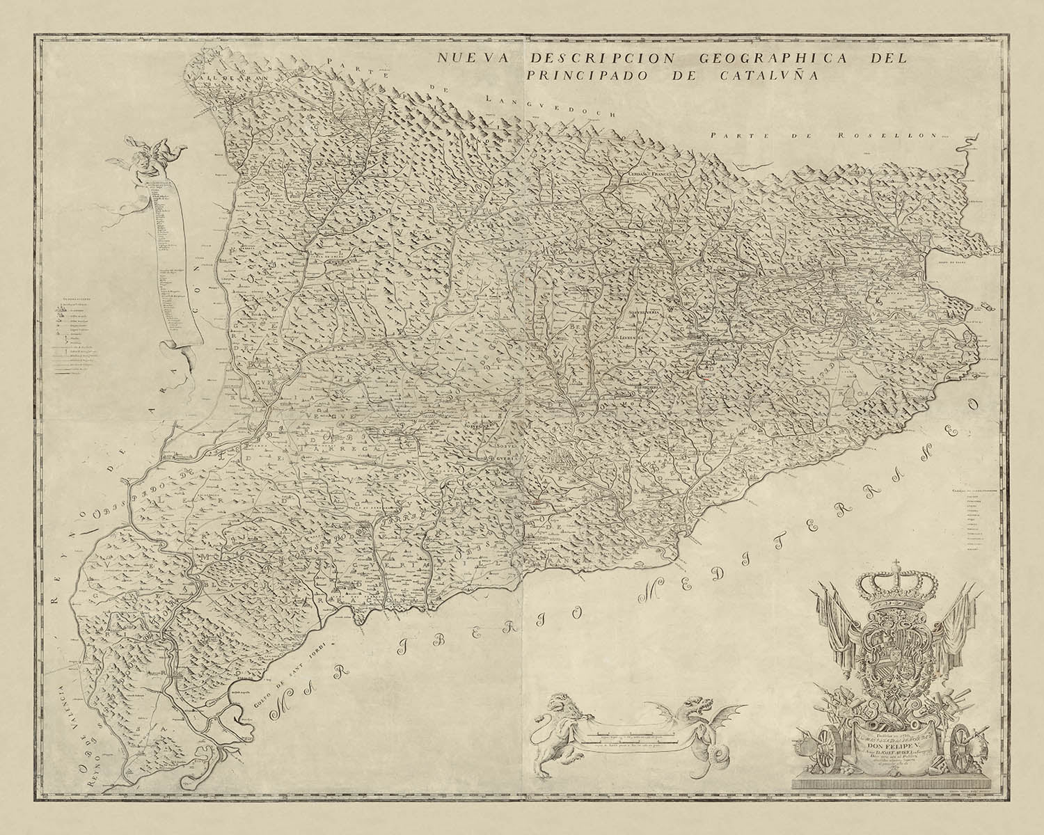
Entra nella ricca trama della Catalogna del XVIII secolo con questa eccezionale mappa, intitolata "Nueva Descripcion Geographica Del Principado De Cataluña." Realizzata...
Continua a leggereEntra nella ricca trama della Catalogna del XVIII secolo con questa eccezionale mappa, intitolata "Nueva Descripcion Geographica Del Principado De Cataluña." Realizzata dal distinto geografo catalano e funzionario della Corona Josep Aparici, questa mappa è celebrata come la prima rappresentazione in grande formato della Catalogna creata da un nativo. Pubblicata per la prima volta nel 1720 e perfezionata in questa edizione del 1769, l'opera di Aparici si erge come un testamento allo spirito duraturo della regione e al suo complesso viaggio storico. I dettagli intricati della mappa e i suoi tocchi barocchi catturano immediatamente l'occhio, invitando lo spettatore a esplorare un paesaggio plasmato da montagne, fiumi e secoli di tumulto politico.
Josep Aparici non era semplicemente un cartografo, ma una figura fondamentale nella trasformazione amministrativa della Catalogna. Come ufficiale fidato sotto la monarchia borbonica, Aparici attraversò la regione dopo la Guerra di Successione Spagnola, raccogliendo meticolosamente dati per i nuovi corregimenti—divisioni amministrative imposte dopo la vittoria borbonica. La sua mappa è una cronaca vivida di quest'epoca, rivelando sia la grandezza fisica dei Pirenei che la costa mediterranea, così come il nuovo ordine politico imposto. L'alleanza di Aparici con il re Filippo V è indiscutibilmente intrecciata nel tessuto stesso della mappa, con un elaborato cartiglio che celebra il trionfo e l'autorità borbonica.
L'arte della mappa di Aparici è eguagliata solo dalla sua risonanza storica. Gli elementi decorativi abbondano: un ornato cartiglio dedicato adornato con lo stemma borbonico e trofei marziali, una scala di distanza sorretta da un leone e un drago, e un cherubino che srotola un pergamena con l'elenco delle rettorie della regione. Questi tocchi non sono semplici abbellimenti—sono narrazioni visive, che riflettono l'orgoglio, il conflitto e la trasformazione che hanno definito la Catalogna all'inizio del XVIII secolo. Il design della mappa è una lezione magistrale nella cartografia barocca, mescolando precisione scientifica con ricchezza allegorica.
Geograficamente, la mappa cattura i drammatici contrasti del terreno catalano. I maestosi Pirenei formano un confine naturale a nord, mentre la soleggiata costa mediterranea si estende invitante verso est. Fiumi come l'Ebro si snodano attraverso il paesaggio, i cui corsi sono chiaramente delineati accanto alle vitali reti stradali della regione. La rappresentazione attenta della mappa del rilievo montuoso e delle vie d'acqua sottolinea sia la bellezza che l'importanza strategica di questa terra storica. I confini sono tracciati con meticolosità, con le regioni settentrionali etichettate come "Parte di Langeudoch," riconoscendo la prossimità della regione alla Francia e il suo ruolo come crocevia di culture e conflitti.
La mappa di Aparici è anche una finestra sulla vivace vita urbana della Catalogna del XVIII secolo. Città principali come Barcellona, Tarragona, Girona e Lleida sono presentate in modo prominente, insieme a una costellazione di paesi—Reus, Sabadell, Terrassa e altri—che sarebbero cresciuti per definire l'identità moderna della regione. Questi insediamenti, tracciati meticolosamente, riflettono il battito sociale ed economico del principato. Sia come opera d'arte che come documento di cambiamento politico, la "Nueva Descripcion Geographica Del Principado De Cataluña" di Aparici rimane un raro e affascinante artefatto—un invito a esplorare i paesaggi, le storie e le ambizioni di una regione orgogliosa e resiliente.
Città e paesi su questa mappa
- Barcellona
- Tarragona
- Lleida (Lérida)
- Girona (Gerona)
- Reus
- Sabadell
- Terrassa
- Mataró
- Manresa
- Granollers
- Igualada
- Vic
- Figueres
- Olot
- Vilanova i la Geltrù
- Blanes
- Ripoll
- Cervera
- Tortosa
- La Seu d'Urgell
Caratteristiche e monumenti notevoli
- La catena montuosa dei Pirenei, che forma il confine settentrionale della Catalogna
- La costa mediterranea lungo il bordo orientale della regione
- Fiumi principali, incluso l'Ebro (Ebre) e altri chiaramente segnati
- Divisioni amministrative (corregimenti) imposte dalla monarchia borbonica
- Il confine con il Languedoc francese, etichettato "Parte di Langeudoch"
- Un elaborato cartiglio dedicato con lo stemma borbonico e trofei di guerra, simbolo della vittoria borbonica
- Una scala di distanza mostrata su uno stendardo tenuto da un leone e un drago
- Una chiave e un elenco di rettorie (divisioni ecclesiastiche) su una pergamena srotolata da un cherubino
- Reti stradali che collegano i principali insediamenti e regioni
- Terreno montuoso rappresentato con rilievo in ombra e hachures
- Abbellimenti decorativi tipici della cartografia barocca, come cornici ornate e figure allegoriche
Contesto storico e di design
- La prima mappa in grande formato della Catalogna pubblicata da un catalano, Josep Aparici, nel 1720 (questa edizione 1769)
- Creata dopo la Guerra di Successione Spagnola e durante la riorganizzazione e repressione borbonica della Catalogna
- Mostra i corregimenti, nuove divisioni amministrative imposte dalla monarchia borbonica dopo aver represso le istituzioni catalane e l'autonomia
- Segnò un cambiamento da Catalogna come consumatore di mappe a produttore di mappe, rappresentando un marchio della cartografia domestica catalana nel XVIII secolo
- Dedica al Re Filippo V, segnalando l'alleanza di Aparici con la monarchia borbonica
- Sia le edizioni del 1720 che del 1769 sono estremamente rare, con solo un numero esiguo di copie istituzionali conosciute
- La mappa divenne la mappa più consultata e riprodotta della Catalogna, influenzando la cartografia fino al XIX e XX secolo
- Caratterizza una fusione di precisione scientifica e ricchezza allegorica, tipica della cartografia barocca
Si prega di controllare attentamente le immagini per assicurarsi che una specifica città o luogo sia mostrato su questa mappa. Puoi anche contattarci e chiedere di controllare la mappa per te.
Questa mappa appare fantastica in ogni dimensione, ma consiglio sempre di optare per una dimensione più grande se hai spazio. In questo modo puoi facilmente distinguere tutti i dettagli.
Questa mappa appare straordinaria in dimensioni fino a 100 in (250 cm). Se stai cercando una mappa più grande, per favore contattaci.
Si prega di notare: le etichette su questa mappa sono difficili da leggere se ordini una mappa che è 20 in (50 cm) o più piccola. La mappa è comunque molto attraente, ma se desideri leggere facilmente la mappa, ti preghiamo di acquistare una dimensione più grande.
Il modello nelle immagini dell'elenco sta tenendo la versione 16x20 in (40x50 cm) di questa mappa.
La quinta immagine dell'elenco mostra un esempio del mio servizio di personalizzazione della mappa.
Se stai cercando qualcosa di leggermente diverso, dai un'occhiata alla mia collezione delle migliori mappe antiche per vedere se qualcosa attira la tua attenzione.
Per favore contattami per controllare se una certa posizione, monumento o caratteristica è mostrata su questa mappa.
Questo sarebbe un meraviglioso regalo di compleanno, Natale, Festa del Papà, di pensionamento, anniversario o di inaugurazione della casa per qualcuno delle aree coperte da questa mappa.
Questa mappa è disponibile come stampa giclée su carta opaca archiviabile senza acidi, oppure puoi acquistarla incorniciata. La cornice è una bella e semplice cornice nera che si adatta alla maggior parte degli stili. Ti preghiamo di contattarci se desideri un colore o un materiale diverso per la cornice. Le mie cornici sono dotate di un vetro acrilico super chiaro di qualità museale (perspex/acrylite), che è significativamente meno riflettente del vetro, più sicuro e arriverà sempre in condizioni perfette.
This map is also available as a float framed canvas, sometimes known as a shadow gap framed canvas or canvas floater. The map is printed on artist's cotton canvas and then stretched over a handmade box frame. We then "float" the canvas inside a wooden frame, which is available in a range of colours (black, dark brown, oak, antique gold and white). This is a wonderful way to present a map without glazing in front. See some examples of float framed canvas maps and explore the differences between my different finishes.
For something truly unique, this map is also available in "Unique 3D", our trademarked process that dramatically transforms the map so that it has a wonderful sense of depth. We combine the original map with detailed topography and elevation data, so that mountains and the terrain really "pop". For more info and examples of 3D maps, check my Unique 3D page.
Entra nella ricca trama della Catalogna del XVIII secolo con questa eccezionale mappa, intitolata "Nueva Descripcion Geographica Del Principado De Cataluña." Realizzata dal distinto geografo catalano e funzionario della Corona Josep Aparici, questa mappa è celebrata come la prima rappresentazione in grande formato della Catalogna creata da un nativo. Pubblicata per la prima volta nel 1720 e perfezionata in questa edizione del 1769, l'opera di Aparici si erge come un testamento allo spirito duraturo della regione e al suo complesso viaggio storico. I dettagli intricati della mappa e i suoi tocchi barocchi catturano immediatamente l'occhio, invitando lo spettatore a esplorare un paesaggio plasmato da montagne, fiumi e secoli di tumulto politico.
Josep Aparici non era semplicemente un cartografo, ma una figura fondamentale nella trasformazione amministrativa della Catalogna. Come ufficiale fidato sotto la monarchia borbonica, Aparici attraversò la regione dopo la Guerra di Successione Spagnola, raccogliendo meticolosamente dati per i nuovi corregimenti—divisioni amministrative imposte dopo la vittoria borbonica. La sua mappa è una cronaca vivida di quest'epoca, rivelando sia la grandezza fisica dei Pirenei che la costa mediterranea, così come il nuovo ordine politico imposto. L'alleanza di Aparici con il re Filippo V è indiscutibilmente intrecciata nel tessuto stesso della mappa, con un elaborato cartiglio che celebra il trionfo e l'autorità borbonica.
L'arte della mappa di Aparici è eguagliata solo dalla sua risonanza storica. Gli elementi decorativi abbondano: un ornato cartiglio dedicato adornato con lo stemma borbonico e trofei marziali, una scala di distanza sorretta da un leone e un drago, e un cherubino che srotola un pergamena con l'elenco delle rettorie della regione. Questi tocchi non sono semplici abbellimenti—sono narrazioni visive, che riflettono l'orgoglio, il conflitto e la trasformazione che hanno definito la Catalogna all'inizio del XVIII secolo. Il design della mappa è una lezione magistrale nella cartografia barocca, mescolando precisione scientifica con ricchezza allegorica.
Geograficamente, la mappa cattura i drammatici contrasti del terreno catalano. I maestosi Pirenei formano un confine naturale a nord, mentre la soleggiata costa mediterranea si estende invitante verso est. Fiumi come l'Ebro si snodano attraverso il paesaggio, i cui corsi sono chiaramente delineati accanto alle vitali reti stradali della regione. La rappresentazione attenta della mappa del rilievo montuoso e delle vie d'acqua sottolinea sia la bellezza che l'importanza strategica di questa terra storica. I confini sono tracciati con meticolosità, con le regioni settentrionali etichettate come "Parte di Langeudoch," riconoscendo la prossimità della regione alla Francia e il suo ruolo come crocevia di culture e conflitti.
La mappa di Aparici è anche una finestra sulla vivace vita urbana della Catalogna del XVIII secolo. Città principali come Barcellona, Tarragona, Girona e Lleida sono presentate in modo prominente, insieme a una costellazione di paesi—Reus, Sabadell, Terrassa e altri—che sarebbero cresciuti per definire l'identità moderna della regione. Questi insediamenti, tracciati meticolosamente, riflettono il battito sociale ed economico del principato. Sia come opera d'arte che come documento di cambiamento politico, la "Nueva Descripcion Geographica Del Principado De Cataluña" di Aparici rimane un raro e affascinante artefatto—un invito a esplorare i paesaggi, le storie e le ambizioni di una regione orgogliosa e resiliente.
Città e paesi su questa mappa
- Barcellona
- Tarragona
- Lleida (Lérida)
- Girona (Gerona)
- Reus
- Sabadell
- Terrassa
- Mataró
- Manresa
- Granollers
- Igualada
- Vic
- Figueres
- Olot
- Vilanova i la Geltrù
- Blanes
- Ripoll
- Cervera
- Tortosa
- La Seu d'Urgell
Caratteristiche e monumenti notevoli
- La catena montuosa dei Pirenei, che forma il confine settentrionale della Catalogna
- La costa mediterranea lungo il bordo orientale della regione
- Fiumi principali, incluso l'Ebro (Ebre) e altri chiaramente segnati
- Divisioni amministrative (corregimenti) imposte dalla monarchia borbonica
- Il confine con il Languedoc francese, etichettato "Parte di Langeudoch"
- Un elaborato cartiglio dedicato con lo stemma borbonico e trofei di guerra, simbolo della vittoria borbonica
- Una scala di distanza mostrata su uno stendardo tenuto da un leone e un drago
- Una chiave e un elenco di rettorie (divisioni ecclesiastiche) su una pergamena srotolata da un cherubino
- Reti stradali che collegano i principali insediamenti e regioni
- Terreno montuoso rappresentato con rilievo in ombra e hachures
- Abbellimenti decorativi tipici della cartografia barocca, come cornici ornate e figure allegoriche
Contesto storico e di design
- La prima mappa in grande formato della Catalogna pubblicata da un catalano, Josep Aparici, nel 1720 (questa edizione 1769)
- Creata dopo la Guerra di Successione Spagnola e durante la riorganizzazione e repressione borbonica della Catalogna
- Mostra i corregimenti, nuove divisioni amministrative imposte dalla monarchia borbonica dopo aver represso le istituzioni catalane e l'autonomia
- Segnò un cambiamento da Catalogna come consumatore di mappe a produttore di mappe, rappresentando un marchio della cartografia domestica catalana nel XVIII secolo
- Dedica al Re Filippo V, segnalando l'alleanza di Aparici con la monarchia borbonica
- Sia le edizioni del 1720 che del 1769 sono estremamente rare, con solo un numero esiguo di copie istituzionali conosciute
- La mappa divenne la mappa più consultata e riprodotta della Catalogna, influenzando la cartografia fino al XIX e XX secolo
- Caratterizza una fusione di precisione scientifica e ricchezza allegorica, tipica della cartografia barocca
Si prega di controllare attentamente le immagini per assicurarsi che una specifica città o luogo sia mostrato su questa mappa. Puoi anche contattarci e chiedere di controllare la mappa per te.
Questa mappa appare fantastica in ogni dimensione, ma consiglio sempre di optare per una dimensione più grande se hai spazio. In questo modo puoi facilmente distinguere tutti i dettagli.
Questa mappa appare straordinaria in dimensioni fino a 100 in (250 cm). Se stai cercando una mappa più grande, per favore contattaci.
Si prega di notare: le etichette su questa mappa sono difficili da leggere se ordini una mappa che è 20 in (50 cm) o più piccola. La mappa è comunque molto attraente, ma se desideri leggere facilmente la mappa, ti preghiamo di acquistare una dimensione più grande.
Il modello nelle immagini dell'elenco sta tenendo la versione 16x20 in (40x50 cm) di questa mappa.
La quinta immagine dell'elenco mostra un esempio del mio servizio di personalizzazione della mappa.
Se stai cercando qualcosa di leggermente diverso, dai un'occhiata alla mia collezione delle migliori mappe antiche per vedere se qualcosa attira la tua attenzione.
Per favore contattami per controllare se una certa posizione, monumento o caratteristica è mostrata su questa mappa.
Questo sarebbe un meraviglioso regalo di compleanno, Natale, Festa del Papà, di pensionamento, anniversario o di inaugurazione della casa per qualcuno delle aree coperte da questa mappa.
Questa mappa è disponibile come stampa giclée su carta opaca archiviabile senza acidi, oppure puoi acquistarla incorniciata. La cornice è una bella e semplice cornice nera che si adatta alla maggior parte degli stili. Ti preghiamo di contattarci se desideri un colore o un materiale diverso per la cornice. Le mie cornici sono dotate di un vetro acrilico super chiaro di qualità museale (perspex/acrylite), che è significativamente meno riflettente del vetro, più sicuro e arriverà sempre in condizioni perfette.
This map is also available as a float framed canvas, sometimes known as a shadow gap framed canvas or canvas floater. The map is printed on artist's cotton canvas and then stretched over a handmade box frame. We then "float" the canvas inside a wooden frame, which is available in a range of colours (black, dark brown, oak, antique gold and white). This is a wonderful way to present a map without glazing in front. See some examples of float framed canvas maps and explore the differences between my different finishes.
For something truly unique, this map is also available in "Unique 3D", our trademarked process that dramatically transforms the map so that it has a wonderful sense of depth. We combine the original map with detailed topography and elevation data, so that mountains and the terrain really "pop". For more info and examples of 3D maps, check my Unique 3D page.
Many of our maps and art prints are chosen as thoughtful gifts for homes, offices, studies and meaningful places.
Choose a framed option for the easiest ready-to-hang gift, or choose an unframed print if the recipient may prefer to select their own frame.
We make orders locally in 23 countries around the world, so gifts can often be produced close to the recipient. This helps them arrive faster, travel more safely, and avoid customs or import duty surprises.
- We can deliver directly to the recipient
- Framed pieces arrive ready to hang
- Unframed prints are carefully packed in a strong protective tube
- Almost every order is made locally, for faster, safer gifting
- 90-day returns give the recipient time to decide
If you are not sure what to choose, please contact us. We can help you pick the right map, size, finish or delivery option.
Most orders are made locally and delivered in around 2–3 working days, depending on the product, size and destination.
We print and frame maps and artwork in 23 countries around the world, so your order is usually made close to you or your recipient. That means faster delivery, less time in transit, and no customs or import duty surprises.
Personalised and customised pieces usually take an extra 1–2 working days, because we prepare your design and send it to you for approval before printing.
Very large framed orders can take a little longer, as they need extra care in production and delivery.
Every order is carefully packaged: unframed prints are sent in a strong protective tube, while framed pieces are securely packed with protective materials around the frame.
If you need your order by a particular date, please contact us before ordering. We’ll check the best production route and delivery option for your location.
Express delivery is available at checkout for most countries. Next-day delivery is available in the UK, US, Singapore and the UAE.
Your order is covered by our 90-day returns policy and 10-year guarantee.
Our standard frame is a gallery-style black ash hardwood frame, with a simple, modern look. It is approximately 20mm (0.8in) wide. You can also view some lovely customer photos of framed maps and art.
We use super-clear acrylic glazing, also known as Perspex or Acrylite, instead of traditional glass. It is lighter, safer, and has lower reflectivity, giving the artwork a clearer, cleaner appearance.
Six standard frame colours are available at no extra cost: black, dark brown, dark grey, oak, white, and antique gold. Custom framing and mounting/matting is also available for customers looking for something more specific.
Most maps, art prints, and illustrations are also available as a framed canvas. We use matte cotton canvas, stretch it over a sustainably sourced wooden box frame, and then float the piece within a wooden outer frame. The finished result is beautifully presented, with no glazing between you and the artwork.
All frames are supplied ready to hang, with either string or brackets fitted to the back. Very large frames will include heavy-duty hanging plates and/or a mounting baton. If you have any questions, please get in touch.
We can also supply old maps and artwork on canvas, foam board, cotton rag, and other materials.
If you would prefer to frame your map or artwork yourself, please read our size guide before ordering.
My maps are extremely high quality reproductions of original maps.
I source original, rare maps from libraries, auction houses and private collections around the world, restore them at my London workshop, and then use specialist giclée inks and printers to create beautiful maps that look even better than the original.
My maps are printed on acid-free archival matte (not glossy) paper that feels very high quality and almost like card. In technical terms the paper weight/thickness is 10mil/200gsm. It's perfect for framing.
I print with Epson ultrachrome giclée UV fade resistant pigment inks - some of the best inks you can find.
I can also make maps on canvas, cotton rag and other exotic materials.
Learn more about The Unique Maps Co.
Map personalisation
If you're looking for the perfect anniversary or housewarming gift, I can personalise your map to make it truly unique. For example, I can add a short message, or highlight an important location, or add your family's coat of arms.
The options are almost infinite. Please see my map personalisation page for some wonderful examples of what's possible.
To order a personalised map, select "personalise your map" before adding it to your basket.
Get in touch if you're looking for more complex customisations and personalisations.
Map ageing
I have been asked hundreds of times over the years by customers if they could buy a map that looks even older.
Well, now you can, by selecting Aged before you add a map to your basket.
All the product photos you see on this page show the map in its Original form. This is what the map looks like today.
If you select Aged, I will age your map by hand, using a special and unique process developed through years of studying old maps, talking to researchers to understand the chemistry of aging paper, and of course... lots of practice!
If you're unsure, stick to the Original colour of the map. If you want something a bit darker and older looking, go for Aged.
Se non sei soddisfatto del tuo ordine per qualsiasi motivo, contattami per un rimborso senza problemi. Si prega di consultare la nostra politica di reso e rimborso per ulteriori informazioni.
Sono molto sicuro che ti piacerà la tua mappa restaurata o la stampa d'arte. Lo faccio dal 1984. Sono un venditore Etsy a 5 stelle. Ho venduto decine di migliaia di mappe e stampe d'arte e ho oltre 5.000 recensioni reali a 5 stelle.
Utilizzo un processo unico per restaurare mappe e opere d'arte che richiede molto tempo e lavoro. Trovare le mappe e le illustrazioni originali può richiedere mesi. Utilizzo tecnologia all'avanguardia e incredibilmente costosa per scannerizzare e restaurarle. Di conseguenza, garantisco che le mie mappe e stampe d'arte siano superiori alle altre - ecco perché posso offrire un rimborso senza problemi.
Quasi tutte le mie mappe e stampe d'arte sembrano fantastiche a grandi dimensioni (200 cm, 6,5 piedi+) e posso anche incorniciarle e consegnarle a te, tramite un corriere speciale per oggetti di grandi dimensioni. Contattami per discutere delle tue esigenze specifiche.
Or try searching for something!


