

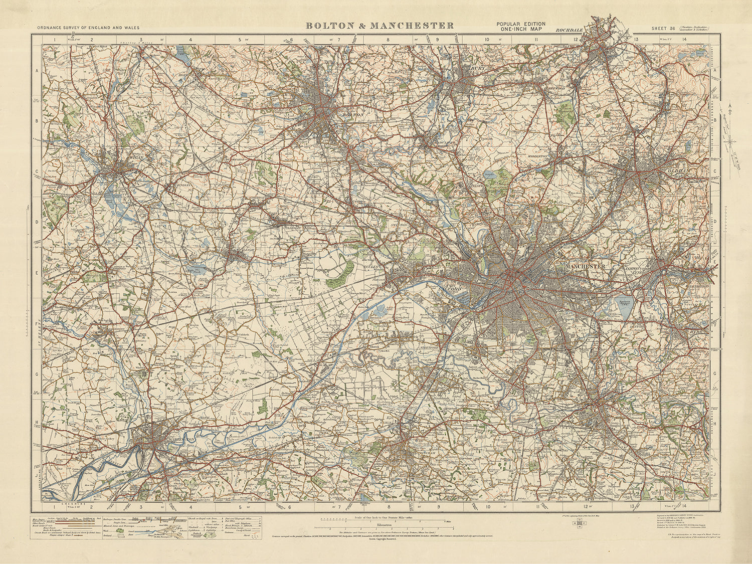


Old Ordnance Survey Map, Sheet 36: Bolton & Manchester, 1925: Warrington, Wigan, Oldham, Rochdale, Bury

-
![]() Handmade in the USA
Handmade in the USA
-
FREE worldwide delivery in 2-3 days ⓘ
Free delivery in 2-3 days
Your map should be delivered in 2-3 working days with free delivery, worldwide.
We make maps by hand locally in 23 countries. If you're buying a gift for someone in another country, we will make the map locally to them.
You will never pay import tax or customs duty.
Express delivery is available at checkout which can reduce the delivery time to 1-2 days.
Please note that personalised maps, and larger framed maps, can take longer to produce and deliver.
If you need your order to arrive by a certain date, contact me and we can discuss your options.
-
90 day money back guarantee ⓘ
90 days to return and refund
Products can be returned within 90 days for a full refund, or exchange for another product.
For personalised or custom made items, we may offer you a non-expiring gift card, as we cannot resell personalised orders.
If you have any questions, get in touch. For more information, see our full returns & exchanges policy.

My maps are rare, museum-grade, restored old maps sourced from libraries, auction houses and private collections across the globe.
Framing & free personalisation available
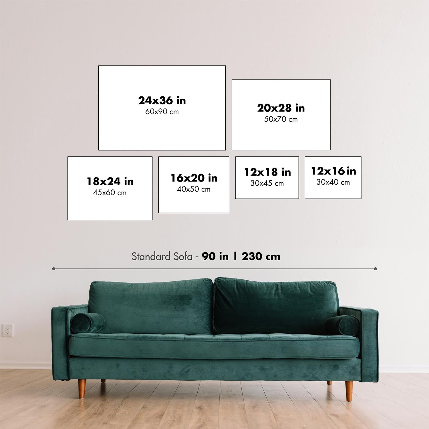
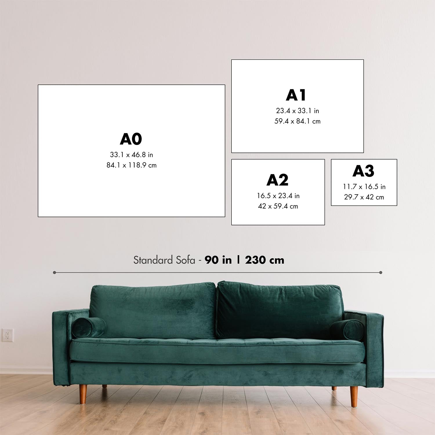
The best size for this map
If you have the space and the budget, I recommend buying a map that is 16x20 inches (40x50cm) or larger. Most maps look better at larger sizes because of the huge amount of detail on them.
When you buy the smallest size (usually 12in or 30cm), the text can be quite small. I recommend contacting me if you want to make sure that a map looks good at a specific size. I will usually respond within a few minutes.
Because all orders are handmade, every map can be made at a custom size. Please provide the custom size in the 'order notes' at checkout. Or contact me before you order.
Map size guide
To help you pick the right size, here are some of my 'standard' map sizes next to each other, in portrait and landscape orientation.

| 12x16in (30x40cm) | 16x20in (40x50cm) | 18x24in (45x60cm) |
24x36in (60x90cm) |

| 12x16in (30x40cm) | 16x20in (40x50cm) | 18x24in (45x60cm) |
24x36in (60x90cm) |
Buying unframed maps
If you buy an unframed old map from me, and plan to frame it yourself, please read this page for important information about framing your map.
General size guidelines
Generally, the size you see on the shop is exactly accurate.
So, for example, if you buy an 18x24 inch map, you should buy a frame that 'fits artwork' that is 18x24 inches. If you order a 60x90cm map, you should buy a frame that 'fits artwork' that is 60x90cm.
If you see a map that is an unusual size, such as 24x11 inches (or 61x29cm), I strongly recommend you wait for the map to arrive before making or ordering a frame online. These maps can vary in size by a few millimetres, and it's very frustrating if they don't fit into your frame!
If you need a map that is an exact size in centimetres or inches, please contact me.
Large maps
Please contact me if you are planning to frame a large map (over 40 inches or 100cm) yourself.
If you are buying your own frame, I recommend you wait for the frame to arrive, confirm the internal size of the frame, and then tell me the exact size that you need. Measure the width and height of the board on the back of the frame to get an accurate measurement.
Alternatively, buy the map from me, measure it when it arrives, and then order a frame to fit.
For large maps I can customise the size of your map for free.
If you are taking your map to a local framer, they will measure the map for you and then make the frame to fit.
1. Select your size
2. Customise your map
Personalise your map with framing, hand-drawn customisation, vintage ageing, pop art text, unique 3D styling and moreGift message & custom finish

If you want to add a gift message, or a finish (jigsaw, aluminium board, etc.) that is not available here, please request it in the "order note" when you check out.
Every order is custom made, so if you need the size adjusted slightly, or printed on an unusual material, just let us know. We've done thousands of custom orders over the years, so there's (almost) nothing we can't manage.
You can also contact us before you order, if you prefer!

- Handmade locally. No import duty or tax
- FREE Delivery. Arrives in 2-3 days
- Love it or your money back
- Questions? WhatsApp me any time
Own a piece of history
5,000+ 5 star reviews


The Old Ordnance Survey Map, Sheet 36 - Bolton & Manchester, 1925 is a remarkable piece of cartographic history that provides a fascinating glimpse into the past. This map, part of the One-inch "Popular" edition for England and Wales, showcases the towns of Bolton and Manchester, along with several other significant settlements and features in the surrounding area.
On this map, you will find the historic county of Lancashire, where both Bolton and Manchester are located. While exploring the intricately detailed contours and topographical features, it is important to note that some modern cities may not be depicted on this map. However, what makes this map truly captivating is the inclusion of earlier names for certain locations, allowing you to uncover the evolution of the region.
This map showcases several major settlements and features, each with its own historical significance:
- Bolton: A prominent industrial town known for its textile industry and rich history dating back to the 12th century.
- Manchester: A bustling city renowned for its role in the Industrial Revolution and its vibrant cultural heritage.
- Warrington: An ancient town with a strategic location on the banks of the River Mersey, known for its industrial and transport links.
- Wigan: A former coal mining and textile town, famous for its rugby league heritage and the iconic Wigan Pier.
- Oldham: A significant textile manufacturing center during the Industrial Revolution and home to notable cotton mills.
- Rochdale: A historic market town with a strong co-operative movement and a rich industrial heritage.
- Bury: Known for its traditional market and the famous Bury Market, which has been operating for over 500 years.
This map also highlights several boundaries, rivers, and natural features that add to its allure:
- River Mersey: A major river flowing through the region, connecting Manchester to the Irish Sea.
- Pennines: A range of hills and mountains that form a natural boundary between Lancashire and Yorkshire.
- West Pennine Moors: A beautiful expanse of moorland and reservoirs, offering stunning natural landscapes.
- Irwell Valley: A picturesque valley carved by the River Irwell, showcasing the region's natural beauty.
- Hollingworth Lake: A man-made lake nestled in the Pennines, popular for recreational activities and scenic walks.
This map provides insight into two significant historical events that occurred in the region, within two decades prior to 1925:
- Peterloo Massacre (1819): A tragic event in Manchester's history, where a peaceful protest demanding parliamentary reform turned violent, resulting in the deaths of several protesters.
- Lancashire Cotton Famine (1861-1865): A period of economic hardship caused by the American Civil War, leading to the disruption of cotton supplies and severe unemployment in the Lancashire cotton industry.
Embark on a captivating journey through time with the Old Ordnance Survey Map, Sheet 36 - Bolton & Manchester, 1925. Discover the rich heritage, explore the changing landscapes, and unravel the stories woven into the fabric of this remarkable region.
Please double check the images to make sure that a specific town or place is shown on this map. You can also get in touch and ask us to check the map for you.
This map looks great at all sizes: 12x16in (30.5x41cm), 18x24in (45.5x61cm), 16x20in (40.5x51cm), 24x36in (61x91.5cm), 30x40in (76x101.5cm), 37x50in (94x127cm), 45x60in (114x152.5cm) and 52x70in (132x178cm), but it looks even better when printed large.
I can create beautiful, large prints of this map up to 90in (229cm). Please get in touch if you're looking for larger, customised or different framing options.
The model in the listing images is holding the 18x24in (45.5x61cm) version of this map.
The fifth listing image shows an example of my map personalisation service.
The labels on this map are very small at 12x16in (30.5x41cm). The map is still very attractive, but you may struggle to read the smallest letters. Please buy a larger map if it's important to be able to read the map easily.
If you’re looking for something slightly different, check out my main collection of UK and Ireland maps.
Please contact me to check if a certain location, landmark or feature is shown on this map.
This would make a wonderful birthday, Christmas, Father's Day, work leaving, anniversary or housewarming gift for someone from the areas covered by this map.
This map is available as a giclée print on acid free archival matte paper, or you can buy it framed. The frame is a nice, simple black frame that suits most aesthetics. Please get in touch if you'd like a different frame colour or material. My frames are glazed with super-clear museum-grade acrylic (perspex/acrylite), which is significantly less reflective than glass, safer, and will always arrive in perfect condition.
This map is also available as a float framed canvas, sometimes known as a shadow gap framed canvas or canvas floater. The map is printed on artist's cotton canvas and then stretched over a handmade box frame. We then "float" the canvas inside a wooden frame, which is available in a range of colours (black, dark brown, oak, antique gold and white). This is a wonderful way to present a map without glazing in front. See some examples of float framed canvas maps and explore the differences between my different finishes.
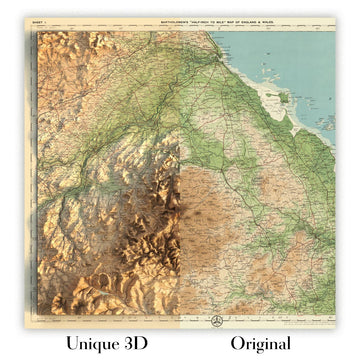
For something truly unique, this map is also available in "Unique 3D", our trademarked process that dramatically transforms the map so that it has a wonderful sense of depth. We combine the original map with detailed topography and elevation data, so that mountains and the terrain really "pop". For more info and examples of 3D maps, check my Unique 3D page.
For most orders, delivery time is about 3 working days. Personalised and customised products take longer, as I have to do the personalisation and send it to you for approval, which usually takes 1 or 2 days.
Please note that very large framed orders usually take longer to make and deliver.
If you need your order to arrive by a certain date, please contact me before you order so that we can find the best way of making sure you get your order in time.
I print and frame maps and artwork in 23 countries around the world. This means your order will be made locally, which cuts down on delivery time and ensures that it won't be damaged during delivery. You'll never pay customs or import duty, and we'll put less CO2 into the air.
All of my maps and art prints are well packaged and sent in a rugged tube if unframed, or surrounded by foam if framed.
I try to send out all orders within 1 or 2 days of receiving your order, though some products (like face masks, mugs and tote bags) can take longer to make.
If you select Express Delivery at checkout your order we will prioritise your order and send it out by 1-day courier (Fedex, DHL, UPS, Parcelforce).
Next Day delivery is also available in some countries (US, UK, Singapore, UAE) but please try to order early in the day so that we can get it sent out on time.
My standard frame is a gallery style black ash hardwood frame. It is simple and quite modern looking. My standard frame is around 20mm (0.8in) wide.
I use super-clear acrylic (perspex/acrylite) for the frame glass. It's lighter and safer than glass - and it looks better, as the reflectivity is lower.
Six standard frame colours are available for free (black, dark brown, dark grey, oak, white and antique gold). Custom framing and mounting/matting is available if you're looking for something else.
Most maps, art and illustrations are also available as a framed canvas. We use matte (not shiny) cotton canvas, stretch it over a sustainably sourced box wood frame, and then 'float' the piece within a wood frame. The end result is quite beautiful, and there's no glazing to get in the way.
All frames are provided "ready to hang", with either a string or brackets on the back. Very large frames will have heavy duty hanging plates and/or a mounting baton. If you have any questions, please get in touch.
See some examples of my framed maps and framed canvas maps.
Alternatively, I can also supply old maps and artwork on canvas, foam board, cotton rag and other materials.
If you want to frame your map or artwork yourself, please read my size guide first.
Alcune delle mie vecchie mappe sono ora disponibili come tele incorniciate. Per favore contattami se desideri ordinare una dimensione che non è disponibile nel mio negozio.
Le vecchie mappe su tela sono un'alternativa interessante alle mappe incorniciate in modo convenzionale. A seconda del tuo gusto personale e dell'arredamento della stanza, le mappe su tela possono "risaltare" un po' di più rispetto a una mappa incorniciata.
My maps are extremely high quality reproductions of original maps.
I source original, rare maps from libraries, auction houses and private collections around the world, restore them at my London workshop, and then use specialist giclée inks and printers to create beautiful maps that look even better than the original.
My maps are printed on acid-free archival matte (not glossy) paper that feels very high quality and almost like card. In technical terms the paper weight/thickness is 10mil/200gsm. It's perfect for framing.
I print with Epson ultrachrome giclée UV fade resistant pigment inks - some of the best inks you can find.
I can also make maps on canvas, cotton rag and other exotic materials.
Learn more about The Unique Maps Co.
Map personalisation
If you're looking for the perfect anniversary or housewarming gift, I can personalise your map to make it truly unique. For example, I can add a short message, or highlight an important location, or add your family's coat of arms.
The options are almost infinite. Please see my map personalisation page for some wonderful examples of what's possible.
To order a personalised map, select "personalise your map" before adding it to your basket.
Get in touch if you're looking for more complex customisations and personalisations.
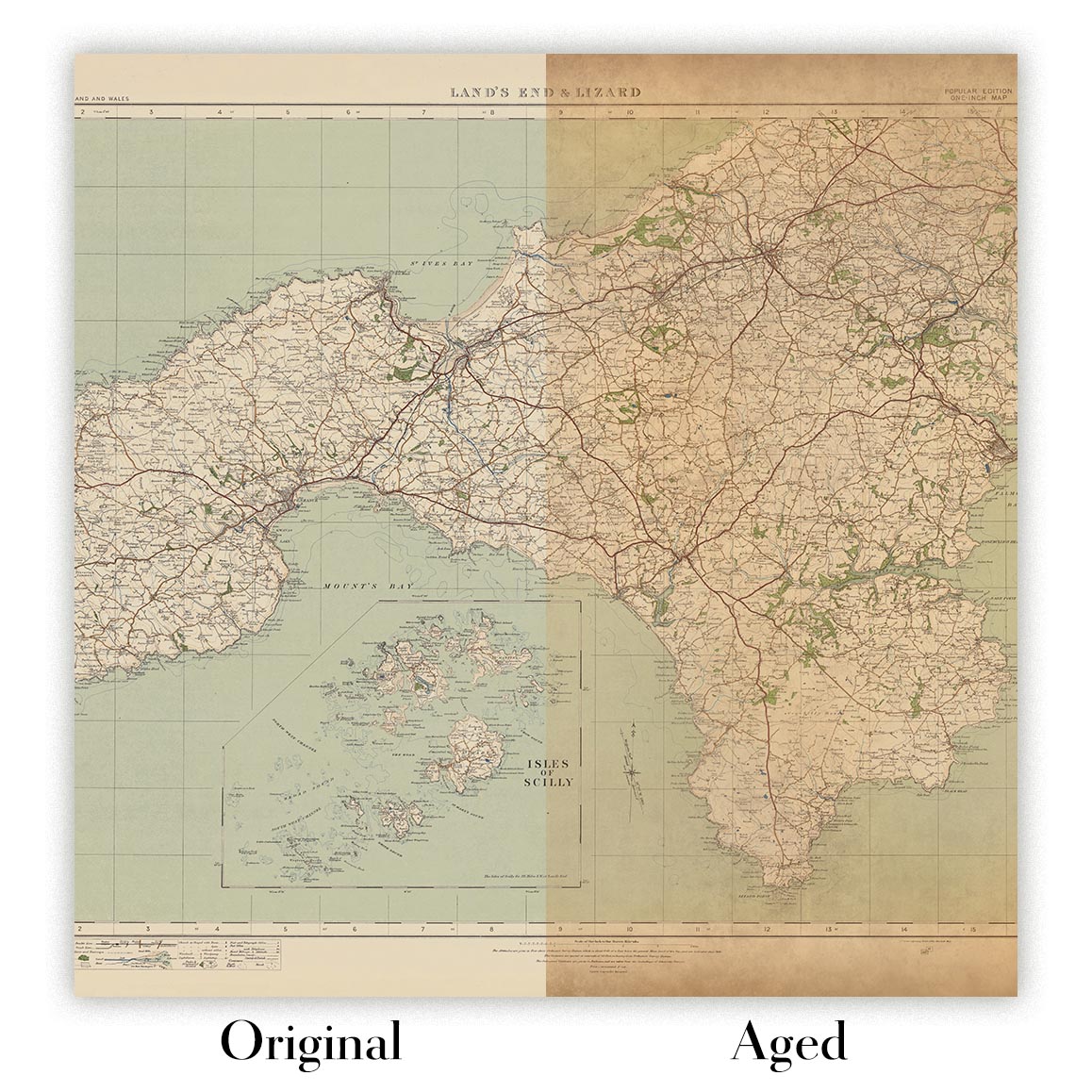
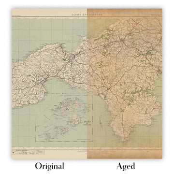
Map ageing
I have been asked hundreds of times over the years by customers if they could buy a map that looks even older.
Well, now you can, by selecting Aged before you add a map to your basket.
All the product photos you see on this page show the map in its Original form. This is what the map looks like today.
If you select Aged, I will age your map by hand, using a special and unique process developed through years of studying old maps, talking to researchers to understand the chemistry of aging paper, and of course... lots of practice!
If you're unsure, stick to the Original colour of the map. If you want something a bit darker and older looking, go for Aged.
Se non sei soddisfatto del tuo ordine per qualsiasi motivo, contattami per un rimborso senza problemi. Si prega di consultare la nostra politica di reso e rimborso per ulteriori informazioni.
Sono molto sicuro che ti piacerà la tua mappa restaurata o la stampa d'arte. Lo faccio dal 1984. Sono un venditore Etsy a 5 stelle. Ho venduto decine di migliaia di mappe e stampe d'arte e ho oltre 5.000 recensioni reali a 5 stelle.
Utilizzo un processo unico per restaurare mappe e opere d'arte che richiede molto tempo e lavoro. Trovare le mappe e le illustrazioni originali può richiedere mesi. Utilizzo tecnologia all'avanguardia e incredibilmente costosa per scannerizzare e restaurarle. Di conseguenza, garantisco che le mie mappe e stampe d'arte siano superiori alle altre - ecco perché posso offrire un rimborso senza problemi.
Quasi tutte le mie mappe e stampe d'arte sembrano fantastiche a grandi dimensioni (200 cm, 6,5 piedi+) e posso anche incorniciarle e consegnarle a te, tramite un corriere speciale per oggetti di grandi dimensioni. Contattami per discutere delle tue esigenze specifiche.
Or try searching for something!


