


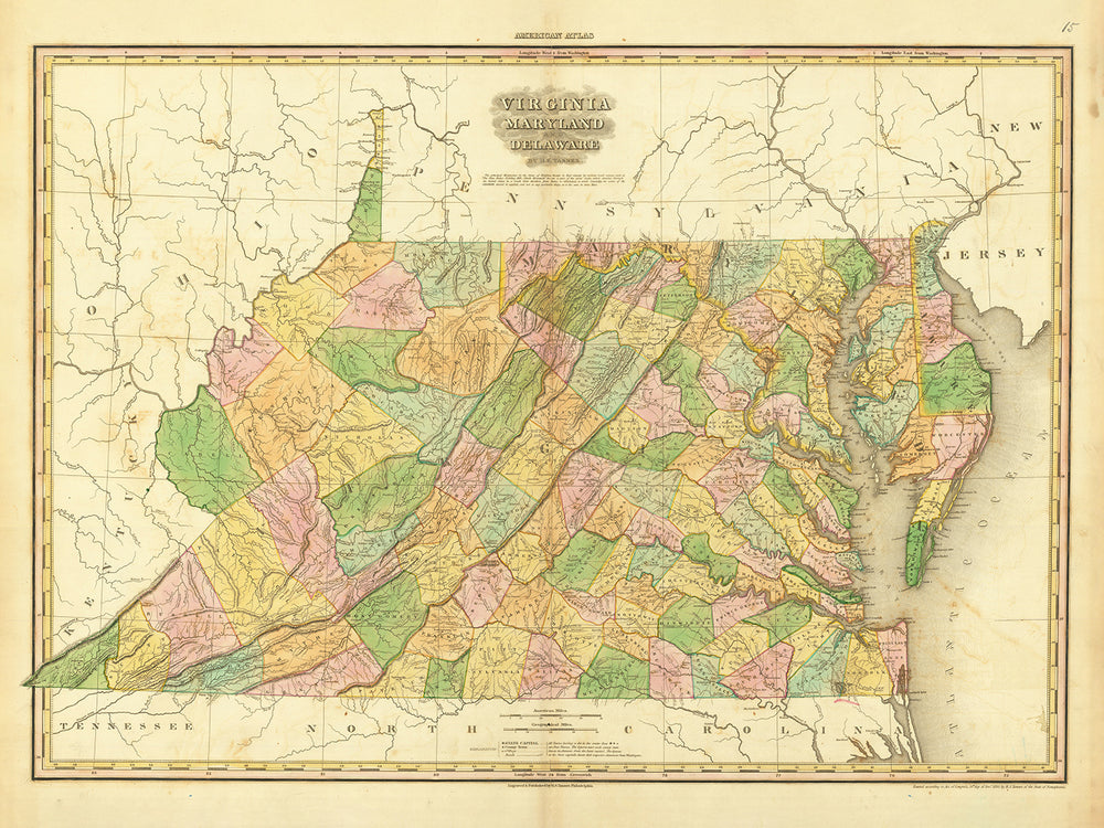


Antica mappa della Virginia, Delaware, Maryland e Washington D.C. di H. S. Tanner (1820): Con Baltimore, Alexandria, Norfolk, Richmond e Wilmington
Compra 2, Ricevi 1 Gratuito
Se aggiungi 2 articoli al tuo carrello, puoi aggiungere un terzo prodotto gratuitamente.
Questo vale per tutte le mappe e opere d'arte, comprese le opere personalizzate e su misura. Puoi ordinare 3 dello stesso articolo, o 3 articoli diversi.
Questo equivale a uno sconto del 33%, che sarà il maggiore sconto disponibile nel mio negozio quest'anno.
Ti prego di approfittare dell'offerta e di coprire le tue pareti con bellissime mappe e opere d'arte!
Contattami se hai domande.
-
![]() Handmade in the USA
Handmade in the USA

-
FREE worldwide delivery in 2-3 days ⓘ
Free delivery in 2-3 days
Your map should be delivered in 2-3 working days with free delivery, worldwide.
We make maps by hand locally in 23 countries. If you're buying a gift for someone in another country, we will make the map locally to them.
You will never pay import tax or customs duty.
Express delivery is available at checkout which can reduce the delivery time to 1-2 days.
Please note that personalised maps, and larger framed maps, can take longer to produce and deliver.
If you need your order to arrive by a certain date, contact me and we can discuss your options.
-
Complimentary gifting & design advice
ⓘ
Complimentary gifting & design advice
Available almost 24/7 on WhatsApp and email — we usually reply within minutes. We can help you:
- Choose a perfectly personalised gift
- Send a digital gift preview to the recipient
- Pick the ideal size for your wall
- Select the right finish and frame
Quick, friendly advice so you can order with confidence.
For last minute gifts, consider buying a digital gift card. We have over 5,000 maps and art prints to choose from.
-
90-day returns & 5-year guarantee
ⓘ
90 giorni per restituire e ricevere un rimborso
I prodotti possono essere restituiti entro 90 giorni per un rimborso completo, o cambio con un altro prodotto.
Per articoli personalizzati e su misura, potremmo offrirti un credito in negozio o una carta regalo non scadente, poiché non possiamo rivendere ordini personalizzati.
Se hai domande, contattaci. Per ulteriori informazioni, consulta la nostra politica di restituzione e cambio.

This is a museum-grade archival print from the original 1820 map — restored in our workshop and made to order on 220gsm archival matte paper or 400gsm artist's cotton canvas with pigment inks.
Professional framing & free personalisation available
1. Select your size
Click here to order a custom size.
2. Frame & personalize your map
Make your map unique with framing, hand-drawn customisation, vintage ageing, pop art text, unique 3D styling and more.


Gift message & custom finish

If you want to add a gift message, or a finish (jigsaw, aluminium board, etc.) that is not available here, please request it in the "order note" when you check out.
Every order is custom made, so if you need the size adjusted slightly, or printed on an unusual material, just let us know. We've done thousands of custom orders over the years, so there's (almost) nothing we can't manage.
You can also contact us before you order, if you prefer!

- Handmade locally. No import duty or tax
- FREE worldwide delivery
- 90-day returns & 5-year product guarantee
- Questions? WhatsApp me any time
Own a piece of history
7,000+ 5 star reviews


Presentiamo un pezzo squisito di storia cartografica, la Mappa Antica della Virginia, Delaware e Maryland di H. S. Tanner, pubblicata nel 1820. Questa mappa meticolosamente realizzata mostra i confini territoriali e i dettagli topografici di questi tre stati durante un'epoca cruciale nella storia americana. Con le sue delicate incisioni e le intricate tecniche cartografiche, questa mappa funge da straordinaria finestra sul passato, trasportandoti in un'epoca in cui questi insediamenti e colonie stavano facendo i loro primi passi verso la formazione del futuro degli Stati Uniti. Immergiti nel ricco patrimonio di questa regione mentre esplori le seguenti città, contee, insediamenti e colonie notevoli fondate prima del 1820:
Questa mappa include anche Washington D.C., che era stata fondata 30 anni prima, nel 1790.
Gli insediamenti su questa mappa includono...
Virginia:
- Alexandria (1749): Fondata come una grande città portuale lungo il fiume Potomac, Alexandria ha svolto un ruolo significativo nella storia coloniale e americana, servendo come un vitale centro commerciale e un importante centro di cultura e apprendimento.
- Norfolk (1682): Stabilita come una prospera città portuale, Norfolk è diventata un importante centro marittimo e commerciale nella regione, attirando coloni di vari provenienze.
- Richmond (1737): Crescendo come capitale della Virginia, Richmond è cresciuta rapidamente grazie alla sua posizione strategica lungo il fiume James, diventando una potenza economica e successivamente una città critica durante la Guerra Civile.
- Petersburg (1748): Nota per la sua posizione strategica sul fiume Appomattox, Petersburg si è evoluta in un vivace centro di produzione e trasporti, facilitando il commercio tra la costa e l'interno.
- Fredericksburg (1728): Fondata lungo il fiume Rappahannock, Fredericksburg ha assistito a eventi notevoli durante la Rivoluzione Americana e la Guerra Civile, preservando il suo fascino storico.
Delaware:
- Wilmington (1731): Fondata come una fiorente città portuale lungo il fiume Delaware, Wilmington è cresciuta in un centro industriale e finanziario, contribuendo alla prominenza del Delaware nel commercio e nel commercio.
- New Castle (1651): Fondata dagli olandesi, New Castle ha servito come un insediamento coloniale influente e un vitale avamposto commerciale, lasciando un impatto duraturo sulla storia e la cultura del Delaware.
- Dover (1683): Scelta come capitale del Delaware, Dover è emersa come un centro politico e amministrativo, ospitando importanti istituzioni governative e incarnando il patrimonio dello stato.
- Lewes (1631): Uno dei primi insediamenti europei nella regione, Lewes vanta una ricca storia e un fascino pittoresco, caratterizzato da monumenti storici e una profonda connessione con le tradizioni marittime del Delaware.
- Milford (1787): Fondata lungo il fiume Mispillion, Milford si è sviluppata in una fiorente città agricola e manifatturiera, giocando un ruolo nella crescita economica del Delaware.
Maryland:
- Baltimore (1729): Fondata come una vivace città portuale sul fiume Patapsco, Baltimore è cresciuta rapidamente in un importante centro industriale e culturale, rinomata per il suo vivace porto, architettura e significato storico.
- Annapolis (1649): Selezionata come capitale del Maryland, Annapolis è diventata un punto focale della vita politica e culturale dello stato, nota per il suo fascino coloniale e il suo status di meta per la vela.
- Frederick (1745): Situata ai piedi delle Montagne Appalache, Frederick si è evoluta in una vivace città di mercato, riflettendo il patrimonio agricolo e commerciale del Maryland.
- Hagerstown (1762): Stabilita vicino ai crocevia di importanti rotte commerciali, Hagerstown prosperò come centro di commercio e trasporti, incarnando lo spirito dell'espansione verso ovest.
- Salisbury (1732): Situata lungo il fiume Wicomico, Salisbury si sviluppò in un fiorente centro commerciale e agricolo, con un centro vivace e un forte senso di comunità.
Oltre a questi insediamenti storici, questa mappa straordinaria mette in mostra caratteristiche naturali e confini notevoli che hanno svolto un ruolo nella formazione dello sviluppo della regione. Esplora i sentieri tortuosi della Baia di Chesapeake, segui il corso dei fiumi Potomac e James, e scopri i primi territori delle tribù dei nativi americani. Acquisisci una maggiore apprezzamento per la bellezza naturale e il patrimonio culturale della regione.
Inoltre, tra il 1810 e il 1830, questa regione ha assistito a eventi storici significativi che hanno plasmato il corso della storia americana. Alcuni eventi notevoli durante questo periodo includono la Guerra del 1812 e il successivo incendio di Washington, D.C., il Compromesso del Missouri del 1820, che mirava a affrontare la questione dell'espansione della schiavitù, e la costruzione del Canale Chesapeake e Ohio, un'impresa ingegneristica innovativa.
Questa Vecchia Mappa della Virginia, Delaware e Maryland di H. S. Tanner, pubblicata nel 1820, è un artefatto prezioso che offre uno sguardo affascinante nel passato. Che tu sia un appassionato di storia, un intenditore di cartografia o qualcuno in cerca di un pezzo decorativo unico, questa mappa arricchirà senza dubbio la tua comprensione dell'eredità storica di questa regione e servirà come spunto di conversazione per le generazioni a venire.
Si prega di controllare le immagini per assicurarsi che una specifica città o luogo sia mostrato su questa mappa. Puoi anche contattarci e chiedere di controllare la mappa per te.
Questa mappa appare fantastica in tutte le dimensioni: 12x16in (30.5x41cm), 18x24in (45.5x61cm), 16x20in (40.5x51cm), 24x36in (61x91.5cm), 30x40in (76x101.5cm), 37x50in (94x127cm), 45x60in (114x152.5cm) e 52x70in (132x178cm), ma appare ancora meglio quando stampata in grande.
Posso creare bellissime stampe grandi di questa mappa fino a 100in (254cm). Ti preghiamo di contattarci se stai cercando opzioni di incorniciatura più grandi, personalizzate o diverse.
Il modello nelle immagini dell'elenco tiene in mano la versione 18x24in (45.5x61cm) di questa mappa.
La quinta immagine dell'elenco mostra un esempio del mio servizio di personalizzazione delle mappe.
Se stai cercando qualcosa di leggermente diverso, dai un'occhiata alla mia principale collezione di mappe degli Stati Uniti e del Nord America.
Si prega di contattarmi per verificare se un certo luogo, punto di riferimento o caratteristica è mostrato su questa mappa.
Questo sarebbe un meraviglioso regalo di compleanno, Natale, Festa del Papà, partenza dal lavoro, anniversario o inaugurazione per qualcuno delle aree coperte da questa mappa.
Questa mappa è disponibile come stampa giclée su carta opaca archiviabile senza acidi, oppure puoi acquistarla incorniciata. La cornice è una bella e semplice cornice nera che si adatta alla maggior parte degli stili. Ti preghiamo di contattarci se desideri un colore o un materiale di cornice diverso. Le mie cornici sono dotate di un vetro acrilico super chiaro di qualità museale (perspex/acrylite), che è significativamente meno riflettente del vetro, più sicuro e arriverà sempre in perfette condizioni.
This map is also available as a float framed canvas, sometimes known as a shadow gap framed canvas or canvas floater. The map is printed on artist's cotton canvas and then stretched over a handmade box frame. We then "float" the canvas inside a wooden frame, which is available in a range of colours (black, dark brown, oak, antique gold and white). This is a wonderful way to present a map without glazing in front. See some examples of float framed canvas maps and explore the differences between my different finishes.
For something truly unique, this map is also available in "Unique 3D", our trademarked process that dramatically transforms the map so that it has a wonderful sense of depth. We combine the original map with detailed topography and elevation data, so that mountains and the terrain really "pop". For more info and examples of 3D maps, check my Unique 3D page.
For most orders, delivery time is about 3 working days. Personalised and customised products take longer, as I have to do the personalisation and send it to you for approval, which usually takes 1 or 2 days.
Please note that very large framed orders usually take longer to make and deliver.
If you need your order to arrive by a certain date, please contact me before you order so that we can find the best way of making sure you get your order in time.
I print and frame maps and artwork in 23 countries around the world. This means your order will be made locally, which cuts down on delivery time and ensures that it won't be damaged during delivery. You'll never pay customs or import duty, and we'll put less CO2 into the air.
All of my maps and art prints are well packaged and sent in a rugged tube if unframed, or surrounded by foam if framed.
I try to send out all orders within 1 or 2 days of receiving your order, though some products (like face masks, mugs and tote bags) can take longer to make.
If you select Express Delivery at checkout your order we will prioritise your order and send it out by 1-day courier (Fedex, DHL, UPS, Parcelforce).
Next Day delivery is also available in some countries (US, UK, Singapore, UAE) but please try to order early in the day so that we can get it sent out on time.
My standard frame is a gallery style black ash hardwood frame. It is simple and quite modern looking. My standard frame is around 20mm (0.8in) wide.
I use super-clear acrylic (perspex/acrylite) for the frame glass. It's lighter and safer than glass - and it looks better, as the reflectivity is lower.
Six standard frame colours are available for free (black, dark brown, dark grey, oak, white and antique gold). Custom framing and mounting/matting is available if you're looking for something else.
Most maps, art and illustrations are also available as a framed canvas. We use matte (not shiny) cotton canvas, stretch it over a sustainably sourced box wood frame, and then 'float' the piece within a wood frame. The end result is quite beautiful, and there's no glazing to get in the way.
All frames are provided "ready to hang", with either a string or brackets on the back. Very large frames will have heavy duty hanging plates and/or a mounting baton. If you have any questions, please get in touch.
See some examples of my framed maps and framed canvas maps.
Alternatively, I can also supply old maps and artwork on canvas, foam board, cotton rag and other materials.
If you want to frame your map or artwork yourself, please read my size guide first.
Alcune delle mie vecchie mappe sono ora disponibili come tele incorniciate. Per favore contattami se desideri ordinare una dimensione che non è disponibile nel mio negozio.
Le vecchie mappe su tela sono un'alternativa interessante alle mappe incorniciate in modo convenzionale. A seconda del tuo gusto personale e dell'arredamento della stanza, le mappe su tela possono "risaltare" un po' di più rispetto a una mappa incorniciata.
My maps are extremely high quality reproductions of original maps.
I source original, rare maps from libraries, auction houses and private collections around the world, restore them at my London workshop, and then use specialist giclée inks and printers to create beautiful maps that look even better than the original.
My maps are printed on acid-free archival matte (not glossy) paper that feels very high quality and almost like card. In technical terms the paper weight/thickness is 10mil/200gsm. It's perfect for framing.
I print with Epson ultrachrome giclée UV fade resistant pigment inks - some of the best inks you can find.
I can also make maps on canvas, cotton rag and other exotic materials.
Learn more about The Unique Maps Co.
Map personalisation
If you're looking for the perfect anniversary or housewarming gift, I can personalise your map to make it truly unique. For example, I can add a short message, or highlight an important location, or add your family's coat of arms.
The options are almost infinite. Please see my map personalisation page for some wonderful examples of what's possible.
To order a personalised map, select "personalise your map" before adding it to your basket.
Get in touch if you're looking for more complex customisations and personalisations.
Map ageing
I have been asked hundreds of times over the years by customers if they could buy a map that looks even older.
Well, now you can, by selecting Aged before you add a map to your basket.
All the product photos you see on this page show the map in its Original form. This is what the map looks like today.
If you select Aged, I will age your map by hand, using a special and unique process developed through years of studying old maps, talking to researchers to understand the chemistry of aging paper, and of course... lots of practice!
If you're unsure, stick to the Original colour of the map. If you want something a bit darker and older looking, go for Aged.
Se non sei soddisfatto del tuo ordine per qualsiasi motivo, contattami per un rimborso senza problemi. Si prega di consultare la nostra politica di reso e rimborso per ulteriori informazioni.
Sono molto sicuro che ti piacerà la tua mappa restaurata o la stampa d'arte. Lo faccio dal 1984. Sono un venditore Etsy a 5 stelle. Ho venduto decine di migliaia di mappe e stampe d'arte e ho oltre 5.000 recensioni reali a 5 stelle.
Utilizzo un processo unico per restaurare mappe e opere d'arte che richiede molto tempo e lavoro. Trovare le mappe e le illustrazioni originali può richiedere mesi. Utilizzo tecnologia all'avanguardia e incredibilmente costosa per scannerizzare e restaurarle. Di conseguenza, garantisco che le mie mappe e stampe d'arte siano superiori alle altre - ecco perché posso offrire un rimborso senza problemi.
Quasi tutte le mie mappe e stampe d'arte sembrano fantastiche a grandi dimensioni (200 cm, 6,5 piedi+) e posso anche incorniciarle e consegnarle a te, tramite un corriere speciale per oggetti di grandi dimensioni. Contattami per discutere delle tue esigenze specifiche.
Or try searching for something!


