


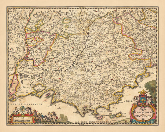


Antica mappa della Provenza, Francia di Visscher, 1690: Marsiglia, Avignone, Cannes, Nizza, Parco Nazionale delle Calanques
20% di sconto su 2 — 33% di sconto su 3
Aggiungi qualsiasi due articoli idonei al tuo carrello per ricevere 20% di sconto. Aggiungi un terzo e sarà gratuito (equivalente a 33% di sconto quando acquisti tre).
Nessun codice necessario — l'offerta si applica automaticamente al checkout.
Valido su tutte le mappe standard e le stampe d'arte fine. Puoi mescolare e abbinare qualsiasi design.
Se desideri spedire articoli a più indirizzi, ti preghiamo di contattarci prima di effettuare il tuo ordine.
Le commissioni personalizzate e su misura sono escluse.
Contattaci se hai domande
-
![]() Handmade in the USA
Handmade in the USA

-
FREE worldwide delivery in 2-3 days ⓘ
Free delivery in 2-3 days
Your map should be delivered in 2-3 working days with free delivery, worldwide.
We make maps by hand locally in 23 countries. If you're buying a gift for someone in another country, we will make the map locally to them.
You will never pay import tax or customs duty.
Express delivery is available at checkout which can reduce the delivery time to 1-2 days.
Please note that personalised maps, and larger framed maps, can take longer to produce and deliver.
If you need your order to arrive by a certain date, contact me and we can discuss your options.
-
Complimentary gifting & design advice
ⓘ
Complimentary gifting & design advice
Available almost 24/7 on WhatsApp and email — we usually reply within minutes. We can help you:
- Choose a perfectly personalised gift
- Send a digital gift preview to the recipient
- Pick the ideal size for your wall
- Select the right finish and frame
Quick, friendly advice so you can order with confidence.
For last minute gifts, consider buying a digital gift card. We have over 5,000 maps and art prints to choose from.
-
90-day returns & 5-year guarantee
ⓘ
90 giorni per restituire e ricevere un rimborso
I prodotti possono essere restituiti entro 90 giorni per un rimborso completo, o cambio con un altro prodotto.
Per articoli personalizzati e su misura, potremmo offrirti un credito in negozio o una carta regalo non scadente, poiché non possiamo rivendere ordini personalizzati.
Se hai domande, contattaci. Per ulteriori informazioni, consulta la nostra politica di restituzione e cambio.

This is a museum-grade archival print from the original 1690 map — restored in our workshop and made to order on 220gsm archival matte paper or 400gsm artist's cotton canvas with pigment inks.
Professional framing & free personalisation available.
1. Choose a size
2. Frame & personalize your map
Make your map unique with framing, hand-drawn customisation, vintage ageing, pop art text, unique 3D styling and more.


Gift message & custom finish

If you want to add a gift message, or a finish (jigsaw, aluminium board, etc.) that is not available here, please request it in the "order note" when you check out.
Every order is custom made, so if you need the size adjusted slightly, or printed on an unusual material, just let us know. We've done thousands of custom orders over the years, so there's (almost) nothing we can't manage.
You can also contact us before you order, if you prefer!

- Handmade locally. No import duty or tax
- FREE worldwide delivery
- 90-day returns & 5-year product guarantee
- Questions? WhatsApp me any time
Own a piece of history
7,000+ 5 star reviews


Immergiti nella ricca storia e nella geografia mozzafiato della Francia con l'esclusiva mappa 'Comte et gouvernement de Provence'. Realizzata da Nicolaes Visscher II nel 1690, questo capolavoro della cartografia è una testimonianza della grandezza dell'età dell'oro olandese. La mappa, il cui nome si traduce in 'Contea e Governo di Provenza', illustra in modo intricato le divisioni politiche e le regioni della Provincia di Provenza in quella che oggi è la Francia moderna. L'incisione dettagliata, combinata con la colorazione a mano in contorno, dà vita alla vibrante cultura e al paesaggio diversificato di questa affascinante regione.
La mappa è un tesoro di città e luoghi che hanno plasmato la storia e l'identità della Provenza. La vivace città portuale di Marsiglia, la città papale di Avignone, la glamour Cannes, la soleggiata Nizza e il sorprendente Parc national des Calanques (Parco Nazionale delle Calanques) sono tutti rappresentati magnificamente. Ogni città e luogo non è solo un punto sulla mappa, ma una storia che aspetta di essere scoperta, un viaggio che aspetta di essere intrapreso.
Oltre alle città e ai luoghi, la mappa mostra anche la bellezza naturale e la diversità geografica della regione. Le incisioni intricate raffigurano foreste, corsi d'acqua, canali e montagne, offrendo uno sguardo sulla ricca biodiversità della regione. Il rilievo mostrato in modo pittorico aumenta ulteriormente l'appeal visivo della mappa, rendendola un pezzo d'arte affascinante. I cartigli decorativi e gli stemmi aggiungono un elemento di regalità, sottolineando il significato storico della mappa.
Questa mappa è più di una semplice rappresentazione dei confini geografici e politici; è una finestra sul passato, un riflesso dell'evoluzione storica e culturale della Provenza. Che tu sia un appassionato di storia, un amante dell'arte o un intenditore di lusso, la mappa 'Comte et gouvernement de Provence' è un pezzo unico che aggiungerà un tocco di eleganza e sofisticatezza alla tua collezione. Non è solo una mappa, ma una testimonianza del fascino duraturo della Provenza, una regione che continua a catturare e ispirare.
Alcuni dei luoghi significativi mostrati su questa mappa:
Città nella Provincia di Provenza
- Marsiglia - Conosciuta come Massalia in tempi antichi, è la città più antica della Francia, fondata dai Focesi nel 600 a.C. È diventata un importante porto commerciale nel Mediterraneo.
- Nizza - Conosciuta come Nicaea in tempi antichi, è stata fondata dai Greci di Massalia ed era un importante avamposto commerciale.
- Avignone - Conosciuta come Avenio in epoca romana, è stata la sede del Papato nel XIV secolo.
- Tolone - Nota per il suo porto strategico, è diventata un importante centro per la costruzione navale nel XVII secolo.
- Aix-en-Provence - Conosciuta come Aquae Sextiae in epoca romana, era la capitale della Provenza nel XV secolo.
- Arles - Conosciuta come Arelate in tempi antichi, era una città importante nell'Impero Romano.
- Fréjus - Conosciuta come Forum Julii in epoca romana, era una base militare e un porto importante.
- Antibes - Conosciuta come Antipolis in tempi antichi, era una colonia greca.
- Cannes - Conosciuta per il suo Festival del Cinema annuale in tempi moderni, era un piccolo villaggio di pescatori nel XVII secolo.
- Draguignan - È stata la sede della Sottoprefettura del dipartimento del Var fino al 1974.
- Hyères - Conosciuta come Olbia in tempi antichi, era una colonia greca.
- Grasse - Conosciuta per la sua industria della profumeria ben consolidata.
- Cavaillon - Conosciuta come Cabellio in epoca romana.
- Manosque - Era un importante centro commerciale nel Medioevo.
- Digne - Conosciuta come Dinia in epoca romana, era la capitale della famiglia Briançonnet nel XIV secolo.
- Gap - Era un importante centro della Riforma nel XVI secolo.
- Sisteron - Conosciuta per la sua posizione strategica sulla Route di Napoleone.
- Orange - Conosciuta come Arausio in tempi antichi, ospita un teatro romano ben conservato.
- Carpentras - Era la capitale del Comtat Venaissin, un territorio papale.
- Martigues - Conosciuta come Maritima Avaticorum in epoca romana.
- Salon-de-Provence - Conosciuta per la sua fortezza medievale e la casa di Nostradamus.
- Istres - Era un importante centro di produzione di ceramiche nell'Impero Romano.
- La Ciotat - Conosciuta per la sua industria cantieristica.
- Miramas - Era un importante hub per il trasporto ferroviario.
- Gardanne - Conosciuta per la sua industria mineraria del carbone.
- Aubagne - Conosciuta per la sua industria di ceramiche e terracotta.
- Les Pennes-Mirabeau - Era un villaggio fortificato medievale.
- Vitrolles - Conosciuta per il suo plateau roccioso e l'architettura medievale.
- Marignane - Conosciuta per i suoi vigneti e oliveti.
- La Seyne-sur-Mer - Conosciuta per la sua industria cantieristica.
Fenomeni Naturali Notabili
- Fiume Rodano - Uno dei fiumi principali in Europa, sfocia nel Mar Mediterraneo.
- Parco Nazionale delle Calanques - Un parco nazionale situato tra Marsiglia e Cassis, noto per le sue spettacolari scogliere di calcare e acque turchesi.
- Mont Ventoux - Conosciuto come il "Gigante della Provenza", è una meta popolare per i ciclisti.
- Gola del Verdon - Conosciuta come il "Grand Canyon d'Europa", è una meta popolare per escursioni e sport acquatici.
- Luberon - Un massiccio nella Provenza centrale, noto per i suoi pittoreschi villaggi e la sua flora e fauna diversificate.
Eventi Storici (1600-1690)
- Assedio di Tolone (1707) - Nell'ambito della Guerra di Successione Spagnola, le forze britanniche assediarono Tolone.
- Fondazione dell'Accademia Francese a Roma (1666) - Il re Luigi XIV fondò l'Accademia Francese a Roma. Molti artisti provenienti dalla Provenza vi studiarono.
- Costruzione del Canale di Marsiglia (1666-1849) - Questo canale fu costruito per portare acqua dal fiume Durance a Marsiglia.
Si prega di controllare le immagini per assicurarsi che una specifica città o luogo sia mostrato su questa mappa. Puoi anche contattarci e chiedere di controllare la mappa per te.
Questa mappa è fantastica in tutte le dimensioni: 12x16in (30.5x41cm), 16x20in (40.5x51cm), 18x24in (45.5x61cm), 24x30in (61x76cm), 32x40in (81.5x102cm), 40x50in (102x127cm), 48x60in (122x153cm) e 56x70in (142x178cm), ma sembra ancora meglio quando stampata in grande.
Posso creare stampe belle e grandi di questa mappa fino a 90 pollici (229 cm). Ti prego di contattarmi se stai cercando opzioni di incorniciatura più grandi, personalizzate o diverse.
Il modello nelle immagini dell'annuncio tiene la versione di questa mappa di 16x20 pollici (40.5x51 cm).
La quinta immagine dell'annuncio mostra un esempio del mio servizio di personalizzazione della mappa.
Se stai cercando qualcosa di leggermente diverso, dai un'occhiata alla mia collezione delle migliori vecchie mappe d'Europa e delle città europee per vedere se qualcosa attira la tua attenzione.
Ti prego di contattarmi per verificare se una certa posizione, un punto di riferimento o una caratteristica è mostrata su questa mappa.
Questo sarebbe un meraviglioso regalo di compleanno, Natale, Festa del Papà, addio al lavoro, anniversario o per una festa di inaugurazione per qualcuno delle aree coperte da questa mappa.
Questa mappa è disponibile come stampa giclée su carta opaca archivistica senza acidi, oppure puoi acquistarla incorniciata. La cornice è una semplice cornice nera che si adatta alla maggior parte degli stili. Ti prego di contattarmi se desideri un colore o un materiale di cornice diverso. Le mie cornici sono dotate di vetro acrilico museale super chiaro (perspex/acrylite), che è significativamente meno riflettente del vetro, più sicuro e arriverà sempre in perfette condizioni.
This map is also available as a float framed canvas, sometimes known as a shadow gap framed canvas or canvas floater. The map is printed on artist's cotton canvas and then stretched over a handmade box frame. We then "float" the canvas inside a wooden frame, which is available in a range of colours (black, dark brown, oak, antique gold and white). This is a wonderful way to present a map without glazing in front. See some examples of float framed canvas maps and explore the differences between my different finishes.
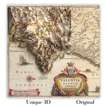
For something truly unique, this map is also available in "Unique 3D", our trademarked process that dramatically transforms the map so that it has a wonderful sense of depth. We combine the original map with detailed topography and elevation data, so that mountains and the terrain really "pop". For more info and examples of 3D maps, check my Unique 3D page.
For most orders, delivery time is about 3 working days. Personalised and customised products take longer, as I have to do the personalisation and send it to you for approval, which usually takes 1 or 2 days.
Please note that very large framed orders usually take longer to make and deliver.
If you need your order to arrive by a certain date, please contact me before you order so that we can find the best way of making sure you get your order in time.
I print and frame maps and artwork in 23 countries around the world. This means your order will be made locally, which cuts down on delivery time and ensures that it won't be damaged during delivery. You'll never pay customs or import duty, and we'll put less CO2 into the air.
All of my maps and art prints are well packaged and sent in a rugged tube if unframed, or surrounded by foam if framed.
I try to send out all orders within 1 or 2 days of receiving your order, though some products (like face masks, mugs and tote bags) can take longer to make.
If you select Express Delivery at checkout your order we will prioritise your order and send it out by 1-day courier (Fedex, DHL, UPS, Parcelforce).
Next Day delivery is also available in some countries (US, UK, Singapore, UAE) but please try to order early in the day so that we can get it sent out on time.
My standard frame is a gallery style black ash hardwood frame. It is simple and quite modern looking. My standard frame is around 20mm (0.8in) wide.
I use super-clear acrylic (perspex/acrylite) for the frame glass. It's lighter and safer than glass - and it looks better, as the reflectivity is lower.
Six standard frame colours are available for free (black, dark brown, dark grey, oak, white and antique gold). Custom framing and mounting/matting is available if you're looking for something else.
Most maps, art and illustrations are also available as a framed canvas. We use matte (not shiny) cotton canvas, stretch it over a sustainably sourced box wood frame, and then 'float' the piece within a wood frame. The end result is quite beautiful, and there's no glazing to get in the way.
All frames are provided "ready to hang", with either a string or brackets on the back. Very large frames will have heavy duty hanging plates and/or a mounting baton. If you have any questions, please get in touch.
See some examples of my framed maps and framed canvas maps.
Alternatively, I can also supply old maps and artwork on canvas, foam board, cotton rag and other materials.
If you want to frame your map or artwork yourself, please read my size guide first.
Alcune delle mie vecchie mappe sono ora disponibili come tele incorniciate. Per favore contattami se desideri ordinare una dimensione che non è disponibile nel mio negozio.
Le vecchie mappe su tela sono un'alternativa interessante alle mappe incorniciate in modo convenzionale. A seconda del tuo gusto personale e dell'arredamento della stanza, le mappe su tela possono "risaltare" un po' di più rispetto a una mappa incorniciata.
My maps are extremely high quality reproductions of original maps.
I source original, rare maps from libraries, auction houses and private collections around the world, restore them at my London workshop, and then use specialist giclée inks and printers to create beautiful maps that look even better than the original.
My maps are printed on acid-free archival matte (not glossy) paper that feels very high quality and almost like card. In technical terms the paper weight/thickness is 10mil/200gsm. It's perfect for framing.
I print with Epson ultrachrome giclée UV fade resistant pigment inks - some of the best inks you can find.
I can also make maps on canvas, cotton rag and other exotic materials.
Learn more about The Unique Maps Co.
Map personalisation
If you're looking for the perfect anniversary or housewarming gift, I can personalise your map to make it truly unique. For example, I can add a short message, or highlight an important location, or add your family's coat of arms.
The options are almost infinite. Please see my map personalisation page for some wonderful examples of what's possible.
To order a personalised map, select "personalise your map" before adding it to your basket.
Get in touch if you're looking for more complex customisations and personalisations.
Map ageing
I have been asked hundreds of times over the years by customers if they could buy a map that looks even older.
Well, now you can, by selecting Aged before you add a map to your basket.
All the product photos you see on this page show the map in its Original form. This is what the map looks like today.
If you select Aged, I will age your map by hand, using a special and unique process developed through years of studying old maps, talking to researchers to understand the chemistry of aging paper, and of course... lots of practice!
If you're unsure, stick to the Original colour of the map. If you want something a bit darker and older looking, go for Aged.
Se non sei soddisfatto del tuo ordine per qualsiasi motivo, contattami per un rimborso senza problemi. Si prega di consultare la nostra politica di reso e rimborso per ulteriori informazioni.
Sono molto sicuro che ti piacerà la tua mappa restaurata o la stampa d'arte. Lo faccio dal 1984. Sono un venditore Etsy a 5 stelle. Ho venduto decine di migliaia di mappe e stampe d'arte e ho oltre 5.000 recensioni reali a 5 stelle.
Utilizzo un processo unico per restaurare mappe e opere d'arte che richiede molto tempo e lavoro. Trovare le mappe e le illustrazioni originali può richiedere mesi. Utilizzo tecnologia all'avanguardia e incredibilmente costosa per scannerizzare e restaurarle. Di conseguenza, garantisco che le mie mappe e stampe d'arte siano superiori alle altre - ecco perché posso offrire un rimborso senza problemi.
Quasi tutte le mie mappe e stampe d'arte sembrano fantastiche a grandi dimensioni (200 cm, 6,5 piedi+) e posso anche incorniciarle e consegnarle a te, tramite un corriere speciale per oggetti di grandi dimensioni. Contattami per discutere delle tue esigenze specifiche.
Or try searching for something!


