


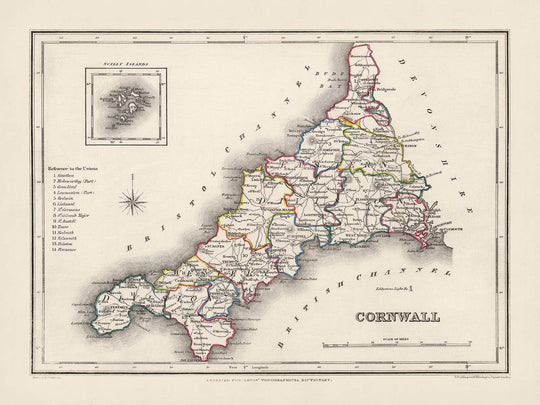


Mappa antica della Cornovaglia di Samuel Lewis, 1844: St Austell, Truro, Falmouth, Penzance e Newquay
20% di sconto su 2 — 33% di sconto su 3
Aggiungi qualsiasi due articoli idonei al tuo carrello per ricevere 20% di sconto. Aggiungi un terzo e sarà gratuito (equivalente a 33% di sconto quando acquisti tre).
Nessun codice necessario — l'offerta si applica automaticamente al checkout.
Valido su tutte le mappe standard e le stampe d'arte fine. Puoi mescolare e abbinare qualsiasi design.
Se desideri spedire articoli a più indirizzi, ti preghiamo di contattarci prima di effettuare il tuo ordine.
Le commissioni personalizzate e su misura sono escluse.
Contattaci se hai domande
-
![]() Made to order locally in the USA
Made to order locally in the USA

-
Free delivery 2-3 days ⓘ
Free delivery in 2-3 days
Your map should be delivered in 2-3 working days with free delivery, worldwide.
We make maps by hand locally in 23 countries. If you're buying a gift for someone in another country, we will make the map locally to them.
You will never pay import tax or customs duty.
Express delivery is available at checkout which can reduce the delivery time to 1-2 days.
Please note that personalised maps, and larger framed maps, can take longer to produce and deliver.
If you need your order to arrive by a certain date, contact me and we can discuss your options.
-
Complimentary gifting & design advice
ⓘ
Complimentary gifting & design advice
Available almost 24/7 on WhatsApp and email — we usually reply within minutes. We can help you:
- Choose a perfectly personalised gift
- Send a digital gift preview to the recipient
- Pick the ideal size for your wall
- Select the right finish and frame
Quick, friendly advice so you can order with confidence.
For last minute gifts, consider buying a digital gift card. We have over 5,000 maps and art prints to choose from.
-
90-day returns & 5-year guarantee
ⓘ
90 giorni per restituire e ricevere un rimborso
I prodotti possono essere restituiti entro 90 giorni per un rimborso completo, o cambio con un altro prodotto.
Per articoli personalizzati e su misura, potremmo offrirti un credito in negozio o una carta regalo non scadente, poiché non possiamo rivendere ordini personalizzati.
Se hai domande, contattaci. Per ulteriori informazioni, consulta la nostra politica di restituzione e cambio.

This is a museum-grade archival print from the original 1844 map — restored in our workshop and made to order on 220gsm archival matte paper or 400gsm artist's cotton canvas with pigment inks.
Professional framing & free personalisation available.
1. Choose a size
2. Frame & personalize your map
Make your map unique with framing, hand-drawn customisation, vintage ageing, pop art text, unique 3D styling and more.


Gift message & custom finish

If you want to add a gift message, or a finish (jigsaw, aluminium board, etc.) that is not available here, please request it in the "order note" when you check out.
Every order is custom made, so if you need the size adjusted slightly, or printed on an unusual material, just let us know. We've done thousands of custom orders over the years, so there's (almost) nothing we can't manage.
You can also contact us before you order, if you prefer!

- Handmade locally. No import duty or tax
- FREE worldwide delivery
- 90-day returns & 5-year product guarantee
- Questions? WhatsApp me any time
Own a piece of history
7,000+ 5 star reviews


Immergiti in un viaggio avvincente nel tempo con questa mappa impeccabile del 1844 della Contea di Cornwall di Samuel Lewis. Questo affascinante artefatto non solo offre un'interessante panoramica sulla Cornwall com'era a metà del XIX secolo, ma funge anche da ponte verso il suo passato vibrante. È una testimonianza delle radici del paesaggio moderno della Cornwall, comprese le città che potresti non trovare oggi con gli stessi nomi.
Ecco un'opportunità emozionante per esplorare questo pezzo di storia dove potresti scoprire le prime iterazioni delle città moderne, o in alcuni casi entusiasmanti, insediamenti che potrebbero non apparire affatto sulle mappe contemporanee. Questa mappa presenta anche una mappa in dettaglio delle Isole Scilly, aggiungendo un ulteriore strato di intrigo a questo già affascinante pezzo.
Insediamenti all'interno dei confini storici della Cornwall
- St Austell: Fondata nel XII secolo. Nota per la sua industria della china clay.
- Truro: Stabilita come città nel XII secolo. Conosciuta per la Cattedrale di Truro e come centro amministrativo della Cornwall.
- Falmouth: Concessa in carta nel 1661. Famosa per il suo profondo porto naturale.
- Penzance: Ricevette diritti di mercato nel 1332. Porta per le Isole Scilly.
- Newquay: Nota come villaggio di pescatori nel XV secolo. Famosa come meta per il surf.
- Camborne: Menziata nel Domesday Book, 1086. Storica città mineraria.
- Redruth: Nota per esistere fin dal XII secolo. Un altro centro dell'industria mineraria cornica.
- Saltash: Riferita come città di mercato nel XII secolo. Nota per il Royal Albert Bridge.
- Bodmin: Registrata nel Domesday Book, 1086. Casa di Bodmin Jail e Bodmin Moor.
- St Ives: Menziata in documenti dal V secolo. Nota come rifugio per artisti.
- Liskeard: Menziata nel Domesday Book, 1086. Porta per Bodmin Moor.
- Launceston: Registrata nel Domesday Book, 1086. Storica capitale della Cornwall.
- Helston: Nota come città almeno dal 1086. Famosa per il Furry Dance.
- Porthleven: Stabilita come porto all'inizio del XIX secolo. Nota per il suo iconico orologio.
- Torpoint: Nota dal XVIII secolo. Famosa per il suo servizio di traghetto verso Plymouth.
- Hayle: Nota come insediamento dall'inizio del XVIII secolo. Nota per il suo patrimonio industriale.
- Wadebridge: Nota come città dal XV secolo. Rinomata per il Royal Cornwall Show.
- St Just: Registrata nel XV secolo. Famosa per la sua storia mineraria.
- Padstow: Nota come porto dal X secolo. Rinomata per il suo festival gastronomico.
- Bude: Nota come città portuale dal XVI secolo. Nota per le sue spiagge.
- Callington: Menziata nel VII secolo. Famosa per il suo percorso murale.
- Lostwithiel: Nota dal XII secolo. Una volta capitale della Cornwall.
- St Mawes: Nota dal XVI secolo. Famosa per il Castello di St Mawes.
- Looe: Nota dal XIII secolo. Nota come città di pescatori.
- Fowey: Nota dal XIV secolo. Famosa per il suo festival letterario.
- St Agnes: Nota dal XV secolo. Ricco patrimonio minerario.
- St Columb Major: Registrata nel IX secolo. Nota per il suo storico Hurling the Silver Ball.
- Perranporth: Nota dal XIX secolo. Rinomata per la sua ampia spiaggia sabbiosa.
- Tintagel: Menziionata nel XII secolo. Associata alle leggende di Re Artù.
- Port Isaac: Conosciuto sin dal XIV secolo. Famoso per la serie TV 'Doc Martin'.
Attrazioni naturali notevoli in Cornovaglia
Land's End, il punto più occidentale della terraferma inglese, il Eden Project, un complesso ecosistemico e attrazione turistica, e Bodmin Moor, un'area designata di straordinaria bellezza naturale.
Eventi storici in Cornovaglia (1800-1850)
Durante il periodo 1800-1850, la Cornovaglia era in fermento, soprattutto a causa del boom minerario. L'area divenne globalmente riconosciuta per la sua produzione di stagno e rame. La Royal Geological Society of Cornwall fu fondata nel 1814, sottolineando ulteriormente l'importanza dell'industria mineraria e degli studi geologici in questa regione. La fondazione della Cornovaglia Railway nel 1846 fu un altro evento significativo, segnando una nuova era di trasporti nella contea.
Si prega di controllare attentamente le immagini per assicurarsi che una specifica città o luogo sia mostrato su questa mappa. Puoi anche contattarci e chiedere di controllare la mappa per te.
Questa mappa appare fantastica in tutte le dimensioni: 8x10in (20.5x25.5cm), 12x16in (30.5x41cm), 18x24in (45.5x61cm), 16x20in (40.5x51cm), 24x36in (61x91.5cm), 30x40in (76x101.5cm) e 37x50in (94x127cm), ma appare ancora meglio se stampata grande.
Posso creare bellissime stampe grandi di questa mappa fino a 50in (127cm). Ti prego di contattarmi se stai cercando opzioni di incorniciatura più grandi, personalizzate o diverse.
Il modello nelle immagini dell'elenco tiene la versione 18x24in (45.5x61cm) di questa mappa.
La quinta immagine dell'elenco mostra un esempio del mio servizio di personalizzazione della mappa.
Se stai cercando qualcosa di leggermente diverso, dai un'occhiata alla mia collezione di mappe del Regno Unito e dell'Irlanda.
Per favore contattami per controllare se una certa posizione, punto di riferimento o caratteristica è mostrata su questa mappa.
Questo sarebbe un meraviglioso regalo per un compleanno, Natale, Festa del Papà, partenza dal lavoro, anniversario o inaugurazione di una casa per qualcuno delle aree coperte da questa mappa.
Questa mappa è disponibile come stampa giclée su carta opaca archiviata senza acidi, oppure puoi acquistarla incorniciata. La cornice è una semplice cornice nera che si adatta alla maggior parte degli stili. Ti prego di contattarmi se desideri un colore o materiale della cornice diverso. Le mie cornici sono dotate di un vetro acrilico di grado museale super chiaro (perspex/acrylite), che è significativamente meno riflettente del vetro, più sicuro e arriverà sempre in perfette condizioni.
This map is also available as a float framed canvas, sometimes known as a shadow gap framed canvas or canvas floater. The map is printed on artist's cotton canvas and then stretched over a handmade box frame. We then "float" the canvas inside a wooden frame, which is available in a range of colours (black, dark brown, oak, antique gold and white). This is a wonderful way to present a map without glazing in front. See some examples of float framed canvas maps and explore the differences between my different finishes.
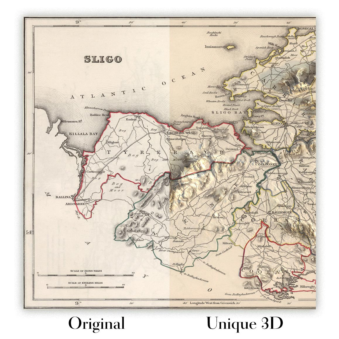
For something truly unique, this map is also available in "Unique 3D", our trademarked process that dramatically transforms the map so that it has a wonderful sense of depth. We combine the original map with detailed topography and elevation data, so that mountains and the terrain really "pop". For more info and examples of 3D maps, check my Unique 3D page.
For most orders, delivery time is about 3 working days. Personalised and customised products take longer, as I have to do the personalisation and send it to you for approval, which usually takes 1 or 2 days.
Please note that very large framed orders usually take longer to make and deliver.
If you need your order to arrive by a certain date, please contact me before you order so that we can find the best way of making sure you get your order in time.
I print and frame maps and artwork in 23 countries around the world. This means your order will be made locally, which cuts down on delivery time and ensures that it won't be damaged during delivery. You'll never pay customs or import duty, and we'll put less CO2 into the air.
All of my maps and art prints are well packaged and sent in a rugged tube if unframed, or surrounded by foam if framed.
I try to send out all orders within 1 or 2 days of receiving your order, though some products (like face masks, mugs and tote bags) can take longer to make.
If you select Express Delivery at checkout your order we will prioritise your order and send it out by 1-day courier (Fedex, DHL, UPS, Parcelforce).
Next Day delivery is also available in some countries (US, UK, Singapore, UAE) but please try to order early in the day so that we can get it sent out on time.
My standard frame is a gallery style black ash hardwood frame. It is simple and quite modern looking. My standard frame is around 20mm (0.8in) wide.
I use super-clear acrylic (perspex/acrylite) for the frame glass. It's lighter and safer than glass - and it looks better, as the reflectivity is lower.
Six standard frame colours are available for free (black, dark brown, dark grey, oak, white and antique gold). Custom framing and mounting/matting is available if you're looking for something else.
Most maps, art and illustrations are also available as a framed canvas. We use matte (not shiny) cotton canvas, stretch it over a sustainably sourced box wood frame, and then 'float' the piece within a wood frame. The end result is quite beautiful, and there's no glazing to get in the way.
All frames are provided "ready to hang", with either a string or brackets on the back. Very large frames will have heavy duty hanging plates and/or a mounting baton. If you have any questions, please get in touch.
See some examples of my framed maps and framed canvas maps.
Alternatively, I can also supply old maps and artwork on canvas, foam board, cotton rag and other materials.
If you want to frame your map or artwork yourself, please read my size guide first.
Alcune delle mie vecchie mappe sono ora disponibili come tele incorniciate. Per favore contattami se desideri ordinare una dimensione che non è disponibile nel mio negozio.
Le vecchie mappe su tela sono un'alternativa interessante alle mappe incorniciate in modo convenzionale. A seconda del tuo gusto personale e dell'arredamento della stanza, le mappe su tela possono "risaltare" un po' di più rispetto a una mappa incorniciata.
My maps are extremely high quality reproductions of original maps.
I source original, rare maps from libraries, auction houses and private collections around the world, restore them at my London workshop, and then use specialist giclée inks and printers to create beautiful maps that look even better than the original.
My maps are printed on acid-free archival matte (not glossy) paper that feels very high quality and almost like card. In technical terms the paper weight/thickness is 10mil/200gsm. It's perfect for framing.
I print with Epson ultrachrome giclée UV fade resistant pigment inks - some of the best inks you can find.
I can also make maps on canvas, cotton rag and other exotic materials.
Learn more about The Unique Maps Co.
Map personalisation
If you're looking for the perfect anniversary or housewarming gift, I can personalise your map to make it truly unique. For example, I can add a short message, or highlight an important location, or add your family's coat of arms.
The options are almost infinite. Please see my map personalisation page for some wonderful examples of what's possible.
To order a personalised map, select "personalise your map" before adding it to your basket.
Get in touch if you're looking for more complex customisations and personalisations.
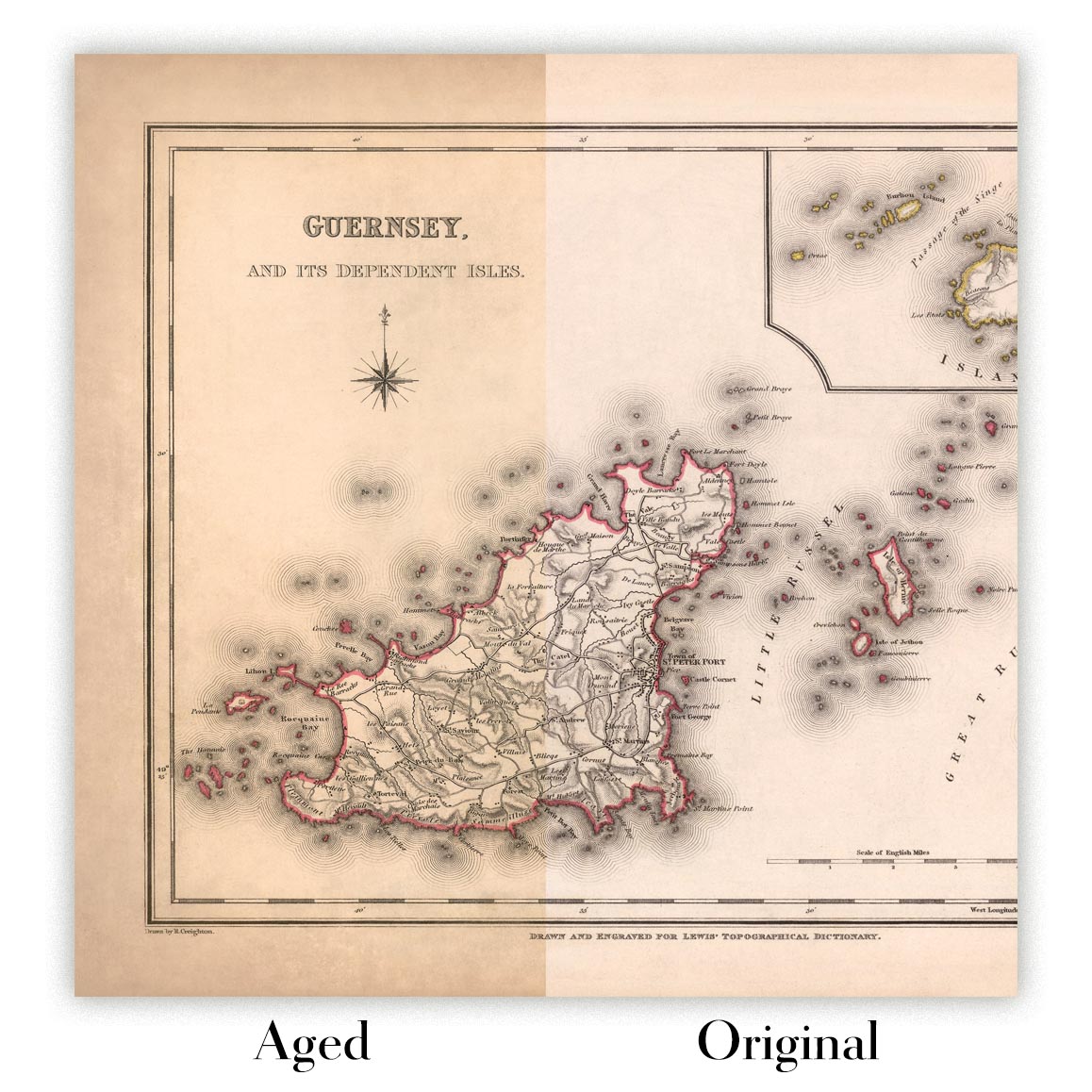
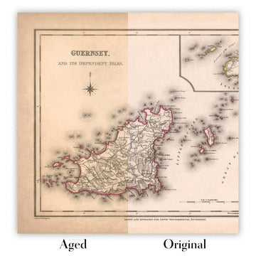
Map ageing
I have been asked hundreds of times over the years by customers if they could buy a map that looks even older.
Well, now you can, by selecting Aged before you add a map to your basket.
All the product photos you see on this page show the map in its Original form. This is what the map looks like today.
If you select Aged, I will age your map by hand, using a special and unique process developed through years of studying old maps, talking to researchers to understand the chemistry of aging paper, and of course... lots of practice!
If you're unsure, stick to the Original colour of the map. If you want something a bit darker and older looking, go for Aged.
Se non sei soddisfatto del tuo ordine per qualsiasi motivo, contattami per un rimborso senza problemi. Si prega di consultare la nostra politica di reso e rimborso per ulteriori informazioni.
Sono molto sicuro che ti piacerà la tua mappa restaurata o la stampa d'arte. Lo faccio dal 1984. Sono un venditore Etsy a 5 stelle. Ho venduto decine di migliaia di mappe e stampe d'arte e ho oltre 5.000 recensioni reali a 5 stelle.
Utilizzo un processo unico per restaurare mappe e opere d'arte che richiede molto tempo e lavoro. Trovare le mappe e le illustrazioni originali può richiedere mesi. Utilizzo tecnologia all'avanguardia e incredibilmente costosa per scannerizzare e restaurarle. Di conseguenza, garantisco che le mie mappe e stampe d'arte siano superiori alle altre - ecco perché posso offrire un rimborso senza problemi.
Quasi tutte le mie mappe e stampe d'arte sembrano fantastiche a grandi dimensioni (200 cm, 6,5 piedi+) e posso anche incorniciarle e consegnarle a te, tramite un corriere speciale per oggetti di grandi dimensioni. Contattami per discutere delle tue esigenze specifiche.
Or try searching for something!


