


Mappa pittorica dello Utah di Ruth Taylor White, 1935: Salt Lake City, Zion, Arches, Grande Lago Salato, Monti Wasatch
Compra 2, Ricevi 1 Gratuito
Se aggiungi 2 articoli al tuo carrello, puoi aggiungere un terzo prodotto gratuitamente.
Questo vale per tutte le mappe e opere d'arte, comprese le opere personalizzate e su misura. Puoi ordinare 3 dello stesso articolo, o 3 articoli diversi.
Questo equivale a uno sconto del 33%, che sarà il maggiore sconto disponibile nel mio negozio quest'anno.
Ti prego di approfittare dell'offerta e di coprire le tue pareti con bellissime mappe e opere d'arte!
Contattami se hai domande.
-
![]() Handmade in the USA
Handmade in the USA

-
FREE worldwide delivery in 2-3 days ⓘ
Free delivery in 2-3 days
Your map should be delivered in 2-3 working days with free delivery, worldwide.
We make maps by hand locally in 23 countries. If you're buying a gift for someone in another country, we will make the map locally to them.
You will never pay import tax or customs duty.
Express delivery is available at checkout which can reduce the delivery time to 1-2 days.
Please note that personalised maps, and larger framed maps, can take longer to produce and deliver.
If you need your order to arrive by a certain date, contact me and we can discuss your options.
-
Complimentary gifting & design advice
ⓘ
Complimentary gifting & design advice
Available almost 24/7 on WhatsApp and email — we usually reply within minutes. We can help you:
- Choose a perfectly personalised gift
- Send a digital gift preview to the recipient
- Pick the ideal size for your wall
- Select the right finish and frame
Quick, friendly advice so you can order with confidence.
For last minute gifts, consider buying a digital gift card. We have over 5,000 maps and art prints to choose from.
-
90-day returns & 5-year guarantee
ⓘ
90 giorni per restituire e ricevere un rimborso
I prodotti possono essere restituiti entro 90 giorni per un rimborso completo, o cambio con un altro prodotto.
Per articoli personalizzati e su misura, potremmo offrirti un credito in negozio o una carta regalo non scadente, poiché non possiamo rivendere ordini personalizzati.
Se hai domande, contattaci. Per ulteriori informazioni, consulta la nostra politica di restituzione e cambio.

This is a museum-grade archival print from the original 1935 map — restored in our workshop and made to order on 220gsm archival matte paper or 400gsm artist's cotton canvas with pigment inks.
Professional framing & free personalisation available
1. Choose a size
2. Frame & personalize your map
Make your map unique with framing, hand-drawn customisation, vintage ageing, pop art text, unique 3D styling and more.


Gift message & custom finish

If you want to add a gift message, or a finish (jigsaw, aluminium board, etc.) that is not available here, please request it in the "order note" when you check out.
Every order is custom made, so if you need the size adjusted slightly, or printed on an unusual material, just let us know. We've done thousands of custom orders over the years, so there's (almost) nothing we can't manage.
You can also contact us before you order, if you prefer!

- Handmade locally. No import duty or tax
- FREE worldwide delivery
- 90-day returns & 5-year product guarantee
- Questions? WhatsApp me any time
Own a piece of history
7,000+ 5 star reviews


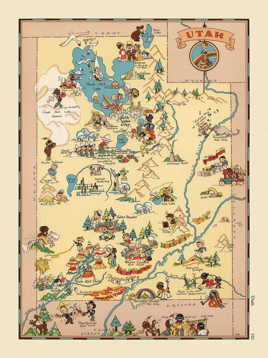
Entra nel vibrante mondo della cartografia americana dell'inizio del XX secolo con “Utah..,” la mappa pittorica originale del 1935 di Ruth Taylor White. Quest'opera affascinante è un pezzo distintivo della celebre serie di atlanti cartoni di White, dove ogni stato prende vita attraverso una lente giocosa ma perspicace. Il titolo della mappa, “Utah..,” suggerisce l'approccio fantasioso del cartografo, invitando gli spettatori a esplorare i paesaggi storici e i tesori culturali dello stato. Lo stile distintivo di White è immediatamente evidente: colori vivaci, illustrazioni esagerate e un occhio attento sia per i dettagli geografici che culturali trasformano questa mappa in una vivace narrazione dell'identità dell'Utah negli anni '30.
Ruth Taylor White, figura pionieristica nella cartografia pittorica americana, era rinomata per la sua capacità di unire arte e precisione geografica. Le sue mappe sono più di semplici strumenti di navigazione: sono artefatti culturali che riflettono lo spirito della loro epoca. Il lavoro di White è caratterizzato da una narrazione visiva coinvolgente, in cui ogni illustrazione è accuratamente scelta per evocare il carattere unico della regione. In “Utah..,” combina magistralmente umorismo, contesto storico e orgoglio regionale, rendendo la mappa sia una risorsa educativa che un delizioso pezzo di conversazione per collezionisti e appassionati.
Il design della mappa è una festa per gli occhi, adornato con vivide rappresentazioni delle meraviglie naturali e dei monumenti più iconici dell'Utah. Il Grande Lago Salato cattura l'attenzione, circondato dalla bellezza austera delle Bonneville Salt Flats e dall'espansione misteriosa del Grande Lago Salato Desert. Tesori nazionali come il Parco Nazionale di Zion, il Parco Nazionale di Bryce Canyon e il Monumento Nazionale di Arches sono splendidamente illustrati, con le loro formazioni geologiche distintive rese nello stile caratteristico di White. Le Montagne Wasatch e Uinta si ergono maestose, mentre i fiumi Colorado e Green si snodano attraverso il paesaggio, evidenziando la drammatica topografia dello stato.
Oltre alle sue caratteristiche naturali, “Utah..” offre una finestra sulla vita economica e culturale dello stato negli anni '30. La mappa è punteggiata da affascinanti vignette che rappresentano le industrie locali, il folklore e la vita quotidiana dei residenti dell'Utah. I confini delle contee sono chiaramente delineati, fornendo un senso di ordine in mezzo all'esuberanza artistica. L'approccio giocoso della mappa non sminuisce il suo valore informativo; piuttosto, migliora l'apprezzamento del pubblico per il ricco patrimonio e i paesaggi diversificati dell'Utah, rendendola un'aggiunta superba a qualsiasi collezione di Americana storica.
Gli insediamenti umani sono rappresentati con attenzione, con Salt Lake City e altre città chiave come Provo, Ogden e St. George in evidenza. Ogni città e paese è collocato nel suo contesto geografico, riflettendo sia la sua importanza storica che il suo posto duraturo nella storia dell'Utah. Che tu sia un collezionista esperto, un amante della storia o un ammiratore dell'arte cartografica fine, “Utah..” di Ruth Taylor White è una testimonianza del potere duraturo delle mappe di ispirare curiosità, celebrare il luogo e connetterci al passato.
Città e paesi su questa mappa
- Salt Lake City
- West Jordan
- Provo
- Orem
- Ogden
- St. George
- Layton
- Logan
- Murray
- Bountiful
- Tooele
- Cedar City
- Brigham City
- Price
- Richfield
- Moab
- Vernal
- Kanab
- Panguitch
- Fillmore
Caratteristiche e monumenti notevoli
- Il Grande Lago Salato è illustrato e etichettato
- Il Parco Nazionale di Zion è rappresentato e etichettato
- Il Parco Nazionale di Bryce Canyon è rappresentato e etichettato
- Il Monumento Nazionale degli Archi è etichettato (ora Parco Nazionale degli Archi)
- Il Monumento Nazionale dei Ponti Naturali è etichettato
- La Valle dei Monumenti è illustrata e etichettata
- Le Montagne Wasatch sono illustrate
- Il Fiume Colorado è mostrato e etichettato
- Le Pianure Salate di Bonneville sono rappresentate
- Il Deserto del Grande Lago Salato è illustrato
- Il Deserto di Sevier è etichettato
- Il San Rafael Swell è illustrato
- Le Montagne Uinta sono rappresentate
- Il Fiume Verde è etichettato
- Il Deserto di Escalante è etichettato
Contesto storico e di design
- Creato da Ruth Taylor White nel 1935, una figura pionieristica nella cartografia pittorica americana
- Presenta illustrazioni vivaci e colorate in uno stile cartoonesco e pittorico, tipico del lavoro di White negli anni '30
- Fa parte di un atlante pittorico o cartone divertente e fantasioso degli Stati Uniti
- Le illustrazioni rappresentano scene e attività stereotipate rappresentative dell'Utah negli anni '30, riflettendo il contesto culturale e storico dell'epoca
- La mappa funge da artefatto storico, illustrando non solo la geografia ma anche atteggiamenti e convenzioni artistiche specifiche del periodo
- Offre un'idea di come l'Utah e la sua gente siano stati percepiti e rappresentati nella cultura popolare all'inizio del XX secolo
- Narrativa visiva coinvolgente con immagini giocose e esagerate, progettata per essere sia informativa che divertente
Si prega di controllare attentamente le immagini per assicurarsi che una specifica città o luogo sia mostrato su questa mappa. Puoi anche contattarci e chiedere di controllare la mappa per te.
Questa mappa appare fantastica in ogni dimensione, ma consiglio sempre di optare per una dimensione più grande se hai spazio. In questo modo puoi facilmente distinguere tutti i dettagli.
Questa mappa appare straordinaria in dimensioni fino a 50 pollici (125 cm). Se stai cercando una mappa più grande, per favore contattaci.
Il modello nelle immagini dell'annuncio tiene la versione di questa mappa 18x24 pollici (45x60 cm).
La quinta immagine dell'annuncio mostra un esempio del mio servizio di personalizzazione della mappa.
Se stai cercando qualcosa di leggermente diverso, dai un'occhiata alla mia collezione delle migliori mappe antiche per vedere se qualcosa attira la tua attenzione.
Per favore contattami per verificare se una certa posizione, punto di riferimento o caratteristica è mostrata su questa mappa.
Questo sarebbe un meraviglioso regalo di compleanno, Natale, Festa del Papà, partenza dal lavoro, anniversario o per una festa di inaugurazione per qualcuno delle aree coperte da questa mappa.
Questa mappa è disponibile come stampa giclée su carta opaca archivistica senza acidi, oppure puoi acquistarla incorniciata. La cornice è una semplice cornice nera che si adatta alla maggior parte degli stili. Per favore contattami se desideri un colore o un materiale di cornice diverso. Le mie cornici sono rivestite con acrilico museo superchiaro (perspex/acrylite), che è significativamente meno riflettente del vetro, più sicuro e arriverà sempre in perfette condizioni.
This map is also available as a float framed canvas, sometimes known as a shadow gap framed canvas or canvas floater. The map is printed on artist's cotton canvas and then stretched over a handmade box frame. We then "float" the canvas inside a wooden frame, which is available in a range of colours (black, dark brown, oak, antique gold and white). This is a wonderful way to present a map without glazing in front. See some examples of float framed canvas maps and explore the differences between my different finishes.
For something truly unique, this map is also available in "Unique 3D", our trademarked process that dramatically transforms the map so that it has a wonderful sense of depth. We combine the original map with detailed topography and elevation data, so that mountains and the terrain really "pop". For more info and examples of 3D maps, check my Unique 3D page.
For most orders, delivery time is about 3 working days. Personalised and customised products take longer, as I have to do the personalisation and send it to you for approval, which usually takes 1 or 2 days.
Please note that very large framed orders usually take longer to make and deliver.
If you need your order to arrive by a certain date, please contact me before you order so that we can find the best way of making sure you get your order in time.
I print and frame maps and artwork in 23 countries around the world. This means your order will be made locally, which cuts down on delivery time and ensures that it won't be damaged during delivery. You'll never pay customs or import duty, and we'll put less CO2 into the air.
All of my maps and art prints are well packaged and sent in a rugged tube if unframed, or surrounded by foam if framed.
I try to send out all orders within 1 or 2 days of receiving your order, though some products (like face masks, mugs and tote bags) can take longer to make.
If you select Express Delivery at checkout your order we will prioritise your order and send it out by 1-day courier (Fedex, DHL, UPS, Parcelforce).
Next Day delivery is also available in some countries (US, UK, Singapore, UAE) but please try to order early in the day so that we can get it sent out on time.
My standard frame is a gallery style black ash hardwood frame. It is simple and quite modern looking. My standard frame is around 20mm (0.8in) wide.
I use super-clear acrylic (perspex/acrylite) for the frame glass. It's lighter and safer than glass - and it looks better, as the reflectivity is lower.
Six standard frame colours are available for free (black, dark brown, dark grey, oak, white and antique gold). Custom framing and mounting/matting is available if you're looking for something else.
Most maps, art and illustrations are also available as a framed canvas. We use matte (not shiny) cotton canvas, stretch it over a sustainably sourced box wood frame, and then 'float' the piece within a wood frame. The end result is quite beautiful, and there's no glazing to get in the way.
All frames are provided "ready to hang", with either a string or brackets on the back. Very large frames will have heavy duty hanging plates and/or a mounting baton. If you have any questions, please get in touch.
See some examples of my framed maps and framed canvas maps.
Alternatively, I can also supply old maps and artwork on canvas, foam board, cotton rag and other materials.
If you want to frame your map or artwork yourself, please read my size guide first.
Alcune delle mie vecchie mappe sono ora disponibili come tele incorniciate. Per favore contattami se desideri ordinare una dimensione che non è disponibile nel mio negozio.
Le vecchie mappe su tela sono un'alternativa interessante alle mappe incorniciate in modo convenzionale. A seconda del tuo gusto personale e dell'arredamento della stanza, le mappe su tela possono "risaltare" un po' di più rispetto a una mappa incorniciata.
My maps are extremely high quality reproductions of original maps.
I source original, rare maps from libraries, auction houses and private collections around the world, restore them at my London workshop, and then use specialist giclée inks and printers to create beautiful maps that look even better than the original.
My maps are printed on acid-free archival matte (not glossy) paper that feels very high quality and almost like card. In technical terms the paper weight/thickness is 10mil/200gsm. It's perfect for framing.
I print with Epson ultrachrome giclée UV fade resistant pigment inks - some of the best inks you can find.
I can also make maps on canvas, cotton rag and other exotic materials.
Learn more about The Unique Maps Co.
Map personalisation
If you're looking for the perfect anniversary or housewarming gift, I can personalise your map to make it truly unique. For example, I can add a short message, or highlight an important location, or add your family's coat of arms.
The options are almost infinite. Please see my map personalisation page for some wonderful examples of what's possible.
To order a personalised map, select "personalise your map" before adding it to your basket.
Get in touch if you're looking for more complex customisations and personalisations.
Map ageing
I have been asked hundreds of times over the years by customers if they could buy a map that looks even older.
Well, now you can, by selecting Aged before you add a map to your basket.
All the product photos you see on this page show the map in its Original form. This is what the map looks like today.
If you select Aged, I will age your map by hand, using a special and unique process developed through years of studying old maps, talking to researchers to understand the chemistry of aging paper, and of course... lots of practice!
If you're unsure, stick to the Original colour of the map. If you want something a bit darker and older looking, go for Aged.
Se non sei soddisfatto del tuo ordine per qualsiasi motivo, contattami per un rimborso senza problemi. Si prega di consultare la nostra politica di reso e rimborso per ulteriori informazioni.
Sono molto sicuro che ti piacerà la tua mappa restaurata o la stampa d'arte. Lo faccio dal 1984. Sono un venditore Etsy a 5 stelle. Ho venduto decine di migliaia di mappe e stampe d'arte e ho oltre 5.000 recensioni reali a 5 stelle.
Utilizzo un processo unico per restaurare mappe e opere d'arte che richiede molto tempo e lavoro. Trovare le mappe e le illustrazioni originali può richiedere mesi. Utilizzo tecnologia all'avanguardia e incredibilmente costosa per scannerizzare e restaurarle. Di conseguenza, garantisco che le mie mappe e stampe d'arte siano superiori alle altre - ecco perché posso offrire un rimborso senza problemi.
Quasi tutte le mie mappe e stampe d'arte sembrano fantastiche a grandi dimensioni (200 cm, 6,5 piedi+) e posso anche incorniciarle e consegnarle a te, tramite un corriere speciale per oggetti di grandi dimensioni. Contattami per discutere delle tue esigenze specifiche.
Or try searching for something!


