


Vecchia mappa militare e stradale di Carcassonne di Viollet-le-Duc, 1854: Fortificazioni della Città, Castello, Basilica

-
![]() Handmade in the USA
Handmade in the USA
-
Christmas delivery: check the deadline
Free delivery in 3-4 days
Your map should be delivered in 3-4 working days with free delivery, worldwide.
Free delivery may arrive on time, but Express Delivery at checkout is safer. Unframed orders have a better chance of arriving in time with free delivery.
New for 2025: After you order, you can send a beautiful gift preview by email, if you're worried it won't arrive on time.
We make maps by hand locally in 23 countries. If you're buying a gift for someone in another country, we will make the map locally to them.
You will never pay import tax or customs duty.
Check the Christmas delivery guide for order deadlines. Delivery times are starting to slow down, and will continue to slow down towards Christmas.
Express delivery is available at checkout which can reduce the delivery time to 1-2 days.
Please note that personalised maps, and larger framed maps, can take longer to produce and deliver.
If you need your order to arrive by a certain date, contact me and we can discuss your options.
-
90 day money back guarantee
ⓘ
90 giorni per restituire e ricevere un rimborso
I prodotti possono essere restituiti entro 90 giorni per un rimborso completo, o cambio con un altro prodotto.
Per articoli personalizzati e su misura, potremmo offrirti un credito in negozio o una carta regalo non scadente, poiché non possiamo rivendere ordini personalizzati.
Se hai domande, contattaci. Per ulteriori informazioni, consulta la nostra politica di restituzione e cambio.

My maps are rare, museum-grade, restored old maps sourced from libraries, auction houses and private collections across the globe.
Framing & free personalisation available
1. Select your size
2. Frame & personalize your map
There is limited framing & personalisation capacity available. Order by 10am tomorrow for Christmas delivery.


Gift message & custom finish

If you want to add a gift message, or a finish (jigsaw, aluminium board, etc.) that is not available here, please request it in the "order note" when you check out.
Every order is custom made, so if you need the size adjusted slightly, or printed on an unusual material, just let us know. We've done thousands of custom orders over the years, so there's (almost) nothing we can't manage.
You can also contact us before you order, if you prefer!

- Handmade locally. No import duty or tax
- FREE Delivery by Christmas
- Love it or your money back (90 days)
- Questions? WhatsApp me any time
Own a piece of history
5,000+ 5 star reviews


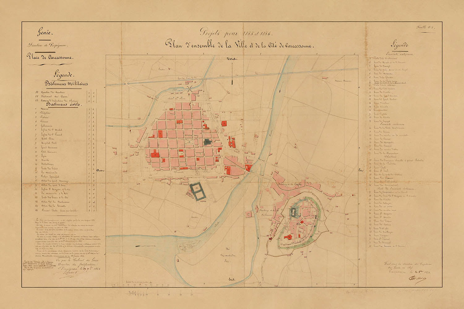
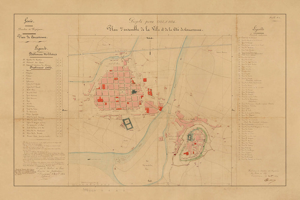
Il “Piano d'insieme della Ville e della Città di Carcassonne,” creato nel 1854 sotto la direzione di Eugène-Emmanuel Viollet-le-Duc e del Colonnello de Rivieres, rappresenta un notevole testimone dell'intersezione tra storia urbana, architettura militare e la nascente scienza della conservazione. Questa mappa della città manoscritta cattura Carcassonne in un momento cruciale—proprio mentre la sua rinomata restaurazione stava per iniziare—offrendo un raro e autentico spaccato delle fortificazioni medievali della città, della vivace città bassa e dell'intricato intreccio tra forme urbane antiche e moderne. Il titolo francese originale evoca la visione complessiva dei suoi creatori, che hanno documentato meticolosamente ogni bastione, ponte e boulevard in previsione dei cambiamenti radicali a venire.
Ciò che distingue questa mappa della città è il suo doppio focus: la cittadella fortificata di Carcassonne, un meraviglioso esempio di ingegneria militare medievale, e la Ville Basse, la vivace città bassa oltre il fiume Aude. La rappresentazione dettagliata della Citée a doppia muratura, completa di torri, barbican e dell'imponente Château Comtal, rivela le formidabili difese della città—mai violate durante la Guerra dei Cent'Anni e praticamente intatte durante il famigerato raid del Principe Nero. Monumenti come la Basilica di Saint-Nazaire, già in fase di restauro all'epoca, sono chiaramente segnati, evidenziando il ricco patrimonio religioso e architettonico della città.
L'arte della mappa risiede non solo nella sua precisa delineazione delle fortificazioni, ma anche nella sua attenta rappresentazione della vita civile di Carcassonne. La Ville Basse è mappata con uguale cura, la sua griglia stradale medievale e le piazze prominenti—come Place Carnot e Place Gambetta—parlano di secoli di evoluzione civica. Le curve eleganti del fiume Aude e i raffinati attraversamenti del Pont Vieux e del Pont Neuf collegano l'antica Citée ai vivaci quartieri della città bassa, illustrando la dinamica relazione della città con il suo paesaggio e le sue vie d'acqua. Tali caratteristiche rendono questa mappa una risorsa inestimabile per chiunque sia affascinato dalle storie stratificate delle città europee.
Storicamente, questa mappa è di profonda importanza. Creata all'alba della campagna di restauro di mezzo secolo di Viollet-le-Duc, documenta Carcassonne così com'era prima della rimozione delle strutture successive e della cura riabilitativa delle sue mura, torri e porte. Le annotazioni e la legenda codificata a colori, che distinguono le fortificazioni civili e militari, riflettono la pianificazione meticolosa e la visione che alla fine avrebbero salvato Carcassonne dalla rovina. Di conseguenza, questa mappa non solo tracciava i contorni fisici di una città, ma anche le correnti intellettuali e culturali che hanno plasmato la pratica moderna della conservazione del patrimonio.
Eugène-Emmanuel Viollet-le-Duc, lo spirito guida della mappa, era un architetto visionario il cui lavoro a Carcassonne ha influenzato i principi di conservazione in tutto il mondo. Rinominato per i suoi restauri interpretativi di Notre Dame de Paris, Mont Saint-Michel e altri icone francesi, Viollet-le-Duc si avvicinò a Carcassonne con rigorosa competenza accademica e immaginazione creativa. La sua eredità, preservata in questa straordinaria mappa, non è semplicemente fatta di pietra e malta, ma di una profonda riverenza per la storia, la forma urbana e il potere duraturo del luogo. Per collezionisti, storici e intenditori d'arte cartografica, questa mappa offre una rara opportunità di possedere un pezzo della storia vivente di Carcassonne—una città le cui mura hanno testimoniato il passaggio di imperi, fedi e secoli.
Strade e vie su questa mappa
- Allée des Soupirs
- Avenue de la Gare
- Avenue du Pont Neuf
- Boulevard Barbès
- Boulevard de la Bastide
- Boulevard de la Cité
- Boulevard de la Préfecture
- Boulevard du Canal
- Boulevard du Commandant Roumens
- Boulevard Marcou
- Boulevard Omer Sarraut
- Boulevard Pasteur
- Boulevard Paul Sabatier
- Boulevard Pierre Curie
- Boulevard Voltaire
- Chemin de la Cité
- Chemin de la Madeleine
- Chemin du Pont Vieux
- Place Carnot
- Place Davilla
- Place Eggenfelden
- Place Gambetta
- Place Marcou
- Place Saint-Gimer
- Place Saint-Louis
- Pont Neuf
- Pont Vieux
- Rue Aimé Ramond
- Rue de la Barbacane
- Rue de Verdun
Caratteristiche e punti di riferimento notevoli
- La cittadella fortificata di Carcassonne, con il suo doppio anello di mura e numerose torri
- La Basilica di Saint-Nazaire (etichettata #20 in rosso), un importante punto di riferimento religioso e architettonico
- Il Château Comtal (Castello del Conte) all'interno della Città
- La Ville Basse (città bassa) dall'altra parte del fiume rispetto alla Città
- Il fiume Aude, che separa la Città dalla Ville Basse
- Ponti che attraversano il fiume Aude, collegando la Città e la Ville Basse
- Porta della città, inclusa la Porte Narbonnaise e la Porte de l'Aude
- Fortificazioni civili e militari, codificate a colori e annotate
- Una legenda dettagliata a sinistra della mappa
- Annotazioni estese e note di progetto nell'angolo in basso a sinistra
- Torri difensive e bastioni lungo le mura
- L'area tra le due linee di mura (le "liste"), successivamente liberata da case durante il restauro
- Spazi aperti e piazze prominenti all'interno della città
- Il design concentrici delle fortificazioni della Città
- Il recinto fortificato rettangolare del castello
- La rete stradale medievale della Ville Basse
- La riva del fiume e le sponde lungo l'Aude
Contesto storico e di design
- Creato nel 1854 sotto la direzione di Eugène-Emmanuel Viollet-le-Duc e del Colonnello de Rivieres, come parte della pianificazione del restauro per Carcassonne.
- Documenta Carcassonne all'inizio della sua influente restaurazione del XIX secolo, prima di grandi cambiamenti e demolizioni.
- Mostra sia la Città fortificata che la Ville Basse, catturando il carattere duale della città.
- Presenta un ampio design manoscritto con fortificazioni civili e militari codificate a colori e una legenda completa.
- Riflette il movimento intellettuale e culturale della Francia del XIX secolo per preservare e restaurare monumenti medievali.
- Il restauro di Carcassonne da parte di Viollet-le-Duc divenne un modello per le pratiche moderne di conservazione e ha avuto una profonda influenza sulla preservazione del patrimonio.
- La mappa è un artefatto ufficiale, firmato dal Colonnello della Città, ed è stata utilizzata per la pianificazione urbana durante il regno di Napoleone III.
- Carcassonne è un sito patrimonio dell'umanità UNESCO, celebrato per le sue eccezionali fortificazioni medievali e l'eredità di restauro.
Si prega di controllare attentamente le immagini per assicurarsi che una specifica città o luogo sia mostrato su questa mappa. Puoi anche contattarci e chiedere di controllare la mappa per te.
Questa mappa appare fantastica in ogni dimensione, ma consiglio sempre di optare per una dimensione più grande se hai spazio. In questo modo puoi facilmente distinguere tutti i dettagli.
Questa mappa sembra fantastica in dimensioni fino a 50 pollici (125 cm). Se stai cercando una mappa più grande, per favore contattaci.
Si prega di notare: le etichette su questa mappa sono difficili da leggere se si ordina una mappa di 16 pollici (40 cm) o più piccola. La mappa è comunque molto attraente, ma se desideri leggere la mappa facilmente, ti preghiamo di acquistare una dimensione più grande.
Il modello nelle immagini dell'annuncio sta tenendo la versione 24x36 pollici (60x90 cm) di questa mappa.
La quinta immagine dell'annuncio mostra un esempio del mio servizio di personalizzazione della mappa.
Se stai cercando qualcosa di leggermente diverso, dai un'occhiata alla mia collezione dei migliori mappe antiche per vedere se qualcosa attira la tua attenzione.
Per favore contattami per verificare se una certa località, punto di riferimento o caratteristica è mostrata su questa mappa.
Questo sarebbe un meraviglioso regalo di compleanno, Natale, Festa del Papà, partenza dal lavoro, anniversario o inaugurazione della casa per qualcuno delle aree coperte da questa mappa.
Questa mappa è disponibile come stampa giclée su carta opaca archiviata senza acidi, oppure puoi acquistarla incorniciata. La cornice è una semplice cornice nera che si adatta alla maggior parte degli stili. Ti preghiamo di contattarci se desideri un colore o un materiale di cornice diverso. Le mie cornici sono vetriate con acrilico museum-grade super chiaro (perspex/acrylite), che è significativamente meno riflettente del vetro, più sicuro e arriverà sempre in perfette condizioni.
This map is also available as a float framed canvas, sometimes known as a shadow gap framed canvas or canvas floater. The map is printed on artist's cotton canvas and then stretched over a handmade box frame. We then "float" the canvas inside a wooden frame, which is available in a range of colours (black, dark brown, oak, antique gold and white). This is a wonderful way to present a map without glazing in front. See some examples of float framed canvas maps and explore the differences between my different finishes.
For something truly unique, this map is also available in "Unique 3D", our trademarked process that dramatically transforms the map so that it has a wonderful sense of depth. We combine the original map with detailed topography and elevation data, so that mountains and the terrain really "pop". For more info and examples of 3D maps, check my Unique 3D page.
For most orders, delivery time is about 3 working days. Personalised and customised products take longer, as I have to do the personalisation and send it to you for approval, which usually takes 1 or 2 days.
Please note that very large framed orders usually take longer to make and deliver.
If you need your order to arrive by a certain date, please contact me before you order so that we can find the best way of making sure you get your order in time.
I print and frame maps and artwork in 23 countries around the world. This means your order will be made locally, which cuts down on delivery time and ensures that it won't be damaged during delivery. You'll never pay customs or import duty, and we'll put less CO2 into the air.
All of my maps and art prints are well packaged and sent in a rugged tube if unframed, or surrounded by foam if framed.
I try to send out all orders within 1 or 2 days of receiving your order, though some products (like face masks, mugs and tote bags) can take longer to make.
If you select Express Delivery at checkout your order we will prioritise your order and send it out by 1-day courier (Fedex, DHL, UPS, Parcelforce).
Next Day delivery is also available in some countries (US, UK, Singapore, UAE) but please try to order early in the day so that we can get it sent out on time.
My standard frame is a gallery style black ash hardwood frame. It is simple and quite modern looking. My standard frame is around 20mm (0.8in) wide.
I use super-clear acrylic (perspex/acrylite) for the frame glass. It's lighter and safer than glass - and it looks better, as the reflectivity is lower.
Six standard frame colours are available for free (black, dark brown, dark grey, oak, white and antique gold). Custom framing and mounting/matting is available if you're looking for something else.
Most maps, art and illustrations are also available as a framed canvas. We use matte (not shiny) cotton canvas, stretch it over a sustainably sourced box wood frame, and then 'float' the piece within a wood frame. The end result is quite beautiful, and there's no glazing to get in the way.
All frames are provided "ready to hang", with either a string or brackets on the back. Very large frames will have heavy duty hanging plates and/or a mounting baton. If you have any questions, please get in touch.
See some examples of my framed maps and framed canvas maps.
Alternatively, I can also supply old maps and artwork on canvas, foam board, cotton rag and other materials.
If you want to frame your map or artwork yourself, please read my size guide first.
Alcune delle mie vecchie mappe sono ora disponibili come tele incorniciate. Per favore contattami se desideri ordinare una dimensione che non è disponibile nel mio negozio.
Le vecchie mappe su tela sono un'alternativa interessante alle mappe incorniciate in modo convenzionale. A seconda del tuo gusto personale e dell'arredamento della stanza, le mappe su tela possono "risaltare" un po' di più rispetto a una mappa incorniciata.
My maps are extremely high quality reproductions of original maps.
I source original, rare maps from libraries, auction houses and private collections around the world, restore them at my London workshop, and then use specialist giclée inks and printers to create beautiful maps that look even better than the original.
My maps are printed on acid-free archival matte (not glossy) paper that feels very high quality and almost like card. In technical terms the paper weight/thickness is 10mil/200gsm. It's perfect for framing.
I print with Epson ultrachrome giclée UV fade resistant pigment inks - some of the best inks you can find.
I can also make maps on canvas, cotton rag and other exotic materials.
Learn more about The Unique Maps Co.
Map personalisation
If you're looking for the perfect anniversary or housewarming gift, I can personalise your map to make it truly unique. For example, I can add a short message, or highlight an important location, or add your family's coat of arms.
The options are almost infinite. Please see my map personalisation page for some wonderful examples of what's possible.
To order a personalised map, select "personalise your map" before adding it to your basket.
Get in touch if you're looking for more complex customisations and personalisations.
Map ageing
I have been asked hundreds of times over the years by customers if they could buy a map that looks even older.
Well, now you can, by selecting Aged before you add a map to your basket.
All the product photos you see on this page show the map in its Original form. This is what the map looks like today.
If you select Aged, I will age your map by hand, using a special and unique process developed through years of studying old maps, talking to researchers to understand the chemistry of aging paper, and of course... lots of practice!
If you're unsure, stick to the Original colour of the map. If you want something a bit darker and older looking, go for Aged.
Se non sei soddisfatto del tuo ordine per qualsiasi motivo, contattami per un rimborso senza problemi. Si prega di consultare la nostra politica di reso e rimborso per ulteriori informazioni.
Sono molto sicuro che ti piacerà la tua mappa restaurata o la stampa d'arte. Lo faccio dal 1984. Sono un venditore Etsy a 5 stelle. Ho venduto decine di migliaia di mappe e stampe d'arte e ho oltre 5.000 recensioni reali a 5 stelle.
Utilizzo un processo unico per restaurare mappe e opere d'arte che richiede molto tempo e lavoro. Trovare le mappe e le illustrazioni originali può richiedere mesi. Utilizzo tecnologia all'avanguardia e incredibilmente costosa per scannerizzare e restaurarle. Di conseguenza, garantisco che le mie mappe e stampe d'arte siano superiori alle altre - ecco perché posso offrire un rimborso senza problemi.
Quasi tutte le mie mappe e stampe d'arte sembrano fantastiche a grandi dimensioni (200 cm, 6,5 piedi+) e posso anche incorniciarle e consegnarle a te, tramite un corriere speciale per oggetti di grandi dimensioni. Contattami per discutere delle tue esigenze specifiche.
Or try searching for something!


