


Mappa rara di Pasqua di La Pérouse, 1797: Baia di Cook, Oceano Pacifico

-
![]() Handmade in the USA
Handmade in the USA
-
FREE worldwide delivery in 2-3 days ⓘ
Free delivery in 2-3 days
Your map should be delivered in 2-3 working days with free delivery, worldwide.
We make maps by hand locally in 23 countries. If you're buying a gift for someone in another country, we will make the map locally to them.
You will never pay import tax or customs duty.
Express delivery is available at checkout which can reduce the delivery time to 1-2 days.
Please note that personalised maps, and larger framed maps, can take longer to produce and deliver.
If you need your order to arrive by a certain date, contact me and we can discuss your options.
-
90 day money back guarantee
ⓘ
90 giorni per restituire e ottenere un rimborso
I prodotti possono essere restituiti entro 90 giorni per un rimborso completo, o scambio con un altro prodotto.
Per articoli personalizzati o su misura, potremmo offrirti un credito in negozio o una carta regalo non scadente, poiché non possiamo rivendere ordini personalizzati.
Se hai domande, contattaci. Per ulteriori informazioni, consulta la nostra politica di restituzione e scambio.

My maps are rare, museum-grade, restored old maps sourced from libraries, auction houses and private collections across the globe.
Framing & free personalisation available
1. Select your size
2. Frame & personalize your map
Make your map unique with framing, hand-drawn customisation, vintage ageing, pop art text, unique 3D styling and moreGift message & custom finish

If you want to add a gift message, or a finish (jigsaw, aluminium board, etc.) that is not available here, please request it in the "order note" when you check out.
Every order is custom made, so if you need the size adjusted slightly, or printed on an unusual material, just let us know. We've done thousands of custom orders over the years, so there's (almost) nothing we can't manage.
You can also contact us before you order, if you prefer!

- Handmade locally. No import duty or tax
- FREE Delivery. Arrives in 2-3 days
- Love it or your money back
- Questions? WhatsApp me any time
Own a piece of history
5,000+ 5 star reviews


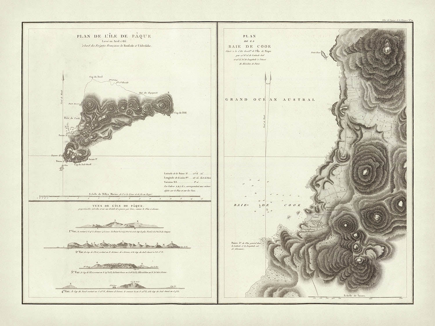
Entra nell'era dell'esplorazione dell'Illuminismo con "l'Ile de Paque, Baie de Cook," una mappa squisita del 1797 realizzata dal rinomato ufficiale navale e esploratore francese, Jean-François de Galaup La Pérouse. Questa mappa è una testimonianza dell'epoca d'oro della scoperta europea, catturando l'enigmatica Isola di Pasqua in un momento in cui i suoi misteri stavano appena iniziando a svelarsi per il mondo occidentale. L'approccio meticoloso di La Pérouse è evidente in ogni linea incisa, offrendo una finestra sulle ambizioni e sulla precisione della cartografia francese della fine del XVIII secolo.
Commissionata come parte del grande viaggio di La Pérouse per estendere le scoperte del Capitano James Cook, questa mappa è intrisa del dramma e del romanticismo dell'avventura marittima. Salpando dalla Francia nel 1785, La Pérouse cercò di mappare acque sconosciute e documentare terre che erano state recentemente portate all'attenzione degli esploratori europei. Anche se il suo viaggio finì tragicamente in un naufragio, le mappe e le narrazioni sopravvissute pubblicate nel 1797 immortalizzano le sue conquiste e continuano a ispirare meraviglia secoli dopo.
Il fulcro della mappa è l'Isola di Pasqua remota e leggendaria—île de Pâques—alla deriva nell'immensa distesa del Pacifico sudorientale. Senza città o insediamenti raffigurati, l'isolamento inquietante dell'isola è palpabile, sottolineando la sua reputazione come uno dei luoghi più misteriosi e iconici del mondo. I dettagliati contorni costieri, meticolosamente incisi, invitano lo spettatore a immaginare le prime navi europee che si avvicinano a queste coste impervie, guidate dai suoni e dai profili che La Pérouse registrò.
Un tratto distintivo di questa mappa è la sua eccezionale attenzione alla geografia fisica. Il rilievo è reso attraverso eleganti hachures, rivelando il terreno ondulato dell'isola e le sue prominenti elevazioni. Attorno alla massa terrestre, le misurazioni di profondità offrono preziose informazioni per i marinai, mentre quattro profili costieri forniscono impressioni visive straordinarie della costa viste dal ponte di una nave del XVIII secolo. Queste caratteristiche non solo servono a scopi di navigazione, ma evocano anche il senso di meraviglia e curiosità che guidava La Pérouse e i suoi contemporanei.
Storicamente, "l'Ile de Paque, Baie de Cook" è più di uno strumento di navigazione; è un artefatto culturale di un momento cruciale nell'esplorazione globale. Pubblicata nel prestigioso atlante francese che accompagna "Voyage de La Perouse autour du monde," questa mappa fa da ponte tra i mondi della scienza, dell'arte e dell'avventura. Rimane un raro e evocativo documento della visione di un esploratore leggendario—una visione che continua a catturare collezionisti, storici e amanti dei grandi tesori cartografici del mondo.
Città e paesi su questa mappa
- Non ci sono città, paesi o insediamenti umani etichettati o visibili su questa mappa.
Caratteristiche e punti di riferimento notevoli
- Mappe in dettaglio: La mappa include mappe in dettaglio o ingrandimenti di specifiche aree costiere etichettate "Baie de Cook" (Baia di Cook).
- Illustrazioni: Sono inclusi quattro profili costieri, che rappresentano visivamente l'aspetto della costa dal mare.
- Corpi idrici: Oceano Pacifico, specificamente le acque che circondano l'Isola di Pasqua.
- Punti di riferimento: Caratteristiche costiere prominenti, baie e promontori sono chiaramente etichettati.
- Montagne: Il rilievo è rappresentato da hachures, indicando la presenza di terreni elevati o colline sull'Isola di Pasqua.
- Misurazioni di profondità: Numerose misurazioni di profondità intorno alla costa, fornendo informazioni navigazionali per le imbarcazioni marittime.
Contesto storico e di design
- Nome della mappa: l'Ile de Paque, Baie de Cook.
- Cartografo: Jean-François de Galaup La Pérouse, un ufficiale navale e esploratore francese.
- Data di creazione: 1797.
- Creata come parte del grande viaggio di La Pérouse dalla Francia nel 1785, con l'obiettivo di estendere le scoperte del Capitano James Cook.
- Pubblicata postuma nell'Atlante che accompagna l'edizione francese di "Voyage de La Perouse autour du monde."
- La mappa è incisa, non colorata, e presenta il rilievo rappresentato da hachures e le profondità indicate da sonde.
- Quattro profili costieri forniscono rappresentazioni visive dettagliate della costa.
- La mappa è storicamente significativa in quanto una delle prime rappresentazioni cartografiche europee dettagliate dell'isola di Pasqua.
Si prega di controllare attentamente le immagini per assicurarsi che una specifica città o luogo sia mostrato su questa mappa. Puoi anche contattarci e chiederci di controllare la mappa per te.
Questa mappa appare fantastica in ogni dimensione, ma consiglio sempre di optare per una dimensione più grande se hai spazio. In questo modo puoi facilmente distinguere tutti i dettagli.
Questa mappa appare straordinaria in dimensioni fino a 50in (125cm). Se stai cercando una mappa più grande, per favore contattaci.
Il modello nelle immagini dell'annuncio tiene la versione 18x24in (45x60cm) di questa mappa.
La quinta immagine dell'annuncio mostra un esempio del mio servizio di personalizzazione della mappa.
Se stai cercando qualcosa di leggermente diverso, dai un'occhiata alla mia collezione delle migliori vecchie mappe per vedere se qualcosa attira la tua attenzione.
Per favore contattami per controllare se una certa località, punto di riferimento o caratteristica è mostrata su questa mappa.
Questa sarebbe un'ottima idea regalo per un compleanno, Natale, Festa del Papà, addio al lavoro, anniversario o inaugurazione della casa per qualcuno delle aree coperte da questa mappa.
Questa mappa è disponibile come stampa giclée su carta opaca archiviata senza acidi, oppure puoi acquistarla incorniciata. La cornice è una semplice cornice nera che si adatta alla maggior parte delle estetiche. Per favore contattaci se desideri un colore o un materiale di cornice diverso. Le mie cornici sono dotate di un acrilico (perspex/acrylite) di grado museale super chiaro, che è significativamente meno riflettente del vetro, più sicuro e arriverà sempre in perfette condizioni.
This map is also available as a float framed canvas, sometimes known as a shadow gap framed canvas or canvas floater. The map is printed on artist's cotton canvas and then stretched over a handmade box frame. We then "float" the canvas inside a wooden frame, which is available in a range of colours (black, dark brown, oak, antique gold and white). This is a wonderful way to present a map without glazing in front. See some examples of float framed canvas maps and explore the differences between my different finishes.
For something truly unique, this map is also available in "Unique 3D", our trademarked process that dramatically transforms the map so that it has a wonderful sense of depth. We combine the original map with detailed topography and elevation data, so that mountains and the terrain really "pop". For more info and examples of 3D maps, check my Unique 3D page.
For most orders, delivery time is about 3 working days. Personalised and customised products take longer, as I have to do the personalisation and send it to you for approval, which usually takes 1 or 2 days.
Please note that very large framed orders usually take longer to make and deliver.
If you need your order to arrive by a certain date, please contact me before you order so that we can find the best way of making sure you get your order in time.
I print and frame maps and artwork in 23 countries around the world. This means your order will be made locally, which cuts down on delivery time and ensures that it won't be damaged during delivery. You'll never pay customs or import duty, and we'll put less CO2 into the air.
All of my maps and art prints are well packaged and sent in a rugged tube if unframed, or surrounded by foam if framed.
I try to send out all orders within 1 or 2 days of receiving your order, though some products (like face masks, mugs and tote bags) can take longer to make.
If you select Express Delivery at checkout your order we will prioritise your order and send it out by 1-day courier (Fedex, DHL, UPS, Parcelforce).
Next Day delivery is also available in some countries (US, UK, Singapore, UAE) but please try to order early in the day so that we can get it sent out on time.
My standard frame is a gallery style black ash hardwood frame. It is simple and quite modern looking. My standard frame is around 20mm (0.8in) wide.
I use super-clear acrylic (perspex/acrylite) for the frame glass. It's lighter and safer than glass - and it looks better, as the reflectivity is lower.
Six standard frame colours are available for free (black, dark brown, dark grey, oak, white and antique gold). Custom framing and mounting/matting is available if you're looking for something else.
Most maps, art and illustrations are also available as a framed canvas. We use matte (not shiny) cotton canvas, stretch it over a sustainably sourced box wood frame, and then 'float' the piece within a wood frame. The end result is quite beautiful, and there's no glazing to get in the way.
All frames are provided "ready to hang", with either a string or brackets on the back. Very large frames will have heavy duty hanging plates and/or a mounting baton. If you have any questions, please get in touch.
See some examples of my framed maps and framed canvas maps.
Alternatively, I can also supply old maps and artwork on canvas, foam board, cotton rag and other materials.
If you want to frame your map or artwork yourself, please read my size guide first.
Alcune delle mie vecchie mappe sono ora disponibili come tele incorniciate. Per favore contattami se desideri ordinare una dimensione che non è disponibile nel mio negozio.
Le vecchie mappe su tela sono un'alternativa interessante alle mappe incorniciate in modo convenzionale. A seconda del tuo gusto personale e dell'arredamento della stanza, le mappe su tela possono "risaltare" un po' di più rispetto a una mappa incorniciata.
My maps are extremely high quality reproductions of original maps.
I source original, rare maps from libraries, auction houses and private collections around the world, restore them at my London workshop, and then use specialist giclée inks and printers to create beautiful maps that look even better than the original.
My maps are printed on acid-free archival matte (not glossy) paper that feels very high quality and almost like card. In technical terms the paper weight/thickness is 10mil/200gsm. It's perfect for framing.
I print with Epson ultrachrome giclée UV fade resistant pigment inks - some of the best inks you can find.
I can also make maps on canvas, cotton rag and other exotic materials.
Learn more about The Unique Maps Co.
Map personalisation
If you're looking for the perfect anniversary or housewarming gift, I can personalise your map to make it truly unique. For example, I can add a short message, or highlight an important location, or add your family's coat of arms.
The options are almost infinite. Please see my map personalisation page for some wonderful examples of what's possible.
To order a personalised map, select "personalise your map" before adding it to your basket.
Get in touch if you're looking for more complex customisations and personalisations.
Map ageing
I have been asked hundreds of times over the years by customers if they could buy a map that looks even older.
Well, now you can, by selecting Aged before you add a map to your basket.
All the product photos you see on this page show the map in its Original form. This is what the map looks like today.
If you select Aged, I will age your map by hand, using a special and unique process developed through years of studying old maps, talking to researchers to understand the chemistry of aging paper, and of course... lots of practice!
If you're unsure, stick to the Original colour of the map. If you want something a bit darker and older looking, go for Aged.
Se non sei soddisfatto del tuo ordine per qualsiasi motivo, contattami per un rimborso senza problemi. Si prega di consultare la nostra politica di reso e rimborso per ulteriori informazioni.
Sono molto sicuro che ti piacerà la tua mappa restaurata o la stampa d'arte. Lo faccio dal 1984. Sono un venditore Etsy a 5 stelle. Ho venduto decine di migliaia di mappe e stampe d'arte e ho oltre 5.000 recensioni reali a 5 stelle.
Utilizzo un processo unico per restaurare mappe e opere d'arte che richiede molto tempo e lavoro. Trovare le mappe e le illustrazioni originali può richiedere mesi. Utilizzo tecnologia all'avanguardia e incredibilmente costosa per scannerizzare e restaurarle. Di conseguenza, garantisco che le mie mappe e stampe d'arte siano superiori alle altre - ecco perché posso offrire un rimborso senza problemi.
Quasi tutte le mie mappe e stampe d'arte sembrano fantastiche a grandi dimensioni (200 cm, 6,5 piedi+) e posso anche incorniciarle e consegnarle a te, tramite un corriere speciale per oggetti di grandi dimensioni. Contattami per discutere delle tue esigenze specifiche.
Or try searching for something!


