


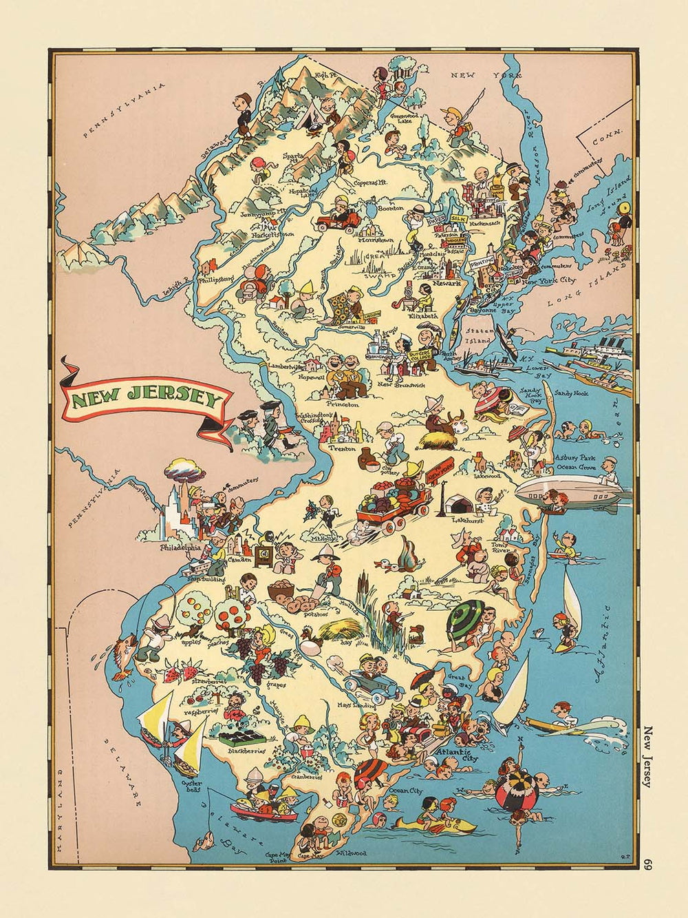


Mappa pittorica del New Jersey di Ruth Taylor White, 1935: Newark, Jersey Shore, Pine Barrens, Oceano Atlantico, Fiume Delaware

-
![]() Handmade in the USA
Handmade in the USA
-
FREE worldwide delivery in 2-3 days ⓘ
Free delivery in 2-3 days
Your map should be delivered in 2-3 working days with free delivery, worldwide.
We make maps by hand locally in 23 countries. If you're buying a gift for someone in another country, we will make the map locally to them.
You will never pay import tax or customs duty.
Express delivery is available at checkout which can reduce the delivery time to 1-2 days.
Please note that personalised maps, and larger framed maps, can take longer to produce and deliver.
If you need your order to arrive by a certain date, contact me and we can discuss your options.
-
90 day money back guarantee
ⓘ
90 giorni per restituire e ottenere un rimborso
I prodotti possono essere restituiti entro 90 giorni per un rimborso completo, o scambio con un altro prodotto.
Per articoli personalizzati o su misura, potremmo offrirti un credito in negozio o una carta regalo non scadente, poiché non possiamo rivendere ordini personalizzati.
Se hai domande, contattaci. Per ulteriori informazioni, consulta la nostra politica di restituzione e scambio.

My maps are rare, museum-grade, restored old maps sourced from libraries, auction houses and private collections across the globe.
Framing & free personalisation available
1. Select your size
2. Frame & personalize your map
Make your map unique with framing, hand-drawn customisation, vintage ageing, pop art text, unique 3D styling and moreGift message & custom finish

If you want to add a gift message, or a finish (jigsaw, aluminium board, etc.) that is not available here, please request it in the "order note" when you check out.
Every order is custom made, so if you need the size adjusted slightly, or printed on an unusual material, just let us know. We've done thousands of custom orders over the years, so there's (almost) nothing we can't manage.
You can also contact us before you order, if you prefer!

- Handmade locally. No import duty or tax
- FREE Delivery. Arrives in 2-3 days
- Love it or your money back
- Questions? WhatsApp me any time
Own a piece of history
5,000+ 5 star reviews


Entra nel mondo vibrante del New Jersey degli anni '30 con la mappa pittorica originale intitolata "New Jersey", una creazione affascinante della rinomata cartografa Ruth Taylor White. Questa mappa, realizzata nel 1935, è più di un semplice documento geografico—è una celebrazione visiva del tessuto culturale e dello spirito dinamico dello Stato Giardino durante un'epoca di trasformazione. Ogni angolo dello stato esplode con illustrazioni fantasiose, invitando gli spettatori a esplorare il New Jersey come veniva visto attraverso gli occhi di un osservatore giocoso ma perspicace. Il cartiglio decorativo del titolo della mappa e i bordi artistici segnalano immediatamente la fusione di arte e precisione cartografica che definisce questo pezzo unico.
Ruth Taylor White, una pioniera nel campo della cartografia pittorica, ha portato una miscela distintiva di umorismo, arte e intuizione regionale nel suo lavoro. Le sue mappe sono rinomate per il loro stile coinvolgente, che unisce una rappresentazione geografica dettagliata a vignette imaginative e simili a cartoni animati. In "New Jersey", il talento di White è inconfondibile: cattura abilmente i paesaggi e le industrie diverse dello stato, dalle fabbriche brulicanti del nord alle tranquille foreste di pini del sud. Le sue mappe non sono solo strumenti di navigazione, ma anche finestre sulla vita sociale ed economica del loro tempo, rendendole artefatti preziosi per collezionisti e storici.
Il design della mappa è un vivace tableau delle caratteristiche più definitive del New Jersey. Lungo il bordo orientale, l'Oceano Atlantico si dispiega in una serie di illustrazioni giocose, complete di bagnanti e divertimenti sul lungomare che evocano il fascino senza tempo della Jersey Shore. A ovest, il fiume Delaware è elegantemente rappresentato, segnando il confine naturale dello stato e fornendo uno sfondo per scene di pesca e attività marittime. Le Montagne Watchung si ergono a nord, la loro presenza enfatizzata dal tocco artistico affascinante di White, mentre le Pine Barrens del sud sono rappresentate con alberi fantasiosi e persino un cenno al leggendario Jersey Devil.
Integrale per l'appeal della mappa è la sua dettagliata rappresentazione del ricco patrimonio agricolo e industriale del New Jersey. Le contee meridionali fioriscono con immagini di coltivazione di mirtilli e mirtilli rossi, mentre le regioni centrali e settentrionali brulicano di fattorie lattiero-casearie, bestiame e i camini delle industrie del primo XX secolo. Le corse di cavalli, un passatempo sinonimo dello stato, sono vividamente illustrate, così come i porti vivaci e le pesca costiera che sono da lungo tempo vitali per l'economia del New Jersey. Ogni contea è accuratamente delineata e etichettata, fornendo un chiaro senso del luogo in mezzo all'arte exuberante.
La mappa funge anche da affascinante cronaca dello sviluppo urbano del New Jersey, con città e paesi come Newark, Jersey City, Paterson e Atlantic City in evidenza. Questi insediamenti non sono solo marcatori geografici, ma anche simboli della vitalità e della crescita durature dello stato. Intrecciando folklore regionale, monumenti storici e vita quotidiana, "New Jersey" di Ruth Taylor White offre un viaggio delizioso e perspicace attraverso il tempo—una testimonianza del potere duraturo della cartografia di informare e incantare.
Città e paesi su questa mappa
- Newark
- Jersey City
- Paterson
- Elizabeth
- Trenton
- Camden
- Clifton
- Passaic
- East Orange
- Bayonne
- Vineland
- New Brunswick
- Perth Amboy
- Plainfield
- Hackensack
- Atlantic City
- Kearny
- Linden
- Hoboken
- Morristown
- Orange
- Rahway
- Summit
- Bridgeton
- Millville
- Salem
- Cape May
Caratteristiche e luoghi notevoli
- Oceano Atlantico è illustrato e etichettato lungo il confine orientale del New Jersey.
- Il fiume Delaware è illustrato e etichettato lungo il confine occidentale dello stato.
- La regione dei Pine Barrens è rappresentata con illustrazioni di pini e riferimenti alla flora locale.
- Illustrazioni di attività agricole, come la coltivazione di mirtilli e mirtilli rossi, nel sud del New Jersey.
- Illustrazioni di attività industriale, comprese fabbriche e camini, nella parte settentrionale dello stato.
- La Jersey Shore è rappresentata con scene di spiaggia, inclusi bagnanti e divertimenti sul lungomare.
- Illustrazioni di corse di cavalli, facendo riferimento all'associazione storica del New Jersey con questo sport.
- Rappresentazioni di attività di pesca e marittime lungo la costa.
- Illustrazioni di allevamento di bestiame e agricoltura lattiero-casearia nel centro e nel nord del New Jersey.
- Le montagne Watchung sono illustrate e etichettate.
- Illustrazioni fantasiose del folklore locale e degli stereotipi culturali, come il "Jersey Devil" nei Pine Barrens.
- Il confine statale con la Pennsylvania è chiaramente contrassegnato.
- Il confine statale con New York è chiaramente contrassegnato.
- Il confine statale con il Delaware è chiaramente contrassegnato.
- La mappa include un cartiglio decorativo con il nome "New Jersey."
- I confini della contea sono delineati e etichettati in tutto lo stato.
Contesto storico e di design
- Creato nel 1935 da Ruth Taylor White, una pioniera nella cartografia pittorica.
- Parte di un atlante pittorico o cartoon fantasioso degli Stati Uniti, noto per il suo approccio divertente e immaginativo.
- Illustrazioni riccamente dettagliate e vivaci, utilizzando immagini simili a cartoni animati per rappresentare scene e aspetti stereotipati della vita nel New Jersey degli anni '30.
- Funziona sia come rappresentazione geografica che come commento storico, catturando le dinamiche culturali e sociali del New Jersey all'inizio del XX secolo.
- La mappa è un prodotto della cartografia americana del primo XX secolo che utilizzava elementi pittorici e tematici per coinvolgere e intrattenere gli spettatori, rendendo la geografia accessibile e divertente.
- Le mappe di Ruth Taylor White sono apprezzate per la loro fusione di umorismo, stereotipi regionali e flair artistico, contribuendo alla popolarità della cartografia pittorica negli Stati Uniti.
Si prega di controllare attentamente le immagini per assicurarsi che una specifica città o luogo sia mostrato su questa mappa. Puoi anche contattarci e chiedere di controllare la mappa per te.
Questa mappa sembra fantastica in ogni dimensione, ma consiglio sempre di optare per una dimensione più grande se hai spazio. In questo modo puoi facilmente distinguere tutti i dettagli.
Questa mappa appare sorprendente in dimensioni fino a 50in (125cm). Se stai cercando una mappa più grande, per favore contattaci.
Il modello nelle immagini dell'elenco tiene la versione 18x24in (45x60cm) di questa mappa.
La quinta immagine dell'elenco mostra un esempio del mio servizio di personalizzazione della mappa.
Se stai cercando qualcosa di leggermente diverso, dai un'occhiata alla mia collezione delle migliori mappe antiche per vedere se qualcosa attira la tua attenzione.
Si prega di contattarmi per verificare se una certa posizione, punto di riferimento o caratteristica è mostrata su questa mappa.
Questo sarebbe un meraviglioso regalo per un compleanno, Natale, Festa del Papà, pensionamento, anniversario o inaugurazione della casa per qualcuno delle aree coperte da questa mappa.
Questa mappa è disponibile come stampa giclée su carta opaca archivistica priva di acidi, oppure puoi acquistarla incorniciata. La cornice è una bella e semplice cornice nera che si adatta alla maggior parte degli stili. Ti preghiamo di contattarci se desideri un colore o un materiale diverso per la cornice. Le mie cornici sono dotate di vetro acrilico (perspex/acrylite) di grado museale super chiaro, che è significativamente meno riflettente del vetro, più sicuro e arriverà sempre in perfette condizioni.
This map is also available as a float framed canvas, sometimes known as a shadow gap framed canvas or canvas floater. The map is printed on artist's cotton canvas and then stretched over a handmade box frame. We then "float" the canvas inside a wooden frame, which is available in a range of colours (black, dark brown, oak, antique gold and white). This is a wonderful way to present a map without glazing in front. See some examples of float framed canvas maps and explore the differences between my different finishes.
For something truly unique, this map is also available in "Unique 3D", our trademarked process that dramatically transforms the map so that it has a wonderful sense of depth. We combine the original map with detailed topography and elevation data, so that mountains and the terrain really "pop". For more info and examples of 3D maps, check my Unique 3D page.
For most orders, delivery time is about 3 working days. Personalised and customised products take longer, as I have to do the personalisation and send it to you for approval, which usually takes 1 or 2 days.
Please note that very large framed orders usually take longer to make and deliver.
If you need your order to arrive by a certain date, please contact me before you order so that we can find the best way of making sure you get your order in time.
I print and frame maps and artwork in 23 countries around the world. This means your order will be made locally, which cuts down on delivery time and ensures that it won't be damaged during delivery. You'll never pay customs or import duty, and we'll put less CO2 into the air.
All of my maps and art prints are well packaged and sent in a rugged tube if unframed, or surrounded by foam if framed.
I try to send out all orders within 1 or 2 days of receiving your order, though some products (like face masks, mugs and tote bags) can take longer to make.
If you select Express Delivery at checkout your order we will prioritise your order and send it out by 1-day courier (Fedex, DHL, UPS, Parcelforce).
Next Day delivery is also available in some countries (US, UK, Singapore, UAE) but please try to order early in the day so that we can get it sent out on time.
My standard frame is a gallery style black ash hardwood frame. It is simple and quite modern looking. My standard frame is around 20mm (0.8in) wide.
I use super-clear acrylic (perspex/acrylite) for the frame glass. It's lighter and safer than glass - and it looks better, as the reflectivity is lower.
Six standard frame colours are available for free (black, dark brown, dark grey, oak, white and antique gold). Custom framing and mounting/matting is available if you're looking for something else.
Most maps, art and illustrations are also available as a framed canvas. We use matte (not shiny) cotton canvas, stretch it over a sustainably sourced box wood frame, and then 'float' the piece within a wood frame. The end result is quite beautiful, and there's no glazing to get in the way.
All frames are provided "ready to hang", with either a string or brackets on the back. Very large frames will have heavy duty hanging plates and/or a mounting baton. If you have any questions, please get in touch.
See some examples of my framed maps and framed canvas maps.
Alternatively, I can also supply old maps and artwork on canvas, foam board, cotton rag and other materials.
If you want to frame your map or artwork yourself, please read my size guide first.
Alcune delle mie vecchie mappe sono ora disponibili come tele incorniciate. Per favore contattami se desideri ordinare una dimensione che non è disponibile nel mio negozio.
Le vecchie mappe su tela sono un'alternativa interessante alle mappe incorniciate in modo convenzionale. A seconda del tuo gusto personale e dell'arredamento della stanza, le mappe su tela possono "risaltare" un po' di più rispetto a una mappa incorniciata.
My maps are extremely high quality reproductions of original maps.
I source original, rare maps from libraries, auction houses and private collections around the world, restore them at my London workshop, and then use specialist giclée inks and printers to create beautiful maps that look even better than the original.
My maps are printed on acid-free archival matte (not glossy) paper that feels very high quality and almost like card. In technical terms the paper weight/thickness is 10mil/200gsm. It's perfect for framing.
I print with Epson ultrachrome giclée UV fade resistant pigment inks - some of the best inks you can find.
I can also make maps on canvas, cotton rag and other exotic materials.
Learn more about The Unique Maps Co.
Map personalisation
If you're looking for the perfect anniversary or housewarming gift, I can personalise your map to make it truly unique. For example, I can add a short message, or highlight an important location, or add your family's coat of arms.
The options are almost infinite. Please see my map personalisation page for some wonderful examples of what's possible.
To order a personalised map, select "personalise your map" before adding it to your basket.
Get in touch if you're looking for more complex customisations and personalisations.
Map ageing
I have been asked hundreds of times over the years by customers if they could buy a map that looks even older.
Well, now you can, by selecting Aged before you add a map to your basket.
All the product photos you see on this page show the map in its Original form. This is what the map looks like today.
If you select Aged, I will age your map by hand, using a special and unique process developed through years of studying old maps, talking to researchers to understand the chemistry of aging paper, and of course... lots of practice!
If you're unsure, stick to the Original colour of the map. If you want something a bit darker and older looking, go for Aged.
Se non sei soddisfatto del tuo ordine per qualsiasi motivo, contattami per un rimborso senza problemi. Si prega di consultare la nostra politica di reso e rimborso per ulteriori informazioni.
Sono molto sicuro che ti piacerà la tua mappa restaurata o la stampa d'arte. Lo faccio dal 1984. Sono un venditore Etsy a 5 stelle. Ho venduto decine di migliaia di mappe e stampe d'arte e ho oltre 5.000 recensioni reali a 5 stelle.
Utilizzo un processo unico per restaurare mappe e opere d'arte che richiede molto tempo e lavoro. Trovare le mappe e le illustrazioni originali può richiedere mesi. Utilizzo tecnologia all'avanguardia e incredibilmente costosa per scannerizzare e restaurarle. Di conseguenza, garantisco che le mie mappe e stampe d'arte siano superiori alle altre - ecco perché posso offrire un rimborso senza problemi.
Quasi tutte le mie mappe e stampe d'arte sembrano fantastiche a grandi dimensioni (200 cm, 6,5 piedi+) e posso anche incorniciarle e consegnarle a te, tramite un corriere speciale per oggetti di grandi dimensioni. Contattami per discutere delle tue esigenze specifiche.
Or try searching for something!


