


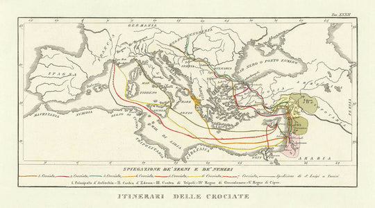


Antica mappa delle Crociate di Marmocchi, 1838: Itinerari, Gerusalemme, Antiochia, Costantinopoli

-
![]() Handmade in the USA
Handmade in the USA
-
FREE worldwide delivery in 2-3 days ⓘ
Free delivery in 2-3 days
Your map should be delivered in 2-3 working days with free delivery, worldwide.
We make maps by hand locally in 23 countries. If you're buying a gift for someone in another country, we will make the map locally to them.
You will never pay import tax or customs duty.
Express delivery is available at checkout which can reduce the delivery time to 1-2 days.
Please note that personalised maps, and larger framed maps, can take longer to produce and deliver.
If you need your order to arrive by a certain date, contact me and we can discuss your options.
-
90 day money back guarantee
ⓘ
90 giorni per restituire e ottenere un rimborso
I prodotti possono essere restituiti entro 90 giorni per un rimborso completo, o scambio con un altro prodotto.
Per articoli personalizzati o su misura, potremmo offrirti un credito in negozio o una carta regalo non scadente, poiché non possiamo rivendere ordini personalizzati.
Se hai domande, contattaci. Per ulteriori informazioni, consulta la nostra politica di restituzione e scambio.

My maps are rare, museum-grade, restored old maps sourced from libraries, auction houses and private collections across the globe.
Framing & free personalisation available
1. Select your size
2. Frame & personalize your map
Make your map unique with framing, hand-drawn customisation, vintage ageing, pop art text, unique 3D styling and moreGift message & custom finish

If you want to add a gift message, or a finish (jigsaw, aluminium board, etc.) that is not available here, please request it in the "order note" when you check out.
Every order is custom made, so if you need the size adjusted slightly, or printed on an unusual material, just let us know. We've done thousands of custom orders over the years, so there's (almost) nothing we can't manage.
You can also contact us before you order, if you prefer!

- Handmade locally. No import duty or tax
- FREE Delivery. Arrives in 2-3 days
- Love it or your money back
- Questions? WhatsApp me any time
Own a piece of history
5,000+ 5 star reviews


Entra nella ricca trama della storia medievale con gli "Itinerari delle Crociate", una mappa affascinante realizzata dal noto geografo italiano Francesco Marmocchi nel 1838. Questo pezzo squisito offre una finestra sull'era tumultuosa delle Crociate, tracciando i percorsi delle forze cristiane mentre intraprendevano le loro sacre missioni per riconquistare Gerusalemme. Ogni rotta è meticolosamente tracciata, rivelando i viaggi strategici terrestri e marittimi che hanno definito questo periodo. I dettagli intricati della mappa sui regni e le regioni del Medio Oriente offrono uno sguardo affascinante sul panorama geopolitico dell'epoca.
Esplorando questa mappa, scoprirai i percorsi seguiti dai crociati, provenienti da varie parti d'Europa, come il Regno d'Ungheria, e attraversando il Mare Mediterraneo. La mappa evidenzia l'importanza strategica di città chiave come Roma, Costantinopoli e Gerusalemme, che hanno servito come punti cruciali nei viaggi dei crociati. L'inclusione di rotte sia terrestri che marittime sottolinea la complessità e la scala di queste campagne militari medievali, offrendo una visione completa delle sfide logistiche delle Crociate.
Gli "Itinerari delle Crociate" non sono semplicemente una rappresentazione geografica ma una narrazione di ambizione, fede e conflitto. Delineano i territori e i principati che hanno giocato ruoli cruciali durante le Crociate, come il Principato di Antiochia e il Regno di Gerusalemme. Queste regioni, segnate con precisione, riflettono le alleanze in cambiamento e le dinamiche di potere che hanno caratterizzato il Medio Oriente medievale. La mappa traccia anche l'espedizione di San Luigi in Tunisia, aggiungendo un ulteriore strato di intrigo storico a questo già affascinante artefatto.
La mappa di Marmocchi è una testimonianza del fascino duraturo delle Crociate, una serie di guerre religiose che hanno lasciato un segno indelebile sia sulla storia europea che su quella del Medio Oriente. La cartografia dettagliata cattura l'essenza di un'epoca passata, in cui fede e ambizione spingevano gli uomini a percorrere vaste distanze in cerca dei loro obiettivi sacri. Questa mappa serve da promemoria dell'interconnessione tra passato e presente, illustrando come gli eventi storici continuino a plasmare la nostra comprensione del mondo.
Oltre al suo significato storico, l'appeal estetico della mappa è innegabile. Il design elegante e la cura nella delineazione di regioni come la Francia, la Germania e la Spagna, insieme alla rappresentazione del Mar Nero, creano un pezzo visivamente straordinario che sarebbe un'aggiunta preziosa a qualsiasi collezione. Che tu sia un appassionato di storia o un amante della bella cartografia, gli "Itinerari delle Crociate" offrono un'opportunità unica di possedere un pezzo di storia che è tanto informativo quanto bello.
Luoghi su questa mappa
- Roma
- Costantinopoli
- Gerusalemme
- Antiochia
- Tripoli
- Edessa
- Cipro
- Damasco
- Ungheria
- Francia
- Germania
- Spagna
- Mar Nero o Ponto Eusino (Black Sea)
- Egitto
- Arabia
- Mauritania
- Numidia
- Regno di Napoli
- Regno di Cipro
Caratteristiche & Luoghi Notabili
- Rotte delle sette Crociate
- Rotte terrestri e marittime dall'Europa alla Terra Santa
- Regni e regioni del Medio Oriente, come il Principato di Antiochia e il Regno di Gerusalemme
- Il Mare Mediterraneo come una rotta principale per i crociati
- Il Regno d'Ungheria come punto di partenza per le rotte terrestri
- Città chiave come Roma, Costantinopoli e Gerusalemme
- La delimitazione dei territori in Medio Oriente durante le Crociate
- Il percorso dell'espedizione di San Luigi verso Tunisi
- Le regioni segnate di Francia, Germania e Spagna
- L'inclusione del Mar Nero (Mar Nero o Ponto Eusino)
Contesto storico e di design
- Nome della mappa: Itinerari delle Crociate
- Data di creazione: 1838
- Cartografo/Editore: Francesco Marmocchi
- La mappa si concentra sulle rotte delle sette Crociate, evidenziando i percorsi seguiti dalle forze cristiane verso la Terra Santa.
- Presenta una panoramica geografica del Medioevo, dettagliando le rotte dall'Europa a Gerusalemme.
- La mappa è una mappa storica tematica, che mostra rotte dettagliate e confini geografici dell'epoca.
- Questa mappa offre un'idea sulle Crociate, una serie di guerre religiose durante il periodo medievale, e il loro impatto sulla storia europea e mediorientale.
Si prega di controllare attentamente le immagini per assicurarsi che una specifica città o luogo sia mostrato su questa mappa. Puoi anche contattarci e chiedere di controllare la mappa per te.
Questa mappa appare fantastica in ogni dimensione, ma consiglio sempre di optare per una dimensione più grande se hai spazio. In questo modo puoi facilmente distinguere tutti i dettagli.
Questa mappa appare sorprendente in dimensioni fino a 50 pollici (125 cm). Se stai cercando una mappa più grande, ti preghiamo di contattarci.
Questa mappa è più larga della maggior parte delle mappe, il che la renderebbe un pezzo d'arredo perfetto sopra un camino, un divano o una scrivania.
La quinta immagine dell'elenco mostra un esempio del mio servizio di personalizzazione della mappa.
Se stai cercando qualcosa di leggermente diverso, dai un'occhiata alla mia collezione delle migliori mappe antiche per vedere se qualcosa attira la tua attenzione.
Per favore contattami per verificare se una certa posizione, punto di riferimento o caratteristica è mostrato su questa mappa.
Questo sarebbe un meraviglioso regalo per un compleanno, Natale, Festa del Papà, partenza dal lavoro, anniversario o inaugurazione della casa per qualcuno delle aree coperte da questa mappa.
Questa mappa è disponibile come stampa giclée su carta opaca archiviata senza acidi, oppure puoi acquistarla incorniciata. La cornice è una semplice cornice nera che si adatta alla maggior parte degli stili. Ti preghiamo di contattarci se desideri un colore o un materiale di cornice diverso. Le mie cornici sono dotate di un acrilico (perspex/acrylite) super chiaro di grado museale, che è significativamente meno riflettente del vetro, più sicuro e arriverà sempre in perfette condizioni.
This map is also available as a float framed canvas, sometimes known as a shadow gap framed canvas or canvas floater. The map is printed on artist's cotton canvas and then stretched over a handmade box frame. We then "float" the canvas inside a wooden frame, which is available in a range of colours (black, dark brown, oak, antique gold and white). This is a wonderful way to present a map without glazing in front. See some examples of float framed canvas maps and explore the differences between my different finishes.
For something truly unique, this map is also available in "Unique 3D", our trademarked process that dramatically transforms the map so that it has a wonderful sense of depth. We combine the original map with detailed topography and elevation data, so that mountains and the terrain really "pop". For more info and examples of 3D maps, check my Unique 3D page.
For most orders, delivery time is about 3 working days. Personalised and customised products take longer, as I have to do the personalisation and send it to you for approval, which usually takes 1 or 2 days.
Please note that very large framed orders usually take longer to make and deliver.
If you need your order to arrive by a certain date, please contact me before you order so that we can find the best way of making sure you get your order in time.
I print and frame maps and artwork in 23 countries around the world. This means your order will be made locally, which cuts down on delivery time and ensures that it won't be damaged during delivery. You'll never pay customs or import duty, and we'll put less CO2 into the air.
All of my maps and art prints are well packaged and sent in a rugged tube if unframed, or surrounded by foam if framed.
I try to send out all orders within 1 or 2 days of receiving your order, though some products (like face masks, mugs and tote bags) can take longer to make.
If you select Express Delivery at checkout your order we will prioritise your order and send it out by 1-day courier (Fedex, DHL, UPS, Parcelforce).
Next Day delivery is also available in some countries (US, UK, Singapore, UAE) but please try to order early in the day so that we can get it sent out on time.
My standard frame is a gallery style black ash hardwood frame. It is simple and quite modern looking. My standard frame is around 20mm (0.8in) wide.
I use super-clear acrylic (perspex/acrylite) for the frame glass. It's lighter and safer than glass - and it looks better, as the reflectivity is lower.
Six standard frame colours are available for free (black, dark brown, dark grey, oak, white and antique gold). Custom framing and mounting/matting is available if you're looking for something else.
Most maps, art and illustrations are also available as a framed canvas. We use matte (not shiny) cotton canvas, stretch it over a sustainably sourced box wood frame, and then 'float' the piece within a wood frame. The end result is quite beautiful, and there's no glazing to get in the way.
All frames are provided "ready to hang", with either a string or brackets on the back. Very large frames will have heavy duty hanging plates and/or a mounting baton. If you have any questions, please get in touch.
See some examples of my framed maps and framed canvas maps.
Alternatively, I can also supply old maps and artwork on canvas, foam board, cotton rag and other materials.
If you want to frame your map or artwork yourself, please read my size guide first.
Alcune delle mie vecchie mappe sono ora disponibili come tele incorniciate. Per favore contattami se desideri ordinare una dimensione che non è disponibile nel mio negozio.
Le vecchie mappe su tela sono un'alternativa interessante alle mappe incorniciate in modo convenzionale. A seconda del tuo gusto personale e dell'arredamento della stanza, le mappe su tela possono "risaltare" un po' di più rispetto a una mappa incorniciata.
My maps are extremely high quality reproductions of original maps.
I source original, rare maps from libraries, auction houses and private collections around the world, restore them at my London workshop, and then use specialist giclée inks and printers to create beautiful maps that look even better than the original.
My maps are printed on acid-free archival matte (not glossy) paper that feels very high quality and almost like card. In technical terms the paper weight/thickness is 10mil/200gsm. It's perfect for framing.
I print with Epson ultrachrome giclée UV fade resistant pigment inks - some of the best inks you can find.
I can also make maps on canvas, cotton rag and other exotic materials.
Learn more about The Unique Maps Co.
Map personalisation
If you're looking for the perfect anniversary or housewarming gift, I can personalise your map to make it truly unique. For example, I can add a short message, or highlight an important location, or add your family's coat of arms.
The options are almost infinite. Please see my map personalisation page for some wonderful examples of what's possible.
To order a personalised map, select "personalise your map" before adding it to your basket.
Get in touch if you're looking for more complex customisations and personalisations.
Map ageing
I have been asked hundreds of times over the years by customers if they could buy a map that looks even older.
Well, now you can, by selecting Aged before you add a map to your basket.
All the product photos you see on this page show the map in its Original form. This is what the map looks like today.
If you select Aged, I will age your map by hand, using a special and unique process developed through years of studying old maps, talking to researchers to understand the chemistry of aging paper, and of course... lots of practice!
If you're unsure, stick to the Original colour of the map. If you want something a bit darker and older looking, go for Aged.
Se non sei soddisfatto del tuo ordine per qualsiasi motivo, contattami per un rimborso senza problemi. Si prega di consultare la nostra politica di reso e rimborso per ulteriori informazioni.
Sono molto sicuro che ti piacerà la tua mappa restaurata o la stampa d'arte. Lo faccio dal 1984. Sono un venditore Etsy a 5 stelle. Ho venduto decine di migliaia di mappe e stampe d'arte e ho oltre 5.000 recensioni reali a 5 stelle.
Utilizzo un processo unico per restaurare mappe e opere d'arte che richiede molto tempo e lavoro. Trovare le mappe e le illustrazioni originali può richiedere mesi. Utilizzo tecnologia all'avanguardia e incredibilmente costosa per scannerizzare e restaurarle. Di conseguenza, garantisco che le mie mappe e stampe d'arte siano superiori alle altre - ecco perché posso offrire un rimborso senza problemi.
Quasi tutte le mie mappe e stampe d'arte sembrano fantastiche a grandi dimensioni (200 cm, 6,5 piedi+) e posso anche incorniciarle e consegnarle a te, tramite un corriere speciale per oggetti di grandi dimensioni. Contattami per discutere delle tue esigenze specifiche.
Or try searching for something!


