


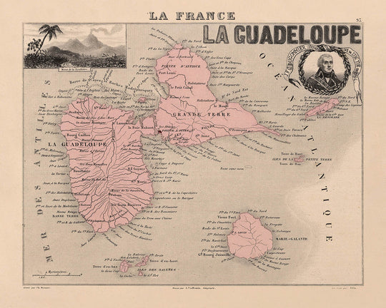


Antica mappa della Guadalupa di Vuillemin, 1869: Pointe-à-Pitre, Basse-Terre, Grande-Terre, Marie-Galante, canna da zucchero
Christmas Express Delivery
You can order up until 10am on December 22 with Express Delivery to receive your order by Christmas.
Unframed products are much more likely to arrive by Christmas. Framed products may arrive on time, but they move more slowly, particularly when couriers are so overloaded with packages.
Personalised orders are unlikely to arrive on time (but if you absolutely must have a personalised product, please contact me and I'll do my best to help!)
Contact me for info on last-minute deliveries.
Spend $300, Save $60 Christmas Express Delivery available
Christmas Express Delivery
You can order up until 10am on December 22 with Express Delivery to receive your order by Christmas.
Unframed products are much more likely to arrive by Christmas. Framed products may arrive on time, but they move more slowly, particularly when couriers are so overloaded with packages.
Personalised orders are unlikely to arrive on time (but if you absolutely must have a personalised product, please contact me and I'll do my best to help!)
Contact me for info on last-minute deliveries.
Spend $300, Save $60

-
![]() Handmade in the USA
Handmade in the USA
-
FREE delivery in 3-4 days ⓘ
Free delivery in 3-4 days
Your map should be delivered in 3-4 working days with free delivery, worldwide.
Please use Express Delivery at checkout for Christmas orders. Framed orders may arrive with Express Delivery, but it is not guaranteed.
New for 2025: After you order, you can send a beautiful gift preview by email, if you're worried it won't arrive on time.
We make maps by hand locally in 23 countries. If you're buying a gift for someone in another country, we will make the map locally to them.
You will never pay import tax or customs duty.
Check the Christmas delivery guide for order deadlines. Delivery times are starting to slow down, and will continue to slow down towards Christmas.
Express delivery is available at checkout which can reduce the delivery time to 1-2 days.
Please note that personalised maps, and larger framed maps, can take longer to produce and deliver.
If you need your order to arrive by a certain date, contact me and we can discuss your options.
-
FREE gift preview
ⓘ
Digital gift preview
New for 2025: After you complete your order, you can send a beautiful digital preview to the gift recipient. Just provide their email address and we'll do the rest. (Their email address will not be stored or used for any other purpose.)
This is perfect for Christmas gifting, particularly if you're concerned that your order might not arrive in time for Christmas.
-
90 day money back guarantee
ⓘ
90 giorni per restituire e ricevere un rimborso
I prodotti possono essere restituiti entro 90 giorni per un rimborso completo, o cambio con un altro prodotto.
Per articoli personalizzati e su misura, potremmo offrirti un credito in negozio o una carta regalo non scadente, poiché non possiamo rivendere ordini personalizzati.
Se hai domande, contattaci. Per ulteriori informazioni, consulta la nostra politica di restituzione e cambio.

My maps are rare, museum-grade, restored old maps sourced from libraries, auction houses and private collections across the globe.
Framing & free personalisation available
1. Select your size
2. Frame & personalize your map
There is limited framing & personalisation capacity available. Order by 10am tomorrow for Christmas delivery.


Gift message & custom finish

If you want to add a gift message, or a finish (jigsaw, aluminium board, etc.) that is not available here, please request it in the "order note" when you check out.
Every order is custom made, so if you need the size adjusted slightly, or printed on an unusual material, just let us know. We've done thousands of custom orders over the years, so there's (almost) nothing we can't manage.
You can also contact us before you order, if you prefer!

- Handmade locally. No import duty or tax
- FREE Delivery by Christmas
- Love it or your money back (90 days)
- Questions? WhatsApp me any time
Own a piece of history
5,000+ 5 star reviews


Entra nella vivida storia dei Caraibi con "La Guadeloupe", una squisita mappa del 1869 realizzata dal rinomato cartografo francese A. Vuillemin. Con il suo titolo originale francese, questa mappa cattura l'essenza della Guadalupa in un momento cruciale del suo passato coloniale. I dettagliati confini politici e la precisa delineazione delle isole—Grande-Terre, Basse-Terre, Marie-Galante, Les Saintes e La Désirade—invita lo spettatore a esplorare un mondo plasmato sia dalla natura che dall'impegno umano.
L'arte di A. Vuillemin brilla attraverso il design sontuoso della mappa, che accoppia una cartografia accurata con decorazioni elaborate. Attorno alla mappa ci sono vignette affascinanti: scene di lavoratori agricoli che raccolgono canna da zucchero, caffè e banane, e illustrazioni della lussureggiante flora e della fauna distintiva dell'isola. Questi abbellimenti non solo abbelliscono—raccontano la storia del sangue economico della Guadalupa e della sua ricca biodiversità, immergendo lo spettatore nei luoghi e nelle attività che definivano la vita quotidiana della colonia.
La mappa fa parte di una collezione prestigiosa che fonde splendore visivo con dettagli accademici. Ogni mappa di questa serie era accompagnata da un testo descrittivo, fornendo statistiche preziose e collocando la regione all'interno della geografia più ampia della Francia facendo riferimento a distanze e direzioni da Parigi. Questo approccio duale non solo soddisfaceva la curiosità degli studiosi e dei collezionisti del XIX secolo, ma forniva anche un'istantanea completa dell'importanza della colonia all'interno dell'Impero Francese. L'inclusione di stemmi e altri simboli araldici sottolinea ulteriormente lo status e l'identità della Guadalupa durante quest'epoca.
Un esame più attento rivela un arazzo di insediamenti che hanno plasmato la storia della Guadalupa. Dal vivace porto di Pointe-à-Pitre al cuore amministrativo di Basse-Terre, e dal fascino costiero di Sainte-Anne alle terre fertili di Capesterre e Le Moule, la mappa cronaca l'emergere di città che rimangono vitali oggi. Questi nomi, accuratamente incisi, evocano il passato stratificato dell'isola e l'eredità duratura delle sue comunità. La chiarezza della mappa e l'attenzione ai dettagli degli insediamenti la rendono una risorsa preziosa per storici ed appassionati.
Storicamente, "La Guadeloupe" si erge come un testamento all'incrocio tra ambizione coloniale, cultura locale e bellezza naturale. Offre uno sguardo raro sul panorama politico ed economico della Guadalupa alla fine del XIX secolo, illuminando le forze che hanno plasmato il suo sviluppo. Che venga ammirata per la sua arte, studiata per le sue informazioni, o apprezzata come un artefatto culturale, questa mappa è una finestra straordinaria su un mondo in cui geografia, storia e aspirazione umana si convergono.
Città e paesi su questa mappa
- Pointe-à-Pitre
- Basse-Terre
- Sainte-Anne
- Le Moule
- Capesterre
- Trois-Rivières
- Port-Louis
- Saint-François
- Petit-Bourg
- Baillif
- Deshaies
- Pointe-Noire
- Vieux-Habitants
- Gourbeyre
- Goyave
- Lamentin
- Sainte-Rose
- Morne-à-l'Eau
- Anse-Bertrand
- Grand-Bourg (Marie-Galante)
Caratteristiche e punti di riferimento notevoli
- Vignette artistiche che raffigurano prodotti agricoli locali, come canna da zucchero, caffè e banane
- Illustrazioni di scene locali, inclusi lavoratori agricoli e attività di piantagione
- Rappresentazione della flora e fauna locali, enfatizzando la biodiversità della Guadalupa
- Stemma decorativo o emblemi che rappresentano la colonia
- Chiara delineazione delle isole che compongono la Guadalupa: Grande-Terre, Basse-Terre, Marie-Galante, Les Saintes e La Désirade
- Rappresentazione delle rotte marittime e delle caratteristiche costiere, evidenziando l'importanza del commercio marittimo e della navigazione
Contesto storico e di design
- Creato nel 1869 da A. Vuillemin, un rinomato cartografo francese del XIX secolo noto per mappe dettagliate e decorative
- Mappa politica dettagliata che riflette la prospettiva coloniale e le divisioni amministrative della Guadalupa alla fine del XIX secolo
- Parte di una collezione distinta che abbina mappe con testo descrittivo, fornendo statistiche e contesto geografico relativo a Parigi
- Progettato per essere sia informativo che esteticamente gradevole, adatto per scopi educativi e di esposizione
- Offre un'idea della vita economica e culturale della colonia, evidenziando l'agricoltura e i prodotti commerciali importanti dell'epoca
- Fornisce uno sguardo raro sul panorama politico ed economico della Guadalupa durante l'era coloniale francese
Si prega di controllare attentamente le immagini per assicurarsi che una specifica città o luogo sia mostrato su questa mappa. Puoi anche contattarci e chiedere di controllare la mappa per te.
Questa mappa appare fantastica in ogni dimensione, ma consiglio sempre di optare per una dimensione più grande se hai spazio. In questo modo puoi facilmente distinguere tutti i dettagli.
Questa mappa appare incredibile in dimensioni fino a 50 pollici (125 cm). Se stai cercando una mappa più grande, ti preghiamo di contattarci.
Il modello nelle immagini dell'elenco tiene la versione 16x20 pollici (40x50 cm) di questa mappa.
La quinta immagine dell'elenco mostra un esempio del mio servizio di personalizzazione della mappa.
Se stai cercando qualcosa di leggermente diverso, dai un'occhiata alla mia collezione delle migliori vecchie mappe per vedere se qualcosa altro cattura la tua attenzione.
Per favore contattami per verificare se una certa posizione, punto di riferimento o caratteristica è mostrata su questa mappa.
Questa sarebbe una meravigliosa idea regalo per compleanno, Natale, festa del papà, partenza dal lavoro, anniversario o inaugurazione della casa per qualcuno delle aree coperte da questa mappa.
Questa mappa è disponibile come stampa giclée su carta opaca archivistica priva di acidi, oppure puoi acquistarla incorniciata. La cornice è una bella e semplice cornice nera che si adatta alla maggior parte degli stili. Ti preghiamo di contattarci se desideri un colore o un materiale di cornice diverso. Le mie cornici sono vetriate con acrilico super chiaro di grado museale (perspex/acrylite), che è significativamente meno riflettente del vetro, più sicuro e arriverà sempre in condizioni perfette.
This map is also available as a float framed canvas, sometimes known as a shadow gap framed canvas or canvas floater. The map is printed on artist's cotton canvas and then stretched over a handmade box frame. We then "float" the canvas inside a wooden frame, which is available in a range of colours (black, dark brown, oak, antique gold and white). This is a wonderful way to present a map without glazing in front. See some examples of float framed canvas maps and explore the differences between my different finishes.
For something truly unique, this map is also available in "Unique 3D", our trademarked process that dramatically transforms the map so that it has a wonderful sense of depth. We combine the original map with detailed topography and elevation data, so that mountains and the terrain really "pop". For more info and examples of 3D maps, check my Unique 3D page.
For most orders, delivery time is about 3 working days. Personalised and customised products take longer, as I have to do the personalisation and send it to you for approval, which usually takes 1 or 2 days.
Please note that very large framed orders usually take longer to make and deliver.
If you need your order to arrive by a certain date, please contact me before you order so that we can find the best way of making sure you get your order in time.
I print and frame maps and artwork in 23 countries around the world. This means your order will be made locally, which cuts down on delivery time and ensures that it won't be damaged during delivery. You'll never pay customs or import duty, and we'll put less CO2 into the air.
All of my maps and art prints are well packaged and sent in a rugged tube if unframed, or surrounded by foam if framed.
I try to send out all orders within 1 or 2 days of receiving your order, though some products (like face masks, mugs and tote bags) can take longer to make.
If you select Express Delivery at checkout your order we will prioritise your order and send it out by 1-day courier (Fedex, DHL, UPS, Parcelforce).
Next Day delivery is also available in some countries (US, UK, Singapore, UAE) but please try to order early in the day so that we can get it sent out on time.
My standard frame is a gallery style black ash hardwood frame. It is simple and quite modern looking. My standard frame is around 20mm (0.8in) wide.
I use super-clear acrylic (perspex/acrylite) for the frame glass. It's lighter and safer than glass - and it looks better, as the reflectivity is lower.
Six standard frame colours are available for free (black, dark brown, dark grey, oak, white and antique gold). Custom framing and mounting/matting is available if you're looking for something else.
Most maps, art and illustrations are also available as a framed canvas. We use matte (not shiny) cotton canvas, stretch it over a sustainably sourced box wood frame, and then 'float' the piece within a wood frame. The end result is quite beautiful, and there's no glazing to get in the way.
All frames are provided "ready to hang", with either a string or brackets on the back. Very large frames will have heavy duty hanging plates and/or a mounting baton. If you have any questions, please get in touch.
See some examples of my framed maps and framed canvas maps.
Alternatively, I can also supply old maps and artwork on canvas, foam board, cotton rag and other materials.
If you want to frame your map or artwork yourself, please read my size guide first.
Alcune delle mie vecchie mappe sono ora disponibili come tele incorniciate. Per favore contattami se desideri ordinare una dimensione che non è disponibile nel mio negozio.
Le vecchie mappe su tela sono un'alternativa interessante alle mappe incorniciate in modo convenzionale. A seconda del tuo gusto personale e dell'arredamento della stanza, le mappe su tela possono "risaltare" un po' di più rispetto a una mappa incorniciata.
My maps are extremely high quality reproductions of original maps.
I source original, rare maps from libraries, auction houses and private collections around the world, restore them at my London workshop, and then use specialist giclée inks and printers to create beautiful maps that look even better than the original.
My maps are printed on acid-free archival matte (not glossy) paper that feels very high quality and almost like card. In technical terms the paper weight/thickness is 10mil/200gsm. It's perfect for framing.
I print with Epson ultrachrome giclée UV fade resistant pigment inks - some of the best inks you can find.
I can also make maps on canvas, cotton rag and other exotic materials.
Learn more about The Unique Maps Co.
Map personalisation
If you're looking for the perfect anniversary or housewarming gift, I can personalise your map to make it truly unique. For example, I can add a short message, or highlight an important location, or add your family's coat of arms.
The options are almost infinite. Please see my map personalisation page for some wonderful examples of what's possible.
To order a personalised map, select "personalise your map" before adding it to your basket.
Get in touch if you're looking for more complex customisations and personalisations.
Map ageing
I have been asked hundreds of times over the years by customers if they could buy a map that looks even older.
Well, now you can, by selecting Aged before you add a map to your basket.
All the product photos you see on this page show the map in its Original form. This is what the map looks like today.
If you select Aged, I will age your map by hand, using a special and unique process developed through years of studying old maps, talking to researchers to understand the chemistry of aging paper, and of course... lots of practice!
If you're unsure, stick to the Original colour of the map. If you want something a bit darker and older looking, go for Aged.
Se non sei soddisfatto del tuo ordine per qualsiasi motivo, contattami per un rimborso senza problemi. Si prega di consultare la nostra politica di reso e rimborso per ulteriori informazioni.
Sono molto sicuro che ti piacerà la tua mappa restaurata o la stampa d'arte. Lo faccio dal 1984. Sono un venditore Etsy a 5 stelle. Ho venduto decine di migliaia di mappe e stampe d'arte e ho oltre 5.000 recensioni reali a 5 stelle.
Utilizzo un processo unico per restaurare mappe e opere d'arte che richiede molto tempo e lavoro. Trovare le mappe e le illustrazioni originali può richiedere mesi. Utilizzo tecnologia all'avanguardia e incredibilmente costosa per scannerizzare e restaurarle. Di conseguenza, garantisco che le mie mappe e stampe d'arte siano superiori alle altre - ecco perché posso offrire un rimborso senza problemi.
Quasi tutte le mie mappe e stampe d'arte sembrano fantastiche a grandi dimensioni (200 cm, 6,5 piedi+) e posso anche incorniciarle e consegnarle a te, tramite un corriere speciale per oggetti di grandi dimensioni. Contattami per discutere delle tue esigenze specifiche.
Or try searching for something!


