

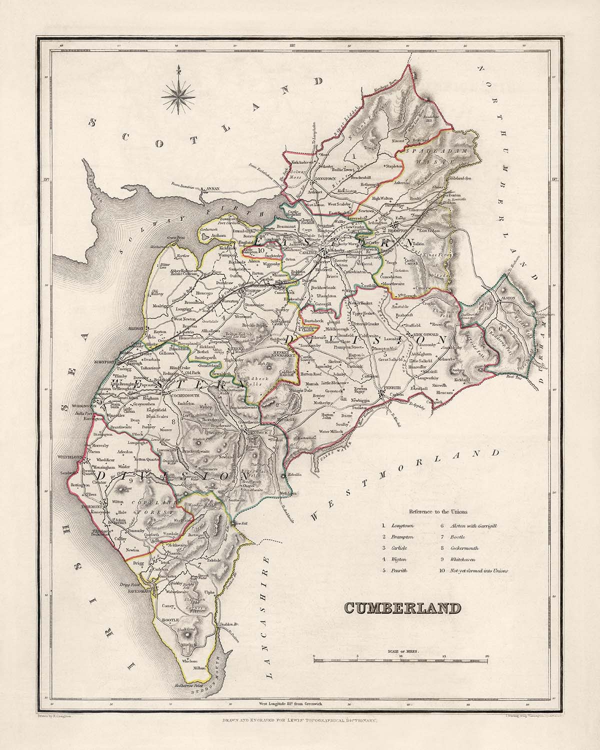


Antica mappa del Cumberland di Samuel Lewis, 1844: Carlisle, Whitehaven, Workington, Penrith e Keswick

-
![]() Handmade in the USA
Handmade in the USA
-
FREE Christmas delivery: check the deadline
Free delivery in 3-4 days
Your map should be delivered in 3-4 working days with free delivery, worldwide.
Free delivery may arrive on time, but Express Delivery at checkout is safer. Unframed orders have a better chance of arriving in time with free delivery.
New for 2025: After you order, you can send a beautiful gift preview by email, if you're worried it won't arrive on time.
We make maps by hand locally in 23 countries. If you're buying a gift for someone in another country, we will make the map locally to them.
You will never pay import tax or customs duty.
Check the Christmas delivery guide for order deadlines. Delivery times are starting to slow down, and will continue to slow down towards Christmas.
Express delivery is available at checkout which can reduce the delivery time to 1-2 days.
Please note that personalised maps, and larger framed maps, can take longer to produce and deliver.
If you need your order to arrive by a certain date, contact me and we can discuss your options.
-
90 day money back guarantee
ⓘ
90 giorni per restituire e ricevere un rimborso
I prodotti possono essere restituiti entro 90 giorni per un rimborso completo, o cambio con un altro prodotto.
Per articoli personalizzati e su misura, potremmo offrirti un credito in negozio o una carta regalo non scadente, poiché non possiamo rivendere ordini personalizzati.
Se hai domande, contattaci. Per ulteriori informazioni, consulta la nostra politica di restituzione e cambio.

My maps are rare, museum-grade, restored old maps sourced from libraries, auction houses and private collections across the globe.
Framing & free personalisation available
1. Select your size
2. Frame & personalize your map
There is limited framing & personalisation capacity available. Order by 10am tomorrow for Christmas delivery.


Gift message & custom finish

If you want to add a gift message, or a finish (jigsaw, aluminium board, etc.) that is not available here, please request it in the "order note" when you check out.
Every order is custom made, so if you need the size adjusted slightly, or printed on an unusual material, just let us know. We've done thousands of custom orders over the years, so there's (almost) nothing we can't manage.
You can also contact us before you order, if you prefer!

- Handmade locally. No import duty or tax
- FREE Delivery by Christmas
- Love it or your money back (90 days)
- Questions? WhatsApp me any time
Own a piece of history
5,000+ 5 star reviews


La "Vecchia Mappa di Cumberland di Samuel Lewis, 1844" è una mappa affascinante e storicamente significativa che offre uno sguardo nel passato. Realizzata da Samuel Lewis nel 1844, questa mappa mostra la Contea di Cumberland in Inghilterra durante un periodo di grande cambiamento ed esplorazione. Presenta un'opportunità unica per esplorare la ricca storia della regione e apprezzare la bellezza dell'arte cartografica.
Questa mappa ha un particolare fascino grazie alla sua rappresentazione delle principali città, paesi e altre caratteristiche affascinanti che erano presenti a Cumberland durante la metà del XIX secolo. È importante notare che alcune città moderne potrebbero non essere incluse in questa mappa, mentre altre potrebbero apparire con nomi precedenti, aggiungendo un elemento di intrigo e scoperta. Possedendo questa mappa, puoi immergerti nel contesto storico della regione e assistere alla sua evoluzione nel tempo.
Nota per la sua attenzione ai dettagli, questa mappa mostra i confini storici di Cumberland, Inghilterra. Per fornire ulteriori informazioni sul passato della regione, abbiamo compilato un elenco completo di 30 insediamenti, città e contee notevoli che furono fondati prima del 1840 e si trovavano all'interno dei confini storici della Contea di Cumberland. Ogni voce è accompagnata da una breve descrizione che evidenzia la sua importanza e l'anno in cui è stata fondata. Questo elenco è ordinato meticolosamente per dimensione della popolazione moderna, garantendo un'esplorazione completa della prominenza storica della regione.
Insediamenti e Contee Notevoli Fondati Prima del 1840:
- Carlisle (71.773 abitanti): Fondata dai Romani nel I secolo d.C., Carlisle è ricca di storia, con un castello medievale e una cattedrale ben conservati.
- Whitehaven (23.986 abitanti): Fondata nel 1660, Whitehaven ha svolto un ruolo vitale nell'industria mineraria del carbone durante il XVIII secolo, lasciando un'eredità di patrimonio industriale.
- Workington (19.491 abitanti): Con radici che risalgono all'epoca romana, Workington divenne un importante centro per la produzione di ferro e acciaio durante la Rivoluzione Industriale.
- Penrith (15.985 abitanti): Nota per il suo imponente castello e la sua posizione strategica lungo il percorso storico tra Scozia e Inghilterra, Penrith ha una ricca storia che risale ai tempi pre-romani.
- Keswick (5.243 abitanti): Immersa nel meraviglioso Parco Nazionale del Lake District, Keswick è stata una popolare destinazione turistica sin dal XVIII secolo, rinomata per i suoi paesaggi pittoreschi e le attività all'aperto.
[...]
Si prega di notare che l'elenco continua con 25 ulteriori insediamenti, città e contee notevoli fondati prima del 1840, ciascuno con la propria importanza storica.
Confini, Fiumi e Fenomeni Naturali Notevoli:
- Il Muro di Adriano: Un Sito Patrimonio dell'Umanità dell'UNESCO, il Muro di Adriano servì come frontiera settentrionale dell'Impero Romano, estendendosi attraverso la regione e offrendo uno sguardo nella storia antica.
- Parco Nazionale del Lake District: Famoso per i suoi paesaggi mozzafiato, il Parco Nazionale del Lake District comprende laghi pittoreschi, colline ondulate e affascinanti villaggi, offrendo infinite opportunità di esplorazione.
Eventi Storici a Cumberland, Inghilterra (1800-1850):
- 1801: La popolazione di Cumberland fu registrata come 192.877 nel primo censimento moderno.
- 1817: Il Canale di Carlisle è stato inaugurato, collegando Carlisle al Solway Firth e facilitando il commercio e il trasporto.
- 1837: La regina Vittoria è salita al trono, segnando l'inizio dell'era vittoriana, che avrebbe influenzato notevolmente lo sviluppo della regione.
Immergiti nella ricca storia della Cumberland, Inghilterra, con la "Mappa Antica della Cumberland di Samuel Lewis, 1844." Questa mappa meticolosamente realizzata funge da porta d'accesso al passato, permettendoti di esplorare i confini storici della regione, i luoghi notevoli e le affascinanti caratteristiche naturali. Che tu sia un appassionato di storia, un amante della cartografia, o semplicemente apprezzi la bellezza di un'epoca passata, questa mappa è un'aggiunta straordinaria a qualsiasi collezione.
Ti preghiamo di controllare attentamente le immagini per assicurarti che una specifica città o luogo sia mostrato su questa mappa. Puoi anche contattarci e chiedere di controllare la mappa per te.
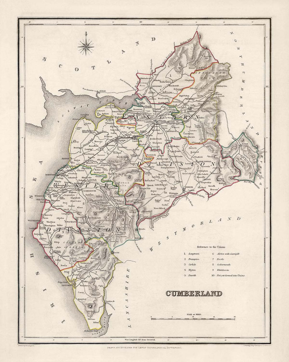
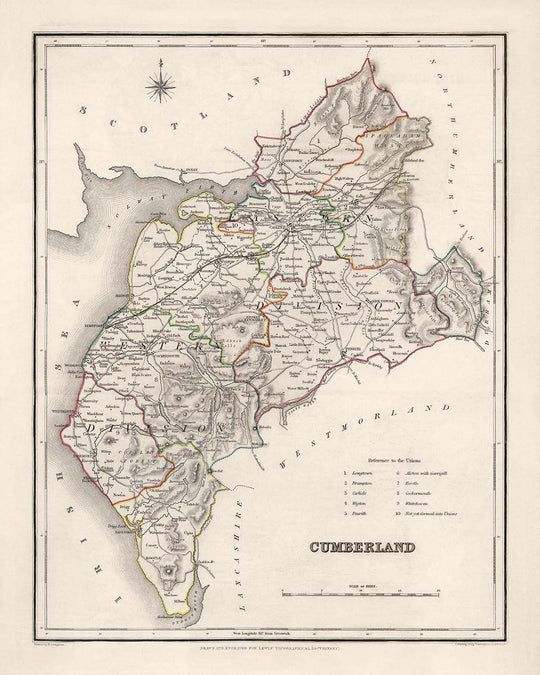
Questa mappa appare splendida in tutte le dimensioni: 12x16in (30.5x41cm), 16x20in (40.5x51cm), 18x24in (45.5x61cm), 24x30in (61x76cm), 32x40in (81.5x102cm) e 40x50in (102x127cm), ma appare ancora meglio se stampata in grande.
Posso creare stampe belle e grandi di questa mappa fino a 50in (127cm). Ti preghiamo di contattarci se stai cercando opzioni di incorniciatura più grandi, personalizzate o diverse.
Il modello nelle immagini dell'elenco sta tenendo la versione 16x20in (40.5x51cm) di questa mappa.
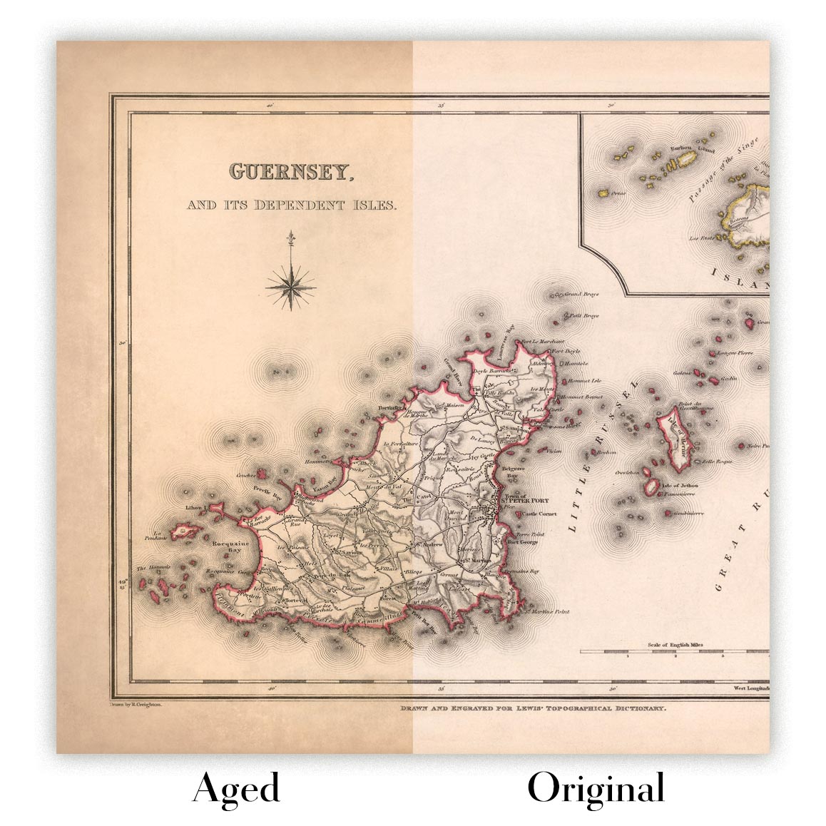
La quinta immagine dell'elenco mostra un esempio del mio servizio di personalizzazione della mappa.
Si prega di notare che la mappa non incorniciata 24x30in (61x76cm) ha bordi bianchi attorno alla mappa. Questi bordi possono aiutarti con l'incorniciatura, o se non ne hai bisogno, sono molto facili da tagliare con le forbici. Tutte le altre mappe, comprese le mappe incorniciate, sembrano esattamente come le immagini dell'elenco.
Se stai cercando qualcosa di leggermente diverso, dai un'occhiata alla mia principale collezione di mappe del Regno Unito e dell'Irlanda.
Ti preghiamo di contattarmi per controllare se una certa posizione, un punto di riferimento o una caratteristica è mostrata su questa mappa.
Questo sarebbe un meraviglioso regalo di compleanno, Natale, Festa del Papà, addio al lavoro, anniversario o per una festa di inaugurazione per qualcuno delle aree coperte da questa mappa.
Questa mappa è disponibile come stampa giclée su carta opaca archiviata senza acidi, oppure puoi acquistarla incorniciata. La cornice è una semplice cornice nera che si adatta alla maggior parte degli stili. Ti preghiamo di contattarci se desideri un colore o un materiale di cornice diverso. Le mie cornici sono dotate di un acrilico museo super chiaro (perspex/acrylite), che è significativamente meno riflettente del vetro, più sicuro e arriverà sempre in perfette condizioni.
This map is also available as a float framed canvas, sometimes known as a shadow gap framed canvas or canvas floater. The map is printed on artist's cotton canvas and then stretched over a handmade box frame. We then "float" the canvas inside a wooden frame, which is available in a range of colours (black, dark brown, oak, antique gold and white). This is a wonderful way to present a map without glazing in front. See some examples of float framed canvas maps and explore the differences between my different finishes.
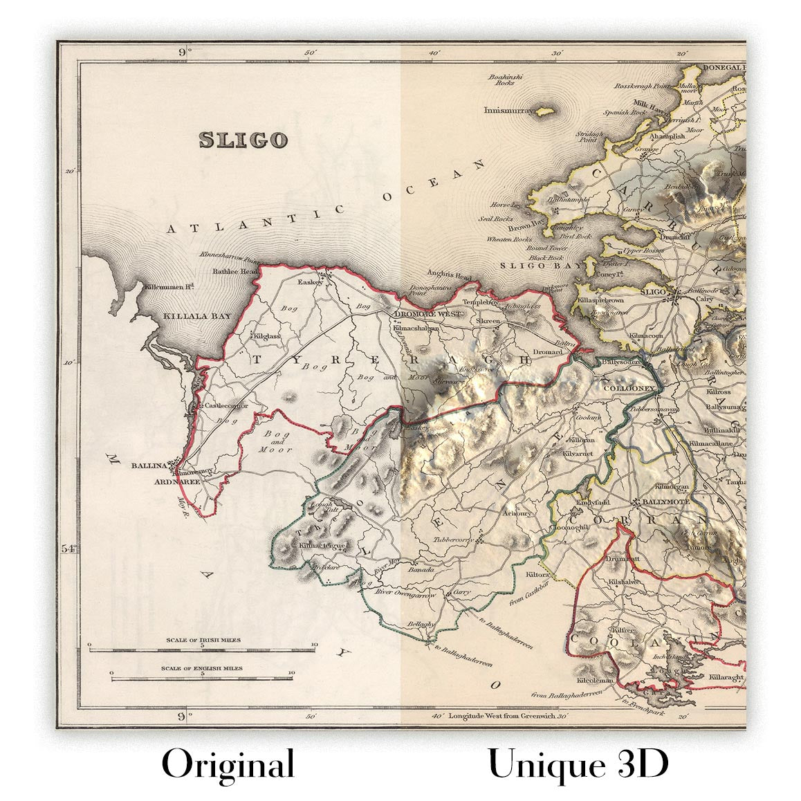
For something truly unique, this map is also available in "Unique 3D", our trademarked process that dramatically transforms the map so that it has a wonderful sense of depth. We combine the original map with detailed topography and elevation data, so that mountains and the terrain really "pop". For more info and examples of 3D maps, check my Unique 3D page.
For most orders, delivery time is about 3 working days. Personalised and customised products take longer, as I have to do the personalisation and send it to you for approval, which usually takes 1 or 2 days.
Please note that very large framed orders usually take longer to make and deliver.
If you need your order to arrive by a certain date, please contact me before you order so that we can find the best way of making sure you get your order in time.
I print and frame maps and artwork in 23 countries around the world. This means your order will be made locally, which cuts down on delivery time and ensures that it won't be damaged during delivery. You'll never pay customs or import duty, and we'll put less CO2 into the air.
All of my maps and art prints are well packaged and sent in a rugged tube if unframed, or surrounded by foam if framed.
I try to send out all orders within 1 or 2 days of receiving your order, though some products (like face masks, mugs and tote bags) can take longer to make.
If you select Express Delivery at checkout your order we will prioritise your order and send it out by 1-day courier (Fedex, DHL, UPS, Parcelforce).
Next Day delivery is also available in some countries (US, UK, Singapore, UAE) but please try to order early in the day so that we can get it sent out on time.
My standard frame is a gallery style black ash hardwood frame. It is simple and quite modern looking. My standard frame is around 20mm (0.8in) wide.
I use super-clear acrylic (perspex/acrylite) for the frame glass. It's lighter and safer than glass - and it looks better, as the reflectivity is lower.
Six standard frame colours are available for free (black, dark brown, dark grey, oak, white and antique gold). Custom framing and mounting/matting is available if you're looking for something else.
Most maps, art and illustrations are also available as a framed canvas. We use matte (not shiny) cotton canvas, stretch it over a sustainably sourced box wood frame, and then 'float' the piece within a wood frame. The end result is quite beautiful, and there's no glazing to get in the way.
All frames are provided "ready to hang", with either a string or brackets on the back. Very large frames will have heavy duty hanging plates and/or a mounting baton. If you have any questions, please get in touch.
See some examples of my framed maps and framed canvas maps.
Alternatively, I can also supply old maps and artwork on canvas, foam board, cotton rag and other materials.
If you want to frame your map or artwork yourself, please read my size guide first.
Alcune delle mie vecchie mappe sono ora disponibili come tele incorniciate. Per favore contattami se desideri ordinare una dimensione che non è disponibile nel mio negozio.
Le vecchie mappe su tela sono un'alternativa interessante alle mappe incorniciate in modo convenzionale. A seconda del tuo gusto personale e dell'arredamento della stanza, le mappe su tela possono "risaltare" un po' di più rispetto a una mappa incorniciata.
My maps are extremely high quality reproductions of original maps.
I source original, rare maps from libraries, auction houses and private collections around the world, restore them at my London workshop, and then use specialist giclée inks and printers to create beautiful maps that look even better than the original.
My maps are printed on acid-free archival matte (not glossy) paper that feels very high quality and almost like card. In technical terms the paper weight/thickness is 10mil/200gsm. It's perfect for framing.
I print with Epson ultrachrome giclée UV fade resistant pigment inks - some of the best inks you can find.
I can also make maps on canvas, cotton rag and other exotic materials.
Learn more about The Unique Maps Co.
Map personalisation
If you're looking for the perfect anniversary or housewarming gift, I can personalise your map to make it truly unique. For example, I can add a short message, or highlight an important location, or add your family's coat of arms.
The options are almost infinite. Please see my map personalisation page for some wonderful examples of what's possible.
To order a personalised map, select "personalise your map" before adding it to your basket.
Get in touch if you're looking for more complex customisations and personalisations.
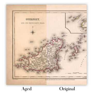
Map ageing
I have been asked hundreds of times over the years by customers if they could buy a map that looks even older.
Well, now you can, by selecting Aged before you add a map to your basket.
All the product photos you see on this page show the map in its Original form. This is what the map looks like today.
If you select Aged, I will age your map by hand, using a special and unique process developed through years of studying old maps, talking to researchers to understand the chemistry of aging paper, and of course... lots of practice!
If you're unsure, stick to the Original colour of the map. If you want something a bit darker and older looking, go for Aged.
Se non sei soddisfatto del tuo ordine per qualsiasi motivo, contattami per un rimborso senza problemi. Si prega di consultare la nostra politica di reso e rimborso per ulteriori informazioni.
Sono molto sicuro che ti piacerà la tua mappa restaurata o la stampa d'arte. Lo faccio dal 1984. Sono un venditore Etsy a 5 stelle. Ho venduto decine di migliaia di mappe e stampe d'arte e ho oltre 5.000 recensioni reali a 5 stelle.
Utilizzo un processo unico per restaurare mappe e opere d'arte che richiede molto tempo e lavoro. Trovare le mappe e le illustrazioni originali può richiedere mesi. Utilizzo tecnologia all'avanguardia e incredibilmente costosa per scannerizzare e restaurarle. Di conseguenza, garantisco che le mie mappe e stampe d'arte siano superiori alle altre - ecco perché posso offrire un rimborso senza problemi.
Quasi tutte le mie mappe e stampe d'arte sembrano fantastiche a grandi dimensioni (200 cm, 6,5 piedi+) e posso anche incorniciarle e consegnarle a te, tramite un corriere speciale per oggetti di grandi dimensioni. Contattami per discutere delle tue esigenze specifiche.
Or try searching for something!


