


Mappa infografica antica del Sud America, 1967: Grafici politici, sviluppo coloniale, lotte per l'indipendenza

-
![]() Handmade in the USA
Handmade in the USA
-
FREE Christmas delivery: check the deadline
Free delivery in 3-4 days
Your map should be delivered in 3-4 working days with free delivery, worldwide.
Free delivery may arrive on time, but Express Delivery at checkout is safer. Unframed orders have a better chance of arriving in time with free delivery.
New for 2025: After you order, you can send a beautiful gift preview by email, if you're worried it won't arrive on time.
We make maps by hand locally in 23 countries. If you're buying a gift for someone in another country, we will make the map locally to them.
You will never pay import tax or customs duty.
Check the Christmas delivery guide for order deadlines. Delivery times are starting to slow down, and will continue to slow down towards Christmas.
Express delivery is available at checkout which can reduce the delivery time to 1-2 days.
Please note that personalised maps, and larger framed maps, can take longer to produce and deliver.
If you need your order to arrive by a certain date, contact me and we can discuss your options.
-
90 day money back guarantee
ⓘ
90 giorni per restituire e ricevere un rimborso
I prodotti possono essere restituiti entro 90 giorni per un rimborso completo, o cambio con un altro prodotto.
Per articoli personalizzati e su misura, potremmo offrirti un credito in negozio o una carta regalo non scadente, poiché non possiamo rivendere ordini personalizzati.
Se hai domande, contattaci. Per ulteriori informazioni, consulta la nostra politica di restituzione e cambio.

My maps are rare, museum-grade, restored old maps sourced from libraries, auction houses and private collections across the globe.
Framing & free personalisation available
1. Select your size
2. Frame & personalize your map
There is limited framing & personalisation capacity available. Order by 10am tomorrow for Christmas delivery.


Gift message & custom finish

If you want to add a gift message, or a finish (jigsaw, aluminium board, etc.) that is not available here, please request it in the "order note" when you check out.
Every order is custom made, so if you need the size adjusted slightly, or printed on an unusual material, just let us know. We've done thousands of custom orders over the years, so there's (almost) nothing we can't manage.
You can also contact us before you order, if you prefer!

- Handmade locally. No import duty or tax
- FREE Delivery by Christmas
- Love it or your money back (90 days)
- Questions? WhatsApp me any time
Own a piece of history
5,000+ 5 star reviews


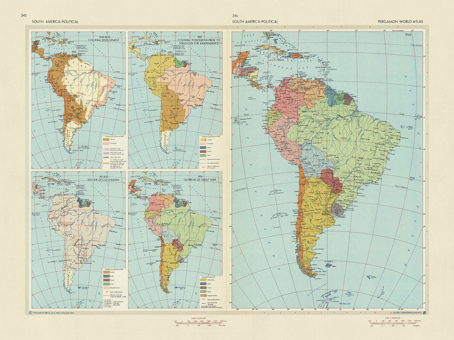
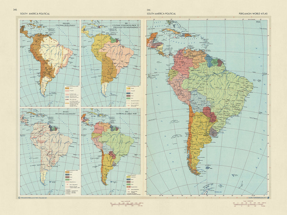
Questa mappa infografica politica e storica del Sud America, pubblicata originariamente nel 1967 dal Servizio Topografico dell'Esercito Polacco, è una rappresentazione visiva affascinante dello sviluppo politico e storico del Sud America. L'obiettivo principale della mappa è presentare dati sul Sud America in modo coinvolgente ed educativo, rendendola una risorsa preziosa per storici, geografi e chiunque sia interessato al ricco passato della regione.
Una delle caratteristiche più sorprendenti di questa mappa è l'inclusione di cinque mappe in miniatura, ciascuna rappresentante un diverso periodo della storia sudamericana. Queste mappe forniscono una panoramica completa dello sviluppo coloniale della regione, dall'arrivo dei coloni europei nel XVI secolo alle lotte per l'indipendenza nel XIX secolo e allo scoppio della Grande Guerra nel XX secolo. Presentando queste informazioni in un formato visivo, la mappa consente agli spettatori di comprendere facilmente i complessi processi storici che hanno plasmato il Sud America.
Oltre alle mappe storiche, la mappa principale include anche una ricchezza di altre informazioni, come le posizioni delle principali città, fiumi e montagne. Queste informazioni sono presentate in modo chiaro e conciso, rendendo facile per gli spettatori navigare nella mappa e trovare le informazioni che cercano. L'uso di diversi colori e simboli per rappresentare diverse caratteristiche migliora anche l'appeal visivo e l'usabilità della mappa.
Un altro aspetto notevole di questa mappa è il suo stile cartografico. Le mappe tematiche, come questa, sono progettate per enfatizzare caratteristiche o temi specifici, piuttosto che fornire una panoramica generale di un'area. In questo caso, la mappa si concentra sullo sviluppo politico e storico del Sud America, utilizzando infografiche per presentare i dati in modo visivamente coinvolgente. Questo approccio rende la mappa particolarmente utile per scopi educativi, poiché consente agli studenti di comprendere facilmente concetti storici complessi.
In generale, questa mappa infografica politica e storica del Sud America è una risorsa preziosa e visivamente attraente per chiunque sia interessato alla storia e alla geografia del Sud America. Le sue infografiche dettagliate, la ricchezza di informazioni e il chiaro stile cartografico la rendono un must-have per storici, geografi e chiunque altro abbia un interesse per questa affascinante regione.
Caratteristiche della Mappa:
- La mappa mostra i confini politici del Sud America così come esistevano nel 1966.
- Cinque mappe in miniatura mostrano lo sviluppo coloniale del Sud America dal 1500 al 1600, le possessioni coloniali prima delle lotte per l'indipendenza nel 1810, il declino del colonialismo dal 1811 al 1830, lo scoppio della Grande Guerra nel 1914 e le attuali contee nel 1966.
- La mappa include anche una varietà di altre informazioni, come le posizioni delle principali città, fiumi e montagne.
Contesto Storico:
- La mappa è stata pubblicata nel 1967, durante la Guerra Fredda.
- La Guerra Fredda è stata un periodo di tensione geopolitica tra gli Stati Uniti e l'Unione Sovietica e i loro rispettivi alleati.
- La mappa riflette le divisioni politiche del Sud America durante questo periodo.
Cartografo:
- La mappa è stata creata dal Servizio Topografico dell'Esercito Polacco.
- Il Servizio Topografico dell'Esercito Polacco era un'agenzia governativa responsabile della creazione di mappe per l'esercito polacco.
- La mappa è una testimonianza dell'abilità e dell'expertise del Servizio Topografico dell'Esercito Polacco.
Si prega di controllare attentamente le immagini per assicurarsi che una specifica città o luogo sia mostrato su questa mappa. Puoi anche contattarci e chiedere di controllare la mappa per te.
Questa mappa appare fantastica in ogni dimensione, ma consiglio sempre di optare per una dimensione più grande se hai spazio. In questo modo puoi facilmente distinguere tutti i dettagli.
Questa mappa appare incredibile in dimensioni fino a 50in (125cm). Se stai cercando una mappa più grande, ti prego di contattarci.
Il modello nelle immagini dell'annuncio tiene in mano la versione 18x24in (45x60cm) di questa mappa.
La quinta immagine dell'annuncio mostra un esempio del mio servizio di personalizzazione della mappa.
Se stai cercando qualcosa di leggermente diverso, dai un'occhiata alla mia collezione delle migliori mappe antiche per vedere se qualcosa ti colpisce.
Per favore contattami per verificare se una certa posizione, punto di riferimento o caratteristica è mostrata su questa mappa.
Questo sarebbe un meraviglioso regalo per un compleanno, Natale, Festa del Papà, partenza dal lavoro, anniversario o inaugurazione della casa per qualcuno delle aree coperte da questa mappa.
Questa mappa è disponibile come stampa giclée su carta opaca archivistica senza acidi, oppure puoi acquistarla incorniciata. La cornice è una semplice cornice nera che si adatta alla maggior parte degli stili. Ti prego di contattarmi se desideri un colore o materiale di cornice diverso. Le mie cornici sono dotate di un vetro acrilico super chiaro di grado museo (perspex/acrylite), che è significativamente meno riflettente del vetro, più sicuro e arriverà sempre in perfette condizioni.
This map is also available as a float framed canvas, sometimes known as a shadow gap framed canvas or canvas floater. The map is printed on artist's cotton canvas and then stretched over a handmade box frame. We then "float" the canvas inside a wooden frame, which is available in a range of colours (black, dark brown, oak, antique gold and white). This is a wonderful way to present a map without glazing in front. See some examples of float framed canvas maps and explore the differences between my different finishes.
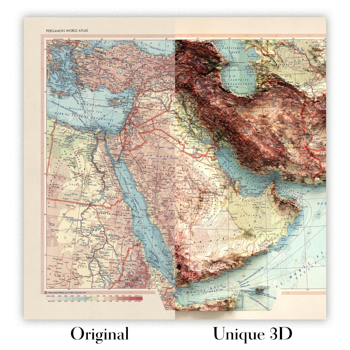
For something truly unique, this map is also available in "Unique 3D", our trademarked process that dramatically transforms the map so that it has a wonderful sense of depth. We combine the original map with detailed topography and elevation data, so that mountains and the terrain really "pop". For more info and examples of 3D maps, check my Unique 3D page.
For most orders, delivery time is about 3 working days. Personalised and customised products take longer, as I have to do the personalisation and send it to you for approval, which usually takes 1 or 2 days.
Please note that very large framed orders usually take longer to make and deliver.
If you need your order to arrive by a certain date, please contact me before you order so that we can find the best way of making sure you get your order in time.
I print and frame maps and artwork in 23 countries around the world. This means your order will be made locally, which cuts down on delivery time and ensures that it won't be damaged during delivery. You'll never pay customs or import duty, and we'll put less CO2 into the air.
All of my maps and art prints are well packaged and sent in a rugged tube if unframed, or surrounded by foam if framed.
I try to send out all orders within 1 or 2 days of receiving your order, though some products (like face masks, mugs and tote bags) can take longer to make.
If you select Express Delivery at checkout your order we will prioritise your order and send it out by 1-day courier (Fedex, DHL, UPS, Parcelforce).
Next Day delivery is also available in some countries (US, UK, Singapore, UAE) but please try to order early in the day so that we can get it sent out on time.
My standard frame is a gallery style black ash hardwood frame. It is simple and quite modern looking. My standard frame is around 20mm (0.8in) wide.
I use super-clear acrylic (perspex/acrylite) for the frame glass. It's lighter and safer than glass - and it looks better, as the reflectivity is lower.
Six standard frame colours are available for free (black, dark brown, dark grey, oak, white and antique gold). Custom framing and mounting/matting is available if you're looking for something else.
Most maps, art and illustrations are also available as a framed canvas. We use matte (not shiny) cotton canvas, stretch it over a sustainably sourced box wood frame, and then 'float' the piece within a wood frame. The end result is quite beautiful, and there's no glazing to get in the way.
All frames are provided "ready to hang", with either a string or brackets on the back. Very large frames will have heavy duty hanging plates and/or a mounting baton. If you have any questions, please get in touch.
See some examples of my framed maps and framed canvas maps.
Alternatively, I can also supply old maps and artwork on canvas, foam board, cotton rag and other materials.
If you want to frame your map or artwork yourself, please read my size guide first.
Alcune delle mie vecchie mappe sono ora disponibili come tele incorniciate. Per favore contattami se desideri ordinare una dimensione che non è disponibile nel mio negozio.
Le vecchie mappe su tela sono un'alternativa interessante alle mappe incorniciate in modo convenzionale. A seconda del tuo gusto personale e dell'arredamento della stanza, le mappe su tela possono "risaltare" un po' di più rispetto a una mappa incorniciata.
My maps are extremely high quality reproductions of original maps.
I source original, rare maps from libraries, auction houses and private collections around the world, restore them at my London workshop, and then use specialist giclée inks and printers to create beautiful maps that look even better than the original.
My maps are printed on acid-free archival matte (not glossy) paper that feels very high quality and almost like card. In technical terms the paper weight/thickness is 10mil/200gsm. It's perfect for framing.
I print with Epson ultrachrome giclée UV fade resistant pigment inks - some of the best inks you can find.
I can also make maps on canvas, cotton rag and other exotic materials.
Learn more about The Unique Maps Co.
Map personalisation
If you're looking for the perfect anniversary or housewarming gift, I can personalise your map to make it truly unique. For example, I can add a short message, or highlight an important location, or add your family's coat of arms.
The options are almost infinite. Please see my map personalisation page for some wonderful examples of what's possible.
To order a personalised map, select "personalise your map" before adding it to your basket.
Get in touch if you're looking for more complex customisations and personalisations.
Map ageing
I have been asked hundreds of times over the years by customers if they could buy a map that looks even older.
Well, now you can, by selecting Aged before you add a map to your basket.
All the product photos you see on this page show the map in its Original form. This is what the map looks like today.
If you select Aged, I will age your map by hand, using a special and unique process developed through years of studying old maps, talking to researchers to understand the chemistry of aging paper, and of course... lots of practice!
If you're unsure, stick to the Original colour of the map. If you want something a bit darker and older looking, go for Aged.
Se non sei soddisfatto del tuo ordine per qualsiasi motivo, contattami per un rimborso senza problemi. Si prega di consultare la nostra politica di reso e rimborso per ulteriori informazioni.
Sono molto sicuro che ti piacerà la tua mappa restaurata o la stampa d'arte. Lo faccio dal 1984. Sono un venditore Etsy a 5 stelle. Ho venduto decine di migliaia di mappe e stampe d'arte e ho oltre 5.000 recensioni reali a 5 stelle.
Utilizzo un processo unico per restaurare mappe e opere d'arte che richiede molto tempo e lavoro. Trovare le mappe e le illustrazioni originali può richiedere mesi. Utilizzo tecnologia all'avanguardia e incredibilmente costosa per scannerizzare e restaurarle. Di conseguenza, garantisco che le mie mappe e stampe d'arte siano superiori alle altre - ecco perché posso offrire un rimborso senza problemi.
Quasi tutte le mie mappe e stampe d'arte sembrano fantastiche a grandi dimensioni (200 cm, 6,5 piedi+) e posso anche incorniciarle e consegnarle a te, tramite un corriere speciale per oggetti di grandi dimensioni. Contattami per discutere delle tue esigenze specifiche.
Or try searching for something!


